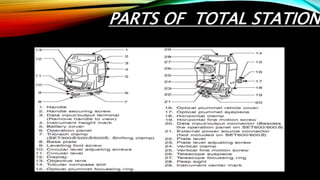
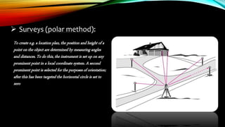
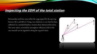
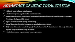
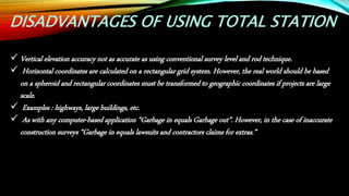
The document summarizes the principles and working of a total station. It describes a total station as an electronic theodolite integrated with an electronic distance meter that can measure slope distances. It discusses the parts of a total station and how they work using polar coordinates to determine a point's position through angle and distance measurements. The document outlines the advantages of total stations in allowing quick data collection and layout for construction sites. It also notes some disadvantages like less accurate vertical measurements compared to traditional surveying methods.
The Global Positioning System is a satellite-based radio navigation system for determination of precise position and time, using radio signals from the satellites, in real-time or in post-processing mode.
MODERN SURVEYING TECHNIQUES
WHAT IS SURVEYING?
•Surveyingisdefinedasthescienceofmakingmeasurementsespeciallyoftheearthsurface.Thisisbeingdonebyfindingoutthespatiallocation(relative/absolute)ofpointsonorneartheearthsurface.
•Differentmethodandinstrumentarebeingused
Edm is a surveying instrument used to measure the distance electronically. This Surveying Instrument is used in triangulation to measure the length of Base line because more accuracy is required to measure the length of base line.
Introduction, electromagnetic spectrum, electromagnetic distance measurement, types of EDM instruments, electronic digital theodolites, total station, digital levels, scanners for topographical survey, global positioning system.
What is a Total Station?
Capability of a Total Station
Important Operations of Total Station
Uses of Total Station
Advantages of Using Total Stations
Applications
A small description about the principle and operation of widely used instrument 'Total Station' in Civil Engineering and Global Positioning System through a technical view...!
Urban Entertainment Center, introduction, live case study, literature case st...Sumit Jha
Thesis topic- Urban Entertainment Centre, proposed at Mysore, Karnataka,
presentation include - introduction, live case study of Select city walk, New Delhi and Entertainment city, noida,
literature case study- Elante mall, chandigarh and Essel world, Mumbai, comparative charts, inferences, observations etc to understand this thesis topic in detail. thank you
entertainment city, Noida is another name of city where u can spend your quality time in shopping or entertaining yourself or your family. for more details architecture students can contact me. I will upload overall presentation after my thesis project this semester. thank you
We all have good and bad thoughts from time to time and situation to situation. We are bombarded daily with spiraling thoughts(both negative and positive) creating all-consuming feel , making us difficult to manage with associated suffering. Good thoughts are like our Mob Signal (Positive thought) amidst noise(negative thought) in the atmosphere. Negative thoughts like noise outweigh positive thoughts. These thoughts often create unwanted confusion, trouble, stress and frustration in our mind as well as chaos in our physical world. Negative thoughts are also known as “distorted thinking”.
Palestine last event orientationfvgnh .pptxRaedMohamed3
An EFL lesson about the current events in Palestine. It is intended to be for intermediate students who wish to increase their listening skills through a short lesson in power point.
The Roman Empire A Historical Colossus.pdfkaushalkr1407
The Roman Empire, a vast and enduring power, stands as one of history's most remarkable civilizations, leaving an indelible imprint on the world. It emerged from the Roman Republic, transitioning into an imperial powerhouse under the leadership of Augustus Caesar in 27 BCE. This transformation marked the beginning of an era defined by unprecedented territorial expansion, architectural marvels, and profound cultural influence.
The empire's roots lie in the city of Rome, founded, according to legend, by Romulus in 753 BCE. Over centuries, Rome evolved from a small settlement to a formidable republic, characterized by a complex political system with elected officials and checks on power. However, internal strife, class conflicts, and military ambitions paved the way for the end of the Republic. Julius Caesar’s dictatorship and subsequent assassination in 44 BCE created a power vacuum, leading to a civil war. Octavian, later Augustus, emerged victorious, heralding the Roman Empire’s birth.
Under Augustus, the empire experienced the Pax Romana, a 200-year period of relative peace and stability. Augustus reformed the military, established efficient administrative systems, and initiated grand construction projects. The empire's borders expanded, encompassing territories from Britain to Egypt and from Spain to the Euphrates. Roman legions, renowned for their discipline and engineering prowess, secured and maintained these vast territories, building roads, fortifications, and cities that facilitated control and integration.
The Roman Empire’s society was hierarchical, with a rigid class system. At the top were the patricians, wealthy elites who held significant political power. Below them were the plebeians, free citizens with limited political influence, and the vast numbers of slaves who formed the backbone of the economy. The family unit was central, governed by the paterfamilias, the male head who held absolute authority.
Culturally, the Romans were eclectic, absorbing and adapting elements from the civilizations they encountered, particularly the Greeks. Roman art, literature, and philosophy reflected this synthesis, creating a rich cultural tapestry. Latin, the Roman language, became the lingua franca of the Western world, influencing numerous modern languages.
Roman architecture and engineering achievements were monumental. They perfected the arch, vault, and dome, constructing enduring structures like the Colosseum, Pantheon, and aqueducts. These engineering marvels not only showcased Roman ingenuity but also served practical purposes, from public entertainment to water supply.
Unit 8 - Information and Communication Technology (Paper I).pdfThiyagu K
This slides describes the basic concepts of ICT, basics of Email, Emerging Technology and Digital Initiatives in Education. This presentations aligns with the UGC Paper I syllabus.
How to Make a Field invisible in Odoo 17Celine George
It is possible to hide or invisible some fields in odoo. Commonly using “invisible” attribute in the field definition to invisible the fields. This slide will show how to make a field invisible in odoo 17.
1. Presented by :-
Sumit Kumar Jha
BARCH/15006/14
B. Arch 4th semester
TOPIC : PRINCIPLES AND WORKING OF TOTAL STATION
BIRLA INSTITUTE OF TECHNOLOGY, MESRA
PATNA
2. INTRODUCTION
The total station is an electronic theodolite (transit) integrated with an electronic
distance meter (EDM) to read slope distances from the instrument to a particular
point.
A total station or total station theodolite is an electronic/optical instrument used in
modern surveying and building construction.
Robotic total stations allow the operator to control the instrument from a distance via
remote control. This eliminates the need for an assistant staff member as the operator
holds the reflector and controls the total station from the observed point.
4. PRINCIPLE
In order to describe the position of a point, two coordinates are
required. Polar coordinates need a line and an angle. Cartesian
coordinates need two lines within an orthogonal system. The total
station measures polar coordinates; these are recalculated as
Cartesian coordinates within the given orthogonal system, either
within the instrument itself or subsequently in the office
5. An angle represents the difference between two
directions.
The horizontal angle α between the two directions leading
to the points P1 and P2 is independent of the height
difference between those points, provided that the telescope
always moves in a strictly vertical plane when tilted,
whatever its horizontal orientation.
6. Plumbing down from a height point,
plumbing up from a ground point, and inspecting
a vertical line on a structure, can be carried out
exactly in just one telescope face, but only if the
telescope describes a precisely-vertical plane when
it is tilted.
WORKING OF TOTAL STATION
7. Surveys (polar method):
To create e.g. a location plan, the position and height of a
point on the object are determined by measuring angles
and distances. To do this, the instrument is set up on any
prominent point in a local coordinate system. A second
prominent point is selected for the purposes of orientation;
after this has been targeted the horizontal circle is set to
zero
8. Measuring distances without a reflector:
Each of the TCR total stations from Leica Geosystems includes not only a
conventional infrared distancer that measures to prisms, but also an integrated
laser distancer that requires no reflector. You can switch between these two
distancers.
This arrangement brings many advantages where points are accessible only with
difficulty or not at all, for example during the recording of frontages, in
positioning pipes
and for measurements across gorges or fences.
9. Automatic target recognition:
The TCA total stations from Leica Geosystems are equipped with an automatic target recognitionsystem
("ATR"). This makes targeting faster and easier. It is enough to point the telescope approximately at the
reflector; a touch on a button then automatically triggers the fine pointing and the angle- and distance
measurements, and records all of
the values. This technology also makes it possible to carry out fully automatic
measurements with the help of a computer. The ATR can also be switched to a mode in
which moving targets can be followed and measured; after establishing the initial
contact with the target the instrument locks on to it and tracks it.
10. During building alignment, it is useful to extrapolate the sides of
the building to beyond
the limits of the excavation and there to erect profile boards on
which the extensions are
marked exactly by hammering in nails. These can be connected to
strings or wires at
any time during the construction sequence, indicating the required
positions of the walls.
Setting out profile boards
11. Inspecting the line of sight
In new levels, the compensator has been adjusted at room temperature,
so that the line of sight is horizontal even if the instrument is tilted
slightly.
This situation changes if the temperature fluctuates by more than ten or
fifteen degrees, after a long journey, or if the instrument is subjected to
strong vibration.
It is then advisable to inspect the line of sight, particularly if more than
one target distance is being used.
12. Inspecting the EDM of the total station
Permanently mark four runs within the range typical for the user (e.g.
between 20 m and 200 m). Using a new distancer, or one that has been
calibrated on a standard baseline, measure these distances three times.
The mean values, corrected for atmospheric influences (refer to the
user manual) can be regarded as being the required values.
13. ADVANTAGE OF USING TOTAL STATION
Relatively quick collection of information
Multiple surveys can be performed at one set-up location.
Easy to perform distance and horizontal measurements with simultaneous calculation of project coordinates
(Northings, Eastings, and Elevations).
Layout of construction site quickly and efficiently.
Digital design data from CAD programs can be uploaded to data collector.
Daily survey information can also be quickly downloaded into CAD which eliminates data manipulation time
required using conventional survey techniques.
Multiple surveys can be performed at one set-up location.
14. DISADVANTAGES OF USING TOTAL STATION
Vertical elevation accuracy not as accurate as using conventional survey level and rod technique.
Horizontal coordinates are calculated on a rectangular grid system. However, the real world should be based
on a spheroid and rectangular coordinates must be transformed to geographic coordinates if projects are large
scale.
Examples : highways, large buildings, etc.
As with any computer-based application “Garbage in equals Garbage out”. However, in the case of inaccurate
construction surveys “Garbage in equals lawsuits and contractors claims for extras.”
15. CONCLUSION
Total station makes the measurements more accurate
It records the data in its inbuilt data recorder and generate maps in fraction of time
Hence time consuming will be less and total station made survey work easy
Hence total staion is total solution of survey work