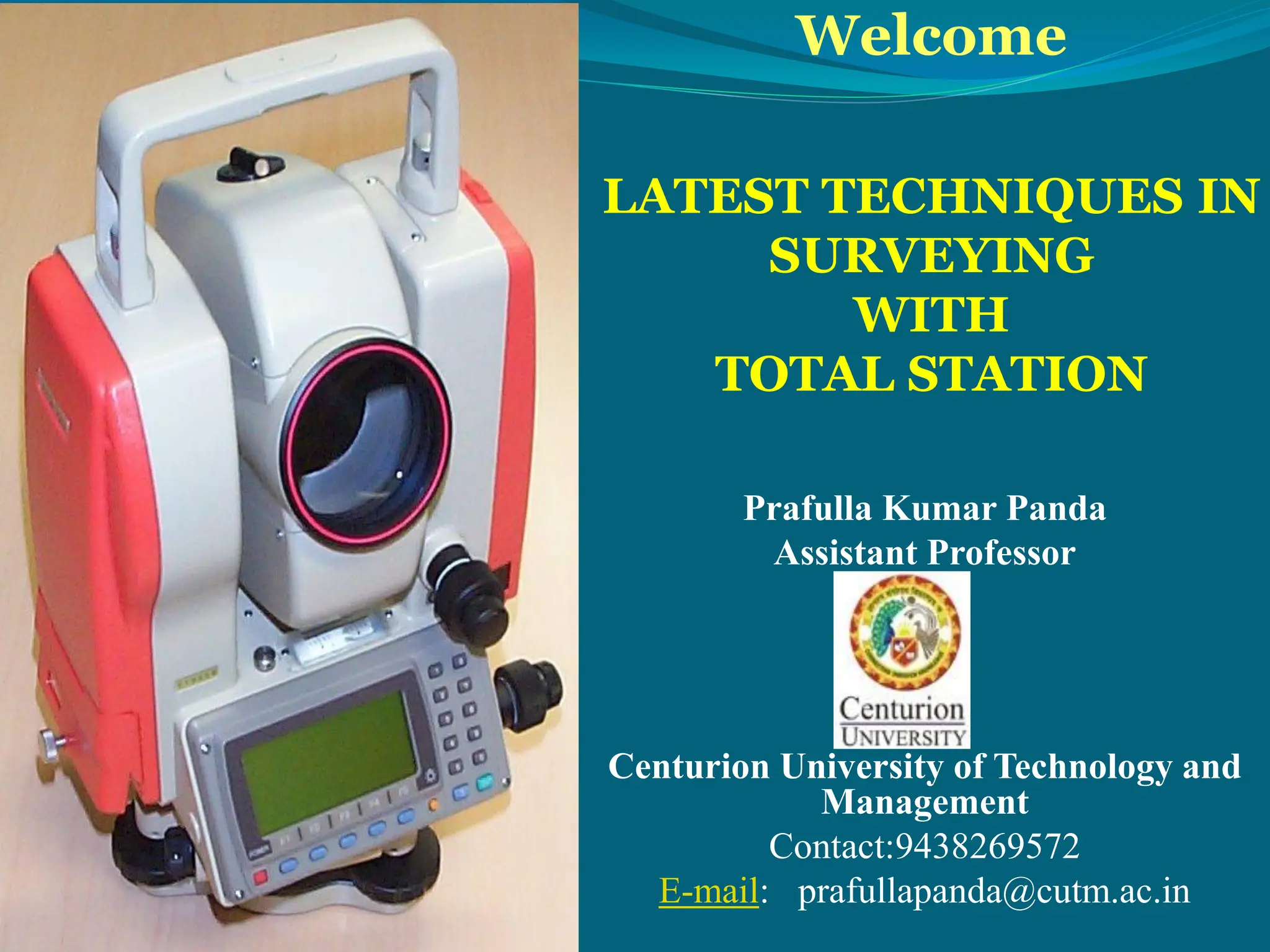
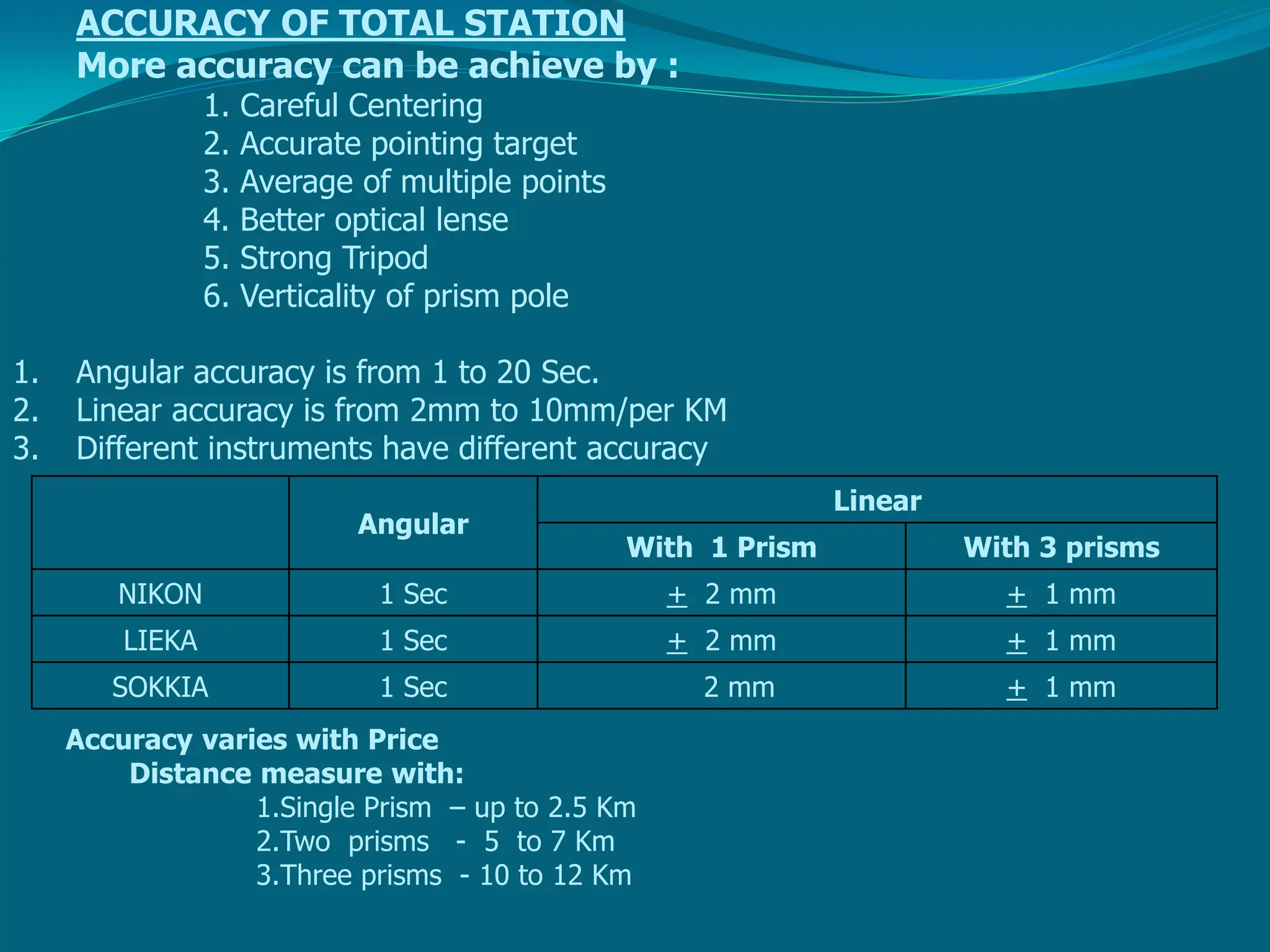
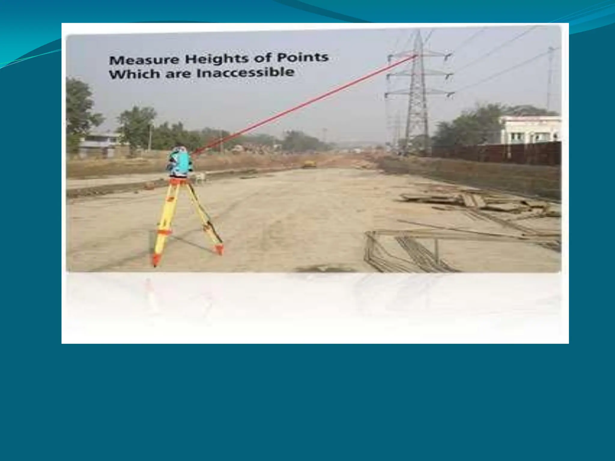
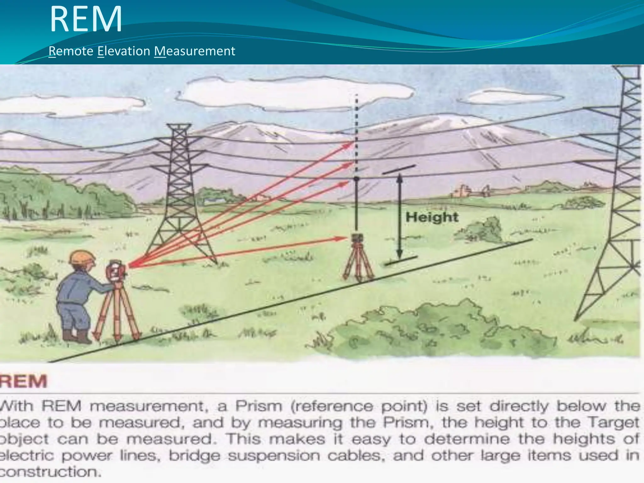
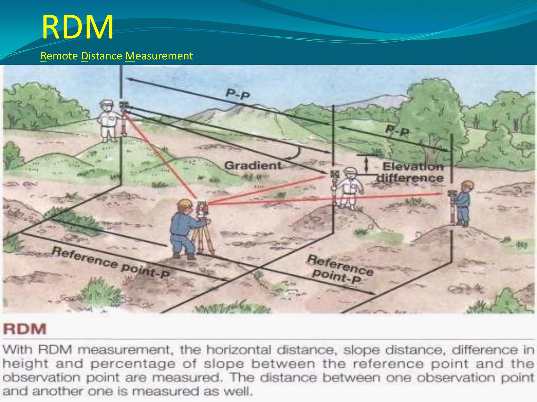
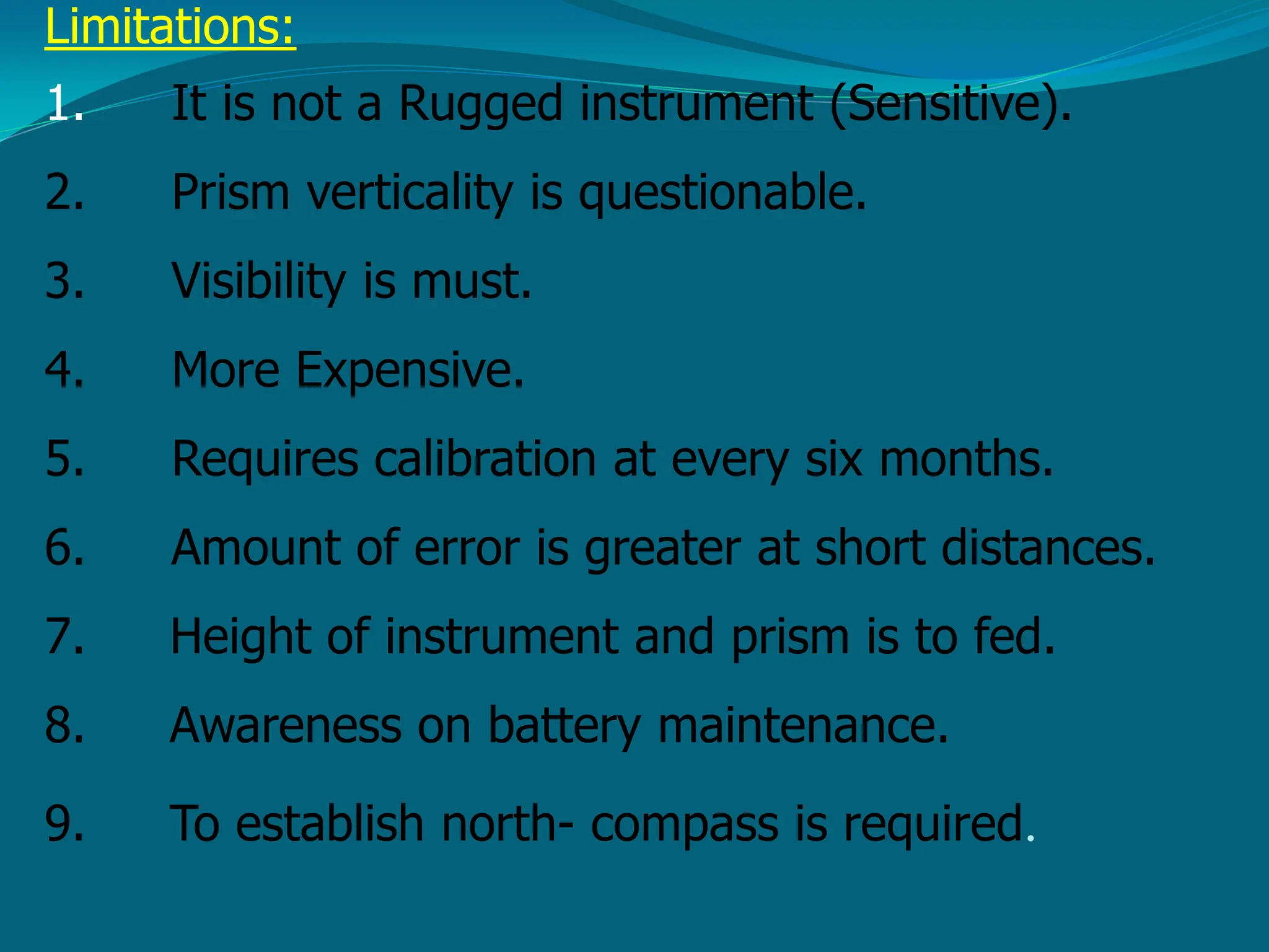
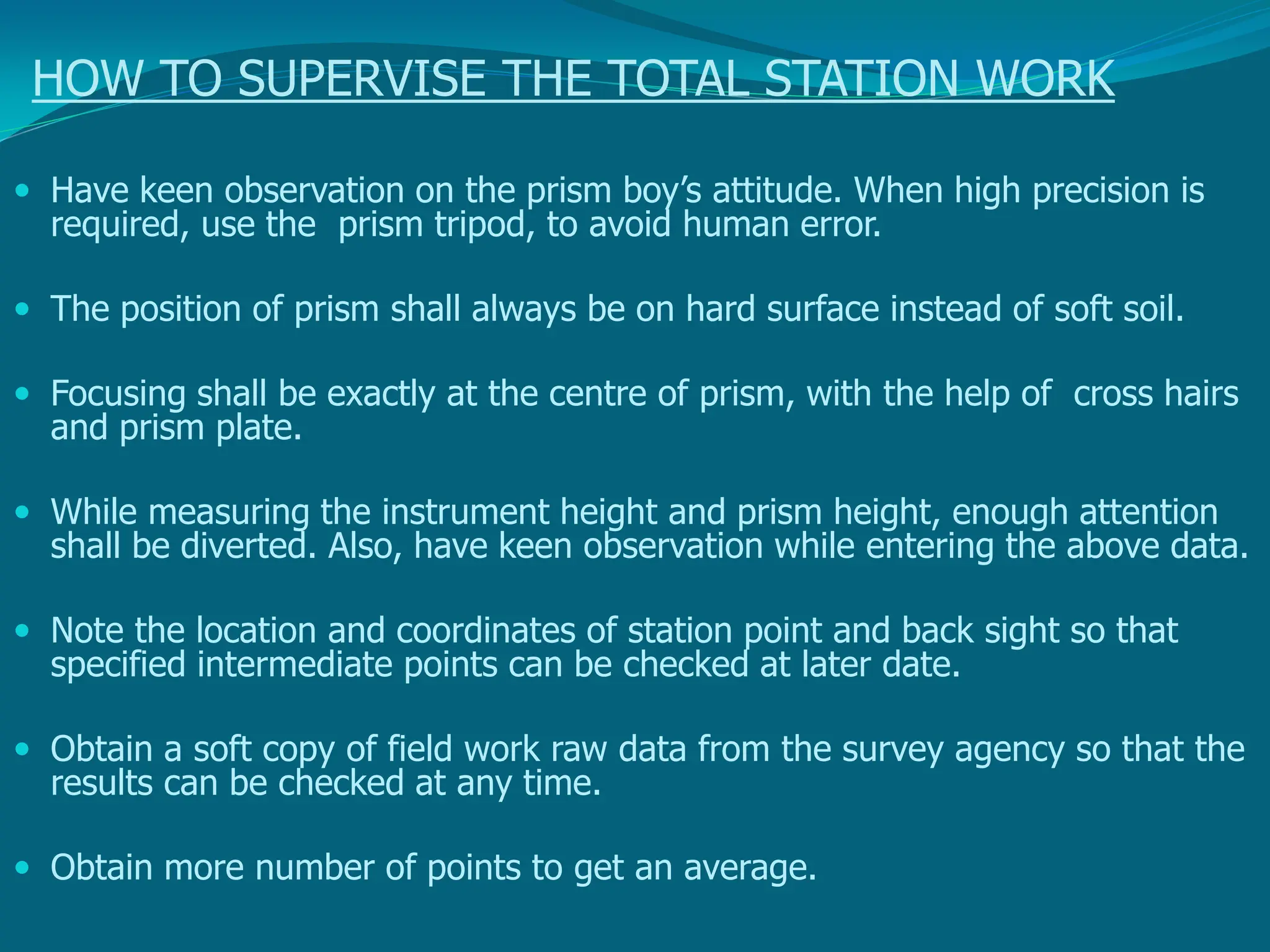
Welcome
LATEST TECHNIQUES IN
SURVEYING
WITH
TOTAL STATION
Prafulla Kumar Panda
Assistant Professor
Centurion University of Technology and
Management
Contact:9438269572
E-mail: prafullapanda@cutm.ac.in
Contents
• What is a Total Station?
• Capability of a Total Station
• Important Operations of Total Station
– Distance Measurement
– Angle Measurements
– Data Processing
– Display
– Electronic Book
• Uses of Total Station
• Advantages of Using Total Stations
• Applications
It is Process of determining
earthen features and recording
its relative position on to the paper
Types of survey
Traverse survey
Triangulation survey
Plane table survey
Which includes:
1. Linear Measurements
2. Angular Measurements
3. Height Measurements
Linear measurements we usually do with:
chain
Tape
Substance bar
EDM (Electronic distance measurement instrument)
GPS (Global Positioning System)
Angular measurements we usually do with:
Compass
Theodolite
Height we usually do with:
Dumpy level
Auto level
Theodolite & Digital leveler
What is a Total Station?
• Total station is a surveying equipment
combination of Electromagnetic Distance
Measuring Instrument and electronic
theodolite.
• It is also integrated with microprocessor,
electronic data collector and storage system.
• The instrument can be used
horizontal and vertical angles
to measure
as well as
sloping distance of object to the instrument.
Fig: T
otal station
ACCESSORIES FOR TOTAL STATION
Depending upon the prism measuring distance vary Lengths
up to about 2 km can be measured with a single prism, and up
to about 6 to 7 km with triple prism.
single prism
triple prism
Capability of a Total Station
Microprocessor unit in total station processes
the data collected to compute:
1. Average of multiple angles measured.
2. Average of multiple distance measured.
3. Horizontal distance.
4. Distance between any two points.
5. Elevation of objects and
6. All the three coordinates of the observed
points.
• Data collected and processed in a Total Station
can be downloaded to computers for further
processing.
• Total station is a compact instrument and
weighs 50 to 55 N.
• A person can easily carry it to the field.
• Total stations with different accuracy, in angle
measurement and different range of
measurements are available in the market.
• One such instrument manufactured by
SOKKIA Co. Ltd. Tokyo,Japan.
Fig: Parts of total station
Important Operations of Total
Station
• Distance Measurement
• Angle Measurements
• Data Processing
• Display
• Electronic Book
Basic components of Total station
 Prism reflector:
It is a combination of ranging rod, staff and and
optical cuboidal mirror.
having 2/3 lifts with 5cms interval graduations.
adjustable height from 1.5m to 3.75m.
More number of prisms, will give more accuracy.
•GUN: data screen LCD
eye piece
telescope 24x to 43x
environmental box
microprocessor with memory card of 1 or 2 GB capacity
1MB can store 800 points.
•Tripod: with different material
Aluminum tripod weighs 13 to 14lbs
Wooden tripod will be about 18 lbs.
•Optical and Laser plumb bobs.
•Battery –as an external attachment
with indicators
1.5hours charged battery can work for 3to 5 hours
ACCURACY OF TOTAL STATION
More accuracy can be achieve by :
1. Careful Centering
2. Accurate pointing target
3. Average of multiple points
4. Better optical lense
5. Strong Tripod
6. Verticality of prism pole
1. Angular accuracy is from 1 to 20 Sec.
2. Linear accuracy is from 2mm to 10mm/per KM
3. Different instruments have different accuracy
Angular
Linear
With 1 Prism With 3 prisms
NIKON 1 Sec + 2 mm + 1 mm
LIEKA 1 Sec + 2 mm + 1 mm
SOKKIA 1 Sec 2 mm + 1 mm
Accuracy varies with Price
Distance measure with:
1.Single Prism – up to 2.5 Km
2.Two prisms - 5 to 7 Km
3.Three prisms - 10 to 12 Km
Functions of T.S:
1. It simultaneously measures angles & distances and Record
2. Correcting the measured distance with:
1. Prism constant
2. Atmospheric Pr.
3. Temperature
4. Curvature of earth
5. Refraction correction
3. Computing the point elevation
4. Computing the coordinates of every point
5. Remote elevation measurement
6. Remote distance measurement
7. Area calculations
8. Data Transferring facility from instrument to S/W and S/W
to instrument
9. Format of conversion of units
Distance Measurement
• Electronic distance measuring (EDM)
instrument is a major part of total station.
• Its range varies from 2.8 km to 4.2 km.
• The accuracy of measurement varies from 5
mm to 10 mm per km measurement.
• They are used with automatic target
recognizer.
• The distance measured is always sloping
distance from instrument to the object.
Angle Measurements
• The electronic theodolite part of total station is
used for measuring vertical and horizontal
angle.
• For measurement of horizontal angles any
convenient direction may be taken as reference
direction.
• For vertical angle measurement vertical upward
(zenith) direction is taken as reference direction.
• The accuracy of angle measurement varies from
2 to 6 seconds.
REM
Remote Elevation Measurement
RDM
Remote Distance Measurement
Data Processing
• This instrument is provided with an inbuilt
microprocessor. The microprocessor averages
multiple observations. With the help of slope
distance and vertical and horizontal angles
measured, when height of axis of instrument and
targets are supplied, the microprocessor computes
the horizontal distance and X, Y,Z coordinates.
• The processor is capable of applying temperature
and pressure corrections to the measurements, if
atmospheric temperature and pressures are
supplied.
Display
• Electronic display unit is capable of displaying
various values when respective keys are
pressed.
• The system is capable of displaying horizontal
distance, vertical distance, horizontal and
vertical angles, difference in elevations of two
observed points and all the three coordinates of
the observed points.
Electronic Book
• Each point data can be stored in an electronic note
book (like compact disc).
• The capacity of electronic note book varies
from 2000 points to 4000 pointsdata.
• Surveyor can unload the data stored in note
book to computer and reuse the note book.
Uses of Total Station
• The total station instrument is mounted on a
tripod and is levelled by operating levelling
screws. Within a small range instrument is
capable of adjusting itself to the level position.
Then vertical and horizontal reference
directions are indexed using onboard keys.
• It is possible to set required units for distance,
temperature and pressure (FPS or SI).
Surveyor can select measurement mode like
fine, coarse, single or repeated.
• When target is sighted, horizontal and vertical
angles as well as sloping distances are
measured and by pressing appropriate keys
they are recorded along with point number.
Heights of instrument and targets can be keyed
in after measuring them with tapes. Then
processor computes various information about
the point and displays on screen.
• This information is also stored in the electronic
notebook. At the end of the day or whenever
electronic note book is full, the information
stored is downloaded to computers.
• The point data downloaded to the computer
can be used for further processing.
• There are software like auto civil and auto
plotter clubbed with Auto Cad which can be
used for plotting contours at any specified
interval and for plotting cross-section along
any specified line.
Advantages of Using Total Stations
• The following are some of the major
advantages of using total station over the
conventional surveying instruments:
• Field work is carried out very fast.
• Accuracy of measurement is high.
• Manual errors involved in reading and
recording are eliminated.
• Calculation of coordinates is very fast and
accurate. Even corrections for temperature and
pressure are automatically made.
• Computers can be employed for map making
and plotting contour and cross-sections.
Contour intervals and scales can be changed in
no time.
• However, surveyor should check the working
condition of the instruments before using. For
this standard points may be located near
survey office and before taking out instrument
for field work, its working is checked by
observing those standard points from the
specified instrument station.
Application of Total station:
1. Updating mapping
2. Topographic survey
3. Hydrographic survey
4. Cadastral survey
5. Project construction survey
6. Road, Rail Survey
7. Mining survey
Applications
• Total stations are mainly used by land
surveyors and civil engineers, either to record
features as in topographic surveying or to set
out features (such as roads, houses or
boundaries).
• They are also used by archaeologists to record
excavations and by police, crime scene
investigators, private accident reconstruction
and insurance companies to take
measurements of scenes.
Mining
• Total stations are the primary survey instrument
used in mining surveying.
• A total station is used to record the absolute
location of the tunnel walls, ceilings (backs),
and floors as the drifts of an underground mine
are driven.
• The recorded data are then downloaded into a
CAD program, and compared to the designed
layout of the tunnel.
• The survey party installs control stations at regular intervals.
These are small steel plugs installed in pairs in holes drilled
into walls or the back. For wall stations, two plugs are
installed in opposite walls, forming a line perpendicular to the
drift. For back stations, two plugs are installed in the back,
forming a line parallel to the drift.
Mechanical and electrical construction
• Total stations have become the highest standard for most
forms of construction layout.
• They are most often used in the X and Y axis to lay out the
locations of penetrations out of the underground utilities into
the foundation, between floors of a structure, as well as
roofing penetrations.
• Because more commercial and industrial construction jobs have
become centered around building information modeling (BIM),
the coordinates for almost every pipe, conduit, duct and hanger
support are available with digital precision.
• The application of communicating a virtual model to a tangible
construction potentially eliminates labor costs related to moving
poorly measured systems, as well as time spent laying out these
systems in the midst of a full blown construction job in
progress.
Meteorology
• Meteorologists also use total stations to track weather
balloons for determining upper- level winds.
• With the average ascent rate of the weather balloon known or
assumed, the change in azimuth and elevation readings
provided by the total station as it tracks the weather balloon
over time are used to compute the wind speed and direction at
different altitudes.
• Additionally, the total station is used to track
ceiling balloons to determine the height of
cloud layers.
• Such upper-level wind data is often used for
aviation weather forecasting and rocket
launches.
Applications of Total Station in surveying
AREA CALCULATION:
 Area can be computed of any figure just by giving the
coordinates of the corner of the figure.
 Area Calculation.
 Process of finding the area of a closed figure.
Computer software packages
The following post processing computer software
packages are in use for various engineering
applications.
1.Arc Pad, arc view, arc info
-conversion from raster to vector form
2.Micro Station - Map generation
3.Erdas – Image processing s/w
4.Surfer, Auto plotter, Civil cad, Pythagarus
– preparation of contours
5. Survey aid – to draw c/s and l/s
The information received is to be analyzed depending
on the users requirement.
Limitations:
1. It is not a Rugged instrument (Sensitive).
2. Prism verticality is questionable.
3. Visibility is must.
4. More Expensive.
5. Requires calibration at every six months.
6. Amount of error is greater at short distances.
7. Height of instrument and prism is to fed.
8. Awareness on battery maintenance.
9. To establish north- compass is required.
SAFETY PRECAUTIONS
1. Focusing directly at the sun, can result - loss of eyesight on the spot. Use a filter when
observing the sun.
2. Never remove the hand grip carelessly. If the grip is loosely or incompletely attached,
the instrument could fall and may cause a serious injury.
3. Make sure not to short the battery terminals. If these are shorted, the resulting high
current would not only damage to the battery, but also start a fire.
4. If the instrument or battery comes in contact with water, wipe it off as quickly as
possible and set it in a dry place for a while. When it is completely dry, put it back in
the case.
5. Never disassemble the instrument, if you find a problem. Contact the dealer.
HOW TO SUPERVISE THE TOTAL STATION WORK
 Have keen observation on the prism boy’s attitude. When high precision is
required, use the prism tripod, to avoid human error.
 The position of prism shall always be on hard surface instead of soft soil.
 Focusing shall be exactly at the centre of prism, with the help of cross hairs
and prism plate.
 While measuring the instrument height and prism height, enough attention
shall be diverted. Also, have keen observation while entering the above data.
 Note the location and coordinates of station point and back sight so that
specified intermediate points can be checked at later date.
 Obtain a soft copy of field work raw data from the survey agency so that the
results can be checked at any time.
 Obtain more number of points to get an average.
Thank you for your attention

Total-Station.pdf Eng engineering geology engineering notes all notes

  • 1.
    Welcome LATEST TECHNIQUES IN SURVEYING WITH TOTALSTATION Prafulla Kumar Panda Assistant Professor Centurion University of Technology and Management Contact:9438269572 E-mail: prafullapanda@cutm.ac.in
  • 2.
    Contents • What isa Total Station? • Capability of a Total Station • Important Operations of Total Station – Distance Measurement – Angle Measurements – Data Processing – Display – Electronic Book • Uses of Total Station • Advantages of Using Total Stations • Applications
  • 3.
    It is Processof determining earthen features and recording its relative position on to the paper
  • 4.
    Types of survey Traversesurvey Triangulation survey Plane table survey Which includes: 1. Linear Measurements 2. Angular Measurements 3. Height Measurements
  • 5.
    Linear measurements weusually do with: chain Tape Substance bar EDM (Electronic distance measurement instrument) GPS (Global Positioning System) Angular measurements we usually do with: Compass Theodolite Height we usually do with: Dumpy level Auto level Theodolite & Digital leveler
  • 6.
    What is aTotal Station? • Total station is a surveying equipment combination of Electromagnetic Distance Measuring Instrument and electronic theodolite. • It is also integrated with microprocessor, electronic data collector and storage system. • The instrument can be used horizontal and vertical angles to measure as well as sloping distance of object to the instrument.
  • 7.
  • 8.
  • 9.
    ACCESSORIES FOR TOTALSTATION Depending upon the prism measuring distance vary Lengths up to about 2 km can be measured with a single prism, and up to about 6 to 7 km with triple prism. single prism triple prism
  • 10.
    Capability of aTotal Station Microprocessor unit in total station processes the data collected to compute: 1. Average of multiple angles measured. 2. Average of multiple distance measured. 3. Horizontal distance. 4. Distance between any two points. 5. Elevation of objects and 6. All the three coordinates of the observed points.
  • 11.
    • Data collectedand processed in a Total Station can be downloaded to computers for further processing. • Total station is a compact instrument and weighs 50 to 55 N. • A person can easily carry it to the field. • Total stations with different accuracy, in angle measurement and different range of measurements are available in the market. • One such instrument manufactured by SOKKIA Co. Ltd. Tokyo,Japan.
  • 12.
    Fig: Parts oftotal station
  • 13.
    Important Operations ofTotal Station • Distance Measurement • Angle Measurements • Data Processing • Display • Electronic Book
  • 14.
    Basic components ofTotal station  Prism reflector: It is a combination of ranging rod, staff and and optical cuboidal mirror. having 2/3 lifts with 5cms interval graduations. adjustable height from 1.5m to 3.75m. More number of prisms, will give more accuracy.
  • 15.
    •GUN: data screenLCD eye piece telescope 24x to 43x environmental box microprocessor with memory card of 1 or 2 GB capacity 1MB can store 800 points. •Tripod: with different material Aluminum tripod weighs 13 to 14lbs Wooden tripod will be about 18 lbs. •Optical and Laser plumb bobs. •Battery –as an external attachment with indicators 1.5hours charged battery can work for 3to 5 hours
  • 16.
    ACCURACY OF TOTALSTATION More accuracy can be achieve by : 1. Careful Centering 2. Accurate pointing target 3. Average of multiple points 4. Better optical lense 5. Strong Tripod 6. Verticality of prism pole 1. Angular accuracy is from 1 to 20 Sec. 2. Linear accuracy is from 2mm to 10mm/per KM 3. Different instruments have different accuracy Angular Linear With 1 Prism With 3 prisms NIKON 1 Sec + 2 mm + 1 mm LIEKA 1 Sec + 2 mm + 1 mm SOKKIA 1 Sec 2 mm + 1 mm Accuracy varies with Price Distance measure with: 1.Single Prism – up to 2.5 Km 2.Two prisms - 5 to 7 Km 3.Three prisms - 10 to 12 Km
  • 17.
    Functions of T.S: 1.It simultaneously measures angles & distances and Record 2. Correcting the measured distance with: 1. Prism constant 2. Atmospheric Pr. 3. Temperature 4. Curvature of earth 5. Refraction correction 3. Computing the point elevation 4. Computing the coordinates of every point 5. Remote elevation measurement 6. Remote distance measurement 7. Area calculations 8. Data Transferring facility from instrument to S/W and S/W to instrument 9. Format of conversion of units
  • 18.
    Distance Measurement • Electronicdistance measuring (EDM) instrument is a major part of total station. • Its range varies from 2.8 km to 4.2 km. • The accuracy of measurement varies from 5 mm to 10 mm per km measurement. • They are used with automatic target recognizer. • The distance measured is always sloping distance from instrument to the object.
  • 19.
    Angle Measurements • Theelectronic theodolite part of total station is used for measuring vertical and horizontal angle. • For measurement of horizontal angles any convenient direction may be taken as reference direction. • For vertical angle measurement vertical upward (zenith) direction is taken as reference direction. • The accuracy of angle measurement varies from 2 to 6 seconds.
  • 21.
  • 22.
  • 23.
    Data Processing • Thisinstrument is provided with an inbuilt microprocessor. The microprocessor averages multiple observations. With the help of slope distance and vertical and horizontal angles measured, when height of axis of instrument and targets are supplied, the microprocessor computes the horizontal distance and X, Y,Z coordinates. • The processor is capable of applying temperature and pressure corrections to the measurements, if atmospheric temperature and pressures are supplied.
  • 24.
    Display • Electronic displayunit is capable of displaying various values when respective keys are pressed. • The system is capable of displaying horizontal distance, vertical distance, horizontal and vertical angles, difference in elevations of two observed points and all the three coordinates of the observed points.
  • 25.
    Electronic Book • Eachpoint data can be stored in an electronic note book (like compact disc). • The capacity of electronic note book varies from 2000 points to 4000 pointsdata. • Surveyor can unload the data stored in note book to computer and reuse the note book.
  • 26.
    Uses of TotalStation • The total station instrument is mounted on a tripod and is levelled by operating levelling screws. Within a small range instrument is capable of adjusting itself to the level position. Then vertical and horizontal reference directions are indexed using onboard keys.
  • 27.
    • It ispossible to set required units for distance, temperature and pressure (FPS or SI). Surveyor can select measurement mode like fine, coarse, single or repeated.
  • 28.
    • When targetis sighted, horizontal and vertical angles as well as sloping distances are measured and by pressing appropriate keys they are recorded along with point number. Heights of instrument and targets can be keyed in after measuring them with tapes. Then processor computes various information about the point and displays on screen.
  • 29.
    • This informationis also stored in the electronic notebook. At the end of the day or whenever electronic note book is full, the information stored is downloaded to computers.
  • 30.
    • The pointdata downloaded to the computer can be used for further processing. • There are software like auto civil and auto plotter clubbed with Auto Cad which can be used for plotting contours at any specified interval and for plotting cross-section along any specified line.
  • 31.
    Advantages of UsingTotal Stations • The following are some of the major advantages of using total station over the conventional surveying instruments: • Field work is carried out very fast. • Accuracy of measurement is high. • Manual errors involved in reading and recording are eliminated.
  • 32.
    • Calculation ofcoordinates is very fast and accurate. Even corrections for temperature and pressure are automatically made. • Computers can be employed for map making and plotting contour and cross-sections. Contour intervals and scales can be changed in no time.
  • 33.
    • However, surveyorshould check the working condition of the instruments before using. For this standard points may be located near survey office and before taking out instrument for field work, its working is checked by observing those standard points from the specified instrument station.
  • 34.
    Application of Totalstation: 1. Updating mapping 2. Topographic survey 3. Hydrographic survey 4. Cadastral survey 5. Project construction survey 6. Road, Rail Survey 7. Mining survey
  • 35.
    Applications • Total stationsare mainly used by land surveyors and civil engineers, either to record features as in topographic surveying or to set out features (such as roads, houses or boundaries). • They are also used by archaeologists to record excavations and by police, crime scene investigators, private accident reconstruction and insurance companies to take measurements of scenes.
  • 36.
    Mining • Total stationsare the primary survey instrument used in mining surveying. • A total station is used to record the absolute location of the tunnel walls, ceilings (backs), and floors as the drifts of an underground mine are driven. • The recorded data are then downloaded into a CAD program, and compared to the designed layout of the tunnel.
  • 37.
    • The surveyparty installs control stations at regular intervals. These are small steel plugs installed in pairs in holes drilled into walls or the back. For wall stations, two plugs are installed in opposite walls, forming a line perpendicular to the drift. For back stations, two plugs are installed in the back, forming a line parallel to the drift.
  • 38.
    Mechanical and electricalconstruction • Total stations have become the highest standard for most forms of construction layout. • They are most often used in the X and Y axis to lay out the locations of penetrations out of the underground utilities into the foundation, between floors of a structure, as well as roofing penetrations.
  • 39.
    • Because morecommercial and industrial construction jobs have become centered around building information modeling (BIM), the coordinates for almost every pipe, conduit, duct and hanger support are available with digital precision. • The application of communicating a virtual model to a tangible construction potentially eliminates labor costs related to moving poorly measured systems, as well as time spent laying out these systems in the midst of a full blown construction job in progress.
  • 40.
    Meteorology • Meteorologists alsouse total stations to track weather balloons for determining upper- level winds. • With the average ascent rate of the weather balloon known or assumed, the change in azimuth and elevation readings provided by the total station as it tracks the weather balloon over time are used to compute the wind speed and direction at different altitudes.
  • 41.
    • Additionally, thetotal station is used to track ceiling balloons to determine the height of cloud layers. • Such upper-level wind data is often used for aviation weather forecasting and rocket launches.
  • 42.
    Applications of TotalStation in surveying AREA CALCULATION:  Area can be computed of any figure just by giving the coordinates of the corner of the figure.  Area Calculation.  Process of finding the area of a closed figure.
  • 43.
    Computer software packages Thefollowing post processing computer software packages are in use for various engineering applications. 1.Arc Pad, arc view, arc info -conversion from raster to vector form 2.Micro Station - Map generation 3.Erdas – Image processing s/w 4.Surfer, Auto plotter, Civil cad, Pythagarus – preparation of contours 5. Survey aid – to draw c/s and l/s The information received is to be analyzed depending on the users requirement.
  • 44.
    Limitations: 1. It isnot a Rugged instrument (Sensitive). 2. Prism verticality is questionable. 3. Visibility is must. 4. More Expensive. 5. Requires calibration at every six months. 6. Amount of error is greater at short distances. 7. Height of instrument and prism is to fed. 8. Awareness on battery maintenance. 9. To establish north- compass is required.
  • 45.
    SAFETY PRECAUTIONS 1. Focusingdirectly at the sun, can result - loss of eyesight on the spot. Use a filter when observing the sun. 2. Never remove the hand grip carelessly. If the grip is loosely or incompletely attached, the instrument could fall and may cause a serious injury. 3. Make sure not to short the battery terminals. If these are shorted, the resulting high current would not only damage to the battery, but also start a fire. 4. If the instrument or battery comes in contact with water, wipe it off as quickly as possible and set it in a dry place for a while. When it is completely dry, put it back in the case. 5. Never disassemble the instrument, if you find a problem. Contact the dealer.
  • 46.
    HOW TO SUPERVISETHE TOTAL STATION WORK  Have keen observation on the prism boy’s attitude. When high precision is required, use the prism tripod, to avoid human error.  The position of prism shall always be on hard surface instead of soft soil.  Focusing shall be exactly at the centre of prism, with the help of cross hairs and prism plate.  While measuring the instrument height and prism height, enough attention shall be diverted. Also, have keen observation while entering the above data.  Note the location and coordinates of station point and back sight so that specified intermediate points can be checked at later date.  Obtain a soft copy of field work raw data from the survey agency so that the results can be checked at any time.  Obtain more number of points to get an average.
  • 47.
    Thank you foryour attention