Download as PDF, PPTX
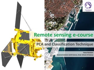


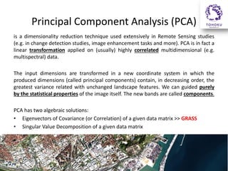
![PCA Analysis (for Landsat 8 OLI)
PC has the most positive or negative contribution
i.pca input=B1,B2,B3,B4,B5,B7 output_prefix=PCA
•
•
•
•
•
•
PC1 2553.26 (-0.2998,-0.2313,-0.4177,-0.2342,-0.6702,-0.4221) [91.10%]
PC2 168.11 (-0.4841,-0.2400,-0.3196, 0.6894, 0.3382,-0.1276) [ 6.00%]
PC3 58.00 (-0.3717,-0.2467,-0.3222,-0.5897, 0.3657, 0.4645) [ 2.07%]
PC4 16.27 ( 0.1545, 0.0497,-0.3195, 0.3426,-0.4678, 0.7317) [ 0.58%]
PC5 6.27 (-0.6507, 0.0183, 0.6650, 0.0396,-0.2856, 0.2254) [ 0.22%]
PC6 0.92 ( 0.3005,-0.9084, 0.2743, 0.0572,-0.0494, 0.0596) [ 0.03%]
Eigen values, (vectors), and [percent importance]:
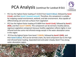
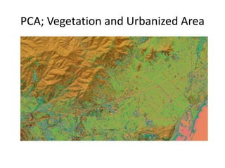
The band ratio derived from PC1 is B5/B2. Similarly, the results for PC2–PC3
lead to the choice of the ratios B1/B4, and B4/B7, respectively](https://image.slidesharecdn.com/pcaclassification-140224003650-phpapp02/85/PCA-and-Classification-10-320.jpg)
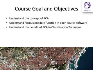
![Exercise!
• Run i.pca for SPOT6!
i.pca input=spot1,spot2,spot3,spot4 output_prefix=pca.spot
1. Eigen values, (vectors), and [percent importance]:
2. Band Ratio:
?](https://image.slidesharecdn.com/pcaclassification-140224003650-phpapp02/85/PCA-and-Classification-13-320.jpg)

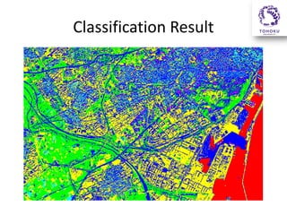

This remote sensing e-course focuses on principal component analysis (PCA) and classification techniques using remotely sensed SPOT 6 and Landsat 8 data. The course will illustrate how to analyze and classify the satellite imagery for land use mapping using open source GRASS software. Students will learn about PCA, how it is calculated in GRASS, and its benefits for classification. Exercises will have students run PCA on SPOT6 data to determine optimal band ratios for classification and produce a land use map.


