SlideShare a Scribd company logo
ThesisPresentation
on
Feature Extraction Using Deep Learning methods
by
PAWAN SINGH
2019GI02
GIS CELL
Under the supervision of
DR. RAMJI DWIVEDI
ASSISTANT PROFESSOR
GIS CELL
TABLE OF CONTENT
• Introduction
• Research gap
• Motivation
• Thesis Objective
• Study area
• Dataset used and other derived dataset
• Methodology
• Results
• Conclusion
• Future work
• Achievement and Publications
• References
INTRODUCTION
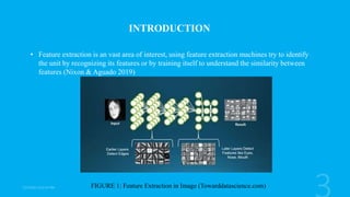
• Feature extraction is an vast area of interest, using feature extraction machines try to identify
the unit by recognizing its features or by training itself to understand the similarity between
features (Nixon & Aguado 2019)
FIGURE 1: Feature Extraction in Image (Towarddatascience.com)
• Using only color satellite imagery we can try to extract any feature but limited by the spatial
resolution.
• Not to get to every features in the satellite imagery we focused on one feature which is the
landslide.
• Landslide, one of the hazardous geological events, is the downslope movement of rock mass
and debris. It has no one particular reason for its occurrence. It can happen due to multiple
reasons like Heavy rainfall, cloud burst, earthquake, improper human settlement or
unorganized constructions (Haigh et al., 2012).
FIGURE 2: Spectral Bands of Landsat 8(blogs.fuberlin.de)
RESEARCH GAP
• In India landslide inventory is managed in Bhuvan and Bhukosh portal and latest data
available of Uttarakhand is from 2016. Even though Uttarakhand if one of the worst affected
state by landslides (Khanduri et al., 2018).
• Landsat 8 is very well explored by foreign authors but for Indian subcontinent potential of
Landsat 8 is yet to be explored.
• Uses of parameters by few authors to identify landslides are sometime ambiguous.
• Use of high spatial resolution data for the landslide detection (Martha et al. 2019).
Motivation
• To use Landsat 8 data to extract the information of landslide pixel
• To explore the potential for google earth engine
• Exploring behavior of our data over neural network
• Using pre-trained deep learning model
THESIS OBJECTIVES
This thesis has the following objectives:
a) To investigate the performance of the machine learning algorithms such as Support vector
machine, Random Forest, Decision tree, Naive Bayes, and minimum distance to classify our
study area into land cover followed by identifying landslides pixel using Google Earth Engine
(GEE).
b) To design and evaluate the Deep Neural Network performance in identifying the landslides
pixels.
c) To investigate the efficacy of various deep learning modules available in MATLAB.
STUDY AREA
FIGURE 3: Region of Rudraprayag along with landslide points
DATASET USED
Data Resolution Source
Landsat 8 30 m/pixel https://earthexplorer.usgs.gov/
JAXAALOS DSM 30 m https://earthexplorer.usgs.gov/
Landslide Inventory https://bhukosh.gsi.gov.in/
Table 1: Primary Dataset
Derived datasets
Figure 4 :Flowchart of Data preparation
Dataset preview
Figure 5: Polygon marking in earth engine for Data 1 and Data 2
Figure 6: Data 2
Dataset preview
B1 to B8 – reflectance value
DSM – Surface model in meters
Slope – In degrees
Label- 1 as landslide and 0 as no
landslide
Figure 7: Data 3
Dataset preview
PROCESSING ENVIRONMENT
1. QGIS: We used QGIS to visualize the landslide point and to acquire Data 3. Final results
were also visualized in it.
2. Google Earth Engine: it has petabyte of regularly updated satellite imagery and remote
sensing data, it even provide cloud computation platform. It can perform all basic GIS
operation in it.
3. Google colab : it is online python development environment. It also provide performance
accelerator like GPU and TPU.
4. MATLAB: it is an Mathematical processing environment . We used it to do process like
image cropping and to perform available pre-trained deep learning models in it.
METHODOLOGY
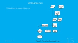
i) Methodology for research objective (a)
Figure 8: Flowchart for objective (a)
ii) Methodology for research objective (b)
Figure 9: Flowchart for objective (b)
Figure 10: Design of Neural Network using Tensor flow
iii) Methodology for research objective (c)
Figure 11: Flowchart for objective (c)
RESULTS
i) Results for Methodology (a)
Figure 12: (left to right) Classification of the study area Using Support vector machine,
minimum distance, Naïve Bayes
Figure 13:Classification of the study area Using Random forest (left), and smile cart (right).
Figure 14: Location near Ukhimath and Location near Banadhar Identified as Landslide while classification
ii) Results for Methodology (b)
Figure 15:Graph of accuracy and loss of test and train data at every epoch
TP FP TN FN Accuracy Precision Recall F1 score
1070 22 2086 33 98.28 97.9 97 96.8
Table 2: Table showing metrics of classification done by model
Figure 16: Classifying a location into two classes Landslide or not a landslide
(a)Picture Showing area in Landsat 8 (b) Picture Showing area in Google Image (c) Location
after Classification Red dot shows it is a landslide and blue Not a landslide
iii) Results for Methodology (c)
Figure 17: Progress graph of the Google Net Deep learning Module
Table 3 : Evaluation and Comparison of all Deep learning Model
Method TP TN FP FN Accuracy Precision Recall F1 score
GoogleNet 14 91 13 7 0.84 0.51852 0.66667 0.58333
Inception v3 11 99 6 9 0.88 0.64706 0.55 0.59459
NasNet Mobile 5 103 1 16 0.864 0.83333 0.2381 0.37037
ResNet-18 10 101 3 11 0.888 0.76923 0.47619 0.58824
ResNet-50 13 102 2 8 0.92 0.86667 0.61905 0.72222
Shufflenet 14 100 4 7 0.912 0.77778 0.66667 0.71795
CONCLUSION
Using multiple method we saw we can find the location of the landslides pixels and it also be
visualized on map. Main learnings derived while going through the experiment are as follow:
a) Data is very important, more the data more better will be the performance of the model.
b) If Variety of landslides pixel given to model it can degrade the performance of the model, so
addition of parameters needs to be kept in mind while training .
c) More number of parameter doesn’t promise high performance but the correct parameter which
can easily differentiate will help to improve the performance.
d) High accuracy or high metrics parameters sometimes doesn’t reflect on map.
FUTURE
We can take inspiration from the already developed deep learning model and redesign our network
which can very identify the more number of feature.
Finding or developing new indices/parameters based on features focused can help to get better result.
A platform can be developed where in new satellite imagery we can automatically detect changes
related to landslides and can update the location of new or enhanced landslides.
Achievements & Publication
• Methodology (a) was performed using ISRO’s LISIII data in the IITB-ISRO-AICTE Mapathon
2021 and chosen in top 25 list of winners
• Paper title “PIXEL BASED LANDSLIDE IDENTIFICATION USING LANDSAT 8 AND GEE”
coauthors Vipin kumar maurya & Dr. Ramji Dwivedi is presented in IEEE IGARSS 2021 conference
and was based on methodology (a).
REFRENCES
• Khanduri, S., Sajwan, K. S., Rawat, A., Dhyani, C., & Kapoor, S. (2018). Disaster in
Rudraprayag District of Uttarakhand Himalaya: a special emphasis on geomorphic changes
and slope instability. J Geogr Nat Disast, 8(218), 2167-0587.
• Nixon, M., & Aguado, A. (2019). Feature extraction and image processing for computer
vision. Academic press.
• Haigh, M., & Rawat, J. S. (2012). Landslide disasters: Seeking causes–A case study from
Uttarakhand, India. In Management of Mountain Watersheds (pp. 218-253). Springer,
Dordrecht. https://doi.org/10.1007/978-94007-2476-1_18
• Martha, T. R., Roy, P., Khanna, K., Mrinalni, K., & Kumar, K. V. (2019). Landslides
mapped using satellite data in the Western Ghats of India after excess rainfall during
August 2018. Curr. Sci, 117(5), 804-812.
THANK YOU

More Related Content

What's hot

Lecture 1: What is Machine Learning?
Lecture 1: What is Machine Learning?Lecture 1: What is Machine Learning?
Lecture 1: What is Machine Learning?
Marina Santini
 
Deep learning - A Visual Introduction
Deep learning - A Visual IntroductionDeep learning - A Visual Introduction
Deep learning - A Visual Introduction
Lukas Masuch
 
Transfer Learning
Transfer LearningTransfer Learning
Transfer Learning
Hichem Felouat
 
Convolutional Neural Network Models - Deep Learning
Convolutional Neural Network Models - Deep LearningConvolutional Neural Network Models - Deep Learning
Convolutional Neural Network Models - Deep Learning
Mohamed Loey
 
Ensemble learning
Ensemble learningEnsemble learning
Ensemble learning
Mustafa Sherazi
 
Deep learning for medical imaging
Deep learning for medical imagingDeep learning for medical imaging
Deep learning for medical imaging
geetachauhan
 
Generative Adversarial Networks
Generative Adversarial NetworksGenerative Adversarial Networks
Generative Adversarial Networks
Mustafa Yagmur
 
Transfer Learning and Fine-tuning Deep Neural Networks
 Transfer Learning and Fine-tuning Deep Neural Networks Transfer Learning and Fine-tuning Deep Neural Networks
Transfer Learning and Fine-tuning Deep Neural Networks
PyData
 
Few shot learning/ one shot learning/ machine learning
Few shot learning/ one shot learning/ machine learningFew shot learning/ one shot learning/ machine learning
Few shot learning/ one shot learning/ machine learning
ﺁﺻﻒ ﻋﻠﯽ ﻣﯿﺮ
 
Introduction to Deep learning
Introduction to Deep learningIntroduction to Deep learning
Introduction to Deep learning
leopauly
 
Generative adversarial networks
Generative adversarial networksGenerative adversarial networks
Generative adversarial networks
남주 김
 
Deep learning
Deep learning Deep learning
Deep learning
Rajgupta258
 
Deep Learning - Convolutional Neural Networks
Deep Learning - Convolutional Neural NetworksDeep Learning - Convolutional Neural Networks
Deep Learning - Convolutional Neural Networks
Christian Perone
 
Ensemble Learning and Random Forests
Ensemble Learning and Random ForestsEnsemble Learning and Random Forests
Ensemble Learning and Random Forests
CloudxLab
 
Computer Science Thesis Defense
Computer Science Thesis DefenseComputer Science Thesis Defense
Computer Science Thesis Defense
tompitkin
 
Variational Autoencoder
Variational AutoencoderVariational Autoencoder
Variational Autoencoder
Mark Chang
 
Introduction to Machine Learning with Python and scikit-learn
Introduction to Machine Learning with Python and scikit-learnIntroduction to Machine Learning with Python and scikit-learn
Introduction to Machine Learning with Python and scikit-learn
Matt Hagy
 
GANs Presentation.pptx
GANs Presentation.pptxGANs Presentation.pptx
GANs Presentation.pptx
MAHMOUD729246
 
Thesis presentation: Applications of machine learning in predicting supply risks
Thesis presentation: Applications of machine learning in predicting supply risksThesis presentation: Applications of machine learning in predicting supply risks
Thesis presentation: Applications of machine learning in predicting supply risks
TuanNguyen1697
 
Deep Learning for Graphs
Deep Learning for GraphsDeep Learning for Graphs
Deep Learning for Graphs
DeepLearningBlr
 

What's hot (20)

Lecture 1: What is Machine Learning?
Lecture 1: What is Machine Learning?Lecture 1: What is Machine Learning?
Lecture 1: What is Machine Learning?
 
Deep learning - A Visual Introduction
Deep learning - A Visual IntroductionDeep learning - A Visual Introduction
Deep learning - A Visual Introduction
 
Transfer Learning
Transfer LearningTransfer Learning
Transfer Learning
 
Convolutional Neural Network Models - Deep Learning
Convolutional Neural Network Models - Deep LearningConvolutional Neural Network Models - Deep Learning
Convolutional Neural Network Models - Deep Learning
 
Ensemble learning
Ensemble learningEnsemble learning
Ensemble learning
 
Deep learning for medical imaging
Deep learning for medical imagingDeep learning for medical imaging
Deep learning for medical imaging
 
Generative Adversarial Networks
Generative Adversarial NetworksGenerative Adversarial Networks
Generative Adversarial Networks
 
Transfer Learning and Fine-tuning Deep Neural Networks
 Transfer Learning and Fine-tuning Deep Neural Networks Transfer Learning and Fine-tuning Deep Neural Networks
Transfer Learning and Fine-tuning Deep Neural Networks
 
Few shot learning/ one shot learning/ machine learning
Few shot learning/ one shot learning/ machine learningFew shot learning/ one shot learning/ machine learning
Few shot learning/ one shot learning/ machine learning
 
Introduction to Deep learning
Introduction to Deep learningIntroduction to Deep learning
Introduction to Deep learning
 
Generative adversarial networks
Generative adversarial networksGenerative adversarial networks
Generative adversarial networks
 
Deep learning
Deep learning Deep learning
Deep learning
 
Deep Learning - Convolutional Neural Networks
Deep Learning - Convolutional Neural NetworksDeep Learning - Convolutional Neural Networks
Deep Learning - Convolutional Neural Networks
 
Ensemble Learning and Random Forests
Ensemble Learning and Random ForestsEnsemble Learning and Random Forests
Ensemble Learning and Random Forests
 
Computer Science Thesis Defense
Computer Science Thesis DefenseComputer Science Thesis Defense
Computer Science Thesis Defense
 
Variational Autoencoder
Variational AutoencoderVariational Autoencoder
Variational Autoencoder
 
Introduction to Machine Learning with Python and scikit-learn
Introduction to Machine Learning with Python and scikit-learnIntroduction to Machine Learning with Python and scikit-learn
Introduction to Machine Learning with Python and scikit-learn
 
GANs Presentation.pptx
GANs Presentation.pptxGANs Presentation.pptx
GANs Presentation.pptx
 
Thesis presentation: Applications of machine learning in predicting supply risks
Thesis presentation: Applications of machine learning in predicting supply risksThesis presentation: Applications of machine learning in predicting supply risks
Thesis presentation: Applications of machine learning in predicting supply risks
 
Deep Learning for Graphs
Deep Learning for GraphsDeep Learning for Graphs
Deep Learning for Graphs
 

Similar to Final thesis presentation

Satellite Image Classification with Deep Learning Survey
Satellite Image Classification with Deep Learning SurveySatellite Image Classification with Deep Learning Survey
Satellite Image Classification with Deep Learning Survey
ijtsrd
 
Ijetcas14 474
Ijetcas14 474Ijetcas14 474
Ijetcas14 474
Iasir Journals
 
12 SuperAI on Supercomputers
12 SuperAI on Supercomputers12 SuperAI on Supercomputers
12 SuperAI on Supercomputers
RCCSRENKEI
 
A Gans-Based Deep Learning Framework For Automatic Subsurface Object Recognit...
A Gans-Based Deep Learning Framework For Automatic Subsurface Object Recognit...A Gans-Based Deep Learning Framework For Automatic Subsurface Object Recognit...
A Gans-Based Deep Learning Framework For Automatic Subsurface Object Recognit...
Angie Miller
 
Review on Various Algorithm for Cloud Detection and Removal for Images
Review on Various Algorithm for Cloud Detection and Removal for ImagesReview on Various Algorithm for Cloud Detection and Removal for Images
Review on Various Algorithm for Cloud Detection and Removal for Images
IJERA Editor
 
paper
paperpaper
Object Classification of Satellite Images Using Cluster Repulsion Based Kerne...
Object Classification of Satellite Images Using Cluster Repulsion Based Kerne...Object Classification of Satellite Images Using Cluster Repulsion Based Kerne...
Object Classification of Satellite Images Using Cluster Repulsion Based Kerne...
IOSR Journals
 
Satellite and Land Cover Image Classification using Deep Learning
Satellite and Land Cover Image Classification using Deep LearningSatellite and Land Cover Image Classification using Deep Learning
Satellite and Land Cover Image Classification using Deep Learning
ijtsrd
 
Exploring the potential of deep learning for map generalization
Exploring the potential of deep learning for map generalizationExploring the potential of deep learning for map generalization
Exploring the potential of deep learning for map generalization
azellecourtial
 
Unsupervised Building Extraction from High Resolution Satellite Images Irresp...
Unsupervised Building Extraction from High Resolution Satellite Images Irresp...Unsupervised Building Extraction from High Resolution Satellite Images Irresp...
Unsupervised Building Extraction from High Resolution Satellite Images Irresp...
CSCJournals
 
IRJET- Geological Boundary Detection for Satellite Images using AI Technique
IRJET- Geological Boundary Detection for Satellite Images using AI TechniqueIRJET- Geological Boundary Detection for Satellite Images using AI Technique
IRJET- Geological Boundary Detection for Satellite Images using AI Technique
IRJET Journal
 
[DSC Europe 22] Land Boundary Delineation using U-net - Theophilus Aidoo
[DSC Europe 22] Land Boundary Delineation using U-net - Theophilus Aidoo[DSC Europe 22] Land Boundary Delineation using U-net - Theophilus Aidoo
[DSC Europe 22] Land Boundary Delineation using U-net - Theophilus Aidoo
DataScienceConferenc1
 
SD-miner System to Retrieve Probabilistic Neighborhood Points in Spatial Dat...
SD-miner System to Retrieve Probabilistic Neighborhood Points  in Spatial Dat...SD-miner System to Retrieve Probabilistic Neighborhood Points  in Spatial Dat...
SD-miner System to Retrieve Probabilistic Neighborhood Points in Spatial Dat...
IOSR Journals
 
VERIFICATION_&_VALIDATION_OF_A_SEMANTIC_IMAGE_TAGGING_FRAMEWORK_VIA_GENERATIO...
VERIFICATION_&_VALIDATION_OF_A_SEMANTIC_IMAGE_TAGGING_FRAMEWORK_VIA_GENERATIO...VERIFICATION_&_VALIDATION_OF_A_SEMANTIC_IMAGE_TAGGING_FRAMEWORK_VIA_GENERATIO...
VERIFICATION_&_VALIDATION_OF_A_SEMANTIC_IMAGE_TAGGING_FRAMEWORK_VIA_GENERATIO...
grssieee
 
A case study: Grid services for satellite image processing
A case study: Grid services for satellite image processingA case study: Grid services for satellite image processing
A case study: Grid services for satellite image processing
BOHRInternationalJou1
 
CrowdMap: Accurate Reconstruction of Indoor Floor Plan from Crowdsourced Sens...
CrowdMap: Accurate Reconstruction of Indoor Floor Plan from Crowdsourced Sens...CrowdMap: Accurate Reconstruction of Indoor Floor Plan from Crowdsourced Sens...
CrowdMap: Accurate Reconstruction of Indoor Floor Plan from Crowdsourced Sens...
Si Chen
 
sibgrapi2015
sibgrapi2015sibgrapi2015
sibgrapi2015
Waner Miranda
 
Gravity Map Production Using General Regression Neural Network
Gravity Map Production Using General Regression Neural NetworkGravity Map Production Using General Regression Neural Network
Gravity Map Production Using General Regression Neural Network
IRJET Journal
 
Scalable Graph Convolutional Network Based Link Prediction on a Distributed G...
Scalable Graph Convolutional Network Based Link Prediction on a Distributed G...Scalable Graph Convolutional Network Based Link Prediction on a Distributed G...
Scalable Graph Convolutional Network Based Link Prediction on a Distributed G...
miyurud
 
Land use land cover mapping for smart village using gis
Land use land cover mapping for smart village using gisLand use land cover mapping for smart village using gis
Land use land cover mapping for smart village using gis
Sumit Yeole
 

Similar to Final thesis presentation (20)

Satellite Image Classification with Deep Learning Survey
Satellite Image Classification with Deep Learning SurveySatellite Image Classification with Deep Learning Survey
Satellite Image Classification with Deep Learning Survey
 
Ijetcas14 474
Ijetcas14 474Ijetcas14 474
Ijetcas14 474
 
12 SuperAI on Supercomputers
12 SuperAI on Supercomputers12 SuperAI on Supercomputers
12 SuperAI on Supercomputers
 
A Gans-Based Deep Learning Framework For Automatic Subsurface Object Recognit...
A Gans-Based Deep Learning Framework For Automatic Subsurface Object Recognit...A Gans-Based Deep Learning Framework For Automatic Subsurface Object Recognit...
A Gans-Based Deep Learning Framework For Automatic Subsurface Object Recognit...
 
Review on Various Algorithm for Cloud Detection and Removal for Images
Review on Various Algorithm for Cloud Detection and Removal for ImagesReview on Various Algorithm for Cloud Detection and Removal for Images
Review on Various Algorithm for Cloud Detection and Removal for Images
 
paper
paperpaper
paper
 
Object Classification of Satellite Images Using Cluster Repulsion Based Kerne...
Object Classification of Satellite Images Using Cluster Repulsion Based Kerne...Object Classification of Satellite Images Using Cluster Repulsion Based Kerne...
Object Classification of Satellite Images Using Cluster Repulsion Based Kerne...
 
Satellite and Land Cover Image Classification using Deep Learning
Satellite and Land Cover Image Classification using Deep LearningSatellite and Land Cover Image Classification using Deep Learning
Satellite and Land Cover Image Classification using Deep Learning
 
Exploring the potential of deep learning for map generalization
Exploring the potential of deep learning for map generalizationExploring the potential of deep learning for map generalization
Exploring the potential of deep learning for map generalization
 
Unsupervised Building Extraction from High Resolution Satellite Images Irresp...
Unsupervised Building Extraction from High Resolution Satellite Images Irresp...Unsupervised Building Extraction from High Resolution Satellite Images Irresp...
Unsupervised Building Extraction from High Resolution Satellite Images Irresp...
 
IRJET- Geological Boundary Detection for Satellite Images using AI Technique
IRJET- Geological Boundary Detection for Satellite Images using AI TechniqueIRJET- Geological Boundary Detection for Satellite Images using AI Technique
IRJET- Geological Boundary Detection for Satellite Images using AI Technique
 
[DSC Europe 22] Land Boundary Delineation using U-net - Theophilus Aidoo
[DSC Europe 22] Land Boundary Delineation using U-net - Theophilus Aidoo[DSC Europe 22] Land Boundary Delineation using U-net - Theophilus Aidoo
[DSC Europe 22] Land Boundary Delineation using U-net - Theophilus Aidoo
 
SD-miner System to Retrieve Probabilistic Neighborhood Points in Spatial Dat...
SD-miner System to Retrieve Probabilistic Neighborhood Points  in Spatial Dat...SD-miner System to Retrieve Probabilistic Neighborhood Points  in Spatial Dat...
SD-miner System to Retrieve Probabilistic Neighborhood Points in Spatial Dat...
 
VERIFICATION_&_VALIDATION_OF_A_SEMANTIC_IMAGE_TAGGING_FRAMEWORK_VIA_GENERATIO...
VERIFICATION_&_VALIDATION_OF_A_SEMANTIC_IMAGE_TAGGING_FRAMEWORK_VIA_GENERATIO...VERIFICATION_&_VALIDATION_OF_A_SEMANTIC_IMAGE_TAGGING_FRAMEWORK_VIA_GENERATIO...
VERIFICATION_&_VALIDATION_OF_A_SEMANTIC_IMAGE_TAGGING_FRAMEWORK_VIA_GENERATIO...
 
A case study: Grid services for satellite image processing
A case study: Grid services for satellite image processingA case study: Grid services for satellite image processing
A case study: Grid services for satellite image processing
 
CrowdMap: Accurate Reconstruction of Indoor Floor Plan from Crowdsourced Sens...
CrowdMap: Accurate Reconstruction of Indoor Floor Plan from Crowdsourced Sens...CrowdMap: Accurate Reconstruction of Indoor Floor Plan from Crowdsourced Sens...
CrowdMap: Accurate Reconstruction of Indoor Floor Plan from Crowdsourced Sens...
 
sibgrapi2015
sibgrapi2015sibgrapi2015
sibgrapi2015
 
Gravity Map Production Using General Regression Neural Network
Gravity Map Production Using General Regression Neural NetworkGravity Map Production Using General Regression Neural Network
Gravity Map Production Using General Regression Neural Network
 
Scalable Graph Convolutional Network Based Link Prediction on a Distributed G...
Scalable Graph Convolutional Network Based Link Prediction on a Distributed G...Scalable Graph Convolutional Network Based Link Prediction on a Distributed G...
Scalable Graph Convolutional Network Based Link Prediction on a Distributed G...
 
Land use land cover mapping for smart village using gis
Land use land cover mapping for smart village using gisLand use land cover mapping for smart village using gis
Land use land cover mapping for smart village using gis
 

Recently uploaded

RHEOLOGY Physical pharmaceutics-II notes for B.pharm 4th sem students
RHEOLOGY Physical pharmaceutics-II notes for B.pharm 4th sem studentsRHEOLOGY Physical pharmaceutics-II notes for B.pharm 4th sem students
RHEOLOGY Physical pharmaceutics-II notes for B.pharm 4th sem students
Himanshu Rai
 
Wound healing PPT
Wound healing PPTWound healing PPT
Wound healing PPT
Jyoti Chand
 
Mule event processing models | MuleSoft Mysore Meetup #47
Mule event processing models | MuleSoft Mysore Meetup #47Mule event processing models | MuleSoft Mysore Meetup #47
Mule event processing models | MuleSoft Mysore Meetup #47
MysoreMuleSoftMeetup
 
How to Setup Warehouse & Location in Odoo 17 Inventory
How to Setup Warehouse & Location in Odoo 17 InventoryHow to Setup Warehouse & Location in Odoo 17 Inventory
How to Setup Warehouse & Location in Odoo 17 Inventory
Celine George
 
Chapter wise All Notes of First year Basic Civil Engineering.pptx
Chapter wise All Notes of First year Basic Civil Engineering.pptxChapter wise All Notes of First year Basic Civil Engineering.pptx
Chapter wise All Notes of First year Basic Civil Engineering.pptx
Denish Jangid
 
Gender and Mental Health - Counselling and Family Therapy Applications and In...
Gender and Mental Health - Counselling and Family Therapy Applications and In...Gender and Mental Health - Counselling and Family Therapy Applications and In...
Gender and Mental Health - Counselling and Family Therapy Applications and In...
PsychoTech Services
 
Walmart Business+ and Spark Good for Nonprofits.pdf
Walmart Business+ and Spark Good for Nonprofits.pdfWalmart Business+ and Spark Good for Nonprofits.pdf
Walmart Business+ and Spark Good for Nonprofits.pdf
TechSoup
 
Level 3 NCEA - NZ: A Nation In the Making 1872 - 1900 SML.ppt
Level 3 NCEA - NZ: A  Nation In the Making 1872 - 1900 SML.pptLevel 3 NCEA - NZ: A  Nation In the Making 1872 - 1900 SML.ppt
Level 3 NCEA - NZ: A Nation In the Making 1872 - 1900 SML.ppt
Henry Hollis
 
writing about opinions about Australia the movie
writing about opinions about Australia the moviewriting about opinions about Australia the movie
writing about opinions about Australia the movie
Nicholas Montgomery
 
How to deliver Powerpoint Presentations.pptx
How to deliver Powerpoint  Presentations.pptxHow to deliver Powerpoint  Presentations.pptx
How to deliver Powerpoint Presentations.pptx
HajraNaeem15
 
Stack Memory Organization of 8086 Microprocessor
Stack Memory Organization of 8086 MicroprocessorStack Memory Organization of 8086 Microprocessor
Stack Memory Organization of 8086 Microprocessor
JomonJoseph58
 
REASIGNACION 2024 UGEL CHUPACA 2024 UGEL CHUPACA.pdf
REASIGNACION 2024 UGEL CHUPACA 2024 UGEL CHUPACA.pdfREASIGNACION 2024 UGEL CHUPACA 2024 UGEL CHUPACA.pdf
REASIGNACION 2024 UGEL CHUPACA 2024 UGEL CHUPACA.pdf
giancarloi8888
 
What is Digital Literacy? A guest blog from Andy McLaughlin, University of Ab...
What is Digital Literacy? A guest blog from Andy McLaughlin, University of Ab...What is Digital Literacy? A guest blog from Andy McLaughlin, University of Ab...
What is Digital Literacy? A guest blog from Andy McLaughlin, University of Ab...
GeorgeMilliken2
 
BÀI TẬP BỔ TRỢ TIẾNG ANH LỚP 9 CẢ NĂM - GLOBAL SUCCESS - NĂM HỌC 2024-2025 - ...
BÀI TẬP BỔ TRỢ TIẾNG ANH LỚP 9 CẢ NĂM - GLOBAL SUCCESS - NĂM HỌC 2024-2025 - ...BÀI TẬP BỔ TRỢ TIẾNG ANH LỚP 9 CẢ NĂM - GLOBAL SUCCESS - NĂM HỌC 2024-2025 - ...
BÀI TẬP BỔ TRỢ TIẾNG ANH LỚP 9 CẢ NĂM - GLOBAL SUCCESS - NĂM HỌC 2024-2025 - ...
Nguyen Thanh Tu Collection
 
Jemison, MacLaughlin, and Majumder "Broadening Pathways for Editors and Authors"
Jemison, MacLaughlin, and Majumder "Broadening Pathways for Editors and Authors"Jemison, MacLaughlin, and Majumder "Broadening Pathways for Editors and Authors"
Jemison, MacLaughlin, and Majumder "Broadening Pathways for Editors and Authors"
National Information Standards Organization (NISO)
 
Nutrition Inc FY 2024, 4 - Hour Training
Nutrition Inc FY 2024, 4 - Hour TrainingNutrition Inc FY 2024, 4 - Hour Training
Nutrition Inc FY 2024, 4 - Hour Training
melliereed
 
Présentationvvvvvvvvvvvvvvvvvvvvvvvvvvvv2.pptx
Présentationvvvvvvvvvvvvvvvvvvvvvvvvvvvv2.pptxPrésentationvvvvvvvvvvvvvvvvvvvvvvvvvvvv2.pptx
Présentationvvvvvvvvvvvvvvvvvvvvvvvvvvvv2.pptx
siemaillard
 
Philippine Edukasyong Pantahanan at Pangkabuhayan (EPP) Curriculum
Philippine Edukasyong Pantahanan at Pangkabuhayan (EPP) CurriculumPhilippine Edukasyong Pantahanan at Pangkabuhayan (EPP) Curriculum
Philippine Edukasyong Pantahanan at Pangkabuhayan (EPP) Curriculum
MJDuyan
 
Temple of Asclepius in Thrace. Excavation results
Temple of Asclepius in Thrace. Excavation resultsTemple of Asclepius in Thrace. Excavation results
Temple of Asclepius in Thrace. Excavation results
Krassimira Luka
 
BBR 2024 Summer Sessions Interview Training
BBR  2024 Summer Sessions Interview TrainingBBR  2024 Summer Sessions Interview Training
BBR 2024 Summer Sessions Interview Training
Katrina Pritchard
 

Recently uploaded (20)

RHEOLOGY Physical pharmaceutics-II notes for B.pharm 4th sem students
RHEOLOGY Physical pharmaceutics-II notes for B.pharm 4th sem studentsRHEOLOGY Physical pharmaceutics-II notes for B.pharm 4th sem students
RHEOLOGY Physical pharmaceutics-II notes for B.pharm 4th sem students
 
Wound healing PPT
Wound healing PPTWound healing PPT
Wound healing PPT
 
Mule event processing models | MuleSoft Mysore Meetup #47
Mule event processing models | MuleSoft Mysore Meetup #47Mule event processing models | MuleSoft Mysore Meetup #47
Mule event processing models | MuleSoft Mysore Meetup #47
 
How to Setup Warehouse & Location in Odoo 17 Inventory
How to Setup Warehouse & Location in Odoo 17 InventoryHow to Setup Warehouse & Location in Odoo 17 Inventory
How to Setup Warehouse & Location in Odoo 17 Inventory
 
Chapter wise All Notes of First year Basic Civil Engineering.pptx
Chapter wise All Notes of First year Basic Civil Engineering.pptxChapter wise All Notes of First year Basic Civil Engineering.pptx
Chapter wise All Notes of First year Basic Civil Engineering.pptx
 
Gender and Mental Health - Counselling and Family Therapy Applications and In...
Gender and Mental Health - Counselling and Family Therapy Applications and In...Gender and Mental Health - Counselling and Family Therapy Applications and In...
Gender and Mental Health - Counselling and Family Therapy Applications and In...
 
Walmart Business+ and Spark Good for Nonprofits.pdf
Walmart Business+ and Spark Good for Nonprofits.pdfWalmart Business+ and Spark Good for Nonprofits.pdf
Walmart Business+ and Spark Good for Nonprofits.pdf
 
Level 3 NCEA - NZ: A Nation In the Making 1872 - 1900 SML.ppt
Level 3 NCEA - NZ: A  Nation In the Making 1872 - 1900 SML.pptLevel 3 NCEA - NZ: A  Nation In the Making 1872 - 1900 SML.ppt
Level 3 NCEA - NZ: A Nation In the Making 1872 - 1900 SML.ppt
 
writing about opinions about Australia the movie
writing about opinions about Australia the moviewriting about opinions about Australia the movie
writing about opinions about Australia the movie
 
How to deliver Powerpoint Presentations.pptx
How to deliver Powerpoint  Presentations.pptxHow to deliver Powerpoint  Presentations.pptx
How to deliver Powerpoint Presentations.pptx
 
Stack Memory Organization of 8086 Microprocessor
Stack Memory Organization of 8086 MicroprocessorStack Memory Organization of 8086 Microprocessor
Stack Memory Organization of 8086 Microprocessor
 
REASIGNACION 2024 UGEL CHUPACA 2024 UGEL CHUPACA.pdf
REASIGNACION 2024 UGEL CHUPACA 2024 UGEL CHUPACA.pdfREASIGNACION 2024 UGEL CHUPACA 2024 UGEL CHUPACA.pdf
REASIGNACION 2024 UGEL CHUPACA 2024 UGEL CHUPACA.pdf
 
What is Digital Literacy? A guest blog from Andy McLaughlin, University of Ab...
What is Digital Literacy? A guest blog from Andy McLaughlin, University of Ab...What is Digital Literacy? A guest blog from Andy McLaughlin, University of Ab...
What is Digital Literacy? A guest blog from Andy McLaughlin, University of Ab...
 
BÀI TẬP BỔ TRỢ TIẾNG ANH LỚP 9 CẢ NĂM - GLOBAL SUCCESS - NĂM HỌC 2024-2025 - ...
BÀI TẬP BỔ TRỢ TIẾNG ANH LỚP 9 CẢ NĂM - GLOBAL SUCCESS - NĂM HỌC 2024-2025 - ...BÀI TẬP BỔ TRỢ TIẾNG ANH LỚP 9 CẢ NĂM - GLOBAL SUCCESS - NĂM HỌC 2024-2025 - ...
BÀI TẬP BỔ TRỢ TIẾNG ANH LỚP 9 CẢ NĂM - GLOBAL SUCCESS - NĂM HỌC 2024-2025 - ...
 
Jemison, MacLaughlin, and Majumder "Broadening Pathways for Editors and Authors"
Jemison, MacLaughlin, and Majumder "Broadening Pathways for Editors and Authors"Jemison, MacLaughlin, and Majumder "Broadening Pathways for Editors and Authors"
Jemison, MacLaughlin, and Majumder "Broadening Pathways for Editors and Authors"
 
Nutrition Inc FY 2024, 4 - Hour Training
Nutrition Inc FY 2024, 4 - Hour TrainingNutrition Inc FY 2024, 4 - Hour Training
Nutrition Inc FY 2024, 4 - Hour Training
 
Présentationvvvvvvvvvvvvvvvvvvvvvvvvvvvv2.pptx
Présentationvvvvvvvvvvvvvvvvvvvvvvvvvvvv2.pptxPrésentationvvvvvvvvvvvvvvvvvvvvvvvvvvvv2.pptx
Présentationvvvvvvvvvvvvvvvvvvvvvvvvvvvv2.pptx
 
Philippine Edukasyong Pantahanan at Pangkabuhayan (EPP) Curriculum
Philippine Edukasyong Pantahanan at Pangkabuhayan (EPP) CurriculumPhilippine Edukasyong Pantahanan at Pangkabuhayan (EPP) Curriculum
Philippine Edukasyong Pantahanan at Pangkabuhayan (EPP) Curriculum
 
Temple of Asclepius in Thrace. Excavation results
Temple of Asclepius in Thrace. Excavation resultsTemple of Asclepius in Thrace. Excavation results
Temple of Asclepius in Thrace. Excavation results
 
BBR 2024 Summer Sessions Interview Training
BBR  2024 Summer Sessions Interview TrainingBBR  2024 Summer Sessions Interview Training
BBR 2024 Summer Sessions Interview Training
 

Final thesis presentation

  • 1. ThesisPresentation on Feature Extraction Using Deep Learning methods by PAWAN SINGH 2019GI02 GIS CELL Under the supervision of DR. RAMJI DWIVEDI ASSISTANT PROFESSOR GIS CELL
  • 2. TABLE OF CONTENT • Introduction • Research gap • Motivation • Thesis Objective • Study area • Dataset used and other derived dataset • Methodology • Results • Conclusion • Future work • Achievement and Publications • References
  • 3. INTRODUCTION • Feature extraction is an vast area of interest, using feature extraction machines try to identify the unit by recognizing its features or by training itself to understand the similarity between features (Nixon & Aguado 2019) FIGURE 1: Feature Extraction in Image (Towarddatascience.com)
  • 4. • Using only color satellite imagery we can try to extract any feature but limited by the spatial resolution. • Not to get to every features in the satellite imagery we focused on one feature which is the landslide. • Landslide, one of the hazardous geological events, is the downslope movement of rock mass and debris. It has no one particular reason for its occurrence. It can happen due to multiple reasons like Heavy rainfall, cloud burst, earthquake, improper human settlement or unorganized constructions (Haigh et al., 2012). FIGURE 2: Spectral Bands of Landsat 8(blogs.fuberlin.de)
  • 5. RESEARCH GAP • In India landslide inventory is managed in Bhuvan and Bhukosh portal and latest data available of Uttarakhand is from 2016. Even though Uttarakhand if one of the worst affected state by landslides (Khanduri et al., 2018). • Landsat 8 is very well explored by foreign authors but for Indian subcontinent potential of Landsat 8 is yet to be explored. • Uses of parameters by few authors to identify landslides are sometime ambiguous. • Use of high spatial resolution data for the landslide detection (Martha et al. 2019).
  • 6. Motivation • To use Landsat 8 data to extract the information of landslide pixel • To explore the potential for google earth engine • Exploring behavior of our data over neural network • Using pre-trained deep learning model
  • 7. THESIS OBJECTIVES This thesis has the following objectives: a) To investigate the performance of the machine learning algorithms such as Support vector machine, Random Forest, Decision tree, Naive Bayes, and minimum distance to classify our study area into land cover followed by identifying landslides pixel using Google Earth Engine (GEE). b) To design and evaluate the Deep Neural Network performance in identifying the landslides pixels. c) To investigate the efficacy of various deep learning modules available in MATLAB.
  • 8. STUDY AREA FIGURE 3: Region of Rudraprayag along with landslide points
  • 9. DATASET USED Data Resolution Source Landsat 8 30 m/pixel https://earthexplorer.usgs.gov/ JAXAALOS DSM 30 m https://earthexplorer.usgs.gov/ Landslide Inventory https://bhukosh.gsi.gov.in/ Table 1: Primary Dataset
  • 10. Derived datasets Figure 4 :Flowchart of Data preparation
  • 11. Dataset preview Figure 5: Polygon marking in earth engine for Data 1 and Data 2
  • 12. Figure 6: Data 2 Dataset preview B1 to B8 – reflectance value DSM – Surface model in meters Slope – In degrees Label- 1 as landslide and 0 as no landslide
  • 13. Figure 7: Data 3 Dataset preview
  • 14. PROCESSING ENVIRONMENT 1. QGIS: We used QGIS to visualize the landslide point and to acquire Data 3. Final results were also visualized in it. 2. Google Earth Engine: it has petabyte of regularly updated satellite imagery and remote sensing data, it even provide cloud computation platform. It can perform all basic GIS operation in it. 3. Google colab : it is online python development environment. It also provide performance accelerator like GPU and TPU. 4. MATLAB: it is an Mathematical processing environment . We used it to do process like image cropping and to perform available pre-trained deep learning models in it.
  • 15. METHODOLOGY i) Methodology for research objective (a) Figure 8: Flowchart for objective (a)
  • 16. ii) Methodology for research objective (b) Figure 9: Flowchart for objective (b)
  • 17. Figure 10: Design of Neural Network using Tensor flow
  • 18. iii) Methodology for research objective (c) Figure 11: Flowchart for objective (c)
  • 19. RESULTS i) Results for Methodology (a) Figure 12: (left to right) Classification of the study area Using Support vector machine, minimum distance, Naïve Bayes
  • 20. Figure 13:Classification of the study area Using Random forest (left), and smile cart (right).
  • 21. Figure 14: Location near Ukhimath and Location near Banadhar Identified as Landslide while classification
  • 22. ii) Results for Methodology (b) Figure 15:Graph of accuracy and loss of test and train data at every epoch
  • 23. TP FP TN FN Accuracy Precision Recall F1 score 1070 22 2086 33 98.28 97.9 97 96.8 Table 2: Table showing metrics of classification done by model
  • 24. Figure 16: Classifying a location into two classes Landslide or not a landslide (a)Picture Showing area in Landsat 8 (b) Picture Showing area in Google Image (c) Location after Classification Red dot shows it is a landslide and blue Not a landslide
  • 25. iii) Results for Methodology (c) Figure 17: Progress graph of the Google Net Deep learning Module
  • 26. Table 3 : Evaluation and Comparison of all Deep learning Model Method TP TN FP FN Accuracy Precision Recall F1 score GoogleNet 14 91 13 7 0.84 0.51852 0.66667 0.58333 Inception v3 11 99 6 9 0.88 0.64706 0.55 0.59459 NasNet Mobile 5 103 1 16 0.864 0.83333 0.2381 0.37037 ResNet-18 10 101 3 11 0.888 0.76923 0.47619 0.58824 ResNet-50 13 102 2 8 0.92 0.86667 0.61905 0.72222 Shufflenet 14 100 4 7 0.912 0.77778 0.66667 0.71795
  • 27. CONCLUSION Using multiple method we saw we can find the location of the landslides pixels and it also be visualized on map. Main learnings derived while going through the experiment are as follow: a) Data is very important, more the data more better will be the performance of the model. b) If Variety of landslides pixel given to model it can degrade the performance of the model, so addition of parameters needs to be kept in mind while training . c) More number of parameter doesn’t promise high performance but the correct parameter which can easily differentiate will help to improve the performance. d) High accuracy or high metrics parameters sometimes doesn’t reflect on map.
  • 28. FUTURE We can take inspiration from the already developed deep learning model and redesign our network which can very identify the more number of feature. Finding or developing new indices/parameters based on features focused can help to get better result. A platform can be developed where in new satellite imagery we can automatically detect changes related to landslides and can update the location of new or enhanced landslides.
  • 29. Achievements & Publication • Methodology (a) was performed using ISRO’s LISIII data in the IITB-ISRO-AICTE Mapathon 2021 and chosen in top 25 list of winners • Paper title “PIXEL BASED LANDSLIDE IDENTIFICATION USING LANDSAT 8 AND GEE” coauthors Vipin kumar maurya & Dr. Ramji Dwivedi is presented in IEEE IGARSS 2021 conference and was based on methodology (a).
  • 30. REFRENCES • Khanduri, S., Sajwan, K. S., Rawat, A., Dhyani, C., & Kapoor, S. (2018). Disaster in Rudraprayag District of Uttarakhand Himalaya: a special emphasis on geomorphic changes and slope instability. J Geogr Nat Disast, 8(218), 2167-0587. • Nixon, M., & Aguado, A. (2019). Feature extraction and image processing for computer vision. Academic press. • Haigh, M., & Rawat, J. S. (2012). Landslide disasters: Seeking causes–A case study from Uttarakhand, India. In Management of Mountain Watersheds (pp. 218-253). Springer, Dordrecht. https://doi.org/10.1007/978-94007-2476-1_18 • Martha, T. R., Roy, P., Khanna, K., Mrinalni, K., & Kumar, K. V. (2019). Landslides mapped using satellite data in the Western Ghats of India after excess rainfall during August 2018. Curr. Sci, 117(5), 804-812.