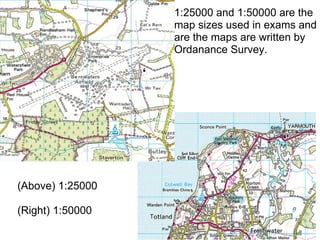
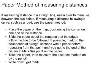
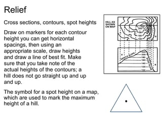
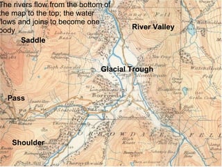
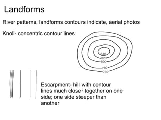
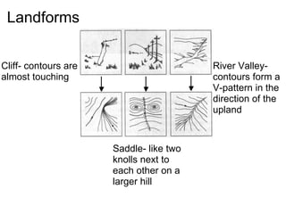
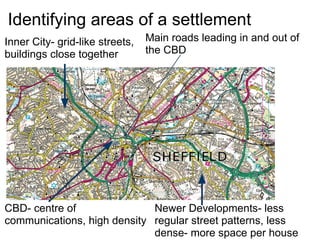
SlideShare a Scribd company logo
1 of 15
Mapwork
Specification ,[object Object],[object Object],[object Object],The 1:25000 scale is used on Pathfinder maps, the 1:50000 map is Landranger maps. 1:25000 means 1 cm = 250m, on a 1:50000 map 1cm = 500m.
Specification - Basic Skills Labelling and annotation of diagrams, maps, graphs, sketches etc. Drawing sketches from photographs and in the field. Literacy: most communication is through the written word raising the importance of good literacy skills. Photographs: candidates should be able to use and interpret aerial/ oblique and satellite photographs of rural and/or urban landscapes.
[object Object],[object Object],[object Object],Specification - Cartographic Skills
Scale and Direction Compasses, 4 figures, 6 figures, uses, scale, graph papers with distance measuring Three letter compass directions are rarely used, except in the most precise cases. It still helps to know the two letter compass points.
4 figure grid references generally used in questions where you have to describe what is in a general area, for example,  describe the features that can be seen in grid square 1844. 6 figure grid references are used to identify a specific point, for example,  what can be found at 187448?  6 figure grid references are also used when you are asked to draw the relief between 2 points
(Above) 1:25000   (Right) 1:50000 1:25000 and 1:50000 are the map sizes used in exams and are the maps are written by Ordanance Survey.
Paper Method of measuring distances If measuring distance in a straight line, use a ruler to measure between the two points. If measuring a distance following a curve, such as a road, use the paper method: ,[object Object],[object Object],[object Object],[object Object]
Relief ,[object Object],[object Object],[object Object],[object Object],[object Object],[object Object],[object Object],[object Object],[object Object],[object Object],[object Object],[object Object],[object Object],Draw on markers for each contour height you can get horizontal spacings, then using an appropriate scale, draw heights and draw a line of best fit. Make sure that you take note of the actual heights of the contours; a hill does not go straight up and up and up. 
Pass Glacial Trough River Valley Shoulder Saddle The rivers flow from the bottom of the map to the top; the water flows and joins to become one body 
Landforms ,[object Object],Knoll- concentric contour lines Escarpment- hill with contour lines much closer together on one side; one side steeper than another
Landforms Cliff- contours are almost touching Saddle- like two knolls next to each other on a larger hill River Valley- contours form a V-pattern in the direction of the upland
Drainage ,[object Object],[object Object],[object Object],[object Object]
Identifying factors for settlement ,[object Object],[object Object],[object Object]
Identifying areas of a settlement CBD- centre of communications, high density Inner City- grid-like streets, buildings close together Newer Developments- less regular street patterns, less dense- more space per house Main roads leading in and out of the CBD

More Related Content

What's hot (20)

Types and delineation of regions ppt
Types and delineation of regions pptTypes and delineation of regions ppt
Types and delineation of regions ppt
 
Types of map
Types of mapTypes of map
Types of map
 
Types of maps
Types of maps Types of maps
Types of maps
 
Topographic Maps Notes
Topographic Maps NotesTopographic Maps Notes
Topographic Maps Notes
 
Transport geography
Transport geographyTransport geography
Transport geography
 
Geography Skills: Scale
Geography Skills:  ScaleGeography Skills:  Scale
Geography Skills: Scale
 
Maps, cartography and significances
Maps, cartography and significancesMaps, cartography and significances
Maps, cartography and significances
 
Political Geography.pptx
Political Geography.pptxPolitical Geography.pptx
Political Geography.pptx
 
System approach in Geography
System approach in GeographySystem approach in Geography
System approach in Geography
 
Remote sensing: Accuracy Assesment
Remote sensing: Accuracy AssesmentRemote sensing: Accuracy Assesment
Remote sensing: Accuracy Assesment
 
Quantitative techniques in geography
Quantitative techniques in geographyQuantitative techniques in geography
Quantitative techniques in geography
 
Map Skills Revision
Map Skills RevisionMap Skills Revision
Map Skills Revision
 
Growth foci concept
Growth foci conceptGrowth foci concept
Growth foci concept
 
Fluvial depositional landform geomorphology
Fluvial depositional  landform geomorphologyFluvial depositional  landform geomorphology
Fluvial depositional landform geomorphology
 
Himalaya
HimalayaHimalaya
Himalaya
 
Datum
DatumDatum
Datum
 
Human geography -an outline
Human geography -an outlineHuman geography -an outline
Human geography -an outline
 
Application of GIS
Application of GISApplication of GIS
Application of GIS
 
Von thunen’s model of agricultural land use
Von thunen’s  model of agricultural land useVon thunen’s  model of agricultural land use
Von thunen’s model of agricultural land use
 
vulcanism
vulcanismvulcanism
vulcanism
 

Viewers also liked

Mapwork calculations
Mapwork calculationsMapwork calculations
Mapwork calculationsfenslin
 
Contours and geographical skills
Contours and geographical skillsContours and geographical skills
Contours and geographical skillslavenderbongo
 
IGCSE - Map Work Basics
IGCSE - Map Work BasicsIGCSE - Map Work Basics
IGCSE - Map Work BasicsEcumene
 
Contouring - Surveying...for civil Engineering and Architecture..
Contouring - Surveying...for civil Engineering and Architecture..Contouring - Surveying...for civil Engineering and Architecture..
Contouring - Surveying...for civil Engineering and Architecture..Pramesh Hada
 
Mapwork Basic Skills.ppt
Mapwork Basic Skills.pptMapwork Basic Skills.ppt
Mapwork Basic Skills.pptmarcguybrown
 
Secondary 1 Geography-Topographic Map
Secondary 1 Geography-Topographic MapSecondary 1 Geography-Topographic Map
Secondary 1 Geography-Topographic MapMarioSonic54
 
Class X ICSE Geography Solved Question Paper
Class X ICSE Geography Solved Question PaperClass X ICSE Geography Solved Question Paper
Class X ICSE Geography Solved Question PaperAtrayee SenGupta
 

Viewers also liked (12)

Mapwork calculations
Mapwork calculationsMapwork calculations
Mapwork calculations
 
Contours and geographical skills
Contours and geographical skillsContours and geographical skills
Contours and geographical skills
 
Contour diagrams
Contour diagramsContour diagrams
Contour diagrams
 
IGCSE - Map Work Basics
IGCSE - Map Work BasicsIGCSE - Map Work Basics
IGCSE - Map Work Basics
 
Contouring
ContouringContouring
Contouring
 
Gradient
GradientGradient
Gradient
 
Map & a diagram (1)
Map & a diagram (1)Map & a diagram (1)
Map & a diagram (1)
 
Contouring - Surveying...for civil Engineering and Architecture..
Contouring - Surveying...for civil Engineering and Architecture..Contouring - Surveying...for civil Engineering and Architecture..
Contouring - Surveying...for civil Engineering and Architecture..
 
Mapwork Basic Skills.ppt
Mapwork Basic Skills.pptMapwork Basic Skills.ppt
Mapwork Basic Skills.ppt
 
Secondary 1 Geography-Topographic Map
Secondary 1 Geography-Topographic MapSecondary 1 Geography-Topographic Map
Secondary 1 Geography-Topographic Map
 
Class X ICSE Geography Solved Question Paper
Class X ICSE Geography Solved Question PaperClass X ICSE Geography Solved Question Paper
Class X ICSE Geography Solved Question Paper
 
Types of Map Scales
Types of Map ScalesTypes of Map Scales
Types of Map Scales
 

Similar to Mapwork

Chapter 3 gateway 123
Chapter 3 gateway 123Chapter 3 gateway 123
Chapter 3 gateway 123MissST
 
Topographic maps presentation_mine
Topographic maps presentation_mineTopographic maps presentation_mine
Topographic maps presentation_minemisterbatroms
 
Chapter 3 gateway 123 combined
Chapter 3 gateway 123 combinedChapter 3 gateway 123 combined
Chapter 3 gateway 123 combinedMissST
 
Orienteering 101
Orienteering 101Orienteering 101
Orienteering 101rsintobin
 
Maps-and-map-interpretation.pdf
Maps-and-map-interpretation.pdfMaps-and-map-interpretation.pdf
Maps-and-map-interpretation.pdfshucaybcabdi
 
FCP 3 - Map Reading - CFSGT Putland - Mar 10
FCP 3 - Map Reading - CFSGT Putland - Mar 10FCP 3 - Map Reading - CFSGT Putland - Mar 10
FCP 3 - Map Reading - CFSGT Putland - Mar 10715 Squadron
 
Land Navigation Presentation
Land Navigation PresentationLand Navigation Presentation
Land Navigation PresentationWilliam Perkins
 
map reading unit 1.pdf
map reading unit 1.pdfmap reading unit 1.pdf
map reading unit 1.pdfwarkisafile1
 
Topographic maps for UDL lesson
Topographic maps for UDL lessonTopographic maps for UDL lesson
Topographic maps for UDL lessonrbritton24
 
Topographic maps for UDL lesson
Topographic maps for UDL lessonTopographic maps for UDL lesson
Topographic maps for UDL lessonrbritton24
 
About Topgrapic Map Details & know how to study topograpic map.
About Topgrapic Map Details & know how to study topograpic map.About Topgrapic Map Details & know how to study topograpic map.
About Topgrapic Map Details & know how to study topograpic map.Shahid Hussain
 
Topographic Map
Topographic MapTopographic Map
Topographic Mapmjcnavarro
 
Map work for geography for CSEC from NIGFC
Map work for geography for CSEC from NIGFCMap work for geography for CSEC from NIGFC
Map work for geography for CSEC from NIGFCmaliquehodge
 

Similar to Mapwork (20)

Chapter 3 gateway 123
Chapter 3 gateway 123Chapter 3 gateway 123
Chapter 3 gateway 123
 
Topographic maps presentation_mine
Topographic maps presentation_mineTopographic maps presentation_mine
Topographic maps presentation_mine
 
Chapter 3 gateway 123 combined
Chapter 3 gateway 123 combinedChapter 3 gateway 123 combined
Chapter 3 gateway 123 combined
 
Orienteering 101
Orienteering 101Orienteering 101
Orienteering 101
 
Toposheet interpretation
Toposheet interpretationToposheet interpretation
Toposheet interpretation
 
Maps-and-map-interpretation.pdf
Maps-and-map-interpretation.pdfMaps-and-map-interpretation.pdf
Maps-and-map-interpretation.pdf
 
FCP 3 - Map Reading - CFSGT Putland - Mar 10
FCP 3 - Map Reading - CFSGT Putland - Mar 10FCP 3 - Map Reading - CFSGT Putland - Mar 10
FCP 3 - Map Reading - CFSGT Putland - Mar 10
 
Land Navigation Presentation
Land Navigation PresentationLand Navigation Presentation
Land Navigation Presentation
 
Mapping
MappingMapping
Mapping
 
map reading unit 1.pdf
map reading unit 1.pdfmap reading unit 1.pdf
map reading unit 1.pdf
 
Topographic maps for UDL lesson
Topographic maps for UDL lessonTopographic maps for UDL lesson
Topographic maps for UDL lesson
 
Topographic maps for UDL lesson
Topographic maps for UDL lessonTopographic maps for UDL lesson
Topographic maps for UDL lesson
 
Topo maps
Topo mapsTopo maps
Topo maps
 
Topographic maps
Topographic mapsTopographic maps
Topographic maps
 
About Topgrapic Map Details & know how to study topograpic map.
About Topgrapic Map Details & know how to study topograpic map.About Topgrapic Map Details & know how to study topograpic map.
About Topgrapic Map Details & know how to study topograpic map.
 
Topographic Map
Topographic MapTopographic Map
Topographic Map
 
Contouring
ContouringContouring
Contouring
 
GEOGRAPHY IGCSE: MAP SKILLS
GEOGRAPHY IGCSE: MAP SKILLSGEOGRAPHY IGCSE: MAP SKILLS
GEOGRAPHY IGCSE: MAP SKILLS
 
Map work for geography for CSEC from NIGFC
Map work for geography for CSEC from NIGFCMap work for geography for CSEC from NIGFC
Map work for geography for CSEC from NIGFC
 
Unit 2 Elements of a map.pdf
Unit 2 Elements of a map.pdfUnit 2 Elements of a map.pdf
Unit 2 Elements of a map.pdf
 

More from Keith Phipps

Keeping children safe_in_education_part_1_only
Keeping children safe_in_education_part_1_onlyKeeping children safe_in_education_part_1_only
Keeping children safe_in_education_part_1_onlyKeith Phipps
 
Transition by Emma Lamb
Transition by Emma LambTransition by Emma Lamb
Transition by Emma LambKeith Phipps
 
Widening Access by Giles Hill
Widening Access by Giles HillWidening Access by Giles Hill
Widening Access by Giles HillKeith Phipps
 
Maths primary cpd andrew rogers
Maths primary cpd andrew rogersMaths primary cpd andrew rogers
Maths primary cpd andrew rogersKeith Phipps
 
Reading 4 – writing links and encouraging wider reading
Reading 4 – writing links and encouraging wider readingReading 4 – writing links and encouraging wider reading
Reading 4 – writing links and encouraging wider readingKeith Phipps
 
Reading 3 – writing links and encouraging wider reading
Reading 3 – writing links and encouraging wider readingReading 3 – writing links and encouraging wider reading
Reading 3 – writing links and encouraging wider readingKeith Phipps
 
Reading 2 – writing links and encouraging wider reading
Reading 2 – writing links and encouraging wider readingReading 2 – writing links and encouraging wider reading
Reading 2 – writing links and encouraging wider readingKeith Phipps
 
Reading 1 – writing links and encouraging wider reading
Reading 1 – writing links and encouraging wider readingReading 1 – writing links and encouraging wider reading
Reading 1 – writing links and encouraging wider readingKeith Phipps
 
Parent presentation
Parent presentationParent presentation
Parent presentationKeith Phipps
 
C:\Fakepath\Lower Sixth Information Evening 2010
C:\Fakepath\Lower Sixth Information Evening 2010C:\Fakepath\Lower Sixth Information Evening 2010
C:\Fakepath\Lower Sixth Information Evening 2010Keith Phipps
 
C:\Fakepath\Open Day 2010
C:\Fakepath\Open Day 2010C:\Fakepath\Open Day 2010
C:\Fakepath\Open Day 2010Keith Phipps
 
Mapwork Revision Guide final
Mapwork Revision Guide finalMapwork Revision Guide final
Mapwork Revision Guide finalKeith Phipps
 

More from Keith Phipps (20)

Keeping children safe_in_education_part_1_only
Keeping children safe_in_education_part_1_onlyKeeping children safe_in_education_part_1_only
Keeping children safe_in_education_part_1_only
 
Transition by Emma Lamb
Transition by Emma LambTransition by Emma Lamb
Transition by Emma Lamb
 
Widening Access by Giles Hill
Widening Access by Giles HillWidening Access by Giles Hill
Widening Access by Giles Hill
 
Maths primary cpd andrew rogers
Maths primary cpd andrew rogersMaths primary cpd andrew rogers
Maths primary cpd andrew rogers
 
Reading 4 – writing links and encouraging wider reading
Reading 4 – writing links and encouraging wider readingReading 4 – writing links and encouraging wider reading
Reading 4 – writing links and encouraging wider reading
 
Reading 3 – writing links and encouraging wider reading
Reading 3 – writing links and encouraging wider readingReading 3 – writing links and encouraging wider reading
Reading 3 – writing links and encouraging wider reading
 
Reading 2 – writing links and encouraging wider reading
Reading 2 – writing links and encouraging wider readingReading 2 – writing links and encouraging wider reading
Reading 2 – writing links and encouraging wider reading
 
Reading 1 – writing links and encouraging wider reading
Reading 1 – writing links and encouraging wider readingReading 1 – writing links and encouraging wider reading
Reading 1 – writing links and encouraging wider reading
 
Parent presentation
Parent presentationParent presentation
Parent presentation
 
French cpd1
French cpd1French cpd1
French cpd1
 
Web 2.0
Web 2.0 Web 2.0
Web 2.0
 
The Ucas Process
The Ucas ProcessThe Ucas Process
The Ucas Process
 
C:\Fakepath\Lower Sixth Information Evening 2010
C:\Fakepath\Lower Sixth Information Evening 2010C:\Fakepath\Lower Sixth Information Evening 2010
C:\Fakepath\Lower Sixth Information Evening 2010
 
C:\Fakepath\Open Day 2010
C:\Fakepath\Open Day 2010C:\Fakepath\Open Day 2010
C:\Fakepath\Open Day 2010
 
Group Rivers
Group RiversGroup Rivers
Group Rivers
 
Industry
IndustryIndustry
Industry
 
Coasts
CoastsCoasts
Coasts
 
Development
DevelopmentDevelopment
Development
 
Glaciation
GlaciationGlaciation
Glaciation
 
Mapwork Revision Guide final
Mapwork Revision Guide finalMapwork Revision Guide final
Mapwork Revision Guide final
 

Mapwork

  • 2.
  • 3. Specification - Basic Skills Labelling and annotation of diagrams, maps, graphs, sketches etc. Drawing sketches from photographs and in the field. Literacy: most communication is through the written word raising the importance of good literacy skills. Photographs: candidates should be able to use and interpret aerial/ oblique and satellite photographs of rural and/or urban landscapes.
  • 4.
  • 5. Scale and Direction Compasses, 4 figures, 6 figures, uses, scale, graph papers with distance measuring Three letter compass directions are rarely used, except in the most precise cases. It still helps to know the two letter compass points.
  • 6. 4 figure grid references generally used in questions where you have to describe what is in a general area, for example, describe the features that can be seen in grid square 1844. 6 figure grid references are used to identify a specific point, for example, what can be found at 187448? 6 figure grid references are also used when you are asked to draw the relief between 2 points
  • 7. (Above) 1:25000   (Right) 1:50000 1:25000 and 1:50000 are the map sizes used in exams and are the maps are written by Ordanance Survey.
  • 8.
  • 9.
  • 10. Pass Glacial Trough River Valley Shoulder Saddle The rivers flow from the bottom of the map to the top; the water flows and joins to become one body 
  • 11.
  • 12. Landforms Cliff- contours are almost touching Saddle- like two knolls next to each other on a larger hill River Valley- contours form a V-pattern in the direction of the upland
  • 13.
  • 14.
  • 15. Identifying areas of a settlement CBD- centre of communications, high density Inner City- grid-like streets, buildings close together Newer Developments- less regular street patterns, less dense- more space per house Main roads leading in and out of the CBD