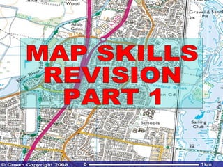
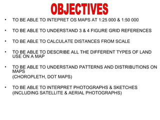
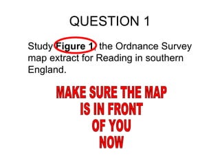
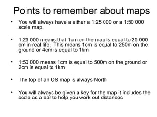
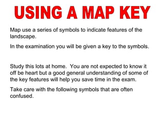
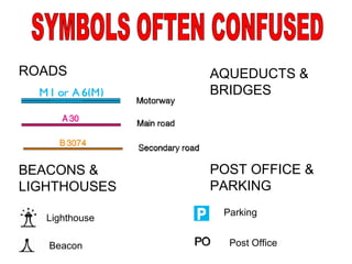
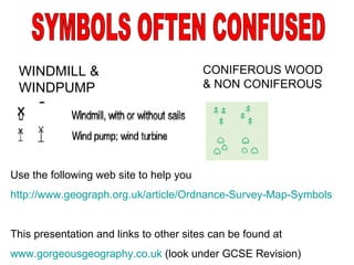
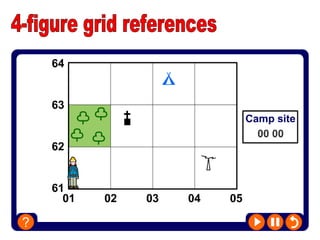
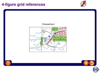
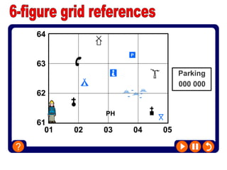
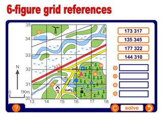
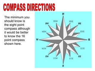
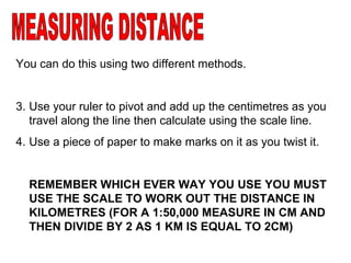
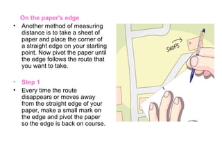
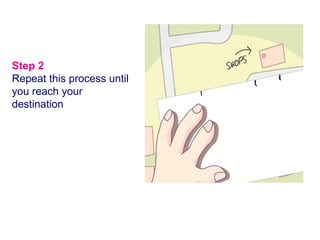
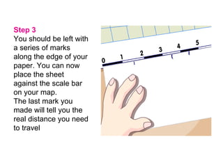
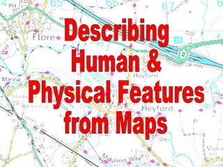
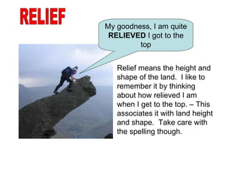
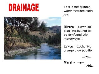
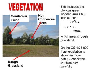
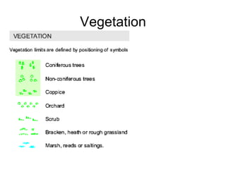
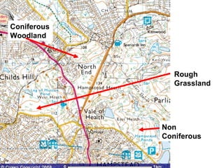
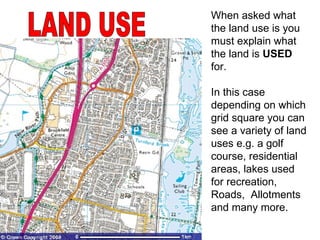
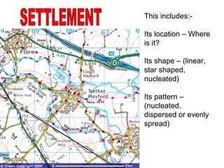
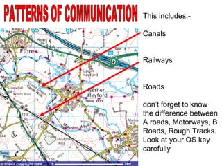
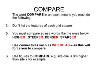
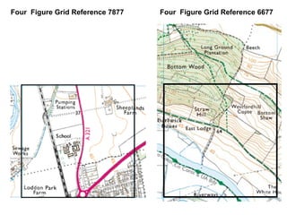
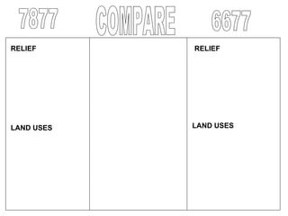
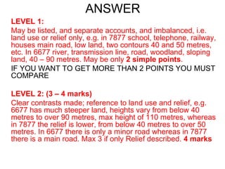
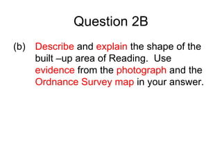
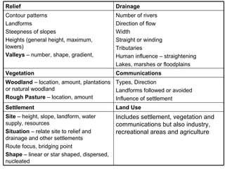
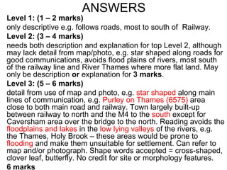
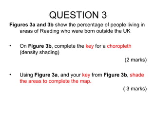
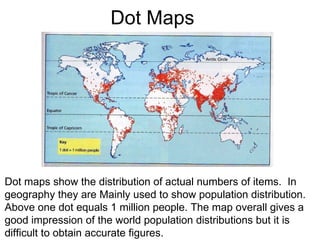
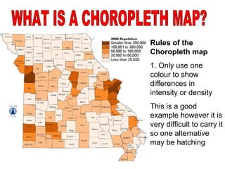
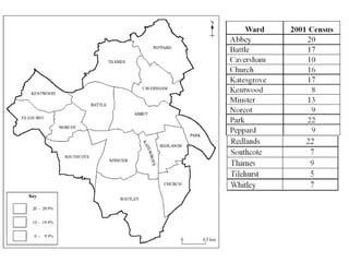
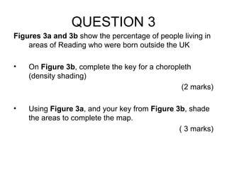
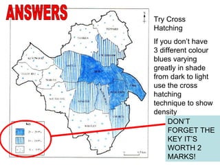
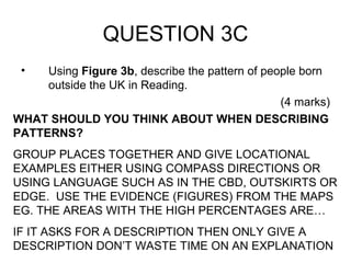
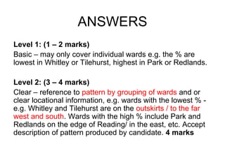
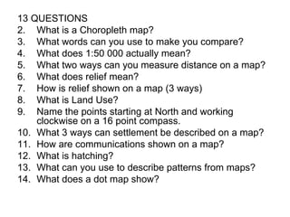
This document provides revision material for map skills. It covers topics such as understanding map scales, grid references, measuring distances, interpreting relief, land use, settlement patterns, and different types of maps including choropleth, dot maps and aerial photographs. Students are advised on techniques for answering exam questions that require comparing locations and describing patterns and distributions visible on maps.
By the end of the lesson students should be able to:
-explain how height is shown on maps
-recognise slope types
-some will identify landscape features from looking at contours
Indexing of toposheets, in Introduction to Million sheet, degree sheet, toposheet, and their scales.
Some practice questions based on toposheet indexing and map scale has also been given for best practice.
It will give you a fundamentals on different types of map and an introduction on topographic mapping.
This presentation is made for my report in Basic Geography Class
3.0 Project 2_ Developing My Brand Identity Kit.pptxtanyjahb
A personal brand exploration presentation summarizes an individual's unique qualities and goals, covering strengths, values, passions, and target audience. It helps individuals understand what makes them stand out, their desired image, and how they aim to achieve it.
Company Valuation webinar series - Tuesday, 4 June 2024FelixPerez547899
This session provided an update as to the latest valuation data in the UK and then delved into a discussion on the upcoming election and the impacts on valuation. We finished, as always with a Q&A
Navigating the world of forex trading can be challenging, especially for beginners. To help you make an informed decision, we have comprehensively compared the best forex brokers in India for 2024. This article, reviewed by Top Forex Brokers Review, will cover featured award winners, the best forex brokers, featured offers, the best copy trading platforms, the best forex brokers for beginners, the best MetaTrader brokers, and recently updated reviews. We will focus on FP Markets, Black Bull, EightCap, IC Markets, and Octa.
FIA officials brutally tortured innocent and snatched 200 Bitcoins of worth 4...jamalseoexpert1978
Farman Ayaz Khattak and Ehtesham Matloob are government officials in CTW Counter terrorism wing Islamabad, in Federal Investigation Agency FIA Headquarters. CTW and FIA kidnapped crypto currency owner from Islamabad and snatched 200 Bitcoins those worth of 4 billion rupees in Pakistan currency. There is not Cryptocurrency Regulations in Pakistan & CTW is official dacoit and stealing digital assets from the innocent crypto holders and making fake cases of terrorism to keep them silent.
At Techbox Square, in Singapore, we're not just creative web designers and developers, we're the driving force behind your brand identity. Contact us today.
Recruiting in the Digital Age: A Social Media MasterclassLuanWise
In this masterclass, presented at the Global HR Summit on 5th June 2024, Luan Wise explored the essential features of social media platforms that support talent acquisition, including LinkedIn, Facebook, Instagram, X (formerly Twitter) and TikTok.
B2B payments are rapidly changing. Find out the 5 key questions you need to be asking yourself to be sure you are mastering B2B payments today. Learn more at www.BlueSnap.com.
buy old yahoo accounts buy yahoo accountsSusan Laney
As a business owner, I understand the importance of having a strong online presence and leveraging various digital platforms to reach and engage with your target audience. One often overlooked yet highly valuable asset in this regard is the humble Yahoo account. While many may perceive Yahoo as a relic of the past, the truth is that these accounts still hold immense potential for businesses of all sizes.
Top mailing list providers in the USA.pptxJeremyPeirce1
Discover the top mailing list providers in the USA, offering targeted lists, segmentation, and analytics to optimize your marketing campaigns and drive engagement.
6. USING A MAP KEY Map use a series of symbols to indicate features of the landscape. In the examination you will be given a key to the symbols. Study this lots at home. You are not expected to know it off be heart but a good general understanding of some of the key features will help you save time in the exam. Take care with the following symbols that are often confused.
14. COMPASS DIRECTIONS The minimum you should know is the eight point compass although it would be better to know the 16 point compass shown here.
15.
16.
17. Step 2 Repeat this process until you reach your destination
18. Step 3 You should be left with a series of marks along the edge of your paper. You can now place the sheet against the scale bar on your map. The last mark you made will tell you the real distance you need to travel
20. RELIEF My goodness, I am quite RELIEVED I got to the top Relief means the height and shape of the land. I like to remember it by thinking about how relieved I am when I get to the top. – This associates it with land height and shape. Take care with the spelling though.
21. DRAINAGE This is the surface water features such as:- Rivers – drawn as blue line but not to be confused with motorways!!! Lakes – Looks like a large blue puddle Marsh-
22. VEGETATION This includes the obvious green wooded areas but look out for which means rough grassland. On the OS 1:25 000 map vegetation is shown in more detail – check the symbols key carefully Rough Grassland Coniferous Trees Non Coniferous Trees
25. LAND USE When asked what the land use is you must explain what the land is USED for. In this case depending on which grid square you can see a variety of land uses e.g. a golf course, residential areas, lakes used for recreation, Roads, Allotments and many more.
26. SETTLEMENT This includes:- Its location – Where is it? Its shape – (linear, star shaped, nucleated) Its pattern – (nucleated, dispersed or evenly spread)
27. PATTERNS OF COMMUNICATION This includes:- Canals Railways Roads don’t forget to know the difference between A roads, Motorways, B Roads, Rough Tracks. Look at your OS key carefully
34. ANALYSING AERIAL PHOTOGRAPHS As well as Ordnance Survey maps you will also be given a photograph of part of the area shown on an OS map. The first thing to do is make sure you orientate your photograph correctly so you know exactly which part of the map is shown. Lets do this now for Reading What are the key points to look at?
35. Y X Z Look for key features on the map to find out where it is on the OS map then use the OS map to identify the features. For this example the stadium is easy to see as is the roads and shape of the fields
36.
37.
38. A CHECK LIST TO HELP YOU TO DESCRIBE FEATURES ON A MAP
39. Includes settlement, vegetation and communications but also industry, recreational areas and agriculture Site – height, slope, landform, water supply, resources Situation – relate site to relief and drainage and other settlements Route focus, bridging point Shape – linear or star shaped, dispersed, nucleated Land Use Settlement Types, Direction Landforms followed or avoided Influence of settlement Woodland – location, amount, plantations or natural woodland Rough Pasture – location, amount Communications Vegetation Number of rivers Direction of flow Width Straight or winding Tributaries Human influence – straightening Lakes, marshes or floodplains Contour patterns Landforms Steepness of slopes Heights (general height, maximum, lowers) Valleys – number, shape, gradient, Drainage Relief
43. Dot Maps Dot maps show the distribution of actual numbers of items. In geography they are Mainly used to show population distribution. Above one dot equals 1 million people. The map overall gives a good impression of the world population distributions but it is difficult to obtain accurate figures.
44. Rules of the Choropleth map 1. Only use one colour to show differences in intensity or density This is a good example however it is very difficult to carry it so one alternative may be hatching WHAT IS A CHOROPLETH MAP?
45.
46.
47. Try Cross Hatching If you don’t have 3 different colour blues varying greatly in shade from dark to light use the cross hatching technique to show density ANSWERS DON’T FORGET THE KEY IT’S WORTH 2 MARKS!