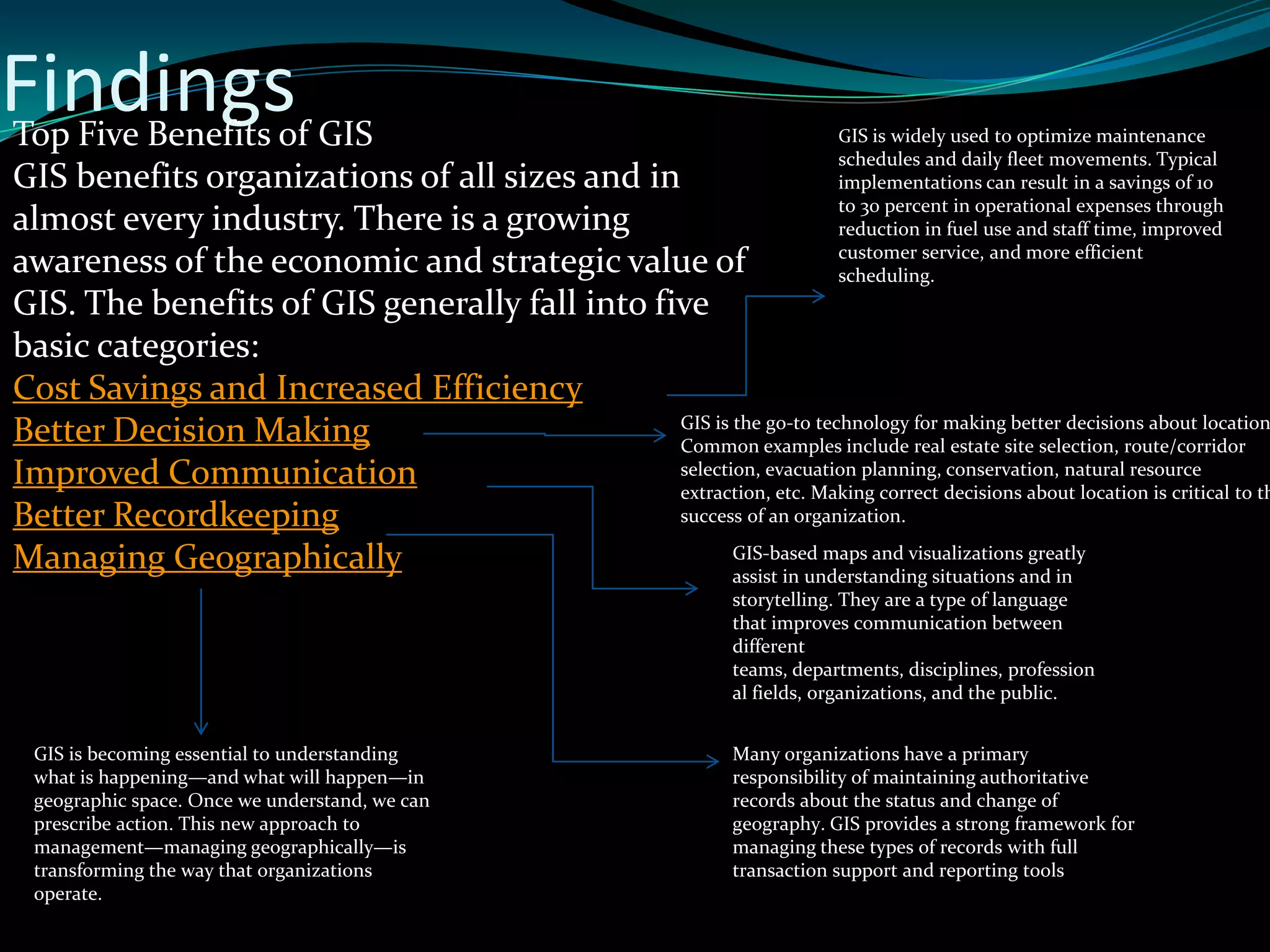
Learning Assignment on
Geographic Information
SYSTEM
Presented
By
 M TAHIR MEHMOOD (1019)
 M FURQAN RAUF (1067)
 ALI RAZA (1066)
BS(IT) MORNING
Geographic Information
Systems(GIS)
 Definition
 Introduction
 Functional Parts
 People Role
 Information Flow
 Finding
 Summary
 Conclusions
Geographic Information
Systems(GIS)
 A geographic information system (GIS) integrates hardware, software, and data
for capturing, managing, analyzing, and displaying all forms of geographically
referenced information.
 GIS allows us to view, understand, question, interpret, and visualize data in
many ways that reveal relationships, patterns, and trends in the form of
maps, globes, reports, and charts.
 A GIS helps you answer questions and solve problems by looking at your data in
a way that is quickly understood and easily shared.
 GIS technology can be integrated into any enterprise information system
framework
 GIS is a relatively new field — it started in the 1970’s. It used to be
that computerised GIS was only available to companies and
universities that had expensive computer equipment. These days,
anyone with a personal computer or laptop can use GIS software.
Over time GIS Applications have also become easier to use –– it
used to require a lot of training to use a GIS Application, but now
it is much easier to get started in GIS even for amateurs and casual
users. As we described above, GIS is more than just software, it
refers to all aspects of managing and using digital geographical
data. In the tutorials that follow we will be focusing on GIS
Software.
Technologies Used In (GIS)
 Modern GIS technologies use digital information, for which various digitized data
creation methods are used. The most common method of data creation is
digitization, where a hard copy map or survey plan is transferred into a digital medium
through the use of a CAD program, and geo-referencing capabilities. With the wide
availability of ortho-rectified imagery (both from satellite and aerial sources), heads-up
digitizing is becoming the main avenue through which geographic data is extracted.
Heads-up digitizing involves the tracing of geographic data directly on top of the aerial
imagery instead of by the traditional method of tracing the geographic form on a
separatedigitizing tablet (heads-down digitizing).
GIS allows multiple layers of
information to be displayed on a single
map.
GIS components
6
Specific applications /
decision making objectives
?
G I S
Spatial
data
Computer hardware /
software tools
SPATIAL Data
Information referenced by its
location in space
Computer Hardware ––
computers used for storing
data, displaying graphics and
processing data.
Computer Software ––
computer programs that run on
the computer hardware and
allow you to work with digital
data. A software program that
forms part of the GIS is called a
GIS Application.
Functional Parts
What can We Do with GIS?
Information Flow In GIS
FindingsTop Five Benefits of GIS
GIS benefits organizations of all sizes and in
almost every industry. There is a growing
awareness of the economic and strategic value of
GIS. The benefits of GIS generally fall into five
basic categories:
Cost Savings and Increased Efficiency
Better Decision Making
Improved Communication
Better Recordkeeping
Managing Geographically
GIS is widely used to optimize maintenance
schedules and daily fleet movements. Typical
implementations can result in a savings of 10
to 30 percent in operational expenses through
reduction in fuel use and staff time, improved
customer service, and more efficient
scheduling.
GIS is the go-to technology for making better decisions about location
Common examples include real estate site selection, route/corridor
selection, evacuation planning, conservation, natural resource
extraction, etc. Making correct decisions about location is critical to th
success of an organization.
GIS-based maps and visualizations greatly
assist in understanding situations and in
storytelling. They are a type of language
that improves communication between
different
teams, departments, disciplines, profession
al fields, organizations, and the public.
Many organizations have a primary
responsibility of maintaining authoritative
records about the status and change of
geography. GIS provides a strong framework for
managing these types of records with full
transaction support and reporting tools
GIS is becoming essential to understanding
what is happening—and what will happen—in
geographic space. Once we understand, we can
prescribe action. This new approach to
management—managing geographically—is
transforming the way that organizations
operate.
SUMMARY
Geography is the science of our world. Coupled with GIS, geography is helping us to
better understand the earth and apply geographic knowledge to a host of human
activities. The outcome is the emergence of The Geographic Approach—a new way of
thinking and problem solving that integrates geographic information into how we
understand and manage our planet. This approach allows us to create geographic
knowledge by measuring the earth, organizing this data, and analyzing and modeling
various processes and their relationships. The Geographic Approach also allows us to
apply this knowledge to the way we design, plan, and change our world.
Step 1: Ask
Step 2: Acquire
After clearly defining the problem, it is necessary to
determine the data needed to complete your analysis and
ascertain where that data can be found or generated. The
type of data and the geographic scope of your project will
help direct your methods of collecting data and conducting
the analysis.
Step 3: Examine
You will not know for certain whether the data you have acquired is
appropriate for your study until you thoroughly examine it. This
includes visual inspection, as well as investigating how the data is
organized (its schema), how well the data corresponds to other
datasets and the rules of the physical world (its topology), and the
story of where the data came from (its metadata).
Step 4: Analyze
The data is processed and analyzed based on the method of
examination or analysis you choose, which is dependent on
the results you hope to achieve. Do not underestimate the
power of "eyeballing" the data
Step 5: Act
Approaching a problem geographically involves framing the question from a location-based perspective.
What is the problem you are trying to solve or analyze, and where is it locate
The results and presentation of the analysis are important parts of The Geographic Approach. The
results can be shared through reports, maps, tables, and charts and delivered in printed form or
digitally over a network or on the Web.
CONCLUSION
• Numerous opportunities exist to learn GIS technology skills and
stay current with best practices.
• Whether you are new to GIS or a seasoned GIS
professional, proper education and training are essential to your
success.
• A variety of degree and certificate programs are available all
over the world.
• GIS software training is available in formal
classroom and online/distance programs, or you can choose
to learn GIS on your own time.
Future Scope
Reference
 http://www.esri.com/what-is-gis
 http://wikipedia.org/wiki/Geographic_information
_system
 http://Slideshare.net
 http://www.colorado.edu/geography
Thank
You

Learning assignment on geographic information system

  • 1.
    Learning Assignment on GeographicInformation SYSTEM Presented By  M TAHIR MEHMOOD (1019)  M FURQAN RAUF (1067)  ALI RAZA (1066) BS(IT) MORNING
  • 2.
    Geographic Information Systems(GIS)  Definition Introduction  Functional Parts  People Role  Information Flow  Finding  Summary  Conclusions
  • 3.
    Geographic Information Systems(GIS)  Ageographic information system (GIS) integrates hardware, software, and data for capturing, managing, analyzing, and displaying all forms of geographically referenced information.  GIS allows us to view, understand, question, interpret, and visualize data in many ways that reveal relationships, patterns, and trends in the form of maps, globes, reports, and charts.  A GIS helps you answer questions and solve problems by looking at your data in a way that is quickly understood and easily shared.  GIS technology can be integrated into any enterprise information system framework
  • 4.
     GIS isa relatively new field — it started in the 1970’s. It used to be that computerised GIS was only available to companies and universities that had expensive computer equipment. These days, anyone with a personal computer or laptop can use GIS software. Over time GIS Applications have also become easier to use –– it used to require a lot of training to use a GIS Application, but now it is much easier to get started in GIS even for amateurs and casual users. As we described above, GIS is more than just software, it refers to all aspects of managing and using digital geographical data. In the tutorials that follow we will be focusing on GIS Software.
  • 5.
    Technologies Used In(GIS)  Modern GIS technologies use digital information, for which various digitized data creation methods are used. The most common method of data creation is digitization, where a hard copy map or survey plan is transferred into a digital medium through the use of a CAD program, and geo-referencing capabilities. With the wide availability of ortho-rectified imagery (both from satellite and aerial sources), heads-up digitizing is becoming the main avenue through which geographic data is extracted. Heads-up digitizing involves the tracing of geographic data directly on top of the aerial imagery instead of by the traditional method of tracing the geographic form on a separatedigitizing tablet (heads-down digitizing). GIS allows multiple layers of information to be displayed on a single map.
  • 6.
    GIS components 6 Specific applications/ decision making objectives ? G I S Spatial data Computer hardware / software tools SPATIAL Data Information referenced by its location in space Computer Hardware –– computers used for storing data, displaying graphics and processing data. Computer Software –– computer programs that run on the computer hardware and allow you to work with digital data. A software program that forms part of the GIS is called a GIS Application. Functional Parts
  • 7.
    What can WeDo with GIS?
  • 8.
  • 9.
    FindingsTop Five Benefitsof GIS GIS benefits organizations of all sizes and in almost every industry. There is a growing awareness of the economic and strategic value of GIS. The benefits of GIS generally fall into five basic categories: Cost Savings and Increased Efficiency Better Decision Making Improved Communication Better Recordkeeping Managing Geographically GIS is widely used to optimize maintenance schedules and daily fleet movements. Typical implementations can result in a savings of 10 to 30 percent in operational expenses through reduction in fuel use and staff time, improved customer service, and more efficient scheduling. GIS is the go-to technology for making better decisions about location Common examples include real estate site selection, route/corridor selection, evacuation planning, conservation, natural resource extraction, etc. Making correct decisions about location is critical to th success of an organization. GIS-based maps and visualizations greatly assist in understanding situations and in storytelling. They are a type of language that improves communication between different teams, departments, disciplines, profession al fields, organizations, and the public. Many organizations have a primary responsibility of maintaining authoritative records about the status and change of geography. GIS provides a strong framework for managing these types of records with full transaction support and reporting tools GIS is becoming essential to understanding what is happening—and what will happen—in geographic space. Once we understand, we can prescribe action. This new approach to management—managing geographically—is transforming the way that organizations operate.
  • 10.
    SUMMARY Geography is thescience of our world. Coupled with GIS, geography is helping us to better understand the earth and apply geographic knowledge to a host of human activities. The outcome is the emergence of The Geographic Approach—a new way of thinking and problem solving that integrates geographic information into how we understand and manage our planet. This approach allows us to create geographic knowledge by measuring the earth, organizing this data, and analyzing and modeling various processes and their relationships. The Geographic Approach also allows us to apply this knowledge to the way we design, plan, and change our world.
  • 11.
    Step 1: Ask Step2: Acquire After clearly defining the problem, it is necessary to determine the data needed to complete your analysis and ascertain where that data can be found or generated. The type of data and the geographic scope of your project will help direct your methods of collecting data and conducting the analysis. Step 3: Examine You will not know for certain whether the data you have acquired is appropriate for your study until you thoroughly examine it. This includes visual inspection, as well as investigating how the data is organized (its schema), how well the data corresponds to other datasets and the rules of the physical world (its topology), and the story of where the data came from (its metadata). Step 4: Analyze The data is processed and analyzed based on the method of examination or analysis you choose, which is dependent on the results you hope to achieve. Do not underestimate the power of "eyeballing" the data Step 5: Act Approaching a problem geographically involves framing the question from a location-based perspective. What is the problem you are trying to solve or analyze, and where is it locate The results and presentation of the analysis are important parts of The Geographic Approach. The results can be shared through reports, maps, tables, and charts and delivered in printed form or digitally over a network or on the Web.
  • 12.
    CONCLUSION • Numerous opportunitiesexist to learn GIS technology skills and stay current with best practices. • Whether you are new to GIS or a seasoned GIS professional, proper education and training are essential to your success. • A variety of degree and certificate programs are available all over the world. • GIS software training is available in formal classroom and online/distance programs, or you can choose to learn GIS on your own time.
  • 13.
  • 14.
  • 15.