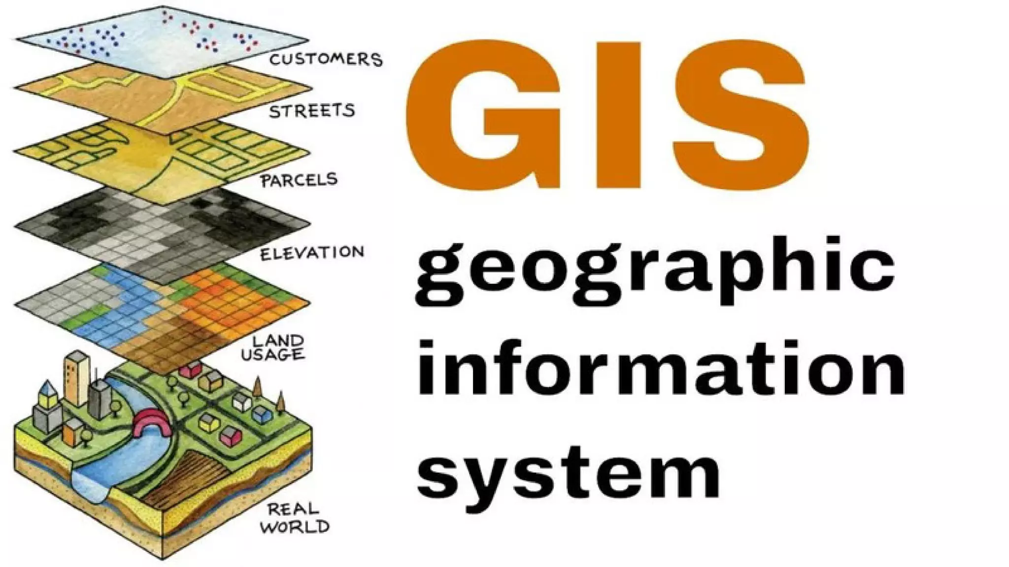
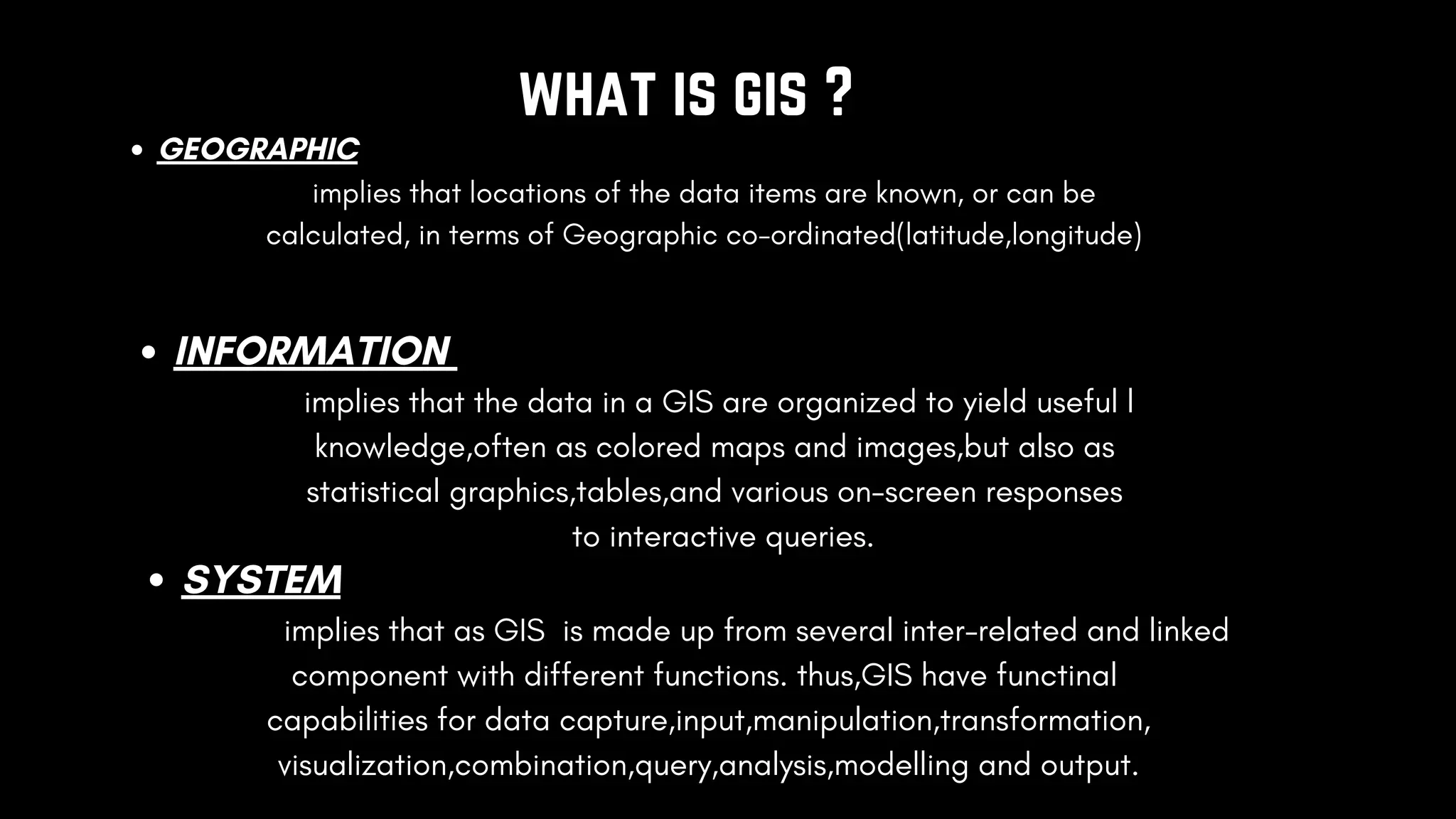
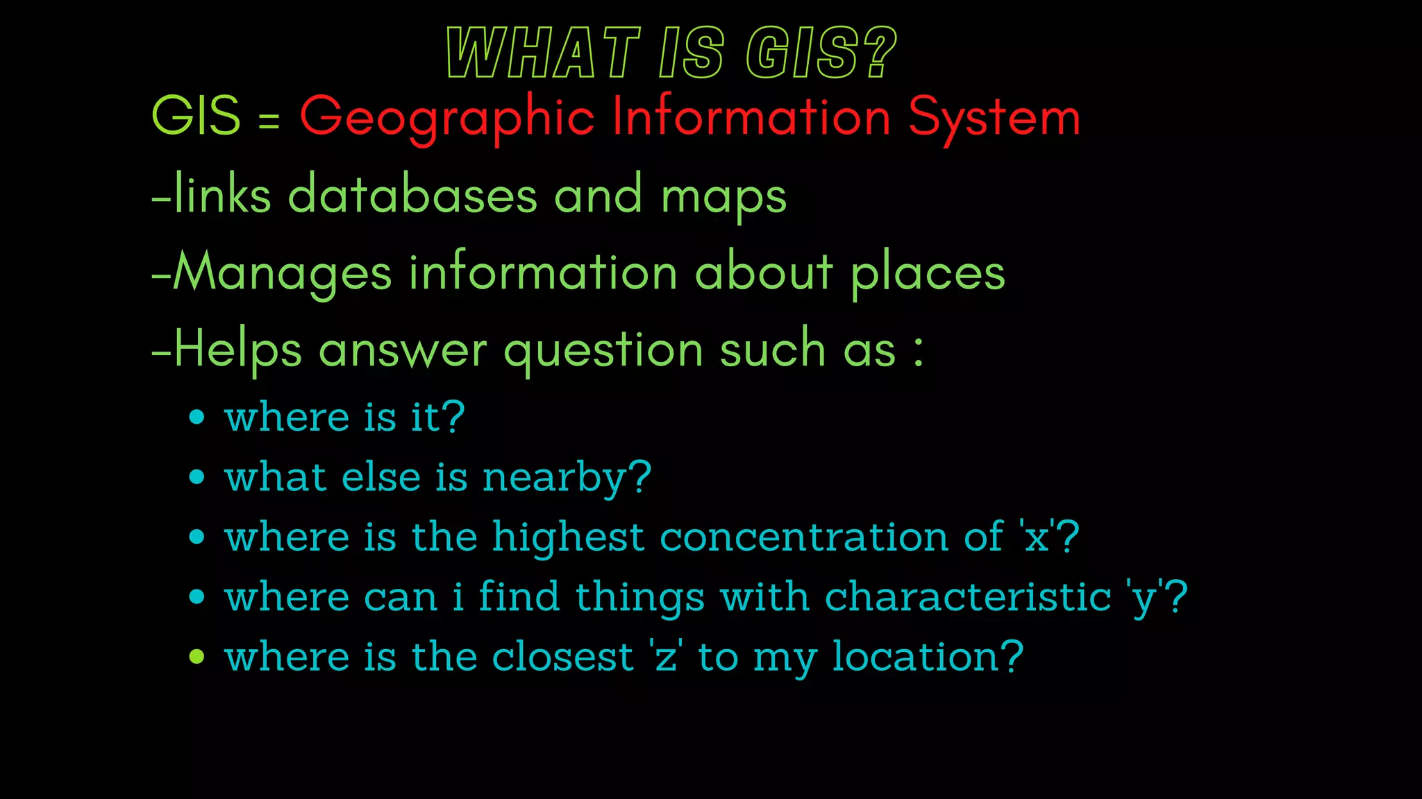
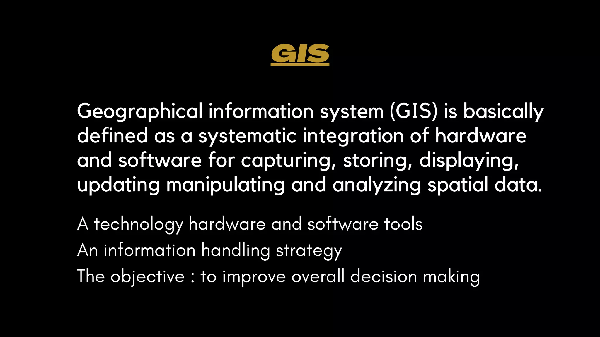
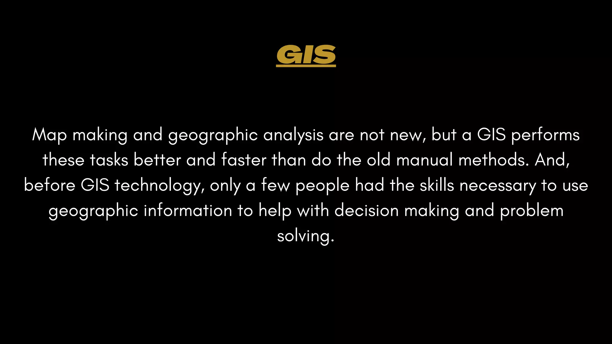
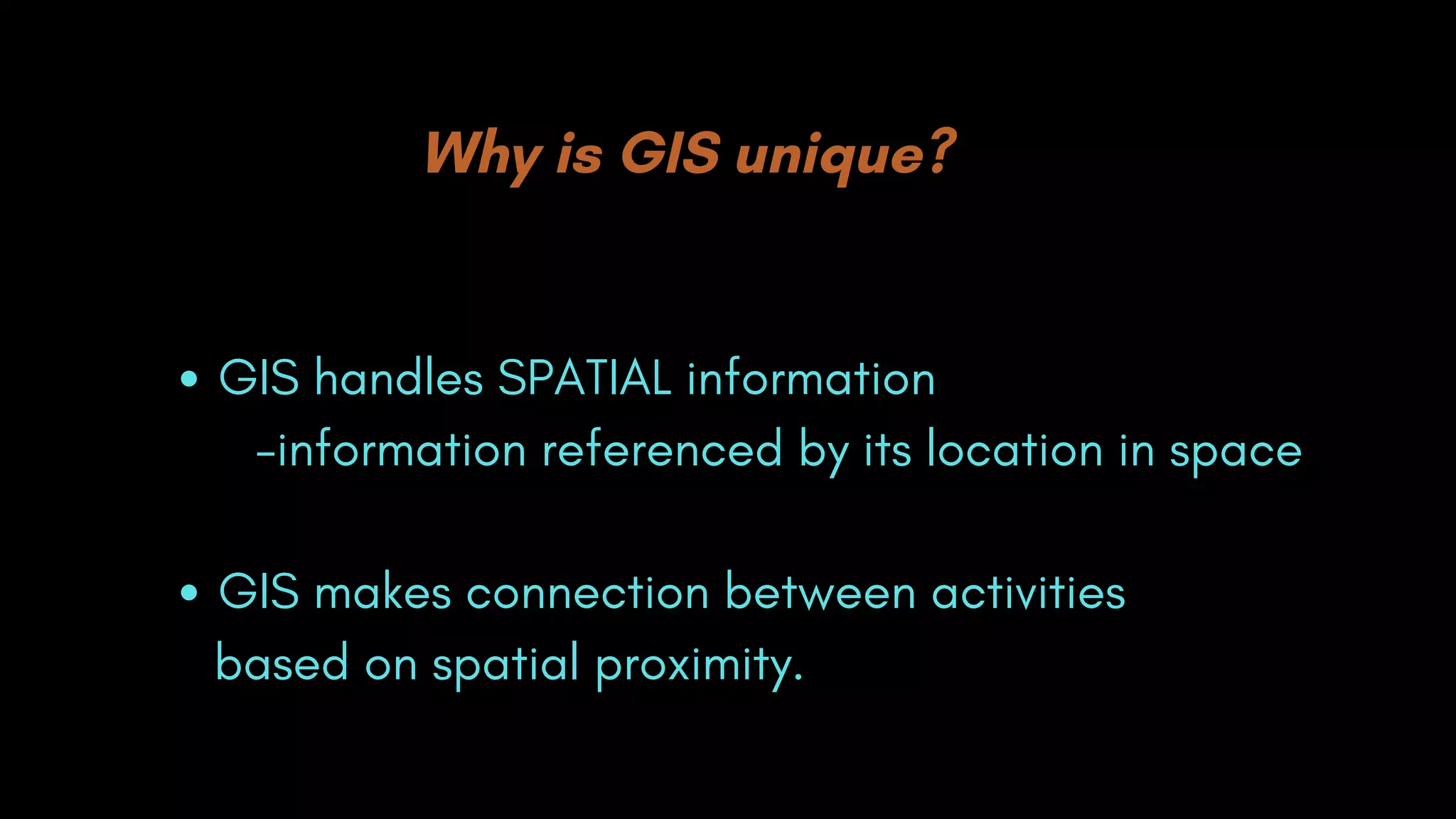
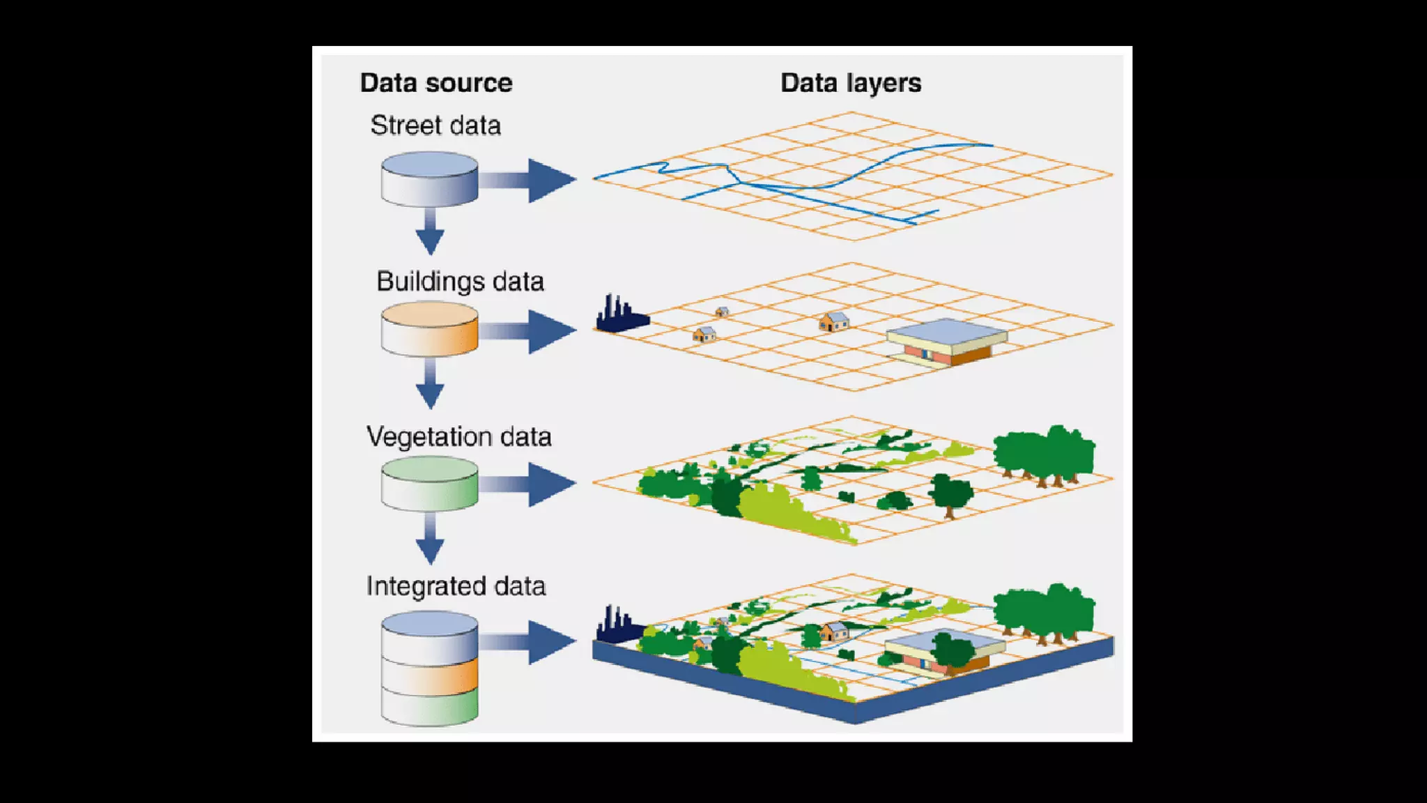
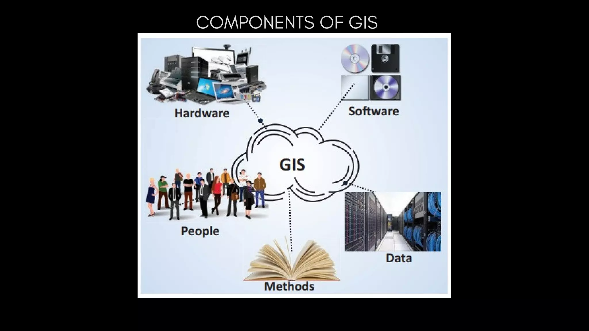
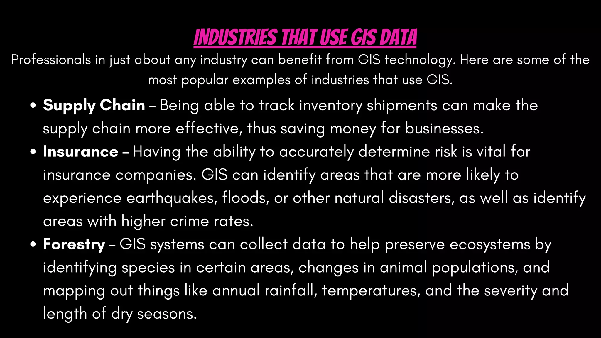
SlideShare a Scribd company logo
GEOGRAPHIC
INFORMATION
SYSTEM(GIS)
Presentation by
Akshay kumar
Shubham
Pankaj sharma
Mannat sharma
Himachal Pradesh Technical university
what is gis ?
GEOGRAPHIC
implies that locations of the data items are known, or can be
calculated, in terms of Geographic co-ordinated(latitude,longitude)
INFORMATION
implies that the data in a GIS are organized to yield useful l
knowledge,often as colored maps and images,but also as
statistical graphics,tables,and various on-screen responses
to interactive queries.
SYSTEM
implies that as GIS is made up from several inter-related and linked
component with different functions. thus,GIS have functinal
capabilities for data capture,input,manipulation,transformation,
visualization,combination,query,analysis,modelling and output.
WHAT IS GIS?
where is it?
what else is nearby?
where is the highest concentration of 'x'?
where can i find things with characteristic 'y'?
where is the closest 'z' to my location?
GIS = Geographic Information System
-links databases and maps
-Manages information about places
-Helps answer question such as :
GIS
Geographical information system (GIS) is basically
defined as a systematic integration of hardware
and software for capturing, storing, displaying,
updating manipulating and analyzing spatial data.
A technology hardware and software tools
An information handling strategy
The objective : to improve overall decision making
Map making and geographic analysis are not new, but a GIS performs
these tasks better and faster than do the old manual methods. And,
before GIS technology, only a few people had the skills necessary to use
geographic information to help with decision making and problem
solving.
GIS
Why is GIS unique?
GIS handles SPATIAL information
GIS makes connection between activities
-information referenced by its location in space
based on spatial proximity.
COMPONENTS OF GIS
COMPONENTS OF A GIS
A working GIS integrates five key components: hardware, software, data, people, and
methods.
Hardware : it consists of a computer system on which the GIS software will run. 
Software: GIS software provides the functions and tools needed to store,
analyze, and display geographic information. 
People: GIS users range from technical specialists who design and maintain the
system to those who use it to help them perform their everyday work. 
Method: a successful GIS operates according to a welldesigned plan and
business rules, which are the models and operating practices unique to each
organizations. 
Data: Geographic data and related tabular data that can be collected in-
house. Digital map forms the basic data input for GIS
Data Types in GIS
The data in a GIS can be classified into two main categories:
1. Spatial data
Describes the absolute and relative location of geographic features.
2. Attribute data or Non-spatial data
Describes characteristics of the spatial features. These characteristics
can be quantitative and/or qualitative in nature.
The Data Model
Data model is a conceptual description (mental model) of how
spatial data are organized for use by the GIS.
The data model represents a set of guidelines to convert the real
world (called entity) to the digitally and logically represented spatial
objects consisting of the attributes and geometry.
The attributes are managed by thematic or semantic structure while
the geometry is represented by geometric-topological structure.
There are two major types of geometric data model ; vector and raster
model.
a. Vector Model Vector model uses discrete points, lines and/or areas
corresponding to discrete objects with name or code number of
attributes.
b. Raster Model Raster model uses regularly spaced grid cells in specfic
sequence. An element of the grid cell is called a pixel (picture cell). The
conventional sequence is row by row from the left to the right and then
line by line from the top to bottom. Every location is given in two
dimensional image coordinates ; pixel number and line number, which
contains a single value of attributes.
Professionals in just about any industry can benefit from GIS technology. Here are some of the
most popular examples of industries that use GIS.
Industries That Use GIS Data
Supply Chain – Being able to track inventory shipments can make the
supply chain more effective, thus saving money for businesses.
Insurance – Having the ability to accurately determine risk is vital for
insurance companies. GIS can identify areas that are more likely to
experience earthquakes, floods, or other natural disasters, as well as identify
areas with higher crime rates.
Forestry – GIS systems can collect data to help preserve ecosystems by
identifying species in certain areas, changes in animal populations, and
mapping out things like annual rainfall, temperatures, and the severity and
length of dry seasons.
Urban Planning – GIS helps planners better understand the needs of
their city. It allows them to design the city to fill those needs in a way
that will benefit it’s businesses and residents.
Banking – Banks can use GIS to determine where their branches
locations should be or what branches they should close to increase
profitability. It can also help them decide what products are best
suited for their demographics.
Public Health – Public health offices can use GIS to identify areas at
risk for certain diseases. Using this data, they can deploy awareness
campaigns to help educate the citizens of a particular area at risk.
Industries That Use GIS Data
Thank
Thank
Thank
you!
you!
you!

More Related Content

What's hot

Seminar on gis analysis functions
Seminar on gis analysis functionsSeminar on gis analysis functions
Seminar on gis analysis functions
Pramoda Raj
 
Chap1 introduction to geographic information system (gis)
Chap1 introduction to geographic information system (gis)Chap1 introduction to geographic information system (gis)
Chap1 introduction to geographic information system (gis)
Mweemba Hachita
 
Raster data and Vector data
Raster data and Vector dataRaster data and Vector data
Raster data and Vector data
Reham Maher El-Safarini
 
Raster data model
Raster data modelRaster data model
Raster data model
Pramoda Raj
 
GIS
GISGIS
GIS data analysis
GIS data analysisGIS data analysis
GIS data analysis
Arindam Sarkar
 
GIS Data Types
GIS Data TypesGIS Data Types
GIS Data Types
John Reiser
 
DATA in GIS and DATA Query
DATA in GIS and DATA QueryDATA in GIS and DATA Query
DATA in GIS and DATA Query
KU Leuven
 
What is Geography Information Systems (GIS)
What is Geography Information Systems (GIS)What is Geography Information Systems (GIS)
What is Geography Information Systems (GIS)
John Lanser
 
Introduction to gis and arc gis
Introduction to gis and arc gis Introduction to gis and arc gis
Introduction to gis and arc gis
Saad Raja
 
Geographic information system
Geographic information systemGeographic information system
Geographic information system
OssamaElShanawany
 
Georeferencing
GeoreferencingGeoreferencing
Georeferencing
Reham Maher El-Safarini
 
Gis powerpoint
Gis powerpointGis powerpoint
Gis powerpoint
kaushdave
 
Introduction to GIS
Introduction to GISIntroduction to GIS
Introduction to GIS
Uday kumar Devalla
 
GIS
GISGIS
Geographic information system (gis)
Geographic information system (gis)Geographic information system (gis)
Geographic information system (gis)
Vandana Verma
 
THE NATURE AND SOURCE OF GEOGRAPHIC DATA
THE NATURE AND SOURCE OF GEOGRAPHIC DATATHE NATURE AND SOURCE OF GEOGRAPHIC DATA
THE NATURE AND SOURCE OF GEOGRAPHIC DATA
Nadia Aziz
 
GIS
GISGIS
Gis functions
Gis functionsGis functions
Gis functions
Shah Naseer
 

What's hot (20)

Seminar on gis analysis functions
Seminar on gis analysis functionsSeminar on gis analysis functions
Seminar on gis analysis functions
 
Geodatabases
GeodatabasesGeodatabases
Geodatabases
 
Chap1 introduction to geographic information system (gis)
Chap1 introduction to geographic information system (gis)Chap1 introduction to geographic information system (gis)
Chap1 introduction to geographic information system (gis)
 
Raster data and Vector data
Raster data and Vector dataRaster data and Vector data
Raster data and Vector data
 
Raster data model
Raster data modelRaster data model
Raster data model
 
GIS
GISGIS
GIS
 
GIS data analysis
GIS data analysisGIS data analysis
GIS data analysis
 
GIS Data Types
GIS Data TypesGIS Data Types
GIS Data Types
 
DATA in GIS and DATA Query
DATA in GIS and DATA QueryDATA in GIS and DATA Query
DATA in GIS and DATA Query
 
What is Geography Information Systems (GIS)
What is Geography Information Systems (GIS)What is Geography Information Systems (GIS)
What is Geography Information Systems (GIS)
 
Introduction to gis and arc gis
Introduction to gis and arc gis Introduction to gis and arc gis
Introduction to gis and arc gis
 
Geographic information system
Geographic information systemGeographic information system
Geographic information system
 
Georeferencing
GeoreferencingGeoreferencing
Georeferencing
 
Gis powerpoint
Gis powerpointGis powerpoint
Gis powerpoint
 
Introduction to GIS
Introduction to GISIntroduction to GIS
Introduction to GIS
 
GIS
GISGIS
GIS
 
Geographic information system (gis)
Geographic information system (gis)Geographic information system (gis)
Geographic information system (gis)
 
THE NATURE AND SOURCE OF GEOGRAPHIC DATA
THE NATURE AND SOURCE OF GEOGRAPHIC DATATHE NATURE AND SOURCE OF GEOGRAPHIC DATA
THE NATURE AND SOURCE OF GEOGRAPHIC DATA
 
GIS
GISGIS
GIS
 
Gis functions
Gis functionsGis functions
Gis functions
 

Similar to geographic information system(gis) (1).pdf

TYBSC IT PGIS Unit I Chapter I- Introduction to Geographic Information Systems
TYBSC IT PGIS Unit I  Chapter I- Introduction to Geographic Information SystemsTYBSC IT PGIS Unit I  Chapter I- Introduction to Geographic Information Systems
TYBSC IT PGIS Unit I Chapter I- Introduction to Geographic Information Systems
Arti Parab Academics
 
1_GEOGRAPHIC INFORMATION SYSTEMSTEM.pptx
1_GEOGRAPHIC INFORMATION SYSTEMSTEM.pptx1_GEOGRAPHIC INFORMATION SYSTEMSTEM.pptx
1_GEOGRAPHIC INFORMATION SYSTEMSTEM.pptx
LaleanePale
 
Principles of GIS unit 1
Principles of GIS unit 1Principles of GIS unit 1
Principles of GIS unit 1
SanjanaKhemka1
 
introduction to GIS
introduction to GIS introduction to GIS
introduction to GIS
niazali15CRP92
 
Gis
GisGis
G I S.pptx
G I S.pptxG I S.pptx
G I S.pptx
DayamoySantra
 
What is GIS (PDF).pdf
What is GIS (PDF).pdfWhat is GIS (PDF).pdf
What is GIS (PDF).pdf
KartikBhatt43
 
Geographic Information System - Swisstrack GPS Erfahrungen
Geographic Information System - Swisstrack GPS ErfahrungenGeographic Information System - Swisstrack GPS Erfahrungen
Geographic Information System - Swisstrack GPS Erfahrungen
Swisstrack GPS Erfahrungen
 
( G . i . s )
( G . i . s )( G . i . s )
( G . i . s )
Himanshu Chakravarti
 
GIS.INTRODUCTION TO GIS PACKAGES &GEOGRAPHIIC ANALYSIS
GIS.INTRODUCTION TO GIS PACKAGES &GEOGRAPHIIC ANALYSISGIS.INTRODUCTION TO GIS PACKAGES &GEOGRAPHIIC ANALYSIS
GIS.INTRODUCTION TO GIS PACKAGES &GEOGRAPHIIC ANALYSIS
TessaRaju
 
Chapter one gis
Chapter one gisChapter one gis
Chapter one gisGokul Saud
 
GIS in Nutshell
GIS in NutshellGIS in Nutshell
GIS in Nutshell
Reham Maher El-Safarini
 
Introduction To Geographical Information System (GIS)
Introduction To Geographical Information System (GIS) Introduction To Geographical Information System (GIS)
Introduction To Geographical Information System (GIS)
Ajay Singh Lodhi
 
Intro of geographic info system
Intro of geographic info systemIntro of geographic info system
Intro of geographic info system
Janak Parmar
 
Learning assignment on geographic information system
Learning assignment on geographic information systemLearning assignment on geographic information system
Learning assignment on geographic information systemMuhammad Tahir Mehmood
 
Geographical information system
Geographical information systemGeographical information system
Geographical information system
Bipin Karki
 
Geographical information system
Geographical information systemGeographical information system
Geographical information system
Bipin Karki
 

Similar to geographic information system(gis) (1).pdf (20)

TYBSC IT PGIS Unit I Chapter I- Introduction to Geographic Information Systems
TYBSC IT PGIS Unit I  Chapter I- Introduction to Geographic Information SystemsTYBSC IT PGIS Unit I  Chapter I- Introduction to Geographic Information Systems
TYBSC IT PGIS Unit I Chapter I- Introduction to Geographic Information Systems
 
1_GEOGRAPHIC INFORMATION SYSTEMSTEM.pptx
1_GEOGRAPHIC INFORMATION SYSTEMSTEM.pptx1_GEOGRAPHIC INFORMATION SYSTEMSTEM.pptx
1_GEOGRAPHIC INFORMATION SYSTEMSTEM.pptx
 
Principles of GIS unit 1
Principles of GIS unit 1Principles of GIS unit 1
Principles of GIS unit 1
 
introduction to GIS
introduction to GIS introduction to GIS
introduction to GIS
 
Gis
GisGis
Gis
 
G I S.pptx
G I S.pptxG I S.pptx
G I S.pptx
 
What is GIS (PDF).pdf
What is GIS (PDF).pdfWhat is GIS (PDF).pdf
What is GIS (PDF).pdf
 
Geographic Information System - Swisstrack GPS Erfahrungen
Geographic Information System - Swisstrack GPS ErfahrungenGeographic Information System - Swisstrack GPS Erfahrungen
Geographic Information System - Swisstrack GPS Erfahrungen
 
( G . i . s )
( G . i . s )( G . i . s )
( G . i . s )
 
GIS.INTRODUCTION TO GIS PACKAGES &GEOGRAPHIIC ANALYSIS
GIS.INTRODUCTION TO GIS PACKAGES &GEOGRAPHIIC ANALYSISGIS.INTRODUCTION TO GIS PACKAGES &GEOGRAPHIIC ANALYSIS
GIS.INTRODUCTION TO GIS PACKAGES &GEOGRAPHIIC ANALYSIS
 
Chapter one gis
Chapter one gisChapter one gis
Chapter one gis
 
GIS in Nutshell
GIS in NutshellGIS in Nutshell
GIS in Nutshell
 
FINAL 31,12,10
FINAL 31,12,10FINAL 31,12,10
FINAL 31,12,10
 
Introduction To Geographical Information System (GIS)
Introduction To Geographical Information System (GIS) Introduction To Geographical Information System (GIS)
Introduction To Geographical Information System (GIS)
 
Intro of geographic info system
Intro of geographic info systemIntro of geographic info system
Intro of geographic info system
 
Learning assignment on geographic information system
Learning assignment on geographic information systemLearning assignment on geographic information system
Learning assignment on geographic information system
 
Geographical information system
Geographical information systemGeographical information system
Geographical information system
 
Geographical information system
Geographical information systemGeographical information system
Geographical information system
 
Mrp Intrim
Mrp IntrimMrp Intrim
Mrp Intrim
 
GIS
GISGIS
GIS
 

Recently uploaded

一比一原版(Deakin毕业证书)迪肯大学毕业证如何办理
一比一原版(Deakin毕业证书)迪肯大学毕业证如何办理一比一原版(Deakin毕业证书)迪肯大学毕业证如何办理
一比一原版(Deakin毕业证书)迪肯大学毕业证如何办理
oz8q3jxlp
 
Learn SQL from basic queries to Advance queries
Learn SQL from basic queries to Advance queriesLearn SQL from basic queries to Advance queries
Learn SQL from basic queries to Advance queries
manishkhaire30
 
一比一原版(BCU毕业证书)伯明翰城市大学毕业证如何办理
一比一原版(BCU毕业证书)伯明翰城市大学毕业证如何办理一比一原版(BCU毕业证书)伯明翰城市大学毕业证如何办理
一比一原版(BCU毕业证书)伯明翰城市大学毕业证如何办理
dwreak4tg
 
Criminal IP - Threat Hunting Webinar.pdf
Criminal IP - Threat Hunting Webinar.pdfCriminal IP - Threat Hunting Webinar.pdf
Criminal IP - Threat Hunting Webinar.pdf
Criminal IP
 
一比一原版(Adelaide毕业证书)阿德莱德大学毕业证如何办理
一比一原版(Adelaide毕业证书)阿德莱德大学毕业证如何办理一比一原版(Adelaide毕业证书)阿德莱德大学毕业证如何办理
一比一原版(Adelaide毕业证书)阿德莱德大学毕业证如何办理
slg6lamcq
 
Nanandann Nilekani's ppt On India's .pdf
Nanandann Nilekani's ppt On India's .pdfNanandann Nilekani's ppt On India's .pdf
Nanandann Nilekani's ppt On India's .pdf
eddie19851
 
哪里卖(usq毕业证书)南昆士兰大学毕业证研究生文凭证书托福证书原版一模一样
哪里卖(usq毕业证书)南昆士兰大学毕业证研究生文凭证书托福证书原版一模一样哪里卖(usq毕业证书)南昆士兰大学毕业证研究生文凭证书托福证书原版一模一样
哪里卖(usq毕业证书)南昆士兰大学毕业证研究生文凭证书托福证书原版一模一样
axoqas
 
一比一原版(爱大毕业证书)爱丁堡大学毕业证如何办理
一比一原版(爱大毕业证书)爱丁堡大学毕业证如何办理一比一原版(爱大毕业证书)爱丁堡大学毕业证如何办理
一比一原版(爱大毕业证书)爱丁堡大学毕业证如何办理
g4dpvqap0
 
Adjusting OpenMP PageRank : SHORT REPORT / NOTES
Adjusting OpenMP PageRank : SHORT REPORT / NOTESAdjusting OpenMP PageRank : SHORT REPORT / NOTES
Adjusting OpenMP PageRank : SHORT REPORT / NOTES
Subhajit Sahu
 
原版制作(Deakin毕业证书)迪肯大学毕业证学位证一模一样
原版制作(Deakin毕业证书)迪肯大学毕业证学位证一模一样原版制作(Deakin毕业证书)迪肯大学毕业证学位证一模一样
原版制作(Deakin毕业证书)迪肯大学毕业证学位证一模一样
u86oixdj
 
Unleashing the Power of Data_ Choosing a Trusted Analytics Platform.pdf
Unleashing the Power of Data_ Choosing a Trusted Analytics Platform.pdfUnleashing the Power of Data_ Choosing a Trusted Analytics Platform.pdf
Unleashing the Power of Data_ Choosing a Trusted Analytics Platform.pdf
Enterprise Wired
 
【社内勉強会資料_Octo: An Open-Source Generalist Robot Policy】
【社内勉強会資料_Octo: An Open-Source Generalist Robot Policy】【社内勉強会資料_Octo: An Open-Source Generalist Robot Policy】
【社内勉強会資料_Octo: An Open-Source Generalist Robot Policy】
NABLAS株式会社
 
Influence of Marketing Strategy and Market Competition on Business Plan
Influence of Marketing Strategy and Market Competition on Business PlanInfluence of Marketing Strategy and Market Competition on Business Plan
Influence of Marketing Strategy and Market Competition on Business Plan
jerlynmaetalle
 
一比一原版(Dalhousie毕业证书)达尔豪斯大学毕业证如何办理
一比一原版(Dalhousie毕业证书)达尔豪斯大学毕业证如何办理一比一原版(Dalhousie毕业证书)达尔豪斯大学毕业证如何办理
一比一原版(Dalhousie毕业证书)达尔豪斯大学毕业证如何办理
mzpolocfi
 
Levelwise PageRank with Loop-Based Dead End Handling Strategy : SHORT REPORT ...
Levelwise PageRank with Loop-Based Dead End Handling Strategy : SHORT REPORT ...Levelwise PageRank with Loop-Based Dead End Handling Strategy : SHORT REPORT ...
Levelwise PageRank with Loop-Based Dead End Handling Strategy : SHORT REPORT ...
Subhajit Sahu
 
一比一原版(UofS毕业证书)萨省大学毕业证如何办理
一比一原版(UofS毕业证书)萨省大学毕业证如何办理一比一原版(UofS毕业证书)萨省大学毕业证如何办理
一比一原版(UofS毕业证书)萨省大学毕业证如何办理
v3tuleee
 
The Building Blocks of QuestDB, a Time Series Database
The Building Blocks of QuestDB, a Time Series DatabaseThe Building Blocks of QuestDB, a Time Series Database
The Building Blocks of QuestDB, a Time Series Database
javier ramirez
 
My burning issue is homelessness K.C.M.O.
My burning issue is homelessness K.C.M.O.My burning issue is homelessness K.C.M.O.
My burning issue is homelessness K.C.M.O.
rwarrenll
 
原版制作(swinburne毕业证书)斯威本科技大学毕业证毕业完成信一模一样
原版制作(swinburne毕业证书)斯威本科技大学毕业证毕业完成信一模一样原版制作(swinburne毕业证书)斯威本科技大学毕业证毕业完成信一模一样
原版制作(swinburne毕业证书)斯威本科技大学毕业证毕业完成信一模一样
u86oixdj
 
Adjusting primitives for graph : SHORT REPORT / NOTES
Adjusting primitives for graph : SHORT REPORT / NOTESAdjusting primitives for graph : SHORT REPORT / NOTES
Adjusting primitives for graph : SHORT REPORT / NOTES
Subhajit Sahu
 

Recently uploaded (20)

一比一原版(Deakin毕业证书)迪肯大学毕业证如何办理
一比一原版(Deakin毕业证书)迪肯大学毕业证如何办理一比一原版(Deakin毕业证书)迪肯大学毕业证如何办理
一比一原版(Deakin毕业证书)迪肯大学毕业证如何办理
 
Learn SQL from basic queries to Advance queries
Learn SQL from basic queries to Advance queriesLearn SQL from basic queries to Advance queries
Learn SQL from basic queries to Advance queries
 
一比一原版(BCU毕业证书)伯明翰城市大学毕业证如何办理
一比一原版(BCU毕业证书)伯明翰城市大学毕业证如何办理一比一原版(BCU毕业证书)伯明翰城市大学毕业证如何办理
一比一原版(BCU毕业证书)伯明翰城市大学毕业证如何办理
 
Criminal IP - Threat Hunting Webinar.pdf
Criminal IP - Threat Hunting Webinar.pdfCriminal IP - Threat Hunting Webinar.pdf
Criminal IP - Threat Hunting Webinar.pdf
 
一比一原版(Adelaide毕业证书)阿德莱德大学毕业证如何办理
一比一原版(Adelaide毕业证书)阿德莱德大学毕业证如何办理一比一原版(Adelaide毕业证书)阿德莱德大学毕业证如何办理
一比一原版(Adelaide毕业证书)阿德莱德大学毕业证如何办理
 
Nanandann Nilekani's ppt On India's .pdf
Nanandann Nilekani's ppt On India's .pdfNanandann Nilekani's ppt On India's .pdf
Nanandann Nilekani's ppt On India's .pdf
 
哪里卖(usq毕业证书)南昆士兰大学毕业证研究生文凭证书托福证书原版一模一样
哪里卖(usq毕业证书)南昆士兰大学毕业证研究生文凭证书托福证书原版一模一样哪里卖(usq毕业证书)南昆士兰大学毕业证研究生文凭证书托福证书原版一模一样
哪里卖(usq毕业证书)南昆士兰大学毕业证研究生文凭证书托福证书原版一模一样
 
一比一原版(爱大毕业证书)爱丁堡大学毕业证如何办理
一比一原版(爱大毕业证书)爱丁堡大学毕业证如何办理一比一原版(爱大毕业证书)爱丁堡大学毕业证如何办理
一比一原版(爱大毕业证书)爱丁堡大学毕业证如何办理
 
Adjusting OpenMP PageRank : SHORT REPORT / NOTES
Adjusting OpenMP PageRank : SHORT REPORT / NOTESAdjusting OpenMP PageRank : SHORT REPORT / NOTES
Adjusting OpenMP PageRank : SHORT REPORT / NOTES
 
原版制作(Deakin毕业证书)迪肯大学毕业证学位证一模一样
原版制作(Deakin毕业证书)迪肯大学毕业证学位证一模一样原版制作(Deakin毕业证书)迪肯大学毕业证学位证一模一样
原版制作(Deakin毕业证书)迪肯大学毕业证学位证一模一样
 
Unleashing the Power of Data_ Choosing a Trusted Analytics Platform.pdf
Unleashing the Power of Data_ Choosing a Trusted Analytics Platform.pdfUnleashing the Power of Data_ Choosing a Trusted Analytics Platform.pdf
Unleashing the Power of Data_ Choosing a Trusted Analytics Platform.pdf
 
【社内勉強会資料_Octo: An Open-Source Generalist Robot Policy】
【社内勉強会資料_Octo: An Open-Source Generalist Robot Policy】【社内勉強会資料_Octo: An Open-Source Generalist Robot Policy】
【社内勉強会資料_Octo: An Open-Source Generalist Robot Policy】
 
Influence of Marketing Strategy and Market Competition on Business Plan
Influence of Marketing Strategy and Market Competition on Business PlanInfluence of Marketing Strategy and Market Competition on Business Plan
Influence of Marketing Strategy and Market Competition on Business Plan
 
一比一原版(Dalhousie毕业证书)达尔豪斯大学毕业证如何办理
一比一原版(Dalhousie毕业证书)达尔豪斯大学毕业证如何办理一比一原版(Dalhousie毕业证书)达尔豪斯大学毕业证如何办理
一比一原版(Dalhousie毕业证书)达尔豪斯大学毕业证如何办理
 
Levelwise PageRank with Loop-Based Dead End Handling Strategy : SHORT REPORT ...
Levelwise PageRank with Loop-Based Dead End Handling Strategy : SHORT REPORT ...Levelwise PageRank with Loop-Based Dead End Handling Strategy : SHORT REPORT ...
Levelwise PageRank with Loop-Based Dead End Handling Strategy : SHORT REPORT ...
 
一比一原版(UofS毕业证书)萨省大学毕业证如何办理
一比一原版(UofS毕业证书)萨省大学毕业证如何办理一比一原版(UofS毕业证书)萨省大学毕业证如何办理
一比一原版(UofS毕业证书)萨省大学毕业证如何办理
 
The Building Blocks of QuestDB, a Time Series Database
The Building Blocks of QuestDB, a Time Series DatabaseThe Building Blocks of QuestDB, a Time Series Database
The Building Blocks of QuestDB, a Time Series Database
 
My burning issue is homelessness K.C.M.O.
My burning issue is homelessness K.C.M.O.My burning issue is homelessness K.C.M.O.
My burning issue is homelessness K.C.M.O.
 
原版制作(swinburne毕业证书)斯威本科技大学毕业证毕业完成信一模一样
原版制作(swinburne毕业证书)斯威本科技大学毕业证毕业完成信一模一样原版制作(swinburne毕业证书)斯威本科技大学毕业证毕业完成信一模一样
原版制作(swinburne毕业证书)斯威本科技大学毕业证毕业完成信一模一样
 
Adjusting primitives for graph : SHORT REPORT / NOTES
Adjusting primitives for graph : SHORT REPORT / NOTESAdjusting primitives for graph : SHORT REPORT / NOTES
Adjusting primitives for graph : SHORT REPORT / NOTES
 

geographic information system(gis) (1).pdf

  • 1.
  • 2. GEOGRAPHIC INFORMATION SYSTEM(GIS) Presentation by Akshay kumar Shubham Pankaj sharma Mannat sharma Himachal Pradesh Technical university
  • 3. what is gis ? GEOGRAPHIC implies that locations of the data items are known, or can be calculated, in terms of Geographic co-ordinated(latitude,longitude) INFORMATION implies that the data in a GIS are organized to yield useful l knowledge,often as colored maps and images,but also as statistical graphics,tables,and various on-screen responses to interactive queries. SYSTEM implies that as GIS is made up from several inter-related and linked component with different functions. thus,GIS have functinal capabilities for data capture,input,manipulation,transformation, visualization,combination,query,analysis,modelling and output.
  • 4. WHAT IS GIS? where is it? what else is nearby? where is the highest concentration of 'x'? where can i find things with characteristic 'y'? where is the closest 'z' to my location? GIS = Geographic Information System -links databases and maps -Manages information about places -Helps answer question such as :
  • 5. GIS Geographical information system (GIS) is basically defined as a systematic integration of hardware and software for capturing, storing, displaying, updating manipulating and analyzing spatial data. A technology hardware and software tools An information handling strategy The objective : to improve overall decision making
  • 6. Map making and geographic analysis are not new, but a GIS performs these tasks better and faster than do the old manual methods. And, before GIS technology, only a few people had the skills necessary to use geographic information to help with decision making and problem solving. GIS
  • 7. Why is GIS unique? GIS handles SPATIAL information GIS makes connection between activities -information referenced by its location in space based on spatial proximity.
  • 8.
  • 10. COMPONENTS OF A GIS A working GIS integrates five key components: hardware, software, data, people, and methods. Hardware : it consists of a computer system on which the GIS software will run.  Software: GIS software provides the functions and tools needed to store, analyze, and display geographic information.  People: GIS users range from technical specialists who design and maintain the system to those who use it to help them perform their everyday work.  Method: a successful GIS operates according to a welldesigned plan and business rules, which are the models and operating practices unique to each organizations.  Data: Geographic data and related tabular data that can be collected in- house. Digital map forms the basic data input for GIS
  • 11. Data Types in GIS The data in a GIS can be classified into two main categories: 1. Spatial data Describes the absolute and relative location of geographic features. 2. Attribute data or Non-spatial data Describes characteristics of the spatial features. These characteristics can be quantitative and/or qualitative in nature.
  • 12. The Data Model Data model is a conceptual description (mental model) of how spatial data are organized for use by the GIS. The data model represents a set of guidelines to convert the real world (called entity) to the digitally and logically represented spatial objects consisting of the attributes and geometry. The attributes are managed by thematic or semantic structure while the geometry is represented by geometric-topological structure.
  • 13. There are two major types of geometric data model ; vector and raster model. a. Vector Model Vector model uses discrete points, lines and/or areas corresponding to discrete objects with name or code number of attributes. b. Raster Model Raster model uses regularly spaced grid cells in specfic sequence. An element of the grid cell is called a pixel (picture cell). The conventional sequence is row by row from the left to the right and then line by line from the top to bottom. Every location is given in two dimensional image coordinates ; pixel number and line number, which contains a single value of attributes.
  • 14.
  • 15.
  • 16. Professionals in just about any industry can benefit from GIS technology. Here are some of the most popular examples of industries that use GIS. Industries That Use GIS Data Supply Chain – Being able to track inventory shipments can make the supply chain more effective, thus saving money for businesses. Insurance – Having the ability to accurately determine risk is vital for insurance companies. GIS can identify areas that are more likely to experience earthquakes, floods, or other natural disasters, as well as identify areas with higher crime rates. Forestry – GIS systems can collect data to help preserve ecosystems by identifying species in certain areas, changes in animal populations, and mapping out things like annual rainfall, temperatures, and the severity and length of dry seasons.
  • 17. Urban Planning – GIS helps planners better understand the needs of their city. It allows them to design the city to fill those needs in a way that will benefit it’s businesses and residents. Banking – Banks can use GIS to determine where their branches locations should be or what branches they should close to increase profitability. It can also help them decide what products are best suited for their demographics. Public Health – Public health offices can use GIS to identify areas at risk for certain diseases. Using this data, they can deploy awareness campaigns to help educate the citizens of a particular area at risk. Industries That Use GIS Data