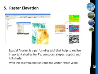
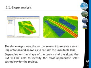
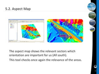
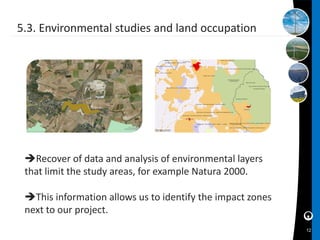
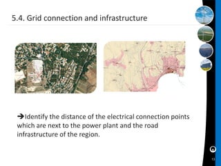
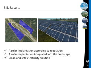
The Geographical Information System for the
Solar Projects Development


                                  Alejandro MAMIAN
                                 Jefe de proyectos SIG
                              Alejandro MAMIAN
                              GIS Project Manager
Summary
  1. Eolfi Profile
  2. Solar Energy
  3. Solar GIS
  4. Solar GIS Model
      4.1 Concepts
      4.2 Tools

  5. Raster Elevation
      5.1 Slope Analysis
      5.2 Aspect Map
      5.3 Environmental studies and land occupation
      5.4 Grid connection and infrastructure
      5.5 Results

  6. Conclusions

                                                      2
1. Eolfi Profile


Wind and solar subsidiary of Veolia Environnement

 Developer and operator in renewable energy
 Producer of wind and solar electricity
 Assets Managements


                                                    3
2. Solar Energy
    Photovoltaic power plants produce
     electricity according to sustainable
     development policy

    Evolution of PV technology

    Decentralized production without CO2
     emission

    Green Energy: clean and renewable

    Response to environmental commitment
     initiated by the Kyoto Protocol
                                            4
3. Solar GIS


   Solar GIS is a tool aiming at talking
    decision, capable of incorporating the
    information, experience, and
    know-how in the solar energy field.

   The integration of different skills
      reliable results.


                                             5
4. GIS Solar Model

                                 Understanding the needs of
                                development while respecting
                                the environment and each of
                                its aspects.

 Creation of spatial
connections between variables
• Grid Network - Capacity
• Distance to the grid


                                   Construction of the Solar
                                  GIS model with the help of a
                                  GIS software
                                                                 6
4.1. Concepts
      Goal
       To make an orography map from raster and vector
       data  Project Managers an able to build the layout
       of the PV power plant
      Means
       Arc GIS tools and Spatial Analyst extension
      Expected Result
       Implementation area, that takes into account:
       • Slope (Determines the feasibility and the pitch)
       • Shadows (Forbidden areas)
       • Obstacles (Trees, buildings, antennas …)
       • Orientation (Irradiation losses)
       • Environmental constraints (Natura 2000, RAMSAR…)
       • Grid connection (Costs)
                                                             7
4.2. Tools


             DTM / DSM very high
             resolution that allow us to
             define the slopes, shadows,
             aspects and visibility studies


                                                   Software for integration and
                                                   processing of graphics and
                                                   alphanumeric data

                 Cartographic Data

                                                   Tool for the measurement
                                                   of solar radiation


              BD ORTHO ® Ortho photograph color and 50 cm resolution
              25 SCAN ® Map at 1:25 000 standard


                                                                                  8
5. Raster Elevation


  Spatial Analyst is a performing tool that help to realize
  important studies for PV, contours, slopes, aspect and
  hill shade.
  With this tool you can transform the vector-raster-vector

                                                              9
5.1. Slope analysis


The slope map shows the sectors relevant to receive a solar
implantation and allows us to exclude the unsuitable land.
Depending on the shape of the terrain and the slope, the
PM will be able to identify the most appropriate solar
technology for the project.
                                                              10
5.2. Aspect Map


  The aspect map shows the relevant sectors which
  orientation are important for us (All south).
  This tool checks once again the relevance of the areas.


                                                            11
5.3. Environmental studies and land occupation


 Recover of data and analysis of environmental layers
 that limit the study areas, for example Natura 2000.

 This information allows us to identify the impact zones
 next to our project.
                                                            12
5.4. Grid connection and infrastructure


 Identify the distance of the electrical connection points
 which are next to the power plant and the road
 infrastructure of the region.


                                                              13
5.5. Results


 A solar implantation according to regulation
 A solar implantation integrated into the landscape
 Clean and safe electricity solution

                                                       14
6. Conclusions

   Immediate, practical and reliable response due to the
  performance of the GIS tool.

   Construction mapping that takes into account the territorial
  and environmental restrictions.

   Geo referenced database that facilitates the information
  transfer.

   Take decisions more efficiently thanks to a more efficient
  mapping.

   Reduced time and costs of environmental studies, scoping
  and territorial analysis.
                                                                   15
Thank you


                                            Solar Parking PSA Peugeot
                                                     1.4 MW


                                  Contact
                                  Alejandro MAMIAN
                                  GIS Project Manager
    Wind Farm of Monts Bergeron
              22 MW               Engineering & Innovation Department
                                  alejandro.mamian@eolfi.com

                                                                        16

The GIS for the Solar Projects Development

  • 1.
    The Geographical InformationSystem for the Solar Projects Development Alejandro MAMIAN Jefe de proyectos SIG Alejandro MAMIAN GIS Project Manager
  • 2.
    Summary 1.Eolfi Profile 2. Solar Energy 3. Solar GIS 4. Solar GIS Model 4.1 Concepts 4.2 Tools 5. Raster Elevation 5.1 Slope Analysis 5.2 Aspect Map 5.3 Environmental studies and land occupation 5.4 Grid connection and infrastructure 5.5 Results 6. Conclusions 2
  • 3.
    1. Eolfi Profile Windand solar subsidiary of Veolia Environnement  Developer and operator in renewable energy  Producer of wind and solar electricity  Assets Managements 3
  • 4.
    2. Solar Energy  Photovoltaic power plants produce electricity according to sustainable development policy  Evolution of PV technology  Decentralized production without CO2 emission  Green Energy: clean and renewable  Response to environmental commitment initiated by the Kyoto Protocol 4
  • 5.
    3. Solar GIS  Solar GIS is a tool aiming at talking decision, capable of incorporating the information, experience, and know-how in the solar energy field.  The integration of different skills  reliable results. 5
  • 6.
    4. GIS SolarModel  Understanding the needs of development while respecting the environment and each of its aspects.  Creation of spatial connections between variables • Grid Network - Capacity • Distance to the grid  Construction of the Solar GIS model with the help of a GIS software 6
  • 7.
    4.1. Concepts  Goal To make an orography map from raster and vector data  Project Managers an able to build the layout of the PV power plant  Means Arc GIS tools and Spatial Analyst extension  Expected Result Implementation area, that takes into account: • Slope (Determines the feasibility and the pitch) • Shadows (Forbidden areas) • Obstacles (Trees, buildings, antennas …) • Orientation (Irradiation losses) • Environmental constraints (Natura 2000, RAMSAR…) • Grid connection (Costs) 7
  • 8.
    4.2. Tools DTM / DSM very high resolution that allow us to define the slopes, shadows, aspects and visibility studies Software for integration and processing of graphics and alphanumeric data Cartographic Data Tool for the measurement of solar radiation BD ORTHO ® Ortho photograph color and 50 cm resolution 25 SCAN ® Map at 1:25 000 standard 8
  • 9.
    5. Raster Elevation Spatial Analyst is a performing tool that help to realize important studies for PV, contours, slopes, aspect and hill shade. With this tool you can transform the vector-raster-vector 9
  • 10.
    5.1. Slope analysis Theslope map shows the sectors relevant to receive a solar implantation and allows us to exclude the unsuitable land. Depending on the shape of the terrain and the slope, the PM will be able to identify the most appropriate solar technology for the project. 10
  • 11.
    5.2. Aspect Map The aspect map shows the relevant sectors which orientation are important for us (All south). This tool checks once again the relevance of the areas. 11
  • 12.
    5.3. Environmental studiesand land occupation Recover of data and analysis of environmental layers that limit the study areas, for example Natura 2000. This information allows us to identify the impact zones next to our project. 12
  • 13.
    5.4. Grid connectionand infrastructure Identify the distance of the electrical connection points which are next to the power plant and the road infrastructure of the region. 13
  • 14.
    5.5. Results  Asolar implantation according to regulation  A solar implantation integrated into the landscape  Clean and safe electricity solution 14
  • 15.
    6. Conclusions  Immediate, practical and reliable response due to the performance of the GIS tool.  Construction mapping that takes into account the territorial and environmental restrictions.  Geo referenced database that facilitates the information transfer.  Take decisions more efficiently thanks to a more efficient mapping.  Reduced time and costs of environmental studies, scoping and territorial analysis. 15
  • 16.
    Thank you Solar Parking PSA Peugeot 1.4 MW Contact Alejandro MAMIAN GIS Project Manager Wind Farm of Monts Bergeron 22 MW Engineering & Innovation Department alejandro.mamian@eolfi.com 16