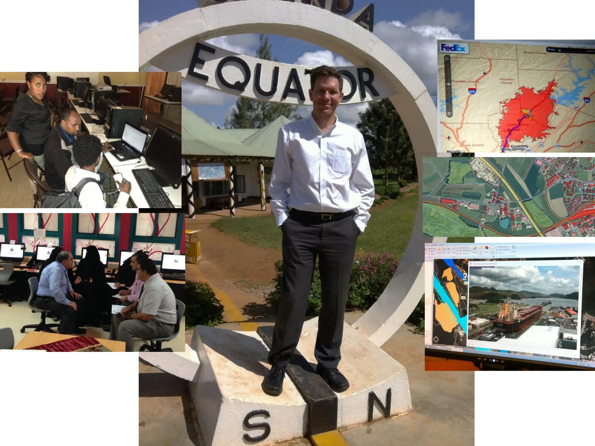
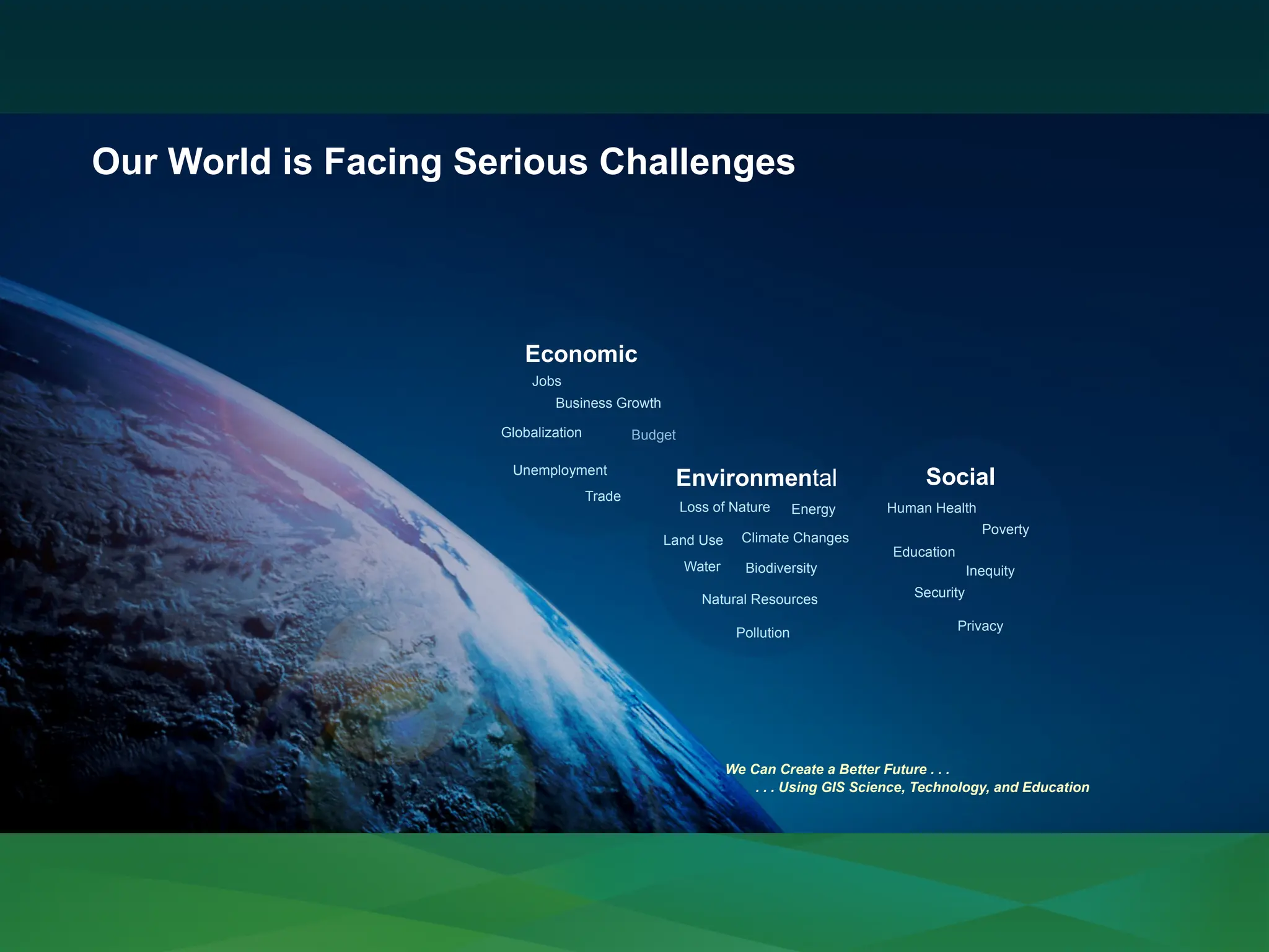
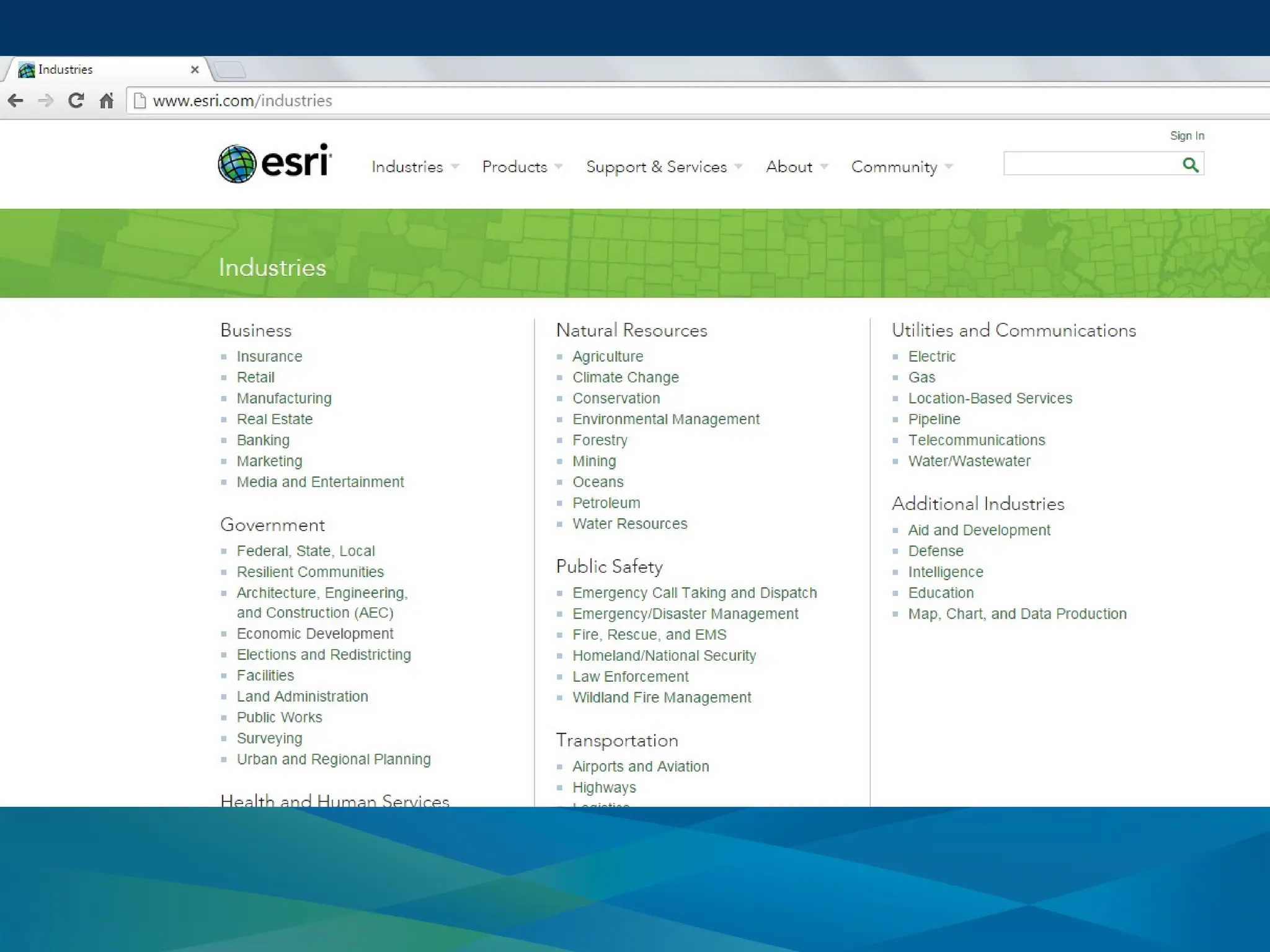
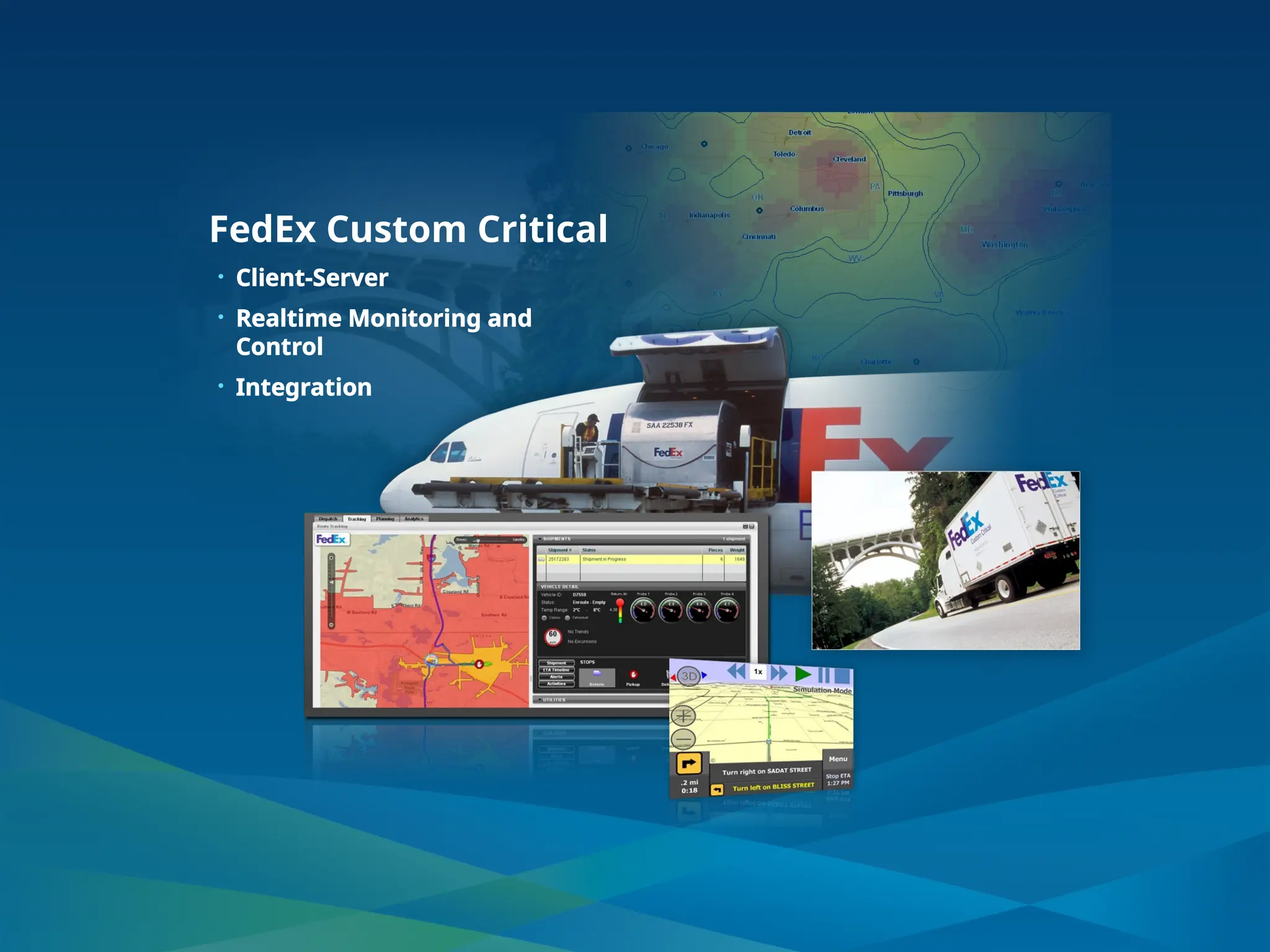
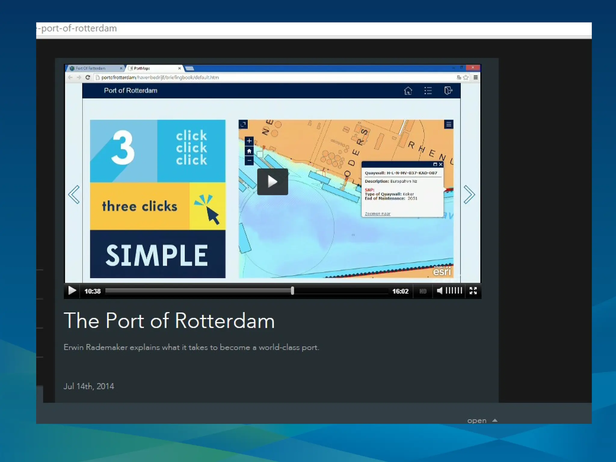
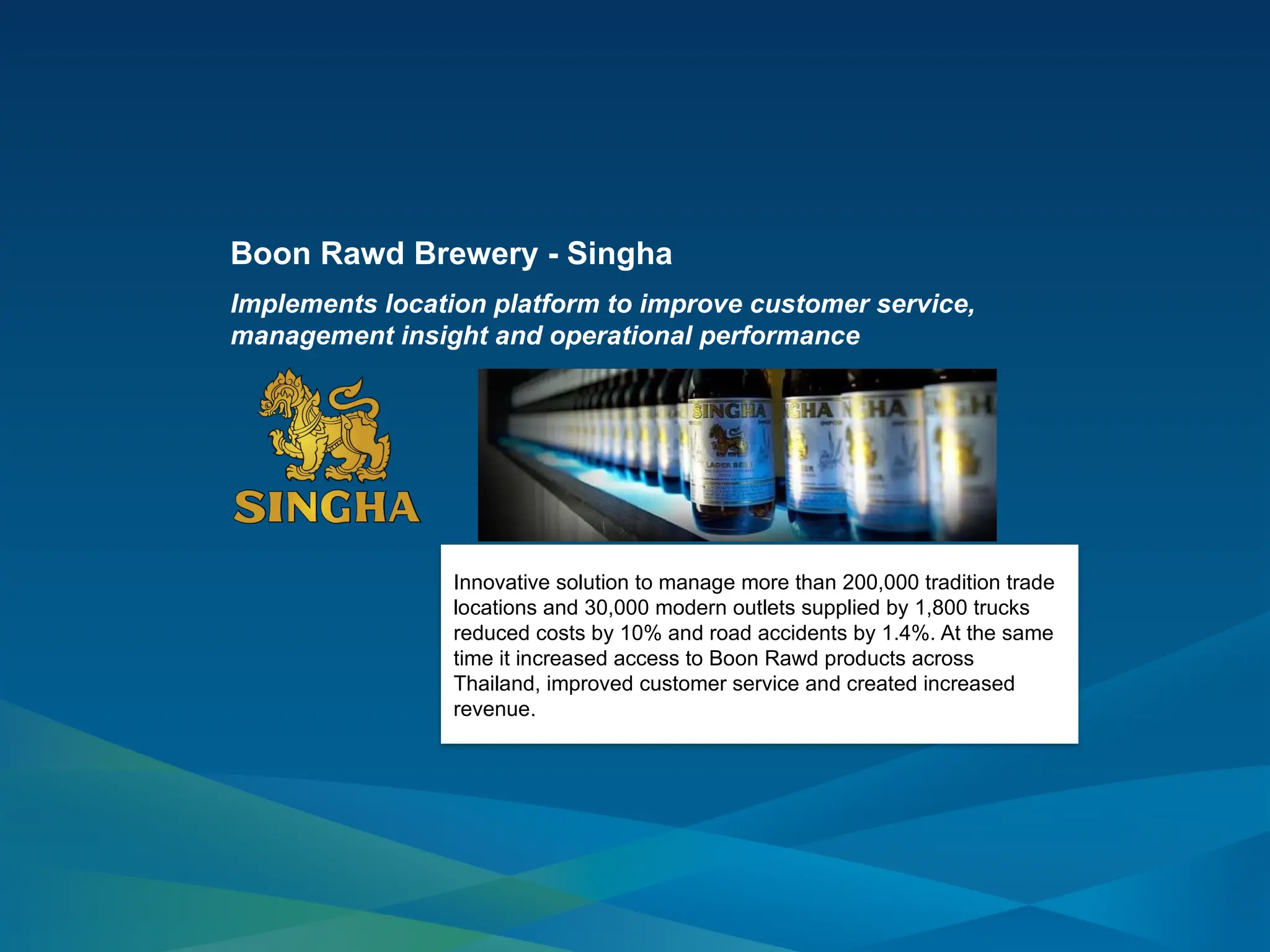
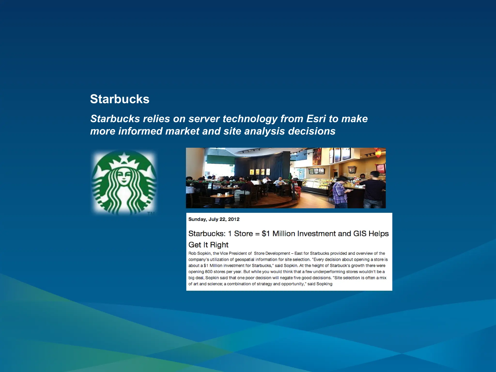
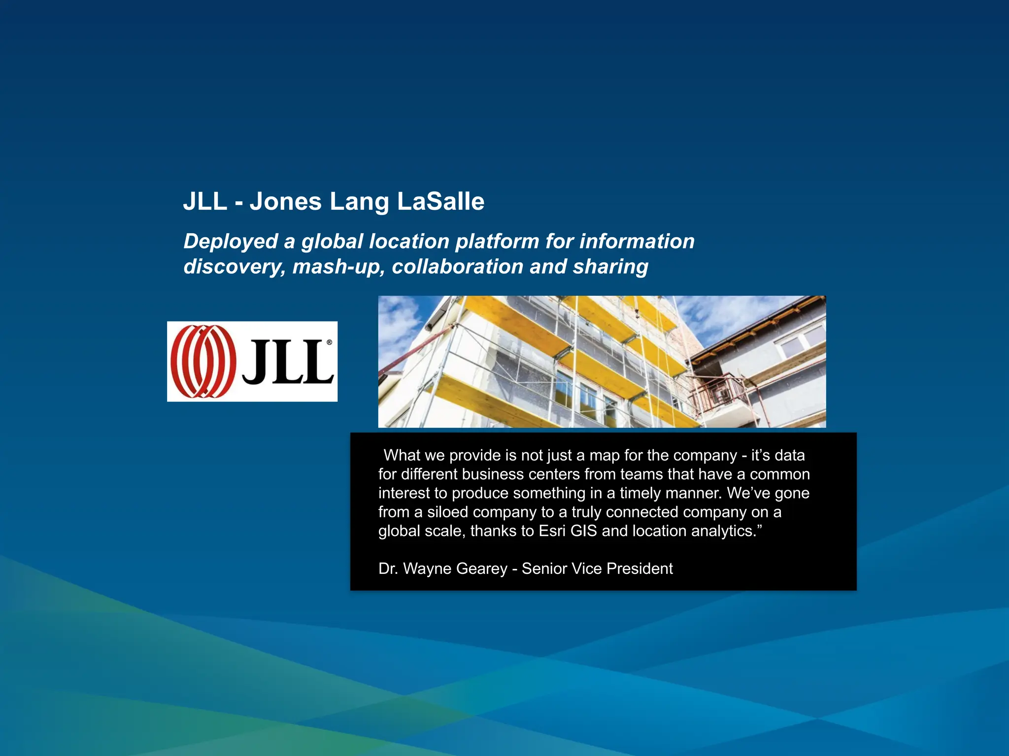
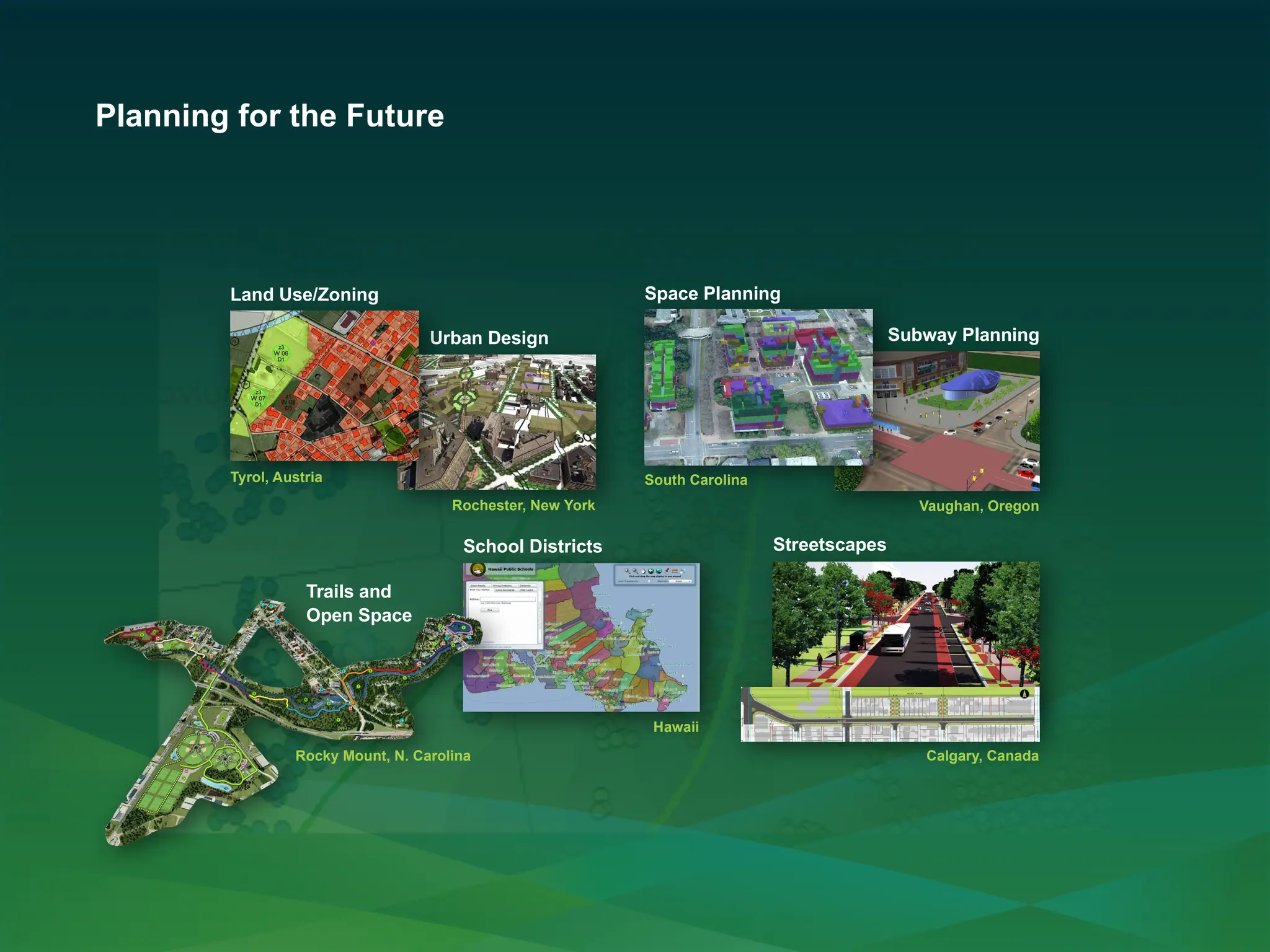
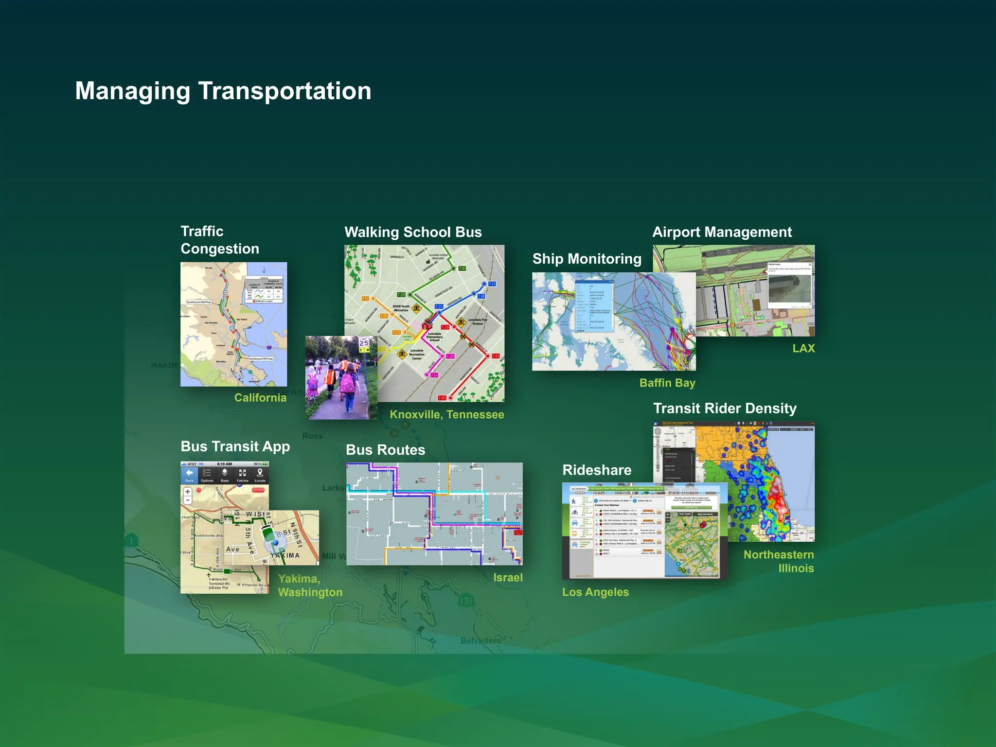
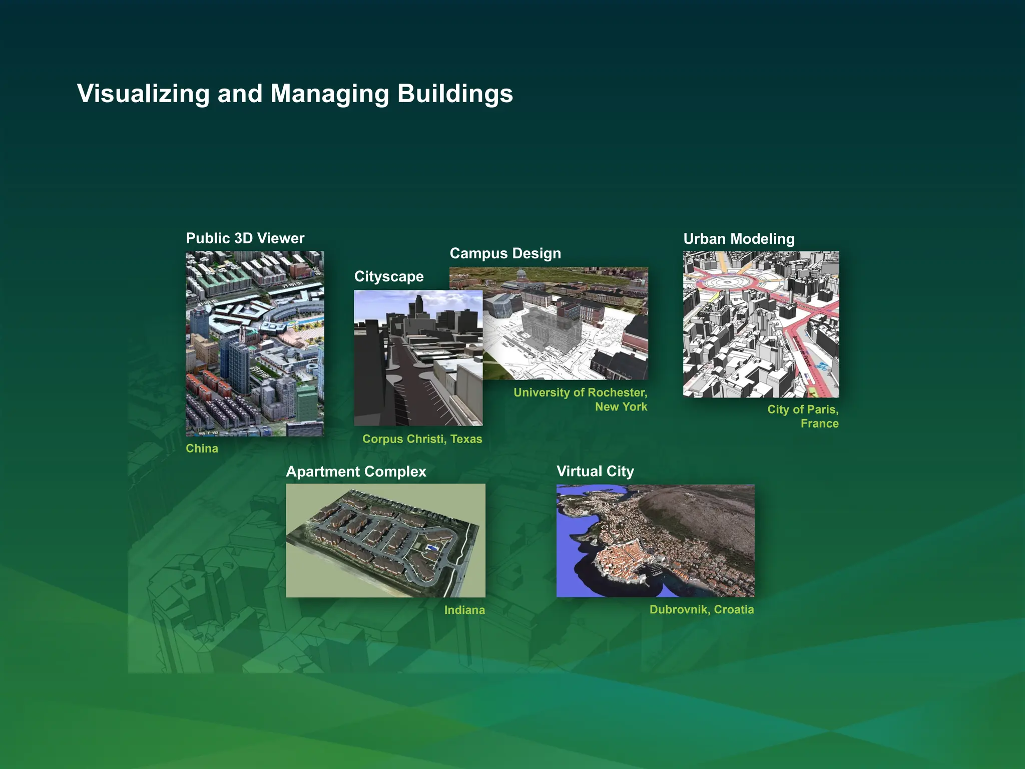
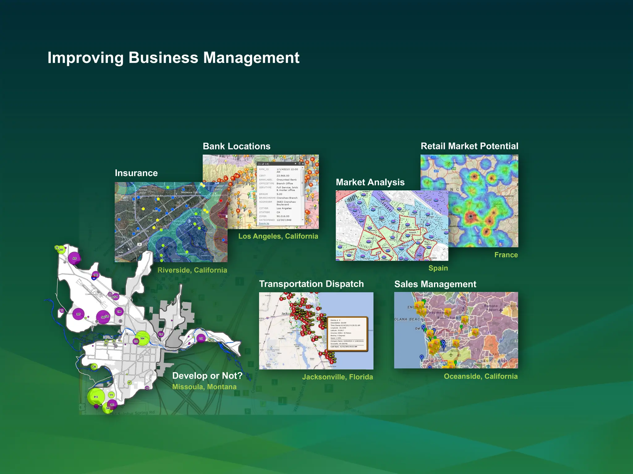
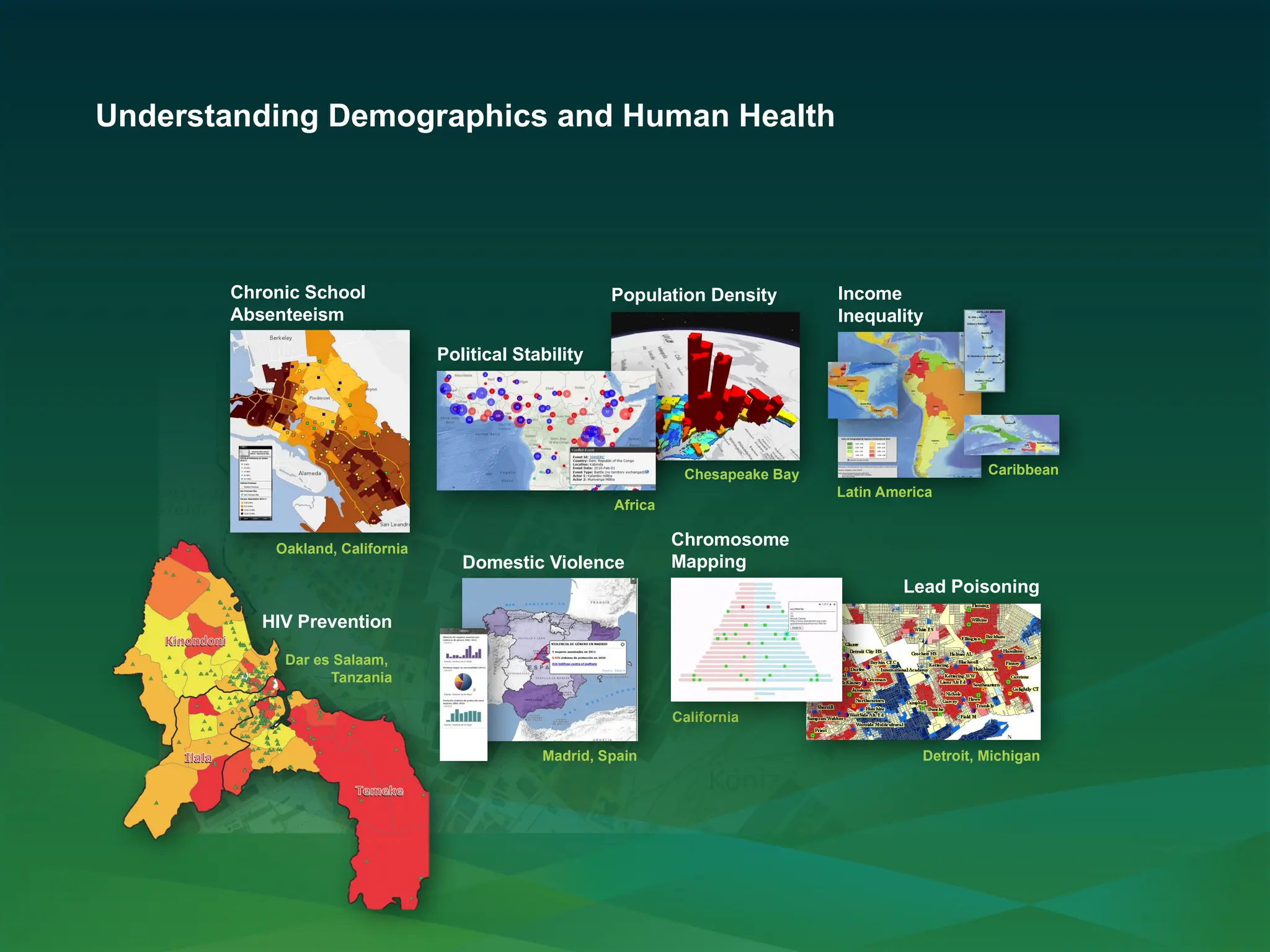
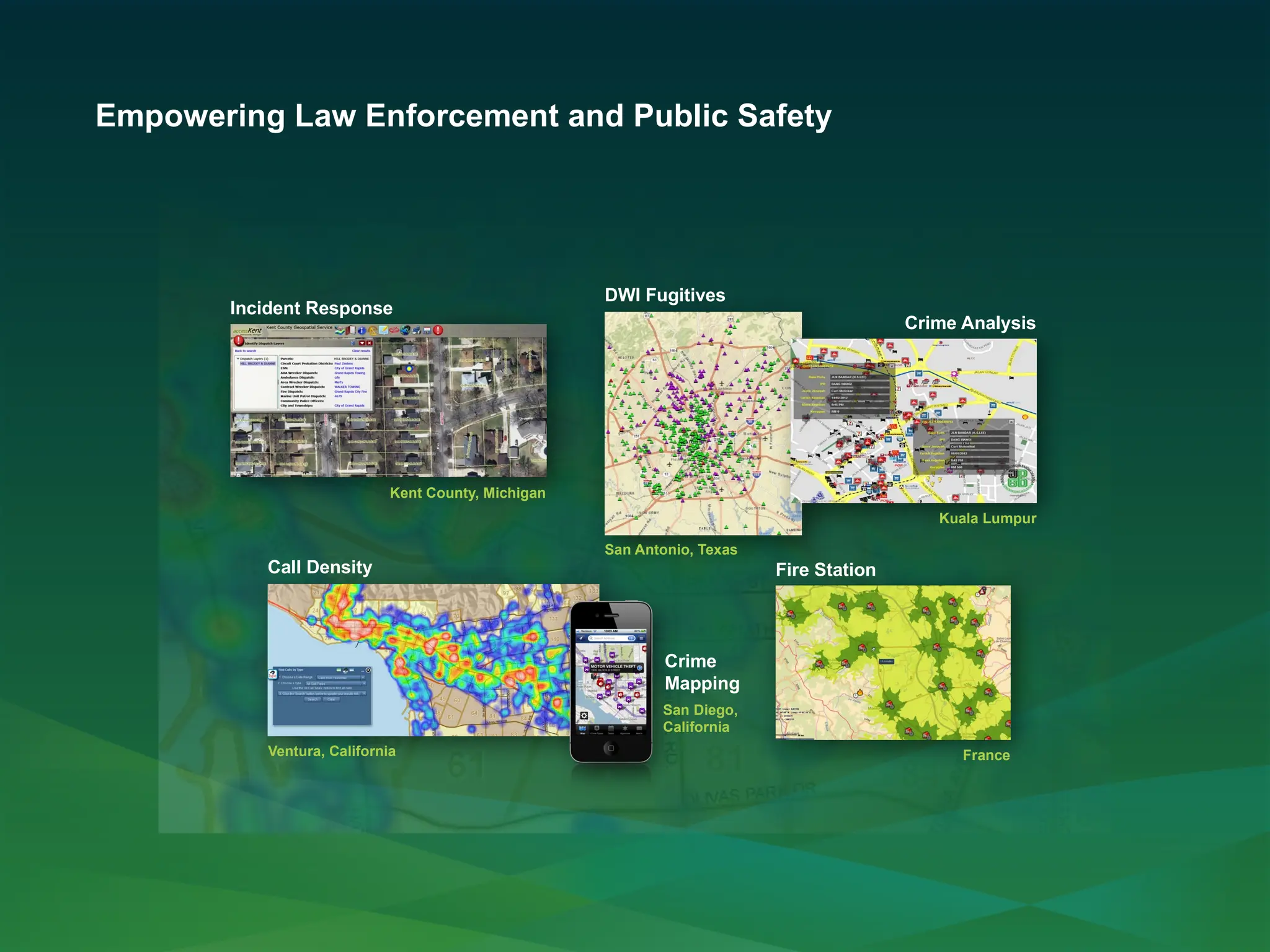
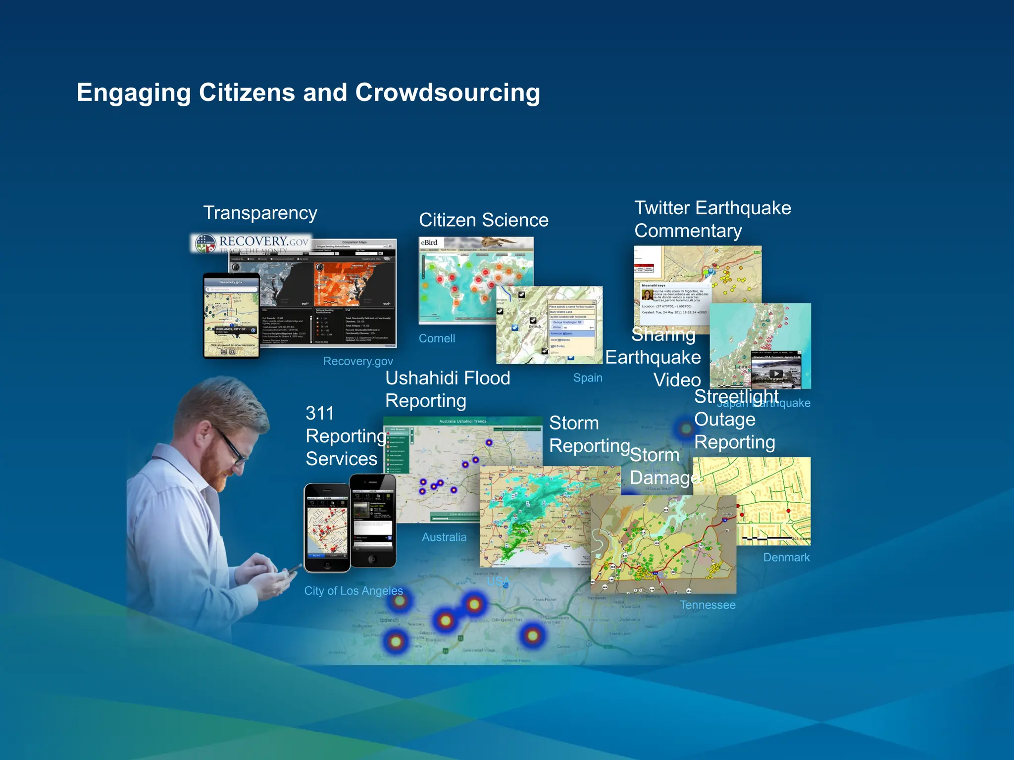
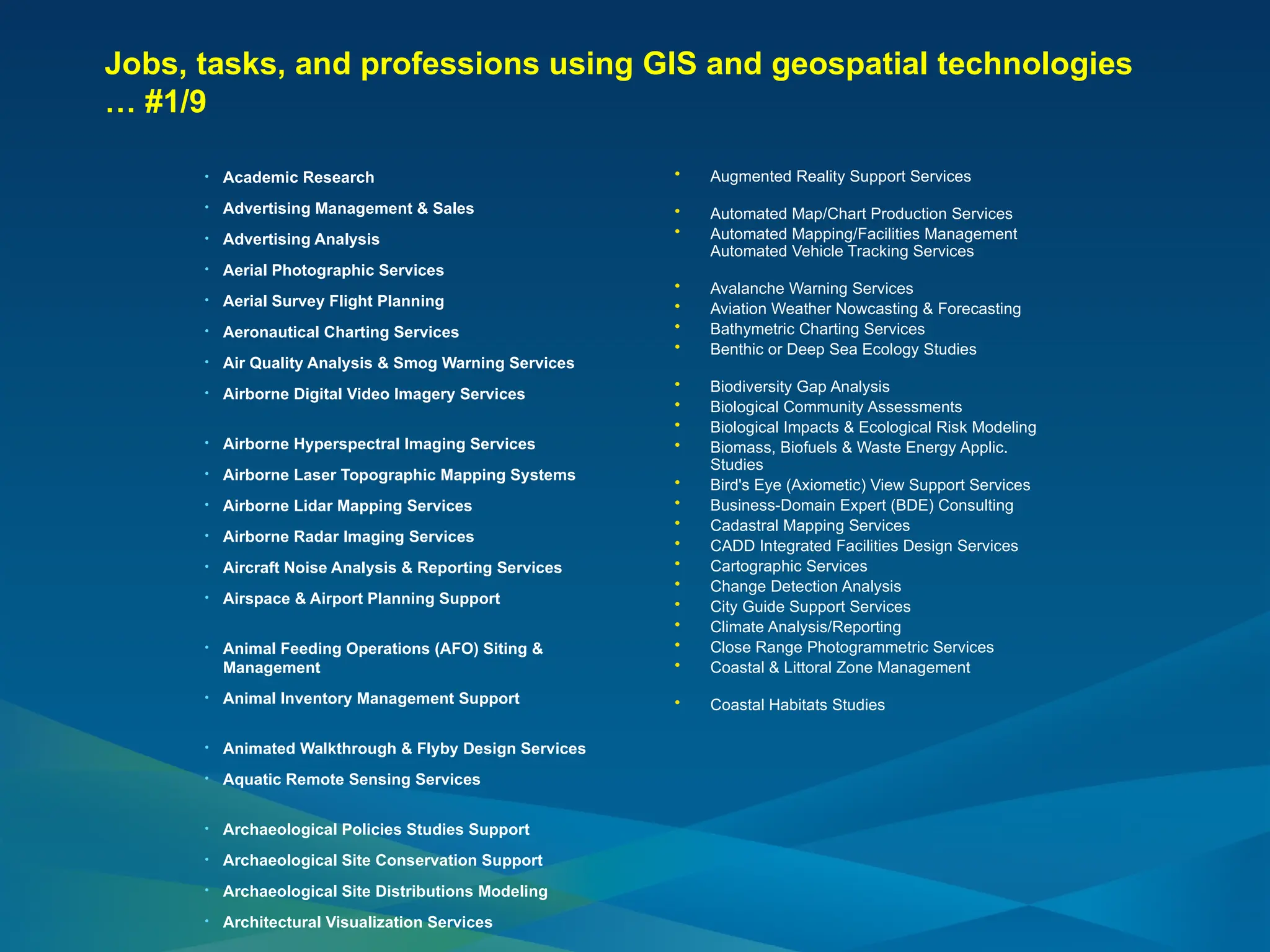
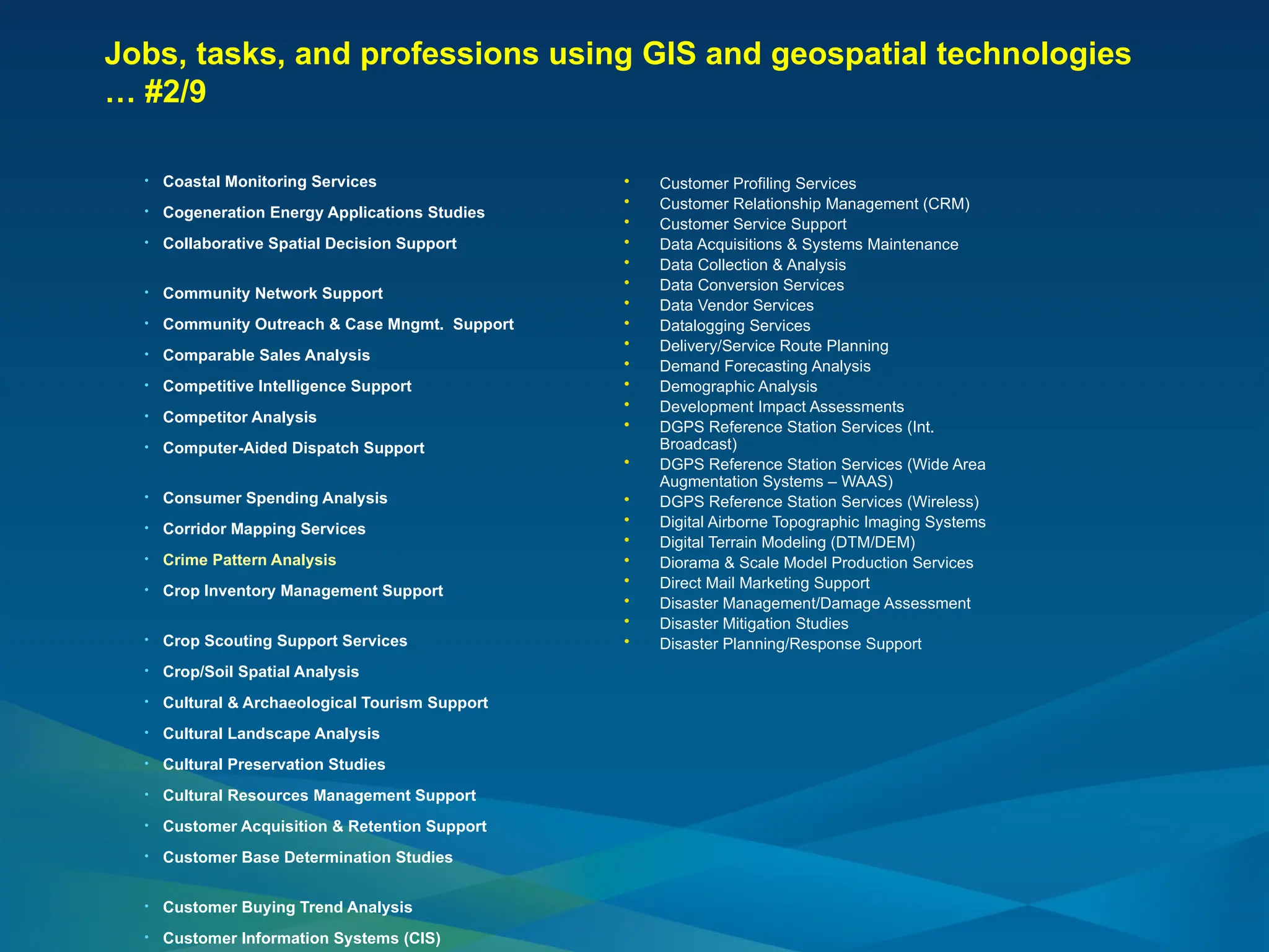
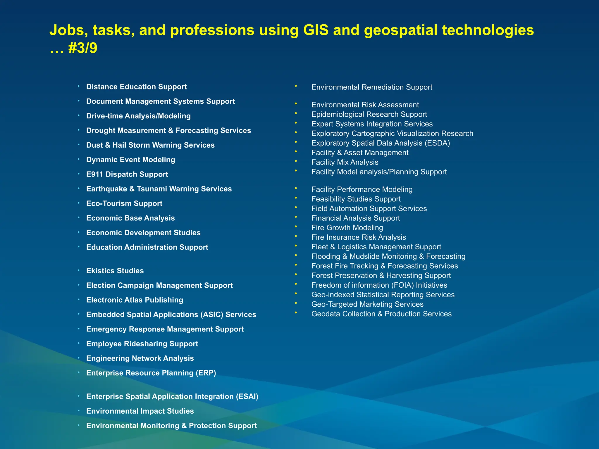
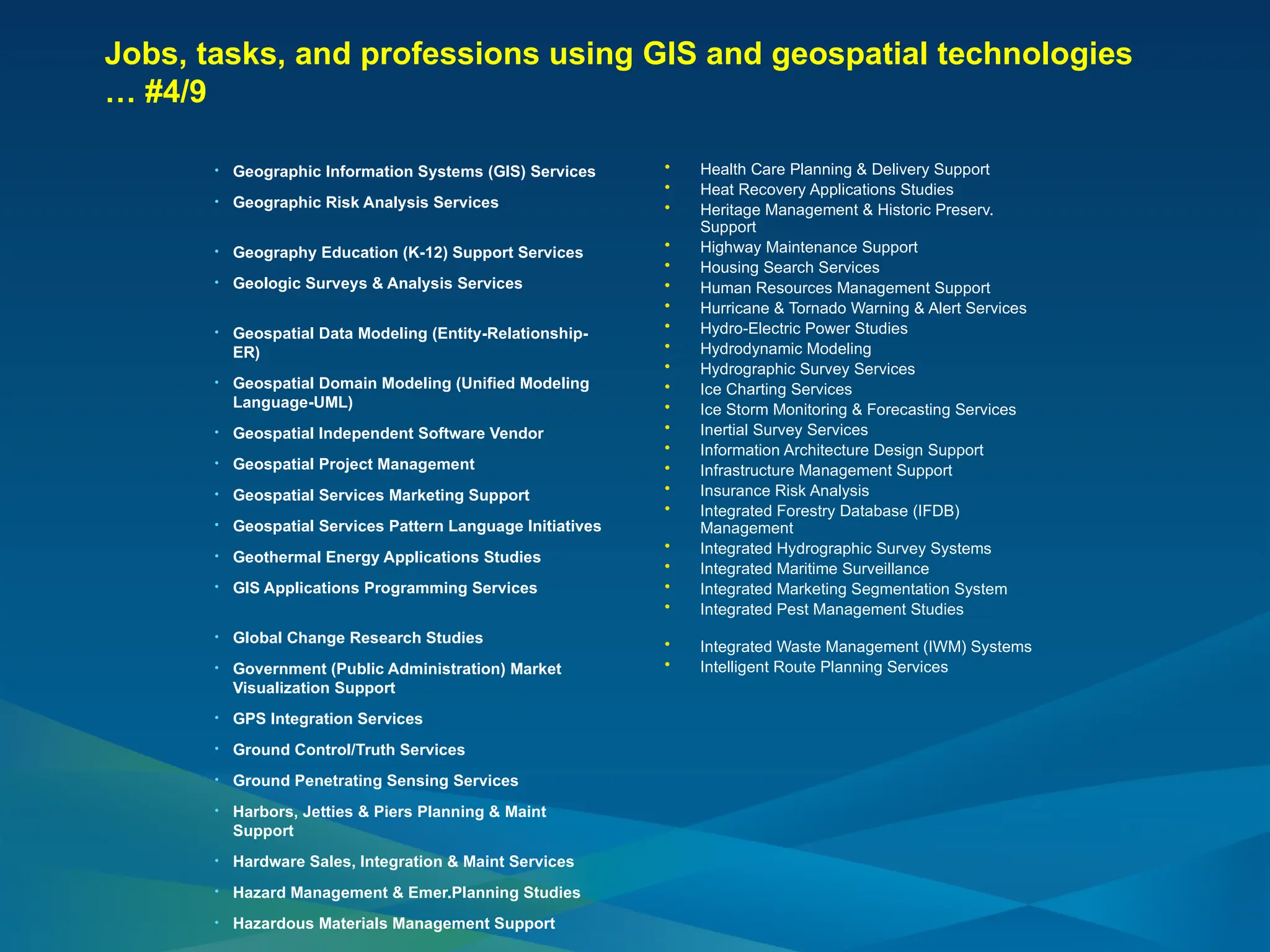
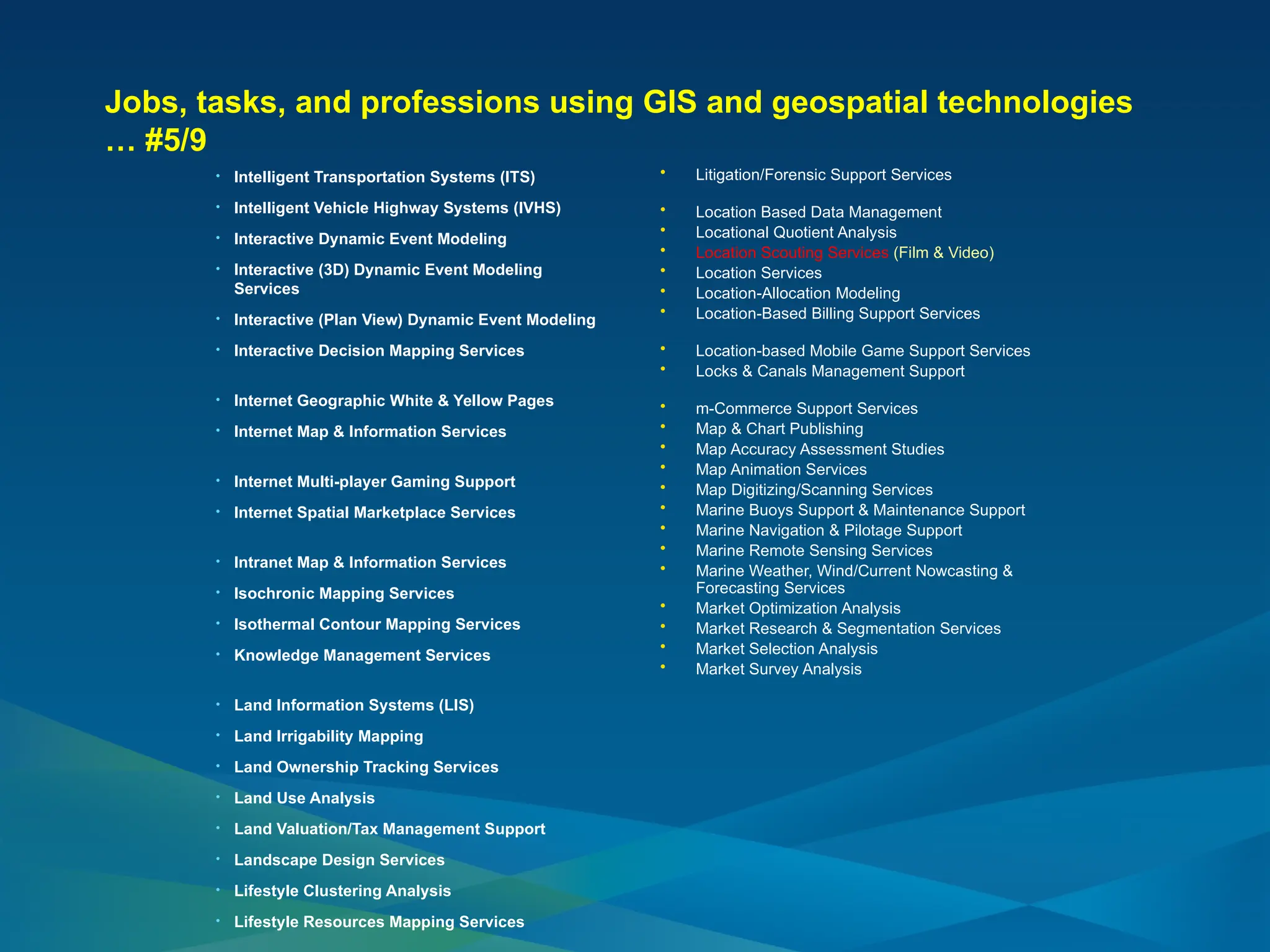
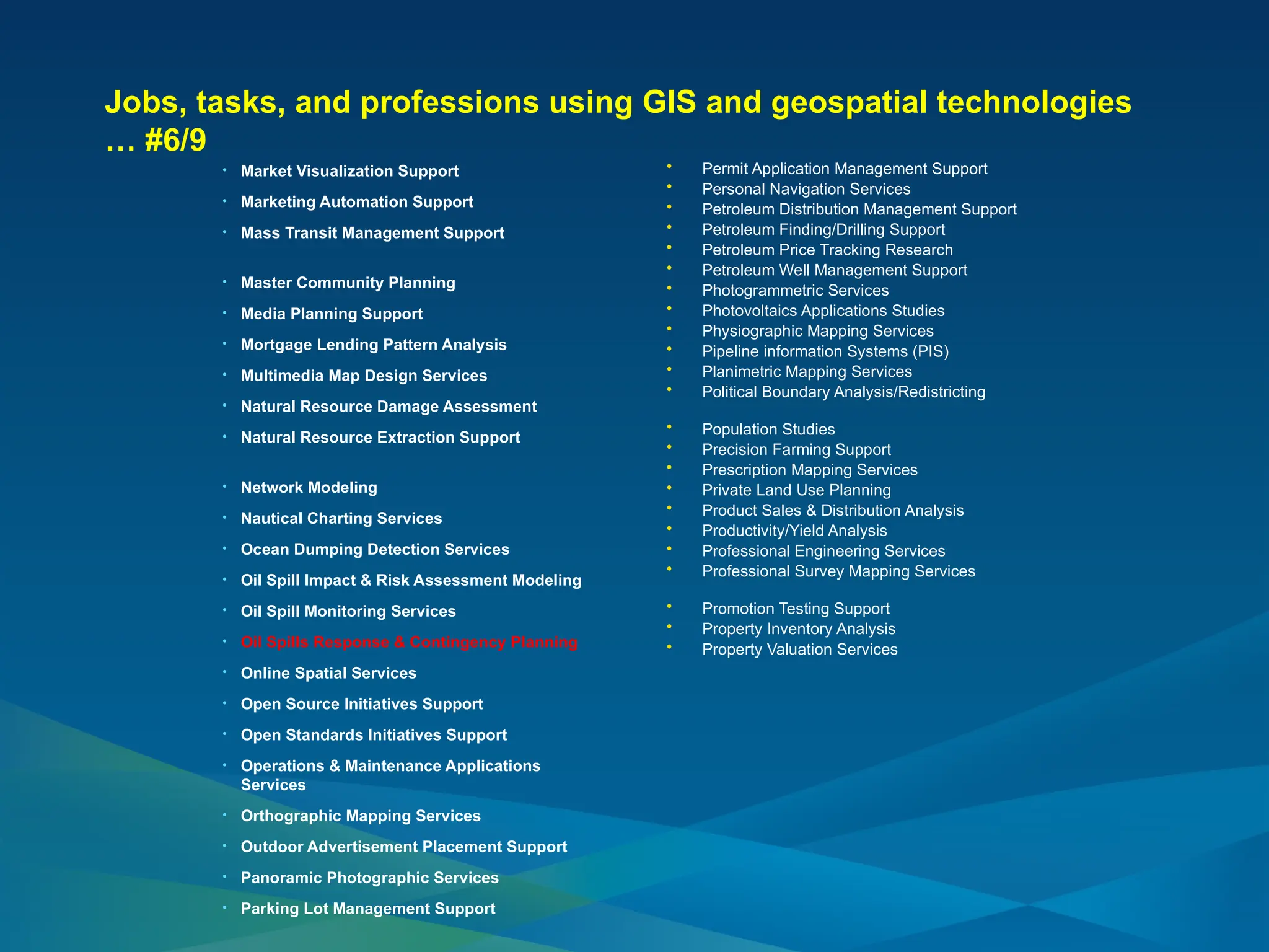
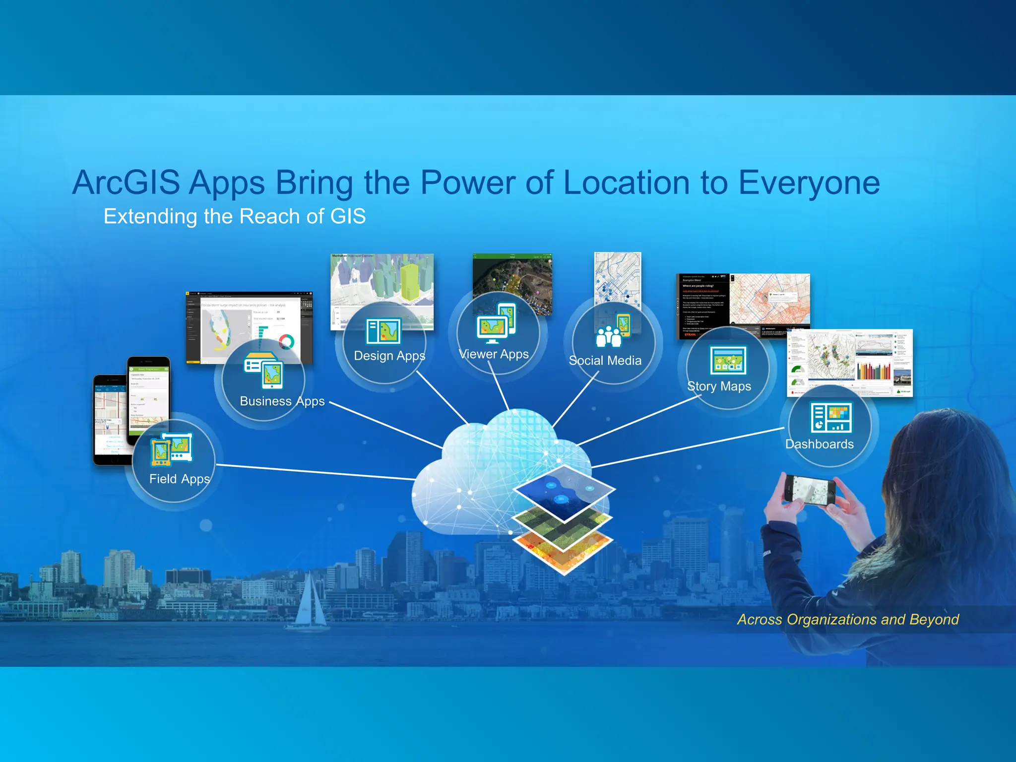
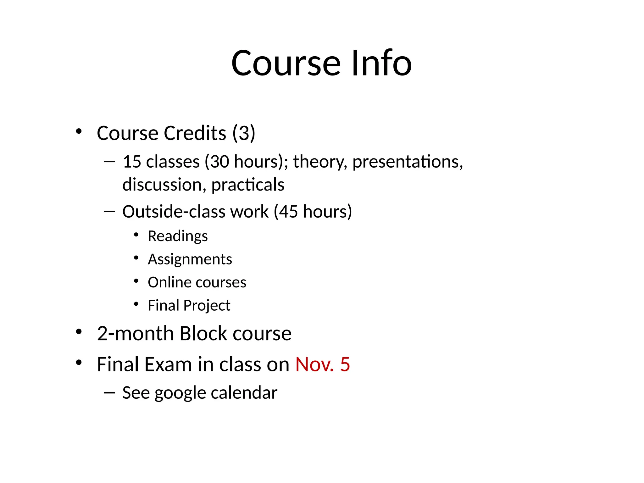
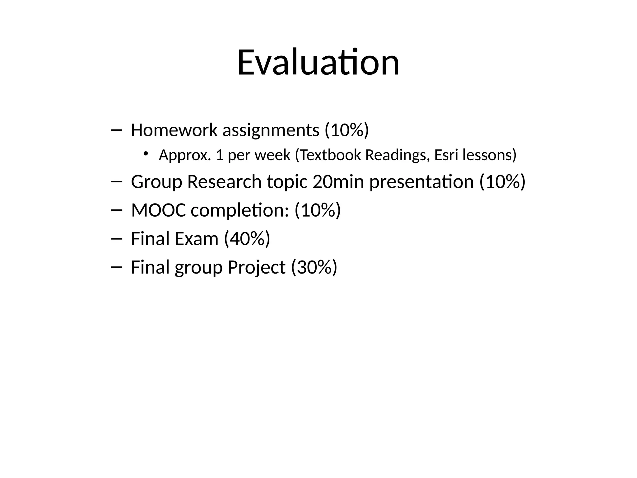
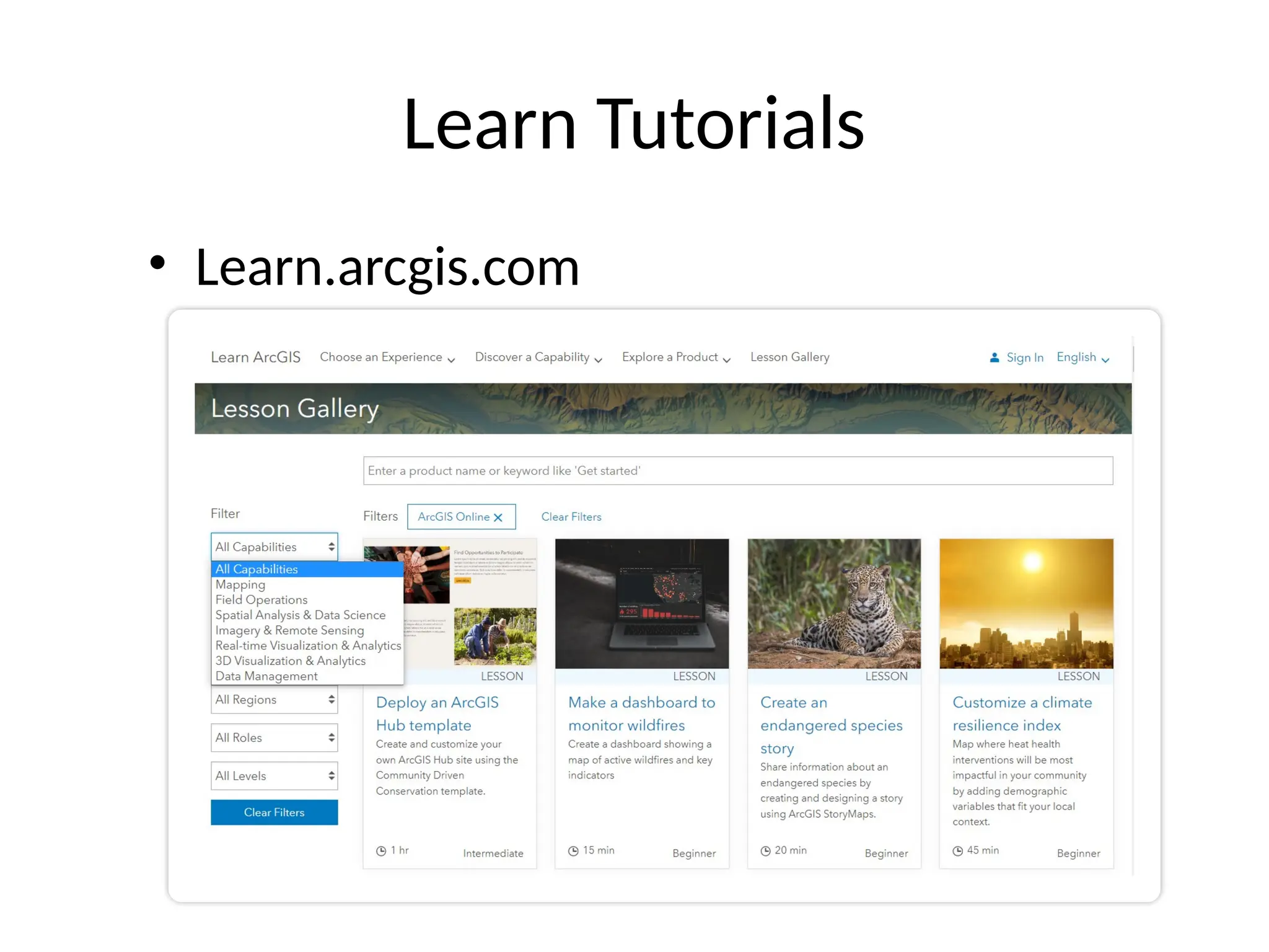
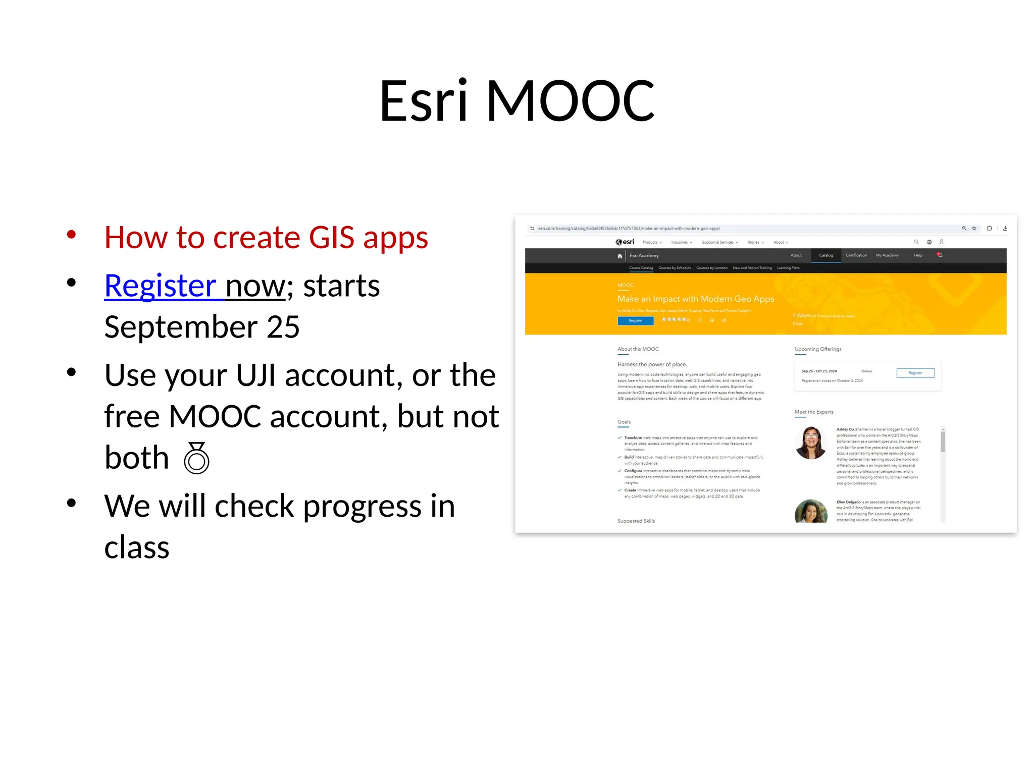
Presentation of
GIS: Desktop to Web
(SJL004)
Master in Geospatial Technologies
Universitat Jaume I – 2024
Instructors
• Dr. Michael Gould
– gould@uji.es
– Office: NB3312DI
– Building: “Investigación 2”
• Fabio (Nicolás) Luna
– fluna@uji.es
– 3rd floor Investigación 2
Introductions (Sept 17)
• Tell us your preferred name
• Tell us your Academic and Work background
• Tell us your “GIS story”
– “just getting started”, “working 2 years in a GIS
department”, “this is my first exposure to GIS”,…
Our World is Facing Serious Challenges
Budget
Economic
Globalization
Business Growth
Jobs
Trade
Unemployment
Social
Poverty
Human Health
Education
Inequity
Security
Privacy
Environmental
Natural Resources
Energy
Biodiversity
Land Use Climate Changes
Pollution
Water
Loss of Nature
We Can Create a Better Future . . .
. . . Using GIS Science, Technology, and Education
FedEx Custom Critical
• Client-Server
• Realtime Monitoring and
Control
• Integration
Innovative solution to manage more than 200,000 tradition trade
locations and 30,000 modern outlets supplied by 1,800 trucks
reduced costs by 10% and road accidents by 1.4%. At the same
time it increased access to Boon Rawd products across
Thailand, improved customer service and created increased
revenue.
Boon Rawd Brewery - Singha
Implements location platform to improve customer service,
management insight and operational performance
Starbucks
Starbucks relies on server technology from Esri to make
more informed market and site analysis decisions
Amp Energy - A Pepsi Company
Implements location-aware marketing campaigns with
a major convenience store
Innovative marketing program
drove sales distribution and end-
cap displays went up 70 percent at
participating stores during the
promotion.
JLL - Jones Lang LaSalle
Deployed a global location platform for information
discovery, mash-up, collaboration and sharing
“What we provide is not just a map for the company - it’s data
for different business centers from teams that have a common
interest to produce something in a timely manner. We’ve gone
from a siloed company to a truly connected company on a
global scale, thanks to Esri GIS and location analytics.”
Dr. Wayne Gearey - Senior Vice President
Planning for the Future
Streetscapes
Calgary, Canada
Vaughan, Oregon
Subway Planning
Space Planning
South Carolina
Hawaii
School Districts
Rochester, New York
Urban Design
Rocky Mount, N. Carolina
Trails and
Open Space
Land Use/Zoning
Tyrol, Austria
Managing Transportation
Airport Management
LAX
Ship Monitoring
Baffin Bay
Traffic
Congestion
California
Bus Routes
Israel
Knoxville, Tennessee
Walking School Bus
Bus Transit App
Yakima,
Washington
Transit Rider Density
Northeastern
Illinois
Rideshare
Los Angeles
Visualizing and Managing Buildings
Public 3D Viewer
China
Urban Modeling
City of Paris,
France
Campus Design
University of Rochester,
New York
Virtual City
Dubrovnik, Croatia
Apartment Complex
Indiana
Cityscape
Corpus Christi, Texas
Improving Business Management
Bank Locations
Los Angeles, California
Retail Market Potential
France
Market Analysis
Spain
Insurance
Riverside, California
Transportation Dispatch
Jacksonville, Florida
Sales Management
Oceanside, California
Missoula, Montana
Develop or Not?
Understanding Demographics and Human Health
Lead Poisoning
Detroit, Michigan
Population Density
Chesapeake Bay
Domestic Violence
Madrid, Spain
Chromosome
Mapping
California
Political Stability
Africa
HIV Prevention
Dar es Salaam,
Tanzania
Chronic School
Absenteeism
Oakland, California
Income
Inequality
Latin America
Caribbean
Empowering Law Enforcement and Public Safety
Incident Response
Kent County, Michigan
Call Density
Ventura, California
Fire Station
France
San Diego,
California
Crime
Mapping
DWI Fugitives
San Antonio, Texas
Crime Analysis
Kuala Lumpur
Engaging Citizens and Crowdsourcing
Recovery.gov
Transparency Twitter Earthquake
Commentary
Sharing
Earthquake
Video
Japan Earthquake
Streetlight
Outage
Reporting
Denmark
Ushahidi Flood
Reporting
Australia
City of Los Angeles
311
Reporting
Services
Storm
Reporting
USA
Storm
Damage
Tennessee
Citizen Science
Cornell
Spain
Jobs, tasks, and professions using GIS and geospatial technologies
… #1/9
• Academic Research
• Advertising Management & Sales
• Advertising Analysis
• Aerial Photographic Services
• Aerial Survey Flight Planning
• Aeronautical Charting Services
• Air Quality Analysis & Smog Warning Services
• Airborne Digital Video Imagery Services
• Airborne Hyperspectral Imaging Services
• Airborne Laser Topographic Mapping Systems
• Airborne Lidar Mapping Services
• Airborne Radar Imaging Services
• Aircraft Noise Analysis & Reporting Services
• Airspace & Airport Planning Support
• Animal Feeding Operations (AFO) Siting &
Management
• Animal Inventory Management Support
• Animated Walkthrough & Flyby Design Services
• Aquatic Remote Sensing Services
• Archaeological Policies Studies Support
• Archaeological Site Conservation Support
• Archaeological Site Distributions Modeling
• Architectural Visualization Services
• Augmented Reality Support Services
• Automated Map/Chart Production Services
• Automated Mapping/Facilities Management
Automated Vehicle Tracking Services
• Avalanche Warning Services
• Aviation Weather Nowcasting & Forecasting
• Bathymetric Charting Services
• Benthic or Deep Sea Ecology Studies
• Biodiversity Gap Analysis
• Biological Community Assessments
• Biological Impacts & Ecological Risk Modeling
• Biomass, Biofuels & Waste Energy Applic.
Studies
• Bird's Eye (Axiometic) View Support Services
• Business-Domain Expert (BDE) Consulting
• Cadastral Mapping Services
• CADD Integrated Facilities Design Services
• Cartographic Services
• Change Detection Analysis
• City Guide Support Services
• Climate Analysis/Reporting
• Close Range Photogrammetric Services
• Coastal & Littoral Zone Management
• Coastal Habitats Studies
Jobs, tasks, and professions using GIS and geospatial technologies
… #2/9
• Coastal Monitoring Services
• Cogeneration Energy Applications Studies
• Collaborative Spatial Decision Support
• Community Network Support
• Community Outreach & Case Mngmt. Support
• Comparable Sales Analysis
• Competitive Intelligence Support
• Competitor Analysis
• Computer-Aided Dispatch Support
• Consumer Spending Analysis
• Corridor Mapping Services
• Crime Pattern Analysis
• Crop Inventory Management Support
• Crop Scouting Support Services
• Crop/Soil Spatial Analysis
• Cultural & Archaeological Tourism Support
• Cultural Landscape Analysis
• Cultural Preservation Studies
• Cultural Resources Management Support
• Customer Acquisition & Retention Support
• Customer Base Determination Studies
• Customer Buying Trend Analysis
• Customer Information Systems (CIS)
• Customer Profiling Services
• Customer Relationship Management (CRM)
• Customer Service Support
• Data Acquisitions & Systems Maintenance
• Data Collection & Analysis
• Data Conversion Services
• Data Vendor Services
• Datalogging Services
• Delivery/Service Route Planning
• Demand Forecasting Analysis
• Demographic Analysis
• Development Impact Assessments
• DGPS Reference Station Services (Int.
Broadcast)
• DGPS Reference Station Services (Wide Area
Augmentation Systems – WAAS)
• DGPS Reference Station Services (Wireless)
• Digital Airborne Topographic Imaging Systems
• Digital Terrain Modeling (DTM/DEM)
• Diorama & Scale Model Production Services
• Direct Mail Marketing Support
• Disaster Management/Damage Assessment
• Disaster Mitigation Studies
• Disaster Planning/Response Support
Jobs, tasks, and professions using GIS and geospatial technologies
… #3/9
• Distance Education Support
• Document Management Systems Support
• Drive-time Analysis/Modeling
• Drought Measurement & Forecasting Services
• Dust & Hail Storm Warning Services
• Dynamic Event Modeling
• E911 Dispatch Support
• Earthquake & Tsunami Warning Services
• Eco-Tourism Support
• Economic Base Analysis
• Economic Development Studies
• Education Administration Support
• Ekistics Studies
• Election Campaign Management Support
• Electronic Atlas Publishing
• Embedded Spatial Applications (ASIC) Services
• Emergency Response Management Support
• Employee Ridesharing Support
• Engineering Network Analysis
• Enterprise Resource Planning (ERP)
• Enterprise Spatial Application Integration (ESAI)
• Environmental Impact Studies
• Environmental Monitoring & Protection Support
• Environmental Remediation Support
• Environmental Risk Assessment
• Epidemiological Research Support
• Expert Systems Integration Services
• Exploratory Cartographic Visualization Research
• Exploratory Spatial Data Analysis (ESDA)
• Facility & Asset Management
• Facility Mix Analysis
• Facility Model analysis/Planning Support
• Facility Performance Modeling
• Feasibility Studies Support
• Field Automation Support Services
• Financial Analysis Support
• Fire Growth Modeling
• Fire Insurance Risk Analysis
• Fleet & Logistics Management Support
• Flooding & Mudslide Monitoring & Forecasting
• Forest Fire Tracking & Forecasting Services
• Forest Preservation & Harvesting Support
• Freedom of information (FOIA) Initiatives
• Geo-indexed Statistical Reporting Services
• Geo-Targeted Marketing Services
• Geodata Collection & Production Services
Jobs, tasks, and professions using GIS and geospatial technologies
… #4/9
• Geographic Information Systems (GIS) Services
• Geographic Risk Analysis Services
• Geography Education (K-12) Support Services
• Geologic Surveys & Analysis Services
• Geospatial Data Modeling (Entity-Relationship-
ER)
• Geospatial Domain Modeling (Unified Modeling
Language-UML)
• Geospatial Independent Software Vendor
• Geospatial Project Management
• Geospatial Services Marketing Support
• Geospatial Services Pattern Language Initiatives
• Geothermal Energy Applications Studies
• GIS Applications Programming Services
• Global Change Research Studies
• Government (Public Administration) Market
Visualization Support
• GPS Integration Services
• Ground Control/Truth Services
• Ground Penetrating Sensing Services
• Harbors, Jetties & Piers Planning & Maint
Support
• Hardware Sales, Integration & Maint Services
• Hazard Management & Emer.Planning Studies
• Hazardous Materials Management Support
• Health Care Planning & Delivery Support
• Heat Recovery Applications Studies
• Heritage Management & Historic Preserv.
Support
• Highway Maintenance Support
• Housing Search Services
• Human Resources Management Support
• Hurricane & Tornado Warning & Alert Services
• Hydro-Electric Power Studies
• Hydrodynamic Modeling
• Hydrographic Survey Services
• Ice Charting Services
• Ice Storm Monitoring & Forecasting Services
• Inertial Survey Services
• Information Architecture Design Support
• Infrastructure Management Support
• Insurance Risk Analysis
• Integrated Forestry Database (IFDB)
Management
• Integrated Hydrographic Survey Systems
• Integrated Maritime Surveillance
• Integrated Marketing Segmentation System
• Integrated Pest Management Studies
• Integrated Waste Management (IWM) Systems
• Intelligent Route Planning Services
Jobs, tasks, and professions using GIS and geospatial technologies
… #5/9
• Intelligent Transportation Systems (ITS)
• Intelligent Vehicle Highway Systems (IVHS)
• Interactive Dynamic Event Modeling
• Interactive (3D) Dynamic Event Modeling
Services
• Interactive (Plan View) Dynamic Event Modeling
• Interactive Decision Mapping Services
• Internet Geographic White & Yellow Pages
• Internet Map & Information Services
• Internet Multi-player Gaming Support
• Internet Spatial Marketplace Services
• Intranet Map & Information Services
• Isochronic Mapping Services
• Isothermal Contour Mapping Services
• Knowledge Management Services
• Land Information Systems (LIS)
• Land Irrigability Mapping
• Land Ownership Tracking Services
• Land Use Analysis
• Land Valuation/Tax Management Support
• Landscape Design Services
• Lifestyle Clustering Analysis
• Lifestyle Resources Mapping Services
• Litigation/Forensic Support Services
• Location Based Data Management
• Locational Quotient Analysis
• Location Scouting Services (Film & Video)
• Location Services
• Location-Allocation Modeling
• Location-Based Billing Support Services
• Location-based Mobile Game Support Services
• Locks & Canals Management Support
• m-Commerce Support Services
• Map & Chart Publishing
• Map Accuracy Assessment Studies
• Map Animation Services
• Map Digitizing/Scanning Services
• Marine Buoys Support & Maintenance Support
• Marine Navigation & Pilotage Support
• Marine Remote Sensing Services
• Marine Weather, Wind/Current Nowcasting &
Forecasting Services
• Market Optimization Analysis
• Market Research & Segmentation Services
• Market Selection Analysis
• Market Survey Analysis
Jobs, tasks, and professions using GIS and geospatial technologies
… #6/9
• Market Visualization Support
• Marketing Automation Support
• Mass Transit Management Support
• Master Community Planning
• Media Planning Support
• Mortgage Lending Pattern Analysis
• Multimedia Map Design Services
• Natural Resource Damage Assessment
• Natural Resource Extraction Support
• Network Modeling
• Nautical Charting Services
• Ocean Dumping Detection Services
• Oil Spill Impact & Risk Assessment Modeling
• Oil Spill Monitoring Services
• Oil Spills Response & Contingency Planning
• Online Spatial Services
• Open Source Initiatives Support
• Open Standards Initiatives Support
• Operations & Maintenance Applications
Services
• Orthographic Mapping Services
• Outdoor Advertisement Placement Support
• Panoramic Photographic Services
• Parking Lot Management Support
• Permit Application Management Support
• Personal Navigation Services
• Petroleum Distribution Management Support
• Petroleum Finding/Drilling Support
• Petroleum Price Tracking Research
• Petroleum Well Management Support
• Photogrammetric Services
• Photovoltaics Applications Studies
• Physiographic Mapping Services
• Pipeline information Systems (PIS)
• Planimetric Mapping Services
• Political Boundary Analysis/Redistricting
• Population Studies
• Precision Farming Support
• Prescription Mapping Services
• Private Land Use Planning
• Product Sales & Distribution Analysis
• Productivity/Yield Analysis
• Professional Engineering Services
• Professional Survey Mapping Services
• Promotion Testing Support
• Property Inventory Analysis
• Property Valuation Services
Jobs, tasks, and professions using GIS and geospatial technologies
… #7/9
• Public Event Management Support Services
• Public Transit Operations Management
• Real Estate Acquisitions Support
• Real Estate Appraisal Services
• Real Estate Atlas Publishing
• Real Estate Listings Management
• Real Estate Locator Services
• Real Estate Management Support
• Real Estate Market Modeling
• Real Time Tidal Atlas Services
• Real-time Vehicle Tracking
• Red Tide Mapping Studies
• Regional Planning Analysis
• Regional Transportation Planning
• Regulatory Analysis & Reporting
• Regulatory Compliance Support
• Remote Collaboration Support
• Resource Allocation Analysis
• Response Time Analysis
• Retail Competitive Analysis
• Retail Drive Time Analysis
• Retail Predictive Modeling
• Retail Product Placement Analysis
• Retail Site Selection Support
• Retail Trade Area Analysis
• Risk Management & Analysis
• River Crest Forecasting & Flood Assessment
Road Map Publishing Services
• Route/Delivery Support
• Rural Studies & Design Services
• Sales Force Automation (SFA) Support
• Sales Ratio Studies
• Sales Territory Analysis
• Satellite Radar Imaging Services
• Satellite Remote Sensing/Image Analysis
• Satellite-based Fisheries monitoring
• Scientific Data Publishing Services
• Seafloor Classification Studies
• Search & Rescue Support
• Sensor Monitoring Support
• Service Provider Trade Area Analysis
• Site Design Services
• Site Evaluation & Modeling
• Site Location Planning
• Site Selection Strategic Support
• Site-Specific Agriculture Support Services
Jobs, tasks, and professions using GIS and geospatial technologies
… #8/9
• Site-Specific Nowcasting & Forecasting Weather
• Social Policy Analysis
• Social Sector Organization Membership
Management Support
• Social Sector Pro Bono Spatial Services
• Soil Series Mapping Services
• Solar Thermal Applications Studies
• Space Inventory Allocation Support
• Spatial Application Usability Testing Services
• Spatial Applications Content Provider
• Spatial Behavior Data Mining
• Spatial Cognition Research Studies
• Spatial Content Provider Services
• Spatial Data Analysis Services
• Spatial Database Management Services
• Spatial Decision Support Systems (SDSS)
• Spatial Modeling & Simulation
• Store Optimization Analysis
• Strategic Loan Planning Support
• Strategic Planning & Marketing Implementation
• Street & Highway Construction Management
• Target Marketing Services
• Teaching/Training Support
• Technical Writing & Documentation Services
• Tele-Presence Support
• Telecommunication Infrastructure Management
• Thermal Monitoring Studies
• Time Series Mapping Studies
• Title Insurance Support Services
• Toxic Plume Forecasting
• Trade Area Definition/Evaluation
• Traffic Management Support
• Traffic Route & Flow Optimization Analysis
• Transportation Network Modeling
• Transportation Planning & Research
• Traveler Information System Support
• Tree Height and Stand Density Studies
• Trouble/Outage Management Support
• Urban Crisis Management Support
• Urban Studies & Design Services
• Utilities Planning & Research Services
• Vacant Land Studies
• Vegetation Vigor Classification Studies
• Vehicle Tracking Services
• Video Logging Support Services
• Virtual Reality Modeling Services (realistic)
Jobs, tasks, and professions using GIS and geospatial technologies
… #9/9
• Visual Impact & Landform Analysis
(Viewshed)
• Volcano Monitoring Services
• Volumetric Modeling Services
• Voyage Risk Assessment Support
• Wastewater/Stormwater Systems Hydraulic
Modeling
• Water Distribution Systems Management
Support
• Water Quality Assessment Services
• Water Quality/Pollutant Transport Studies
• Wave & Tidal Energy Applications Studies
• Web-based GIS Services
• Wetlands Classification Studies
• Wildfire Ecology Studies
• Wildlife Habitat Suitability Studies
• Wildlife Tracking Studies
• Wind Energy Applications Studies
• Wind Farm Development Support
• Wireless Cell Locations Siting/Modeling
• Wireless Location-Based Services (LBS)
• Work Management Support
• Zoological Research and Analysis
There are and will be more.
Create a Series of
Focused Offerings
Support Key Geospatial
Platform Markets
GIS
Mapping &
Location
The ArcGIS
Platform
Configurations
Extensions
New Products
Expanding Our Collective Opportunities
Urban
Situation
Awareness
Imagery
Real-Time
(IoT)
Location
Analytics
Business
Citizen
Engagement
Enterprise/Online
Indoors
Mobile
The Old Days…
What employers want
Hart Research Associates, “Raising the Bar” 2010
The Ohio State University
Dance with Spatial Analyst
ArcGIS Apps Bring the Power of Location to Everyone
Extending the Reach of GIS
Dashboards
Story Maps
Social Media
Viewer Apps
Design Apps
Business Apps
Field Apps
Across Organizations and Beyond
Course Info
• Course Credits (3)
– 15 classes (30 hours); theory, presentations,
discussion, practicals
– Outside-class work (45 hours)
• Readings
• Assignments
• Online courses
• Final Project
• 2-month Block course
• Final Exam in class on Nov. 5
– See google calendar
Evaluation
– Homework assignments (10%)
• Approx. 1 per week (Textbook Readings, Esri lessons)
– Group Research topic 20min presentation (10%)
– MOOC completion: (10%)
– Final Exam (40%)
– Final group Project (30%)
Class “Textbooks”
Geographic Information
Science and Systems (4th
Ed.)
•Paul A Longley
•Michael Goodchild
•David Maguire
•David Rhind
 Available at our office
 Parts available on Aula Virtual
Textbook 2
The Routledge handbook of
geospatial technologies and society
(2024)
• Multiple chapter authors
• Selected chapters linked on Aula
Virtual
• Entire book online at UJI library (vpn)
Aula Virtual (Virtual Classroom)
• Resources
• Assignments
– What to do
– How to deliver
• Communication
https://aulavirtual.uji.es
Esri Academy (online courses)
https://www.esri.com/training/
Learn Tutorials
• Learn.arcgis.com
Esri MOOC
• How to create GIS apps
• Register now; starts
September 25
• Use your UJI account, or the
free MOOC account, but not
both 
• We will check progress in
class
Tools
• ArcGIS Pro
– Download ArcGIS Pro 3.x (for later use)
– Instructions on Aula Virtual
• UJI’s ArcGIS Online (uji.maps.arcgis.com)
– Login with your new credentials to Esri Academy
– Send Nicolas an email confirming you have achieved:
• Installing ArcGIS Pro
• Received your new UJI’s ArcGIS Online Credentials
• Accessed Esri Academy
• Optional: QGIS and other GIS Software
Course Objectives
• A “Leveling Course”
– Try to get everyone to a base, minimum level
– Learn GIS vocabulary, history, context
• Learn modern GIS technology
• Imagine building the GIS of tomorrow
– Critical view
• Provide context to other courses
• Opportunities for all skill levels

master_GIS_Class_1_Introduction2024.pptx

  • 1.
    Presentation of GIS: Desktopto Web (SJL004) Master in Geospatial Technologies Universitat Jaume I – 2024
  • 2.
    Instructors • Dr. MichaelGould – gould@uji.es – Office: NB3312DI – Building: “Investigación 2” • Fabio (Nicolás) Luna – fluna@uji.es – 3rd floor Investigación 2
  • 3.
    Introductions (Sept 17) •Tell us your preferred name • Tell us your Academic and Work background • Tell us your “GIS story” – “just getting started”, “working 2 years in a GIS department”, “this is my first exposure to GIS”,…
  • 5.
    Our World isFacing Serious Challenges Budget Economic Globalization Business Growth Jobs Trade Unemployment Social Poverty Human Health Education Inequity Security Privacy Environmental Natural Resources Energy Biodiversity Land Use Climate Changes Pollution Water Loss of Nature We Can Create a Better Future . . . . . . Using GIS Science, Technology, and Education
  • 7.
    FedEx Custom Critical •Client-Server • Realtime Monitoring and Control • Integration
  • 9.
    Innovative solution tomanage more than 200,000 tradition trade locations and 30,000 modern outlets supplied by 1,800 trucks reduced costs by 10% and road accidents by 1.4%. At the same time it increased access to Boon Rawd products across Thailand, improved customer service and created increased revenue. Boon Rawd Brewery - Singha Implements location platform to improve customer service, management insight and operational performance
  • 10.
    Starbucks Starbucks relies onserver technology from Esri to make more informed market and site analysis decisions
  • 11.
    Amp Energy -A Pepsi Company Implements location-aware marketing campaigns with a major convenience store Innovative marketing program drove sales distribution and end- cap displays went up 70 percent at participating stores during the promotion.
  • 12.
    JLL - JonesLang LaSalle Deployed a global location platform for information discovery, mash-up, collaboration and sharing “What we provide is not just a map for the company - it’s data for different business centers from teams that have a common interest to produce something in a timely manner. We’ve gone from a siloed company to a truly connected company on a global scale, thanks to Esri GIS and location analytics.” Dr. Wayne Gearey - Senior Vice President
  • 13.
    Planning for theFuture Streetscapes Calgary, Canada Vaughan, Oregon Subway Planning Space Planning South Carolina Hawaii School Districts Rochester, New York Urban Design Rocky Mount, N. Carolina Trails and Open Space Land Use/Zoning Tyrol, Austria
  • 14.
    Managing Transportation Airport Management LAX ShipMonitoring Baffin Bay Traffic Congestion California Bus Routes Israel Knoxville, Tennessee Walking School Bus Bus Transit App Yakima, Washington Transit Rider Density Northeastern Illinois Rideshare Los Angeles
  • 15.
    Visualizing and ManagingBuildings Public 3D Viewer China Urban Modeling City of Paris, France Campus Design University of Rochester, New York Virtual City Dubrovnik, Croatia Apartment Complex Indiana Cityscape Corpus Christi, Texas
  • 16.
    Improving Business Management BankLocations Los Angeles, California Retail Market Potential France Market Analysis Spain Insurance Riverside, California Transportation Dispatch Jacksonville, Florida Sales Management Oceanside, California Missoula, Montana Develop or Not?
  • 17.
    Understanding Demographics andHuman Health Lead Poisoning Detroit, Michigan Population Density Chesapeake Bay Domestic Violence Madrid, Spain Chromosome Mapping California Political Stability Africa HIV Prevention Dar es Salaam, Tanzania Chronic School Absenteeism Oakland, California Income Inequality Latin America Caribbean
  • 18.
    Empowering Law Enforcementand Public Safety Incident Response Kent County, Michigan Call Density Ventura, California Fire Station France San Diego, California Crime Mapping DWI Fugitives San Antonio, Texas Crime Analysis Kuala Lumpur
  • 19.
    Engaging Citizens andCrowdsourcing Recovery.gov Transparency Twitter Earthquake Commentary Sharing Earthquake Video Japan Earthquake Streetlight Outage Reporting Denmark Ushahidi Flood Reporting Australia City of Los Angeles 311 Reporting Services Storm Reporting USA Storm Damage Tennessee Citizen Science Cornell Spain
  • 20.
    Jobs, tasks, andprofessions using GIS and geospatial technologies … #1/9 • Academic Research • Advertising Management & Sales • Advertising Analysis • Aerial Photographic Services • Aerial Survey Flight Planning • Aeronautical Charting Services • Air Quality Analysis & Smog Warning Services • Airborne Digital Video Imagery Services • Airborne Hyperspectral Imaging Services • Airborne Laser Topographic Mapping Systems • Airborne Lidar Mapping Services • Airborne Radar Imaging Services • Aircraft Noise Analysis & Reporting Services • Airspace & Airport Planning Support • Animal Feeding Operations (AFO) Siting & Management • Animal Inventory Management Support • Animated Walkthrough & Flyby Design Services • Aquatic Remote Sensing Services • Archaeological Policies Studies Support • Archaeological Site Conservation Support • Archaeological Site Distributions Modeling • Architectural Visualization Services • Augmented Reality Support Services • Automated Map/Chart Production Services • Automated Mapping/Facilities Management Automated Vehicle Tracking Services • Avalanche Warning Services • Aviation Weather Nowcasting & Forecasting • Bathymetric Charting Services • Benthic or Deep Sea Ecology Studies • Biodiversity Gap Analysis • Biological Community Assessments • Biological Impacts & Ecological Risk Modeling • Biomass, Biofuels & Waste Energy Applic. Studies • Bird's Eye (Axiometic) View Support Services • Business-Domain Expert (BDE) Consulting • Cadastral Mapping Services • CADD Integrated Facilities Design Services • Cartographic Services • Change Detection Analysis • City Guide Support Services • Climate Analysis/Reporting • Close Range Photogrammetric Services • Coastal & Littoral Zone Management • Coastal Habitats Studies
  • 21.
    Jobs, tasks, andprofessions using GIS and geospatial technologies … #2/9 • Coastal Monitoring Services • Cogeneration Energy Applications Studies • Collaborative Spatial Decision Support • Community Network Support • Community Outreach & Case Mngmt. Support • Comparable Sales Analysis • Competitive Intelligence Support • Competitor Analysis • Computer-Aided Dispatch Support • Consumer Spending Analysis • Corridor Mapping Services • Crime Pattern Analysis • Crop Inventory Management Support • Crop Scouting Support Services • Crop/Soil Spatial Analysis • Cultural & Archaeological Tourism Support • Cultural Landscape Analysis • Cultural Preservation Studies • Cultural Resources Management Support • Customer Acquisition & Retention Support • Customer Base Determination Studies • Customer Buying Trend Analysis • Customer Information Systems (CIS) • Customer Profiling Services • Customer Relationship Management (CRM) • Customer Service Support • Data Acquisitions & Systems Maintenance • Data Collection & Analysis • Data Conversion Services • Data Vendor Services • Datalogging Services • Delivery/Service Route Planning • Demand Forecasting Analysis • Demographic Analysis • Development Impact Assessments • DGPS Reference Station Services (Int. Broadcast) • DGPS Reference Station Services (Wide Area Augmentation Systems – WAAS) • DGPS Reference Station Services (Wireless) • Digital Airborne Topographic Imaging Systems • Digital Terrain Modeling (DTM/DEM) • Diorama & Scale Model Production Services • Direct Mail Marketing Support • Disaster Management/Damage Assessment • Disaster Mitigation Studies • Disaster Planning/Response Support
  • 22.
    Jobs, tasks, andprofessions using GIS and geospatial technologies … #3/9 • Distance Education Support • Document Management Systems Support • Drive-time Analysis/Modeling • Drought Measurement & Forecasting Services • Dust & Hail Storm Warning Services • Dynamic Event Modeling • E911 Dispatch Support • Earthquake & Tsunami Warning Services • Eco-Tourism Support • Economic Base Analysis • Economic Development Studies • Education Administration Support • Ekistics Studies • Election Campaign Management Support • Electronic Atlas Publishing • Embedded Spatial Applications (ASIC) Services • Emergency Response Management Support • Employee Ridesharing Support • Engineering Network Analysis • Enterprise Resource Planning (ERP) • Enterprise Spatial Application Integration (ESAI) • Environmental Impact Studies • Environmental Monitoring & Protection Support • Environmental Remediation Support • Environmental Risk Assessment • Epidemiological Research Support • Expert Systems Integration Services • Exploratory Cartographic Visualization Research • Exploratory Spatial Data Analysis (ESDA) • Facility & Asset Management • Facility Mix Analysis • Facility Model analysis/Planning Support • Facility Performance Modeling • Feasibility Studies Support • Field Automation Support Services • Financial Analysis Support • Fire Growth Modeling • Fire Insurance Risk Analysis • Fleet & Logistics Management Support • Flooding & Mudslide Monitoring & Forecasting • Forest Fire Tracking & Forecasting Services • Forest Preservation & Harvesting Support • Freedom of information (FOIA) Initiatives • Geo-indexed Statistical Reporting Services • Geo-Targeted Marketing Services • Geodata Collection & Production Services
  • 23.
    Jobs, tasks, andprofessions using GIS and geospatial technologies … #4/9 • Geographic Information Systems (GIS) Services • Geographic Risk Analysis Services • Geography Education (K-12) Support Services • Geologic Surveys & Analysis Services • Geospatial Data Modeling (Entity-Relationship- ER) • Geospatial Domain Modeling (Unified Modeling Language-UML) • Geospatial Independent Software Vendor • Geospatial Project Management • Geospatial Services Marketing Support • Geospatial Services Pattern Language Initiatives • Geothermal Energy Applications Studies • GIS Applications Programming Services • Global Change Research Studies • Government (Public Administration) Market Visualization Support • GPS Integration Services • Ground Control/Truth Services • Ground Penetrating Sensing Services • Harbors, Jetties & Piers Planning & Maint Support • Hardware Sales, Integration & Maint Services • Hazard Management & Emer.Planning Studies • Hazardous Materials Management Support • Health Care Planning & Delivery Support • Heat Recovery Applications Studies • Heritage Management & Historic Preserv. Support • Highway Maintenance Support • Housing Search Services • Human Resources Management Support • Hurricane & Tornado Warning & Alert Services • Hydro-Electric Power Studies • Hydrodynamic Modeling • Hydrographic Survey Services • Ice Charting Services • Ice Storm Monitoring & Forecasting Services • Inertial Survey Services • Information Architecture Design Support • Infrastructure Management Support • Insurance Risk Analysis • Integrated Forestry Database (IFDB) Management • Integrated Hydrographic Survey Systems • Integrated Maritime Surveillance • Integrated Marketing Segmentation System • Integrated Pest Management Studies • Integrated Waste Management (IWM) Systems • Intelligent Route Planning Services
  • 24.
    Jobs, tasks, andprofessions using GIS and geospatial technologies … #5/9 • Intelligent Transportation Systems (ITS) • Intelligent Vehicle Highway Systems (IVHS) • Interactive Dynamic Event Modeling • Interactive (3D) Dynamic Event Modeling Services • Interactive (Plan View) Dynamic Event Modeling • Interactive Decision Mapping Services • Internet Geographic White & Yellow Pages • Internet Map & Information Services • Internet Multi-player Gaming Support • Internet Spatial Marketplace Services • Intranet Map & Information Services • Isochronic Mapping Services • Isothermal Contour Mapping Services • Knowledge Management Services • Land Information Systems (LIS) • Land Irrigability Mapping • Land Ownership Tracking Services • Land Use Analysis • Land Valuation/Tax Management Support • Landscape Design Services • Lifestyle Clustering Analysis • Lifestyle Resources Mapping Services • Litigation/Forensic Support Services • Location Based Data Management • Locational Quotient Analysis • Location Scouting Services (Film & Video) • Location Services • Location-Allocation Modeling • Location-Based Billing Support Services • Location-based Mobile Game Support Services • Locks & Canals Management Support • m-Commerce Support Services • Map & Chart Publishing • Map Accuracy Assessment Studies • Map Animation Services • Map Digitizing/Scanning Services • Marine Buoys Support & Maintenance Support • Marine Navigation & Pilotage Support • Marine Remote Sensing Services • Marine Weather, Wind/Current Nowcasting & Forecasting Services • Market Optimization Analysis • Market Research & Segmentation Services • Market Selection Analysis • Market Survey Analysis
  • 25.
    Jobs, tasks, andprofessions using GIS and geospatial technologies … #6/9 • Market Visualization Support • Marketing Automation Support • Mass Transit Management Support • Master Community Planning • Media Planning Support • Mortgage Lending Pattern Analysis • Multimedia Map Design Services • Natural Resource Damage Assessment • Natural Resource Extraction Support • Network Modeling • Nautical Charting Services • Ocean Dumping Detection Services • Oil Spill Impact & Risk Assessment Modeling • Oil Spill Monitoring Services • Oil Spills Response & Contingency Planning • Online Spatial Services • Open Source Initiatives Support • Open Standards Initiatives Support • Operations & Maintenance Applications Services • Orthographic Mapping Services • Outdoor Advertisement Placement Support • Panoramic Photographic Services • Parking Lot Management Support • Permit Application Management Support • Personal Navigation Services • Petroleum Distribution Management Support • Petroleum Finding/Drilling Support • Petroleum Price Tracking Research • Petroleum Well Management Support • Photogrammetric Services • Photovoltaics Applications Studies • Physiographic Mapping Services • Pipeline information Systems (PIS) • Planimetric Mapping Services • Political Boundary Analysis/Redistricting • Population Studies • Precision Farming Support • Prescription Mapping Services • Private Land Use Planning • Product Sales & Distribution Analysis • Productivity/Yield Analysis • Professional Engineering Services • Professional Survey Mapping Services • Promotion Testing Support • Property Inventory Analysis • Property Valuation Services
  • 26.
    Jobs, tasks, andprofessions using GIS and geospatial technologies … #7/9 • Public Event Management Support Services • Public Transit Operations Management • Real Estate Acquisitions Support • Real Estate Appraisal Services • Real Estate Atlas Publishing • Real Estate Listings Management • Real Estate Locator Services • Real Estate Management Support • Real Estate Market Modeling • Real Time Tidal Atlas Services • Real-time Vehicle Tracking • Red Tide Mapping Studies • Regional Planning Analysis • Regional Transportation Planning • Regulatory Analysis & Reporting • Regulatory Compliance Support • Remote Collaboration Support • Resource Allocation Analysis • Response Time Analysis • Retail Competitive Analysis • Retail Drive Time Analysis • Retail Predictive Modeling • Retail Product Placement Analysis • Retail Site Selection Support • Retail Trade Area Analysis • Risk Management & Analysis • River Crest Forecasting & Flood Assessment Road Map Publishing Services • Route/Delivery Support • Rural Studies & Design Services • Sales Force Automation (SFA) Support • Sales Ratio Studies • Sales Territory Analysis • Satellite Radar Imaging Services • Satellite Remote Sensing/Image Analysis • Satellite-based Fisheries monitoring • Scientific Data Publishing Services • Seafloor Classification Studies • Search & Rescue Support • Sensor Monitoring Support • Service Provider Trade Area Analysis • Site Design Services • Site Evaluation & Modeling • Site Location Planning • Site Selection Strategic Support • Site-Specific Agriculture Support Services
  • 27.
    Jobs, tasks, andprofessions using GIS and geospatial technologies … #8/9 • Site-Specific Nowcasting & Forecasting Weather • Social Policy Analysis • Social Sector Organization Membership Management Support • Social Sector Pro Bono Spatial Services • Soil Series Mapping Services • Solar Thermal Applications Studies • Space Inventory Allocation Support • Spatial Application Usability Testing Services • Spatial Applications Content Provider • Spatial Behavior Data Mining • Spatial Cognition Research Studies • Spatial Content Provider Services • Spatial Data Analysis Services • Spatial Database Management Services • Spatial Decision Support Systems (SDSS) • Spatial Modeling & Simulation • Store Optimization Analysis • Strategic Loan Planning Support • Strategic Planning & Marketing Implementation • Street & Highway Construction Management • Target Marketing Services • Teaching/Training Support • Technical Writing & Documentation Services • Tele-Presence Support • Telecommunication Infrastructure Management • Thermal Monitoring Studies • Time Series Mapping Studies • Title Insurance Support Services • Toxic Plume Forecasting • Trade Area Definition/Evaluation • Traffic Management Support • Traffic Route & Flow Optimization Analysis • Transportation Network Modeling • Transportation Planning & Research • Traveler Information System Support • Tree Height and Stand Density Studies • Trouble/Outage Management Support • Urban Crisis Management Support • Urban Studies & Design Services • Utilities Planning & Research Services • Vacant Land Studies • Vegetation Vigor Classification Studies • Vehicle Tracking Services • Video Logging Support Services • Virtual Reality Modeling Services (realistic)
  • 28.
    Jobs, tasks, andprofessions using GIS and geospatial technologies … #9/9 • Visual Impact & Landform Analysis (Viewshed) • Volcano Monitoring Services • Volumetric Modeling Services • Voyage Risk Assessment Support • Wastewater/Stormwater Systems Hydraulic Modeling • Water Distribution Systems Management Support • Water Quality Assessment Services • Water Quality/Pollutant Transport Studies • Wave & Tidal Energy Applications Studies • Web-based GIS Services • Wetlands Classification Studies • Wildfire Ecology Studies • Wildlife Habitat Suitability Studies • Wildlife Tracking Studies • Wind Energy Applications Studies • Wind Farm Development Support • Wireless Cell Locations Siting/Modeling • Wireless Location-Based Services (LBS) • Work Management Support • Zoological Research and Analysis There are and will be more.
  • 31.
    Create a Seriesof Focused Offerings Support Key Geospatial Platform Markets GIS Mapping & Location The ArcGIS Platform Configurations Extensions New Products Expanding Our Collective Opportunities Urban Situation Awareness Imagery Real-Time (IoT) Location Analytics Business Citizen Engagement Enterprise/Online Indoors Mobile
  • 32.
  • 33.
    What employers want HartResearch Associates, “Raising the Bar” 2010
  • 35.
    The Ohio StateUniversity
  • 36.
  • 37.
    ArcGIS Apps Bringthe Power of Location to Everyone Extending the Reach of GIS Dashboards Story Maps Social Media Viewer Apps Design Apps Business Apps Field Apps Across Organizations and Beyond
  • 38.
    Course Info • CourseCredits (3) – 15 classes (30 hours); theory, presentations, discussion, practicals – Outside-class work (45 hours) • Readings • Assignments • Online courses • Final Project • 2-month Block course • Final Exam in class on Nov. 5 – See google calendar
  • 39.
    Evaluation – Homework assignments(10%) • Approx. 1 per week (Textbook Readings, Esri lessons) – Group Research topic 20min presentation (10%) – MOOC completion: (10%) – Final Exam (40%) – Final group Project (30%)
  • 40.
    Class “Textbooks” Geographic Information Scienceand Systems (4th Ed.) •Paul A Longley •Michael Goodchild •David Maguire •David Rhind  Available at our office  Parts available on Aula Virtual
  • 41.
    Textbook 2 The Routledgehandbook of geospatial technologies and society (2024) • Multiple chapter authors • Selected chapters linked on Aula Virtual • Entire book online at UJI library (vpn)
  • 42.
    Aula Virtual (VirtualClassroom) • Resources • Assignments – What to do – How to deliver • Communication https://aulavirtual.uji.es
  • 43.
    Esri Academy (onlinecourses) https://www.esri.com/training/
  • 44.
  • 45.
    Esri MOOC • Howto create GIS apps • Register now; starts September 25 • Use your UJI account, or the free MOOC account, but not both  • We will check progress in class
  • 46.
    Tools • ArcGIS Pro –Download ArcGIS Pro 3.x (for later use) – Instructions on Aula Virtual • UJI’s ArcGIS Online (uji.maps.arcgis.com) – Login with your new credentials to Esri Academy – Send Nicolas an email confirming you have achieved: • Installing ArcGIS Pro • Received your new UJI’s ArcGIS Online Credentials • Accessed Esri Academy • Optional: QGIS and other GIS Software
  • 47.
    Course Objectives • A“Leveling Course” – Try to get everyone to a base, minimum level – Learn GIS vocabulary, history, context • Learn modern GIS technology • Imagine building the GIS of tomorrow – Critical view • Provide context to other courses • Opportunities for all skill levels

Editor's Notes

  • #5 Our world is facing serious challenges…………..collectively we need to create a better future. If we are to solve the kinds of complex problems we face today, we have to start with education.
  • #7 Here is another example of enterprise GIS. The shipping company FedX built a custom GIS application using the ArcGIS platform. This application allows the manager to look at his tablet and quickly see what is happening at FedX. Are there any flight delays dues to bad weather? Are any trucks late delivering packages because of traffic? Are there any yellow warnings or red warnings indicating that I need to make decisions? FedX did not invest in GIS because somebody likes maps! FedX invested in a customized GIS to save money!!! This is modern, enterprise GIS.
  • #9 What they needed to do: -- Need to Identify customers – to make deliveries – but it’s a challenge to map all the roads, capture all the addresses because of how the system works Track delivers – resolve issues between delivery addresses (delivery point, addresses point, system address etc) Manage delays/changes/exceptions – role of dashboard, people take over aided by technology rather than relying on technology
  • #10 What did they do? Esri’s location platform provides analytics and business support to its real estate section, using Esri’s ArcGIS for Server solution to create data‑rich applications that staff members can access from desktops, the Internet, and mobile devices in the field. Starbucks application users don’t want to know what GIS means or what it can do, they care about functionality, speed, and convenience. ArcGIS allowed Starbucks to create replicable consumer applications that are exactly what they need. Why do I need this? Analytics is central to determining store locations, with the focus on the profitability of individual stores . Management are able to model out each individual store and the profitability prospects of each newly-opened store. Rather than growing for the sake of growing, the company can now confidently predict levels of success rather than assuming that just because they’re Starbucks, stores should succeed anywhere.
  • #11 What did they do? Esri partner Taqtile created AMP Energy Powerdash, a free car racing app for iOS and Android devices that serves to cross-promote a NASCAR racing legend, a major convenience store chain, and a popular energy drink. When PowerDash players visited participating stores around the United States and scanned their energy drink barcode, they could unlock special tips and tricks to help win the game and a variety of prizes. This innovative marketing program drove more than a digital car on a virtual race track. Distribution and end-cap displays of the energy drink went up 70 percent at participating stores during the promotion Why do I need this? The Esri® GeotriggerSM Service helps companies unlock mobile advertising, in this case, whenever a player passes a participating store. Taqtile chose to build its location-aware apps on the Esri location platform. It found the Geotrigger Service to be well designed, easy to use, and equipped with a great pricing structure. One important feature was the Geotrigger “adaptive tracking mode” technology that allows the GPS to continue running in the background of the device without dramatically decreasing the battery life.
  • #12 What did they do? Jones Lang LaSalle staff members use Esri® technology enterprise-wide to provide and serve real estate clients all over the world with location-based consulting, development, and investment offerings. The JLL solution MapIT delivers real-time, forward-thinking, and accurate location-based data and analytics in support of real estate location and investment decisions. Upper management, researchers, and client support staff can drill down into a centralized content library via interactive story maps; web apps that can be embedded; interactive quarterly reports; and focused, client centric solutions. This ensures all stakeholders get a holistic, up-to-date, and expansive view of the company’s transactions everywhere it does business. Why do I need this? GIS and location analytics democratize information and improve the accuracy and timeliness of decision making for everyone throughout the organization, no matter what level of management or what questions need to be answered. Access to the right information and analysis allows organizations to collaborate more effectively and engage in business at a faster pace. his lets them capitalize on opportunities and market gaps ahead of the competition while delivering service at a global scale.
  • #13 Many GIS users are planning for the future, creating land-use plans and doing urban designs and open space plans. And others of you are managing the fundamental foundation of our society: land records, land information, and these maps, in particular, show information derived from it, like the map on the right, changes in tax revenue.
  • #14 The work here shows managing transportation, traffic congestion, and ship monitoring and airport management. But my favorite one here is the one in the center of a walking school bus. It takes a moment to figure out what it means. It's really cool. It's using GIS to, you know, direct kids who are working together, walking together to school.
  • #15 Visualization of buildings is growing as a use of GIS. The whole world of urban design and geodesign is taking on. I'll point out the map on the left which is a public 3D viewer in China, opening up the cities for people with iPhones to be able to take a look and navigate around. Just amazing technology applications.
  • #16 And these maps show how some GIS users are getting the geographic advantage in business, locating in more effective places, more appropriate places and doing, well, doing analytics of demographics to understand markets and sales and the like.
  • #17 This collection of maps to me is the most human. It deals with human health and demographics, and it deals with the issues and stories that are amazing, like inequality in income or diseases, lead poisoning, or violence, or political instability. GIS is helping describe how we operate as human species, and this little diagram, the little pyramid is about chromosome mapping, and its promises to discover or unveil the secrets of the human genome so that doctors when looking at it can evaluate you, your own DNA and create better health outcomes. So all scales, amazing work.
  • #18 Work in law enforcement for crime analysis is also changing the safety of cities. And in this beautiful map in the center, in France, they're using GIS to optimally locate fire stations and other public facilities.
  • #19 Engaging citizens with crowdsourcing information. Looking through these thousands of maps, this is a new trend, and you're learning how to do it, take feedback from citizens, whether it's streetlight outage or storm damage or storm reporting or sharing videos about the earthquake. These are all coming back to government and responders in an effective way. And government is learning how to be more transparent. They're showing where they're spending money and where they need to spend money. This is good, because it's using the language that you create, GIS and geography.
  • #20 Here we can see 9 pages of job titles that use GIS in one way or another!!
  • #29 GIS was created 40 years ago and for many years it was a specialized information system only for professionals.
  • #33 So you can see that GIS is being used in many areas in business, government, and science. Using GIS in schools and universities helps to build problem-solving skills, which are very much in demand. This study shows that employers want graduates with skills in Critical Thinking and Analytical Reasoning. Working to solve problems with GIS helps to build these critical skills.