SlideShare a Scribd company logo
1 of 1
Download to read offline
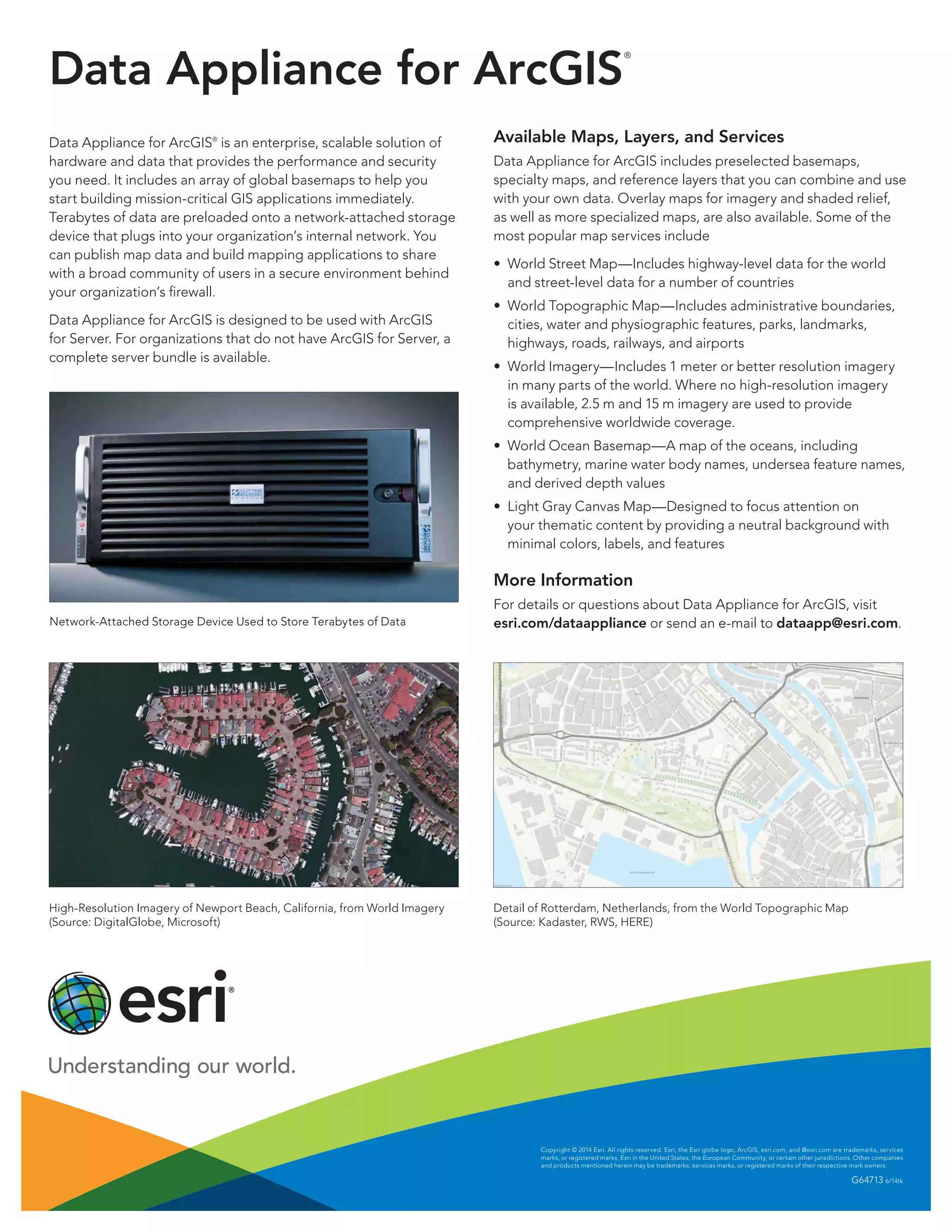
Data Appliance for ArcGIS
®
Data Appliance for ArcGIS®
is an enterprise, scalable solution of
hardware and data that provides the performance and security
you need. It includes an array of global basemaps to help you
start building mission-critical GIS applications immediately.
Terabytes of data are preloaded onto a network-attached storage
device that plugs into your organization’s internal network. You
can publish map data and build mapping applications to share
with a broad community of users in a secure environment behind
your organization’s firewall.
Data Appliance for ArcGIS is designed to be used with ArcGIS
for Server. For organizations that do not have ArcGIS for Server, a
complete server bundle is available.
Network-Attached Storage Device Used to Store Terabytes of Data
High-Resolution Imagery of Newport Beach, California, from World Imagery
(Source: DigitalGlobe, Microsoft)
Copyright © 2014 Esri. All rights reserved. Esri, the Esri globe logo, ArcGIS, esri.com, and @esri.com are trademarks, services
marks, or registered marks, Esri in the United States, the European Community, or certain other jurisdictions. Other companies
and products mentioned herein may be trademarks, services marks, or registered marks of their respective mark owners.
G64713 6/14tk
Available Maps, Layers, and Services
Data Appliance for ArcGIS includes preselected basemaps,
specialty maps, and reference layers that you can combine and use
with your own data. Overlay maps for imagery and shaded relief,
as well as more specialized maps, are also available. Some of the
most popular map services include
•	 World Street Map—Includes highway-level data for the world
and street-level data for a number of countries
•	 World Topographic Map—Includes administrative boundaries,
cities, water and physiographic features, parks, landmarks,
highways, roads, railways, and airports
•	 World Imagery—Includes 1 meter or better resolution imagery
in many parts of the world. Where no high-resolution imagery
is available, 2.5 m and 15 m imagery are used to provide
comprehensive worldwide coverage.
•	 World Ocean Basemap—A map of the oceans, including
bathymetry, marine water body names, undersea feature names,
and derived depth values
•	 Light Gray Canvas Map—Designed to focus attention on
your thematic content by providing a neutral background with
minimal colors, labels, and features
More Information
For details or questions about Data Appliance for ArcGIS, visit
esri.com/dataappliance or send an e-mail to dataapp@esri.com.
Detail of Rotterdam, Netherlands, from the World Topographic Map
(Source: Kadaster, RWS, HERE)

More Related Content

What's hot

HERE - Esri UK Annual Conference 2016
HERE - Esri UK Annual Conference 2016HERE - Esri UK Annual Conference 2016
HERE - Esri UK Annual Conference 2016Esri UK
 
Sys711 spatial-apps, presentation slide for Advanced Database Technology Subject
Sys711 spatial-apps, presentation slide for Advanced Database Technology SubjectSys711 spatial-apps, presentation slide for Advanced Database Technology Subject
Sys711 spatial-apps, presentation slide for Advanced Database Technology SubjectSyahman Mohamad
 
ArcGIS for Server on Microsoft Azure Jumpstart
ArcGIS for Server on Microsoft Azure JumpstartArcGIS for Server on Microsoft Azure Jumpstart
ArcGIS for Server on Microsoft Azure JumpstartEsri
 
brandonbal-afm_tech
brandonbal-afm_techbrandonbal-afm_tech
brandonbal-afm_techBrandon Bal
 
Open source web GIS
Open source web GISOpen source web GIS
Open source web GISShweta Ghate
 
GeoCollector for ArcGIS for Windows Mobile
GeoCollector for ArcGIS for Windows MobileGeoCollector for ArcGIS for Windows Mobile
GeoCollector for ArcGIS for Windows MobileEsri
 
Developing Efficient Web-based GIS Applications
Developing Efficient Web-based GIS ApplicationsDeveloping Efficient Web-based GIS Applications
Developing Efficient Web-based GIS ApplicationsSwetha A
 
Esri Geoportal Server
Esri Geoportal ServerEsri Geoportal Server
Esri Geoportal ServerEsri
 
Living Content - Smart Data - Esri UK Annual Conference 2017
Living Content - Smart Data - Esri UK Annual Conference 2017Living Content - Smart Data - Esri UK Annual Conference 2017
Living Content - Smart Data - Esri UK Annual Conference 2017Esri UK
 
Sharing information through web applications - Smart Collaboration - Esri UK ...
Sharing information through web applications - Smart Collaboration - Esri UK ...Sharing information through web applications - Smart Collaboration - Esri UK ...
Sharing information through web applications - Smart Collaboration - Esri UK ...Esri UK
 
Introduction to Apps for Smarter Working - Smart Working - Esri UK Annual Con...
Introduction to Apps for Smarter Working - Smart Working - Esri UK Annual Con...Introduction to Apps for Smarter Working - Smart Working - Esri UK Annual Con...
Introduction to Apps for Smarter Working - Smart Working - Esri UK Annual Con...Esri UK
 
Imagery and beyond - BK 2016
Imagery and beyond - BK 2016Imagery and beyond - BK 2016
Imagery and beyond - BK 2016Geodata AS
 
SEPA - Esri UK Annual Conference 2016
SEPA - Esri UK Annual Conference 2016SEPA - Esri UK Annual Conference 2016
SEPA - Esri UK Annual Conference 2016Esri UK
 
Free and Open Source GIS
Free and Open Source GISFree and Open Source GIS
Free and Open Source GISNico Elema
 
ArcGIS Open Data - Smart Data - Esri UK Annual Conference 2017
ArcGIS Open Data - Smart Data - Esri UK Annual Conference 2017ArcGIS Open Data - Smart Data - Esri UK Annual Conference 2017
ArcGIS Open Data - Smart Data - Esri UK Annual Conference 2017Esri UK
 
OGA - Esri UK Annual Conference 2016
OGA - Esri UK Annual Conference 2016OGA - Esri UK Annual Conference 2016
OGA - Esri UK Annual Conference 2016Esri UK
 
Computation of spatial data on Hadoop Cluster
Computation of spatial data on Hadoop ClusterComputation of spatial data on Hadoop Cluster
Computation of spatial data on Hadoop ClusterAbhishek Sagar
 
2015 FOSS4G Track: Analyzing Aspen's Community Forest with Lidar, Object-Base...
2015 FOSS4G Track: Analyzing Aspen's Community Forest with Lidar, Object-Base...2015 FOSS4G Track: Analyzing Aspen's Community Forest with Lidar, Object-Base...
2015 FOSS4G Track: Analyzing Aspen's Community Forest with Lidar, Object-Base...GIS in the Rockies
 

What's hot (20)

HERE - Esri UK Annual Conference 2016
HERE - Esri UK Annual Conference 2016HERE - Esri UK Annual Conference 2016
HERE - Esri UK Annual Conference 2016
 
Sys711 spatial-apps, presentation slide for Advanced Database Technology Subject
Sys711 spatial-apps, presentation slide for Advanced Database Technology SubjectSys711 spatial-apps, presentation slide for Advanced Database Technology Subject
Sys711 spatial-apps, presentation slide for Advanced Database Technology Subject
 
ArcGIS for Server on Microsoft Azure Jumpstart
ArcGIS for Server on Microsoft Azure JumpstartArcGIS for Server on Microsoft Azure Jumpstart
ArcGIS for Server on Microsoft Azure Jumpstart
 
brandonbal-afm_tech
brandonbal-afm_techbrandonbal-afm_tech
brandonbal-afm_tech
 
Open source web GIS
Open source web GISOpen source web GIS
Open source web GIS
 
GeoCollector for ArcGIS for Windows Mobile
GeoCollector for ArcGIS for Windows MobileGeoCollector for ArcGIS for Windows Mobile
GeoCollector for ArcGIS for Windows Mobile
 
Developing Efficient Web-based GIS Applications
Developing Efficient Web-based GIS ApplicationsDeveloping Efficient Web-based GIS Applications
Developing Efficient Web-based GIS Applications
 
Esri Geoportal Server
Esri Geoportal ServerEsri Geoportal Server
Esri Geoportal Server
 
Global mapper
Global mapperGlobal mapper
Global mapper
 
Living Content - Smart Data - Esri UK Annual Conference 2017
Living Content - Smart Data - Esri UK Annual Conference 2017Living Content - Smart Data - Esri UK Annual Conference 2017
Living Content - Smart Data - Esri UK Annual Conference 2017
 
Sharing information through web applications - Smart Collaboration - Esri UK ...
Sharing information through web applications - Smart Collaboration - Esri UK ...Sharing information through web applications - Smart Collaboration - Esri UK ...
Sharing information through web applications - Smart Collaboration - Esri UK ...
 
Introduction to Apps for Smarter Working - Smart Working - Esri UK Annual Con...
Introduction to Apps for Smarter Working - Smart Working - Esri UK Annual Con...Introduction to Apps for Smarter Working - Smart Working - Esri UK Annual Con...
Introduction to Apps for Smarter Working - Smart Working - Esri UK Annual Con...
 
Imagery and beyond - BK 2016
Imagery and beyond - BK 2016Imagery and beyond - BK 2016
Imagery and beyond - BK 2016
 
Isaac esri living atlas
Isaac esri living atlasIsaac esri living atlas
Isaac esri living atlas
 
SEPA - Esri UK Annual Conference 2016
SEPA - Esri UK Annual Conference 2016SEPA - Esri UK Annual Conference 2016
SEPA - Esri UK Annual Conference 2016
 
Free and Open Source GIS
Free and Open Source GISFree and Open Source GIS
Free and Open Source GIS
 
ArcGIS Open Data - Smart Data - Esri UK Annual Conference 2017
ArcGIS Open Data - Smart Data - Esri UK Annual Conference 2017ArcGIS Open Data - Smart Data - Esri UK Annual Conference 2017
ArcGIS Open Data - Smart Data - Esri UK Annual Conference 2017
 
OGA - Esri UK Annual Conference 2016
OGA - Esri UK Annual Conference 2016OGA - Esri UK Annual Conference 2016
OGA - Esri UK Annual Conference 2016
 
Computation of spatial data on Hadoop Cluster
Computation of spatial data on Hadoop ClusterComputation of spatial data on Hadoop Cluster
Computation of spatial data on Hadoop Cluster
 
2015 FOSS4G Track: Analyzing Aspen's Community Forest with Lidar, Object-Base...
2015 FOSS4G Track: Analyzing Aspen's Community Forest with Lidar, Object-Base...2015 FOSS4G Track: Analyzing Aspen's Community Forest with Lidar, Object-Base...
2015 FOSS4G Track: Analyzing Aspen's Community Forest with Lidar, Object-Base...
 

Similar to Data Appliance for ArcGIS

ArcGIS por
ArcGIS porArcGIS por
ArcGIS porWizoAli
 
ArcGIS
ArcGISArcGIS
ArcGISEsri
 
How ArcGIS for the Military Supports Maritime Operations
How ArcGIS for the Military Supports Maritime OperationsHow ArcGIS for the Military Supports Maritime Operations
How ArcGIS for the Military Supports Maritime OperationsEsri
 
What's New in the ArcGIS Platform - Smart Education - Higher - AC18
What's New in the ArcGIS Platform - Smart Education - Higher - AC18What's New in the ArcGIS Platform - Smart Education - Higher - AC18
What's New in the ArcGIS Platform - Smart Education - Higher - AC18Esri UK
 
ArcGIS
ArcGISArcGIS
ArcGISEsri
 
ArcGIS for the Military--Maritime Operations
ArcGIS for the Military--Maritime OperationsArcGIS for the Military--Maritime Operations
ArcGIS for the Military--Maritime OperationsEsri
 
ArcGIS 10.1 for Server Functionality Matrix
ArcGIS 10.1 for Server Functionality MatrixArcGIS 10.1 for Server Functionality Matrix
ArcGIS 10.1 for Server Functionality MatrixEsri
 
Esri News for Petroleum Winter 2013/2014 newsletter
Esri News for Petroleum Winter 2013/2014 newsletterEsri News for Petroleum Winter 2013/2014 newsletter
Esri News for Petroleum Winter 2013/2014 newsletterEsri
 
Arcgis server-functionality-matrix
Arcgis server-functionality-matrixArcgis server-functionality-matrix
Arcgis server-functionality-matrixEsri
 
ArcGIS 10.2 for Server Functionality Matrix
ArcGIS 10.2 for Server Functionality MatrixArcGIS 10.2 for Server Functionality Matrix
ArcGIS 10.2 for Server Functionality MatrixEsri
 
Architecting the ArcGIS Platform
Architecting the ArcGIS PlatformArchitecting the ArcGIS Platform
Architecting the ArcGIS PlatformEsri UK
 
Intro GIS.pptx
Intro GIS.pptxIntro GIS.pptx
Intro GIS.pptxSamiDan2
 
ArcGIS Online
ArcGIS OnlineArcGIS Online
ArcGIS OnlineEsri
 
Dsm Presentation
Dsm PresentationDsm Presentation
Dsm Presentationrichoe
 
FlightlineGeo_ESRI_Newsletter_winter2014
FlightlineGeo_ESRI_Newsletter_winter2014FlightlineGeo_ESRI_Newsletter_winter2014
FlightlineGeo_ESRI_Newsletter_winter2014Devon Humphrey
 
ArcGIS Online
ArcGIS OnlineArcGIS Online
ArcGIS OnlineEsri
 
Different GIS Software's (2).pptx
Different GIS Software's (2).pptxDifferent GIS Software's (2).pptx
Different GIS Software's (2).pptxlovezalodhi
 
Commercially use GIS & REMOTE SENSING Software
Commercially use GIS & REMOTE SENSING SoftwareCommercially use GIS & REMOTE SENSING Software
Commercially use GIS & REMOTE SENSING Softwareanuj4849
 
Implementing ArcGIS for Water Utilities
Implementing ArcGIS for Water UtilitiesImplementing ArcGIS for Water Utilities
Implementing ArcGIS for Water UtilitiesEsri
 

Similar to Data Appliance for ArcGIS (20)

ArcGIS por
ArcGIS porArcGIS por
ArcGIS por
 
ArcGIS
ArcGISArcGIS
ArcGIS
 
How ArcGIS for the Military Supports Maritime Operations
How ArcGIS for the Military Supports Maritime OperationsHow ArcGIS for the Military Supports Maritime Operations
How ArcGIS for the Military Supports Maritime Operations
 
What's New in the ArcGIS Platform - Smart Education - Higher - AC18
What's New in the ArcGIS Platform - Smart Education - Higher - AC18What's New in the ArcGIS Platform - Smart Education - Higher - AC18
What's New in the ArcGIS Platform - Smart Education - Higher - AC18
 
ArcGIS
ArcGISArcGIS
ArcGIS
 
ArcGIS for the Military--Maritime Operations
ArcGIS for the Military--Maritime OperationsArcGIS for the Military--Maritime Operations
ArcGIS for the Military--Maritime Operations
 
ArcGIS 10.1 for Server Functionality Matrix
ArcGIS 10.1 for Server Functionality MatrixArcGIS 10.1 for Server Functionality Matrix
ArcGIS 10.1 for Server Functionality Matrix
 
Esri News for Petroleum Winter 2013/2014 newsletter
Esri News for Petroleum Winter 2013/2014 newsletterEsri News for Petroleum Winter 2013/2014 newsletter
Esri News for Petroleum Winter 2013/2014 newsletter
 
Arcgis server-functionality-matrix
Arcgis server-functionality-matrixArcgis server-functionality-matrix
Arcgis server-functionality-matrix
 
ArcGIS 10.2 for Server Functionality Matrix
ArcGIS 10.2 for Server Functionality MatrixArcGIS 10.2 for Server Functionality Matrix
ArcGIS 10.2 for Server Functionality Matrix
 
Architecting the ArcGIS Platform
Architecting the ArcGIS PlatformArchitecting the ArcGIS Platform
Architecting the ArcGIS Platform
 
Intro GIS.pptx
Intro GIS.pptxIntro GIS.pptx
Intro GIS.pptx
 
ArcGIS Online
ArcGIS OnlineArcGIS Online
ArcGIS Online
 
Dsm Presentation
Dsm PresentationDsm Presentation
Dsm Presentation
 
Extension arc gis
Extension arc gisExtension arc gis
Extension arc gis
 
FlightlineGeo_ESRI_Newsletter_winter2014
FlightlineGeo_ESRI_Newsletter_winter2014FlightlineGeo_ESRI_Newsletter_winter2014
FlightlineGeo_ESRI_Newsletter_winter2014
 
ArcGIS Online
ArcGIS OnlineArcGIS Online
ArcGIS Online
 
Different GIS Software's (2).pptx
Different GIS Software's (2).pptxDifferent GIS Software's (2).pptx
Different GIS Software's (2).pptx
 
Commercially use GIS & REMOTE SENSING Software
Commercially use GIS & REMOTE SENSING SoftwareCommercially use GIS & REMOTE SENSING Software
Commercially use GIS & REMOTE SENSING Software
 
Implementing ArcGIS for Water Utilities
Implementing ArcGIS for Water UtilitiesImplementing ArcGIS for Water Utilities
Implementing ArcGIS for Water Utilities
 

More from Esri

INIA- CISA: Análisis de las amenazas en la fauna silvestre
INIA- CISA: Análisis de las amenazas en la fauna silvestreINIA- CISA: Análisis de las amenazas en la fauna silvestre
INIA- CISA: Análisis de las amenazas en la fauna silvestreEsri
 
Aena Aeropuerto Adolfo Suárez-Barajas crea potentes aplicaciones para sus cli...
Aena Aeropuerto Adolfo Suárez-Barajas crea potentes aplicaciones para sus cli...Aena Aeropuerto Adolfo Suárez-Barajas crea potentes aplicaciones para sus cli...
Aena Aeropuerto Adolfo Suárez-Barajas crea potentes aplicaciones para sus cli...Esri
 
Plataforma Smart City de Móstoles
Plataforma Smart City de MóstolesPlataforma Smart City de Móstoles
Plataforma Smart City de MóstolesEsri
 
ArcGIS Online para Organizaciones
ArcGIS Online para OrganizacionesArcGIS Online para Organizaciones
ArcGIS Online para OrganizacionesEsri
 
Molina de Segura se convierte en una smart city
Molina de Segura se convierte en una smart cityMolina de Segura se convierte en una smart city
Molina de Segura se convierte en una smart cityEsri
 
Portal for ArcGIS
Portal for ArcGISPortal for ArcGIS
Portal for ArcGISEsri
 
GIS-Based Web Services Provide Rapid Analysis and Dissemination of Maritime Data
GIS-Based Web Services Provide Rapid Analysis and Dissemination of Maritime DataGIS-Based Web Services Provide Rapid Analysis and Dissemination of Maritime Data
GIS-Based Web Services Provide Rapid Analysis and Dissemination of Maritime DataEsri
 
An Effective Tool for Drinking Water Protection
An Effective Tool for Drinking Water ProtectionAn Effective Tool for Drinking Water Protection
An Effective Tool for Drinking Water ProtectionEsri
 
Esri and BlackBridge
Esri and BlackBridgeEsri and BlackBridge
Esri and BlackBridgeEsri
 
Esri and AccuWeather
Esri and AccuWeatherEsri and AccuWeather
Esri and AccuWeatherEsri
 
Esri and Airbus Defense & Space
Esri and Airbus Defense & SpaceEsri and Airbus Defense & Space
Esri and Airbus Defense & SpaceEsri
 
Esri US Data Fact Sheet
Esri US Data Fact SheetEsri US Data Fact Sheet
Esri US Data Fact SheetEsri
 
ArcGIS GeoEvent Extension for Server
ArcGIS GeoEvent Extension for ServerArcGIS GeoEvent Extension for Server
ArcGIS GeoEvent Extension for ServerEsri
 
The NATO Core Geographic Services System
The NATO Core Geographic Services SystemThe NATO Core Geographic Services System
The NATO Core Geographic Services SystemEsri
 
ArcGIS for Desktop Tips and Shortcuts
ArcGIS for Desktop Tips and ShortcutsArcGIS for Desktop Tips and Shortcuts
ArcGIS for Desktop Tips and ShortcutsEsri
 
ArcGIS: A Platform for Intelligent 3D Imagery
ArcGIS: A Platform for Intelligent 3D ImageryArcGIS: A Platform for Intelligent 3D Imagery
ArcGIS: A Platform for Intelligent 3D ImageryEsri
 
Location Analytics for Banking
Location Analytics for BankingLocation Analytics for Banking
Location Analytics for BankingEsri
 
Esri CityEngine
Esri CityEngineEsri CityEngine
Esri CityEngineEsri
 
Boost Mining Profits with Esri
Boost Mining Profits with EsriBoost Mining Profits with Esri
Boost Mining Profits with EsriEsri
 
Qatar Enters a New Era of Emergency Response and Proactive Security
Qatar Enters a New Era of Emergency Response and Proactive SecurityQatar Enters a New Era of Emergency Response and Proactive Security
Qatar Enters a New Era of Emergency Response and Proactive SecurityEsri
 

More from Esri (20)

INIA- CISA: Análisis de las amenazas en la fauna silvestre
INIA- CISA: Análisis de las amenazas en la fauna silvestreINIA- CISA: Análisis de las amenazas en la fauna silvestre
INIA- CISA: Análisis de las amenazas en la fauna silvestre
 
Aena Aeropuerto Adolfo Suárez-Barajas crea potentes aplicaciones para sus cli...
Aena Aeropuerto Adolfo Suárez-Barajas crea potentes aplicaciones para sus cli...Aena Aeropuerto Adolfo Suárez-Barajas crea potentes aplicaciones para sus cli...
Aena Aeropuerto Adolfo Suárez-Barajas crea potentes aplicaciones para sus cli...
 
Plataforma Smart City de Móstoles
Plataforma Smart City de MóstolesPlataforma Smart City de Móstoles
Plataforma Smart City de Móstoles
 
ArcGIS Online para Organizaciones
ArcGIS Online para OrganizacionesArcGIS Online para Organizaciones
ArcGIS Online para Organizaciones
 
Molina de Segura se convierte en una smart city
Molina de Segura se convierte en una smart cityMolina de Segura se convierte en una smart city
Molina de Segura se convierte en una smart city
 
Portal for ArcGIS
Portal for ArcGISPortal for ArcGIS
Portal for ArcGIS
 
GIS-Based Web Services Provide Rapid Analysis and Dissemination of Maritime Data
GIS-Based Web Services Provide Rapid Analysis and Dissemination of Maritime DataGIS-Based Web Services Provide Rapid Analysis and Dissemination of Maritime Data
GIS-Based Web Services Provide Rapid Analysis and Dissemination of Maritime Data
 
An Effective Tool for Drinking Water Protection
An Effective Tool for Drinking Water ProtectionAn Effective Tool for Drinking Water Protection
An Effective Tool for Drinking Water Protection
 
Esri and BlackBridge
Esri and BlackBridgeEsri and BlackBridge
Esri and BlackBridge
 
Esri and AccuWeather
Esri and AccuWeatherEsri and AccuWeather
Esri and AccuWeather
 
Esri and Airbus Defense & Space
Esri and Airbus Defense & SpaceEsri and Airbus Defense & Space
Esri and Airbus Defense & Space
 
Esri US Data Fact Sheet
Esri US Data Fact SheetEsri US Data Fact Sheet
Esri US Data Fact Sheet
 
ArcGIS GeoEvent Extension for Server
ArcGIS GeoEvent Extension for ServerArcGIS GeoEvent Extension for Server
ArcGIS GeoEvent Extension for Server
 
The NATO Core Geographic Services System
The NATO Core Geographic Services SystemThe NATO Core Geographic Services System
The NATO Core Geographic Services System
 
ArcGIS for Desktop Tips and Shortcuts
ArcGIS for Desktop Tips and ShortcutsArcGIS for Desktop Tips and Shortcuts
ArcGIS for Desktop Tips and Shortcuts
 
ArcGIS: A Platform for Intelligent 3D Imagery
ArcGIS: A Platform for Intelligent 3D ImageryArcGIS: A Platform for Intelligent 3D Imagery
ArcGIS: A Platform for Intelligent 3D Imagery
 
Location Analytics for Banking
Location Analytics for BankingLocation Analytics for Banking
Location Analytics for Banking
 
Esri CityEngine
Esri CityEngineEsri CityEngine
Esri CityEngine
 
Boost Mining Profits with Esri
Boost Mining Profits with EsriBoost Mining Profits with Esri
Boost Mining Profits with Esri
 
Qatar Enters a New Era of Emergency Response and Proactive Security
Qatar Enters a New Era of Emergency Response and Proactive SecurityQatar Enters a New Era of Emergency Response and Proactive Security
Qatar Enters a New Era of Emergency Response and Proactive Security
 

Recently uploaded

Injustice - Developers Among Us (SciFiDevCon 2024)
Injustice - Developers Among Us (SciFiDevCon 2024)Injustice - Developers Among Us (SciFiDevCon 2024)
Injustice - Developers Among Us (SciFiDevCon 2024)Allon Mureinik
 
Unblocking The Main Thread Solving ANRs and Frozen Frames
Unblocking The Main Thread Solving ANRs and Frozen FramesUnblocking The Main Thread Solving ANRs and Frozen Frames
Unblocking The Main Thread Solving ANRs and Frozen FramesSinan KOZAK
 
My Hashitalk Indonesia April 2024 Presentation
My Hashitalk Indonesia April 2024 PresentationMy Hashitalk Indonesia April 2024 Presentation
My Hashitalk Indonesia April 2024 PresentationRidwan Fadjar
 
SIEMENS: RAPUNZEL – A Tale About Knowledge Graph
SIEMENS: RAPUNZEL – A Tale About Knowledge GraphSIEMENS: RAPUNZEL – A Tale About Knowledge Graph
SIEMENS: RAPUNZEL – A Tale About Knowledge GraphNeo4j
 
WhatsApp 9892124323 ✓Call Girls In Kalyan ( Mumbai ) secure service
WhatsApp 9892124323 ✓Call Girls In Kalyan ( Mumbai ) secure serviceWhatsApp 9892124323 ✓Call Girls In Kalyan ( Mumbai ) secure service
WhatsApp 9892124323 ✓Call Girls In Kalyan ( Mumbai ) secure servicePooja Nehwal
 
SQL Database Design For Developers at php[tek] 2024
SQL Database Design For Developers at php[tek] 2024SQL Database Design For Developers at php[tek] 2024
SQL Database Design For Developers at php[tek] 2024Scott Keck-Warren
 
Artificial intelligence in the post-deep learning era
Artificial intelligence in the post-deep learning eraArtificial intelligence in the post-deep learning era
Artificial intelligence in the post-deep learning eraDeakin University
 
08448380779 Call Girls In Civil Lines Women Seeking Men
08448380779 Call Girls In Civil Lines Women Seeking Men08448380779 Call Girls In Civil Lines Women Seeking Men
08448380779 Call Girls In Civil Lines Women Seeking MenDelhi Call girls
 
How to convert PDF to text with Nanonets
How to convert PDF to text with NanonetsHow to convert PDF to text with Nanonets
How to convert PDF to text with Nanonetsnaman860154
 
Transcript: #StandardsGoals for 2024: What’s new for BISAC - Tech Forum 2024
Transcript: #StandardsGoals for 2024: What’s new for BISAC - Tech Forum 2024Transcript: #StandardsGoals for 2024: What’s new for BISAC - Tech Forum 2024
Transcript: #StandardsGoals for 2024: What’s new for BISAC - Tech Forum 2024BookNet Canada
 
Advanced Test Driven-Development @ php[tek] 2024
Advanced Test Driven-Development @ php[tek] 2024Advanced Test Driven-Development @ php[tek] 2024
Advanced Test Driven-Development @ php[tek] 2024Scott Keck-Warren
 
Enhancing Worker Digital Experience: A Hands-on Workshop for Partners
Enhancing Worker Digital Experience: A Hands-on Workshop for PartnersEnhancing Worker Digital Experience: A Hands-on Workshop for Partners
Enhancing Worker Digital Experience: A Hands-on Workshop for PartnersThousandEyes
 
GenCyber Cyber Security Day Presentation
GenCyber Cyber Security Day PresentationGenCyber Cyber Security Day Presentation
GenCyber Cyber Security Day PresentationMichael W. Hawkins
 
Understanding the Laravel MVC Architecture
Understanding the Laravel MVC ArchitectureUnderstanding the Laravel MVC Architecture
Understanding the Laravel MVC ArchitecturePixlogix Infotech
 
08448380779 Call Girls In Diplomatic Enclave Women Seeking Men
08448380779 Call Girls In Diplomatic Enclave Women Seeking Men08448380779 Call Girls In Diplomatic Enclave Women Seeking Men
08448380779 Call Girls In Diplomatic Enclave Women Seeking MenDelhi Call girls
 
Presentation on how to chat with PDF using ChatGPT code interpreter
Presentation on how to chat with PDF using ChatGPT code interpreterPresentation on how to chat with PDF using ChatGPT code interpreter
Presentation on how to chat with PDF using ChatGPT code interpreternaman860154
 
Neo4j - How KGs are shaping the future of Generative AI at AWS Summit London ...
Neo4j - How KGs are shaping the future of Generative AI at AWS Summit London ...Neo4j - How KGs are shaping the future of Generative AI at AWS Summit London ...
Neo4j - How KGs are shaping the future of Generative AI at AWS Summit London ...Neo4j
 
Snow Chain-Integrated Tire for a Safe Drive on Winter Roads
Snow Chain-Integrated Tire for a Safe Drive on Winter RoadsSnow Chain-Integrated Tire for a Safe Drive on Winter Roads
Snow Chain-Integrated Tire for a Safe Drive on Winter RoadsHyundai Motor Group
 
Kotlin Multiplatform & Compose Multiplatform - Starter kit for pragmatics
Kotlin Multiplatform & Compose Multiplatform - Starter kit for pragmaticsKotlin Multiplatform & Compose Multiplatform - Starter kit for pragmatics
Kotlin Multiplatform & Compose Multiplatform - Starter kit for pragmaticscarlostorres15106
 
CloudStudio User manual (basic edition):
CloudStudio User manual (basic edition):CloudStudio User manual (basic edition):
CloudStudio User manual (basic edition):comworks
 

Recently uploaded (20)

Injustice - Developers Among Us (SciFiDevCon 2024)
Injustice - Developers Among Us (SciFiDevCon 2024)Injustice - Developers Among Us (SciFiDevCon 2024)
Injustice - Developers Among Us (SciFiDevCon 2024)
 
Unblocking The Main Thread Solving ANRs and Frozen Frames
Unblocking The Main Thread Solving ANRs and Frozen FramesUnblocking The Main Thread Solving ANRs and Frozen Frames
Unblocking The Main Thread Solving ANRs and Frozen Frames
 
My Hashitalk Indonesia April 2024 Presentation
My Hashitalk Indonesia April 2024 PresentationMy Hashitalk Indonesia April 2024 Presentation
My Hashitalk Indonesia April 2024 Presentation
 
SIEMENS: RAPUNZEL – A Tale About Knowledge Graph
SIEMENS: RAPUNZEL – A Tale About Knowledge GraphSIEMENS: RAPUNZEL – A Tale About Knowledge Graph
SIEMENS: RAPUNZEL – A Tale About Knowledge Graph
 
WhatsApp 9892124323 ✓Call Girls In Kalyan ( Mumbai ) secure service
WhatsApp 9892124323 ✓Call Girls In Kalyan ( Mumbai ) secure serviceWhatsApp 9892124323 ✓Call Girls In Kalyan ( Mumbai ) secure service
WhatsApp 9892124323 ✓Call Girls In Kalyan ( Mumbai ) secure service
 
SQL Database Design For Developers at php[tek] 2024
SQL Database Design For Developers at php[tek] 2024SQL Database Design For Developers at php[tek] 2024
SQL Database Design For Developers at php[tek] 2024
 
Artificial intelligence in the post-deep learning era
Artificial intelligence in the post-deep learning eraArtificial intelligence in the post-deep learning era
Artificial intelligence in the post-deep learning era
 
08448380779 Call Girls In Civil Lines Women Seeking Men
08448380779 Call Girls In Civil Lines Women Seeking Men08448380779 Call Girls In Civil Lines Women Seeking Men
08448380779 Call Girls In Civil Lines Women Seeking Men
 
How to convert PDF to text with Nanonets
How to convert PDF to text with NanonetsHow to convert PDF to text with Nanonets
How to convert PDF to text with Nanonets
 
Transcript: #StandardsGoals for 2024: What’s new for BISAC - Tech Forum 2024
Transcript: #StandardsGoals for 2024: What’s new for BISAC - Tech Forum 2024Transcript: #StandardsGoals for 2024: What’s new for BISAC - Tech Forum 2024
Transcript: #StandardsGoals for 2024: What’s new for BISAC - Tech Forum 2024
 
Advanced Test Driven-Development @ php[tek] 2024
Advanced Test Driven-Development @ php[tek] 2024Advanced Test Driven-Development @ php[tek] 2024
Advanced Test Driven-Development @ php[tek] 2024
 
Enhancing Worker Digital Experience: A Hands-on Workshop for Partners
Enhancing Worker Digital Experience: A Hands-on Workshop for PartnersEnhancing Worker Digital Experience: A Hands-on Workshop for Partners
Enhancing Worker Digital Experience: A Hands-on Workshop for Partners
 
GenCyber Cyber Security Day Presentation
GenCyber Cyber Security Day PresentationGenCyber Cyber Security Day Presentation
GenCyber Cyber Security Day Presentation
 
Understanding the Laravel MVC Architecture
Understanding the Laravel MVC ArchitectureUnderstanding the Laravel MVC Architecture
Understanding the Laravel MVC Architecture
 
08448380779 Call Girls In Diplomatic Enclave Women Seeking Men
08448380779 Call Girls In Diplomatic Enclave Women Seeking Men08448380779 Call Girls In Diplomatic Enclave Women Seeking Men
08448380779 Call Girls In Diplomatic Enclave Women Seeking Men
 
Presentation on how to chat with PDF using ChatGPT code interpreter
Presentation on how to chat with PDF using ChatGPT code interpreterPresentation on how to chat with PDF using ChatGPT code interpreter
Presentation on how to chat with PDF using ChatGPT code interpreter
 
Neo4j - How KGs are shaping the future of Generative AI at AWS Summit London ...
Neo4j - How KGs are shaping the future of Generative AI at AWS Summit London ...Neo4j - How KGs are shaping the future of Generative AI at AWS Summit London ...
Neo4j - How KGs are shaping the future of Generative AI at AWS Summit London ...
 
Snow Chain-Integrated Tire for a Safe Drive on Winter Roads
Snow Chain-Integrated Tire for a Safe Drive on Winter RoadsSnow Chain-Integrated Tire for a Safe Drive on Winter Roads
Snow Chain-Integrated Tire for a Safe Drive on Winter Roads
 
Kotlin Multiplatform & Compose Multiplatform - Starter kit for pragmatics
Kotlin Multiplatform & Compose Multiplatform - Starter kit for pragmaticsKotlin Multiplatform & Compose Multiplatform - Starter kit for pragmatics
Kotlin Multiplatform & Compose Multiplatform - Starter kit for pragmatics
 
CloudStudio User manual (basic edition):
CloudStudio User manual (basic edition):CloudStudio User manual (basic edition):
CloudStudio User manual (basic edition):
 

Data Appliance for ArcGIS

  • 1. Data Appliance for ArcGIS ® Data Appliance for ArcGIS® is an enterprise, scalable solution of hardware and data that provides the performance and security you need. It includes an array of global basemaps to help you start building mission-critical GIS applications immediately. Terabytes of data are preloaded onto a network-attached storage device that plugs into your organization’s internal network. You can publish map data and build mapping applications to share with a broad community of users in a secure environment behind your organization’s firewall. Data Appliance for ArcGIS is designed to be used with ArcGIS for Server. For organizations that do not have ArcGIS for Server, a complete server bundle is available. Network-Attached Storage Device Used to Store Terabytes of Data High-Resolution Imagery of Newport Beach, California, from World Imagery (Source: DigitalGlobe, Microsoft) Copyright © 2014 Esri. All rights reserved. Esri, the Esri globe logo, ArcGIS, esri.com, and @esri.com are trademarks, services marks, or registered marks, Esri in the United States, the European Community, or certain other jurisdictions. Other companies and products mentioned herein may be trademarks, services marks, or registered marks of their respective mark owners. G64713 6/14tk Available Maps, Layers, and Services Data Appliance for ArcGIS includes preselected basemaps, specialty maps, and reference layers that you can combine and use with your own data. Overlay maps for imagery and shaded relief, as well as more specialized maps, are also available. Some of the most popular map services include • World Street Map—Includes highway-level data for the world and street-level data for a number of countries • World Topographic Map—Includes administrative boundaries, cities, water and physiographic features, parks, landmarks, highways, roads, railways, and airports • World Imagery—Includes 1 meter or better resolution imagery in many parts of the world. Where no high-resolution imagery is available, 2.5 m and 15 m imagery are used to provide comprehensive worldwide coverage. • World Ocean Basemap—A map of the oceans, including bathymetry, marine water body names, undersea feature names, and derived depth values • Light Gray Canvas Map—Designed to focus attention on your thematic content by providing a neutral background with minimal colors, labels, and features More Information For details or questions about Data Appliance for ArcGIS, visit esri.com/dataappliance or send an e-mail to dataapp@esri.com. Detail of Rotterdam, Netherlands, from the World Topographic Map (Source: Kadaster, RWS, HERE)