SlideShare a Scribd company logo
1 of 1
Download to read offline
Implementation of a geographic information systems (GIS)-based system
   to evaluate the visual impact of offshore renewable energy installations
                                           Chad Cooper – Center for Advanced Spatial Technologies (CAST), Jackson Cothren – CAST,
                                       Robert Sullivan – Argonne National Laboratory, Malcolm Williamson – CAST, Snow Winters – CAST,
                                                    David Ball – Department of Interior, Bureau of Ocean Energy Management


                           Introduction                                                                              Requirements
The United States Department of Interior's Bureau of Ocean Energy                               The system must:
Management (BOEM) faces increasing interest in the use of waters under its                      · Enable spatial design of offshore facility
jurisdiction for offshore renewable energy development. The Visual Impact
                                                                                                · Import geospatial data
Evaluation System for Offshore Renewable Energy, or VIESORE, is a GIS-
                                                                                                · Allow user control of atmospheric, lighting, and wave conditions
based application which allows BOEM staff to import or interactively design
the spatial layout and content of an offshore facility, import and prepare                      · Generate spatially accurate and realistic visualizations
geospatial data that will affect visibility, run a series of visual analyses which              · Output reports and images
take into account earth curvature, define atmospheric, lighting and wave                        · Provide a user-friendly interface
conditions and, finally generate one or a series of realistic visualizations from               It shall enable users to:
multiple viewpoints.
                                                                                                · Independently evaluate visual impact of proposed facilities
                                                                                                · Validate photomontages provided by vendors


                              Approach                                                                               System design
     3D visualizations through a customized familiar                                                Inputs/user               Visualization                  Outputs
                                                                                                    interaction                processing
                       GIS interface
                                                                                                                                                   Renders        Reports
                                                                                               ArcGIS 10


                                                                                                                         IS
                                                                                                                  ol rcG
                                                                                                               to A
                                                                                                                  om

                                                                                                                    s
      ArcGIS                    code             3D modeling


                                                                                                                st
                                                                                                                                                                    PDF

                                                                                                             Cu
                                                                                                                                                     JPG

· Vue Infinite 10 3D modeling software accessed in background batch
 mode through Python programming language via customized, yet
 familiar Esri ArcGIS interface
                                                                                                                                                                   HTML
· Vue provides photorealistic renderings
· User sets up real-world project data in ArcGIS interface, all data and                                                                           AVI
                                                                                                 GIS data inputs
 settings get passed to Vue where visualizations are then created
· Users familiar with ArcGIS interface – this eliminates need to learn
 Vue 3D software package


                Development to date                                                                                 Current results
· Import GIS data into Vue 3D visualization program                                             · Creation of photorealistic visualization renderings of planned
                                                                 All done in
· Import wind turbine generator 3D models                      background via
                                                                                                 offshore renewable energy installations
· Set camera and sun positions                                 custom Python                    · Successful import of real-world GIS data into Vue 3D software
                                                                     code
· Render to image (jpg)                                                                          package for use in visualizations
                                                                                                · User provided with friendly interface which allows them to import
               ArcGIS 10
                                                                                                 data


                              Planned
                              installation


                           Key observation
                             point (KOP)

More Related Content

Similar to Implementation of a geographic information systems (GIS)-based system to evaluate the visual impact of offshore renewable energy installations

Validating a smartphone-based pedestrian navigation system prototype - An inf...
Validating a smartphone-based pedestrian navigation system prototype - An inf...Validating a smartphone-based pedestrian navigation system prototype - An inf...
Validating a smartphone-based pedestrian navigation system prototype - An inf...Beniamino Murgante
 
Availability of Mobile Augmented Reality System for Urban Landscape Simulation
Availability of Mobile Augmented Reality System for Urban Landscape SimulationAvailability of Mobile Augmented Reality System for Urban Landscape Simulation
Availability of Mobile Augmented Reality System for Urban Landscape SimulationTomohiro Fukuda
 
g Eclipse @ Eclipse Summit Europe 2008
g Eclipse @ Eclipse Summit Europe 2008g Eclipse @ Eclipse Summit Europe 2008
g Eclipse @ Eclipse Summit Europe 2008guest462d7
 
[03 1][gpu용 개발자 도구 - parallel nsight 및 axe] miller axe
[03 1][gpu용 개발자 도구 - parallel nsight 및 axe] miller axe[03 1][gpu용 개발자 도구 - parallel nsight 및 axe] miller axe
[03 1][gpu용 개발자 도구 - parallel nsight 및 axe] miller axelaparuma
 
GOAR: GIS Oriented Mobile Augmented Reality for Urban Landscape Assessment
GOAR: GIS Oriented Mobile Augmented Reality for Urban Landscape AssessmentGOAR: GIS Oriented Mobile Augmented Reality for Urban Landscape Assessment
GOAR: GIS Oriented Mobile Augmented Reality for Urban Landscape AssessmentTomohiro Fukuda
 
Enterprise GIS
Enterprise GIS Enterprise GIS
Enterprise GIS Esri
 
GIS Based Project Planning and Management
GIS Based Project Planning and ManagementGIS Based Project Planning and Management
GIS Based Project Planning and ManagementSaurabhChobe
 
Handheld augmented reality_for_underground_infrast
Handheld augmented reality_for_underground_infrastHandheld augmented reality_for_underground_infrast
Handheld augmented reality_for_underground_infrastHelloWorld121381
 
Venus-c: Using open source clouds in eScience
Venus-c: Using open source clouds in eScienceVenus-c: Using open source clouds in eScience
Venus-c: Using open source clouds in eScienceOW2
 
Current State of mago3D, an Open Source Based Digital Twin Platform
Current State of mago3D, an Open Source Based Digital Twin PlatformCurrent State of mago3D, an Open Source Based Digital Twin Platform
Current State of mago3D, an Open Source Based Digital Twin PlatformSANGHEE SHIN
 
Integrating GIS to financial data
Integrating GIS to financial dataIntegrating GIS to financial data
Integrating GIS to financial dataeventspat
 
“Tools for Creating Next-Gen Computer Vision Apps on Snapdragon,” a Presentat...
“Tools for Creating Next-Gen Computer Vision Apps on Snapdragon,” a Presentat...“Tools for Creating Next-Gen Computer Vision Apps on Snapdragon,” a Presentat...
“Tools for Creating Next-Gen Computer Vision Apps on Snapdragon,” a Presentat...Edge AI and Vision Alliance
 
IMGS Local Gov User Group Presentation
IMGS Local Gov User Group PresentationIMGS Local Gov User Group Presentation
IMGS Local Gov User Group PresentationIMGS
 
BIM - Esri UK Annual Conference 2016
BIM - Esri UK Annual Conference 2016BIM - Esri UK Annual Conference 2016
BIM - Esri UK Annual Conference 2016Esri UK
 
Breizhcamp Rennes 2011
Breizhcamp Rennes 2011Breizhcamp Rennes 2011
Breizhcamp Rennes 2011sekond0
 

Similar to Implementation of a geographic information systems (GIS)-based system to evaluate the visual impact of offshore renewable energy installations (20)

Validating a smartphone-based pedestrian navigation system prototype - An inf...
Validating a smartphone-based pedestrian navigation system prototype - An inf...Validating a smartphone-based pedestrian navigation system prototype - An inf...
Validating a smartphone-based pedestrian navigation system prototype - An inf...
 
Availability of Mobile Augmented Reality System for Urban Landscape Simulation
Availability of Mobile Augmented Reality System for Urban Landscape SimulationAvailability of Mobile Augmented Reality System for Urban Landscape Simulation
Availability of Mobile Augmented Reality System for Urban Landscape Simulation
 
g Eclipse @ Eclipse Summit Europe 2008
g Eclipse @ Eclipse Summit Europe 2008g Eclipse @ Eclipse Summit Europe 2008
g Eclipse @ Eclipse Summit Europe 2008
 
[03 1][gpu용 개발자 도구 - parallel nsight 및 axe] miller axe
[03 1][gpu용 개발자 도구 - parallel nsight 및 axe] miller axe[03 1][gpu용 개발자 도구 - parallel nsight 및 axe] miller axe
[03 1][gpu용 개발자 도구 - parallel nsight 및 axe] miller axe
 
GOAR: GIS Oriented Mobile Augmented Reality for Urban Landscape Assessment
GOAR: GIS Oriented Mobile Augmented Reality for Urban Landscape AssessmentGOAR: GIS Oriented Mobile Augmented Reality for Urban Landscape Assessment
GOAR: GIS Oriented Mobile Augmented Reality for Urban Landscape Assessment
 
Enterprise GIS
Enterprise GIS Enterprise GIS
Enterprise GIS
 
vishal resume (1)
vishal resume (1)vishal resume (1)
vishal resume (1)
 
Geospatial Product Watch 2015
Geospatial Product Watch 2015Geospatial Product Watch 2015
Geospatial Product Watch 2015
 
GIS Based Project Planning and Management
GIS Based Project Planning and ManagementGIS Based Project Planning and Management
GIS Based Project Planning and Management
 
Handheld augmented reality_for_underground_infrast
Handheld augmented reality_for_underground_infrastHandheld augmented reality_for_underground_infrast
Handheld augmented reality_for_underground_infrast
 
Tg samsung 01
Tg samsung 01Tg samsung 01
Tg samsung 01
 
Osgis sept2012 cartogrammar
Osgis sept2012  cartogrammarOsgis sept2012  cartogrammar
Osgis sept2012 cartogrammar
 
Venus-c: Using open source clouds in eScience
Venus-c: Using open source clouds in eScienceVenus-c: Using open source clouds in eScience
Venus-c: Using open source clouds in eScience
 
Current State of mago3D, an Open Source Based Digital Twin Platform
Current State of mago3D, an Open Source Based Digital Twin PlatformCurrent State of mago3D, an Open Source Based Digital Twin Platform
Current State of mago3D, an Open Source Based Digital Twin Platform
 
Integrating GIS to financial data
Integrating GIS to financial dataIntegrating GIS to financial data
Integrating GIS to financial data
 
“Tools for Creating Next-Gen Computer Vision Apps on Snapdragon,” a Presentat...
“Tools for Creating Next-Gen Computer Vision Apps on Snapdragon,” a Presentat...“Tools for Creating Next-Gen Computer Vision Apps on Snapdragon,” a Presentat...
“Tools for Creating Next-Gen Computer Vision Apps on Snapdragon,” a Presentat...
 
IMGS Local Gov User Group Presentation
IMGS Local Gov User Group PresentationIMGS Local Gov User Group Presentation
IMGS Local Gov User Group Presentation
 
BIM - Esri UK Annual Conference 2016
BIM - Esri UK Annual Conference 2016BIM - Esri UK Annual Conference 2016
BIM - Esri UK Annual Conference 2016
 
Breizhcamp Rennes 2011
Breizhcamp Rennes 2011Breizhcamp Rennes 2011
Breizhcamp Rennes 2011
 
CV-RAKESH KUMAR
CV-RAKESH KUMARCV-RAKESH KUMAR
CV-RAKESH KUMAR
 

More from Chad Cooper

VIESORE - Visual Impact Evaluation System for Offshore Renewable Energy
VIESORE - Visual Impact Evaluation System for Offshore Renewable EnergyVIESORE - Visual Impact Evaluation System for Offshore Renewable Energy
VIESORE - Visual Impact Evaluation System for Offshore Renewable EnergyChad Cooper
 
VIESORE: Visual Impact Evaluation System for Offshore Renewable Energy
VIESORE: Visual Impact Evaluation System for Offshore Renewable EnergyVIESORE: Visual Impact Evaluation System for Offshore Renewable Energy
VIESORE: Visual Impact Evaluation System for Offshore Renewable EnergyChad Cooper
 
Advanced geoprocessing with Python
Advanced geoprocessing with PythonAdvanced geoprocessing with Python
Advanced geoprocessing with PythonChad Cooper
 
Reading and writing spatial data for the non-spatial programmer
Reading and writing spatial data for the non-spatial programmerReading and writing spatial data for the non-spatial programmer
Reading and writing spatial data for the non-spatial programmerChad Cooper
 
IPAS: An ArcGIS Server-based framework for oil and gas E and P decision support
IPAS: An ArcGIS Server-based framework for oil and gas E and P decision supportIPAS: An ArcGIS Server-based framework for oil and gas E and P decision support
IPAS: An ArcGIS Server-based framework for oil and gas E and P decision supportChad Cooper
 
Water resources and hydrochemistry of the Alluvial and Sparta aquifers of the...
Water resources and hydrochemistry of the Alluvial and Sparta aquifers of the...Water resources and hydrochemistry of the Alluvial and Sparta aquifers of the...
Water resources and hydrochemistry of the Alluvial and Sparta aquifers of the...Chad Cooper
 
Python And GIS - Beyond Modelbuilder And Pythonwin
Python And GIS - Beyond Modelbuilder And PythonwinPython And GIS - Beyond Modelbuilder And Pythonwin
Python And GIS - Beyond Modelbuilder And PythonwinChad Cooper
 

More from Chad Cooper (7)

VIESORE - Visual Impact Evaluation System for Offshore Renewable Energy
VIESORE - Visual Impact Evaluation System for Offshore Renewable EnergyVIESORE - Visual Impact Evaluation System for Offshore Renewable Energy
VIESORE - Visual Impact Evaluation System for Offshore Renewable Energy
 
VIESORE: Visual Impact Evaluation System for Offshore Renewable Energy
VIESORE: Visual Impact Evaluation System for Offshore Renewable EnergyVIESORE: Visual Impact Evaluation System for Offshore Renewable Energy
VIESORE: Visual Impact Evaluation System for Offshore Renewable Energy
 
Advanced geoprocessing with Python
Advanced geoprocessing with PythonAdvanced geoprocessing with Python
Advanced geoprocessing with Python
 
Reading and writing spatial data for the non-spatial programmer
Reading and writing spatial data for the non-spatial programmerReading and writing spatial data for the non-spatial programmer
Reading and writing spatial data for the non-spatial programmer
 
IPAS: An ArcGIS Server-based framework for oil and gas E and P decision support
IPAS: An ArcGIS Server-based framework for oil and gas E and P decision supportIPAS: An ArcGIS Server-based framework for oil and gas E and P decision support
IPAS: An ArcGIS Server-based framework for oil and gas E and P decision support
 
Water resources and hydrochemistry of the Alluvial and Sparta aquifers of the...
Water resources and hydrochemistry of the Alluvial and Sparta aquifers of the...Water resources and hydrochemistry of the Alluvial and Sparta aquifers of the...
Water resources and hydrochemistry of the Alluvial and Sparta aquifers of the...
 
Python And GIS - Beyond Modelbuilder And Pythonwin
Python And GIS - Beyond Modelbuilder And PythonwinPython And GIS - Beyond Modelbuilder And Pythonwin
Python And GIS - Beyond Modelbuilder And Pythonwin
 

Recently uploaded

08448380779 Call Girls In Friends Colony Women Seeking Men
08448380779 Call Girls In Friends Colony Women Seeking Men08448380779 Call Girls In Friends Colony Women Seeking Men
08448380779 Call Girls In Friends Colony Women Seeking MenDelhi Call girls
 
Beyond Boundaries: Leveraging No-Code Solutions for Industry Innovation
Beyond Boundaries: Leveraging No-Code Solutions for Industry InnovationBeyond Boundaries: Leveraging No-Code Solutions for Industry Innovation
Beyond Boundaries: Leveraging No-Code Solutions for Industry InnovationSafe Software
 
Scaling API-first – The story of a global engineering organization
Scaling API-first – The story of a global engineering organizationScaling API-first – The story of a global engineering organization
Scaling API-first – The story of a global engineering organizationRadu Cotescu
 
Presentation on how to chat with PDF using ChatGPT code interpreter
Presentation on how to chat with PDF using ChatGPT code interpreterPresentation on how to chat with PDF using ChatGPT code interpreter
Presentation on how to chat with PDF using ChatGPT code interpreternaman860154
 
08448380779 Call Girls In Civil Lines Women Seeking Men
08448380779 Call Girls In Civil Lines Women Seeking Men08448380779 Call Girls In Civil Lines Women Seeking Men
08448380779 Call Girls In Civil Lines Women Seeking MenDelhi Call girls
 
Kotlin Multiplatform & Compose Multiplatform - Starter kit for pragmatics
Kotlin Multiplatform & Compose Multiplatform - Starter kit for pragmaticsKotlin Multiplatform & Compose Multiplatform - Starter kit for pragmatics
Kotlin Multiplatform & Compose Multiplatform - Starter kit for pragmaticscarlostorres15106
 
SIEMENS: RAPUNZEL – A Tale About Knowledge Graph
SIEMENS: RAPUNZEL – A Tale About Knowledge GraphSIEMENS: RAPUNZEL – A Tale About Knowledge Graph
SIEMENS: RAPUNZEL – A Tale About Knowledge GraphNeo4j
 
Slack Application Development 101 Slides
Slack Application Development 101 SlidesSlack Application Development 101 Slides
Slack Application Development 101 Slidespraypatel2
 
Automating Business Process via MuleSoft Composer | Bangalore MuleSoft Meetup...
Automating Business Process via MuleSoft Composer | Bangalore MuleSoft Meetup...Automating Business Process via MuleSoft Composer | Bangalore MuleSoft Meetup...
Automating Business Process via MuleSoft Composer | Bangalore MuleSoft Meetup...shyamraj55
 
Unblocking The Main Thread Solving ANRs and Frozen Frames
Unblocking The Main Thread Solving ANRs and Frozen FramesUnblocking The Main Thread Solving ANRs and Frozen Frames
Unblocking The Main Thread Solving ANRs and Frozen FramesSinan KOZAK
 
AI as an Interface for Commercial Buildings
AI as an Interface for Commercial BuildingsAI as an Interface for Commercial Buildings
AI as an Interface for Commercial BuildingsMemoori
 
GenCyber Cyber Security Day Presentation
GenCyber Cyber Security Day PresentationGenCyber Cyber Security Day Presentation
GenCyber Cyber Security Day PresentationMichael W. Hawkins
 
Tech-Forward - Achieving Business Readiness For Copilot in Microsoft 365
Tech-Forward - Achieving Business Readiness For Copilot in Microsoft 365Tech-Forward - Achieving Business Readiness For Copilot in Microsoft 365
Tech-Forward - Achieving Business Readiness For Copilot in Microsoft 3652toLead Limited
 
IAC 2024 - IA Fast Track to Search Focused AI Solutions
IAC 2024 - IA Fast Track to Search Focused AI SolutionsIAC 2024 - IA Fast Track to Search Focused AI Solutions
IAC 2024 - IA Fast Track to Search Focused AI SolutionsEnterprise Knowledge
 
Neo4j - How KGs are shaping the future of Generative AI at AWS Summit London ...
Neo4j - How KGs are shaping the future of Generative AI at AWS Summit London ...Neo4j - How KGs are shaping the future of Generative AI at AWS Summit London ...
Neo4j - How KGs are shaping the future of Generative AI at AWS Summit London ...Neo4j
 
Install Stable Diffusion in windows machine
Install Stable Diffusion in windows machineInstall Stable Diffusion in windows machine
Install Stable Diffusion in windows machinePadma Pradeep
 
SQL Database Design For Developers at php[tek] 2024
SQL Database Design For Developers at php[tek] 2024SQL Database Design For Developers at php[tek] 2024
SQL Database Design For Developers at php[tek] 2024Scott Keck-Warren
 
Swan(sea) Song – personal research during my six years at Swansea ... and bey...
Swan(sea) Song – personal research during my six years at Swansea ... and bey...Swan(sea) Song – personal research during my six years at Swansea ... and bey...
Swan(sea) Song – personal research during my six years at Swansea ... and bey...Alan Dix
 
[2024]Digital Global Overview Report 2024 Meltwater.pdf
[2024]Digital Global Overview Report 2024 Meltwater.pdf[2024]Digital Global Overview Report 2024 Meltwater.pdf
[2024]Digital Global Overview Report 2024 Meltwater.pdfhans926745
 
Pigging Solutions Piggable Sweeping Elbows
Pigging Solutions Piggable Sweeping ElbowsPigging Solutions Piggable Sweeping Elbows
Pigging Solutions Piggable Sweeping ElbowsPigging Solutions
 

Recently uploaded (20)

08448380779 Call Girls In Friends Colony Women Seeking Men
08448380779 Call Girls In Friends Colony Women Seeking Men08448380779 Call Girls In Friends Colony Women Seeking Men
08448380779 Call Girls In Friends Colony Women Seeking Men
 
Beyond Boundaries: Leveraging No-Code Solutions for Industry Innovation
Beyond Boundaries: Leveraging No-Code Solutions for Industry InnovationBeyond Boundaries: Leveraging No-Code Solutions for Industry Innovation
Beyond Boundaries: Leveraging No-Code Solutions for Industry Innovation
 
Scaling API-first – The story of a global engineering organization
Scaling API-first – The story of a global engineering organizationScaling API-first – The story of a global engineering organization
Scaling API-first – The story of a global engineering organization
 
Presentation on how to chat with PDF using ChatGPT code interpreter
Presentation on how to chat with PDF using ChatGPT code interpreterPresentation on how to chat with PDF using ChatGPT code interpreter
Presentation on how to chat with PDF using ChatGPT code interpreter
 
08448380779 Call Girls In Civil Lines Women Seeking Men
08448380779 Call Girls In Civil Lines Women Seeking Men08448380779 Call Girls In Civil Lines Women Seeking Men
08448380779 Call Girls In Civil Lines Women Seeking Men
 
Kotlin Multiplatform & Compose Multiplatform - Starter kit for pragmatics
Kotlin Multiplatform & Compose Multiplatform - Starter kit for pragmaticsKotlin Multiplatform & Compose Multiplatform - Starter kit for pragmatics
Kotlin Multiplatform & Compose Multiplatform - Starter kit for pragmatics
 
SIEMENS: RAPUNZEL – A Tale About Knowledge Graph
SIEMENS: RAPUNZEL – A Tale About Knowledge GraphSIEMENS: RAPUNZEL – A Tale About Knowledge Graph
SIEMENS: RAPUNZEL – A Tale About Knowledge Graph
 
Slack Application Development 101 Slides
Slack Application Development 101 SlidesSlack Application Development 101 Slides
Slack Application Development 101 Slides
 
Automating Business Process via MuleSoft Composer | Bangalore MuleSoft Meetup...
Automating Business Process via MuleSoft Composer | Bangalore MuleSoft Meetup...Automating Business Process via MuleSoft Composer | Bangalore MuleSoft Meetup...
Automating Business Process via MuleSoft Composer | Bangalore MuleSoft Meetup...
 
Unblocking The Main Thread Solving ANRs and Frozen Frames
Unblocking The Main Thread Solving ANRs and Frozen FramesUnblocking The Main Thread Solving ANRs and Frozen Frames
Unblocking The Main Thread Solving ANRs and Frozen Frames
 
AI as an Interface for Commercial Buildings
AI as an Interface for Commercial BuildingsAI as an Interface for Commercial Buildings
AI as an Interface for Commercial Buildings
 
GenCyber Cyber Security Day Presentation
GenCyber Cyber Security Day PresentationGenCyber Cyber Security Day Presentation
GenCyber Cyber Security Day Presentation
 
Tech-Forward - Achieving Business Readiness For Copilot in Microsoft 365
Tech-Forward - Achieving Business Readiness For Copilot in Microsoft 365Tech-Forward - Achieving Business Readiness For Copilot in Microsoft 365
Tech-Forward - Achieving Business Readiness For Copilot in Microsoft 365
 
IAC 2024 - IA Fast Track to Search Focused AI Solutions
IAC 2024 - IA Fast Track to Search Focused AI SolutionsIAC 2024 - IA Fast Track to Search Focused AI Solutions
IAC 2024 - IA Fast Track to Search Focused AI Solutions
 
Neo4j - How KGs are shaping the future of Generative AI at AWS Summit London ...
Neo4j - How KGs are shaping the future of Generative AI at AWS Summit London ...Neo4j - How KGs are shaping the future of Generative AI at AWS Summit London ...
Neo4j - How KGs are shaping the future of Generative AI at AWS Summit London ...
 
Install Stable Diffusion in windows machine
Install Stable Diffusion in windows machineInstall Stable Diffusion in windows machine
Install Stable Diffusion in windows machine
 
SQL Database Design For Developers at php[tek] 2024
SQL Database Design For Developers at php[tek] 2024SQL Database Design For Developers at php[tek] 2024
SQL Database Design For Developers at php[tek] 2024
 
Swan(sea) Song – personal research during my six years at Swansea ... and bey...
Swan(sea) Song – personal research during my six years at Swansea ... and bey...Swan(sea) Song – personal research during my six years at Swansea ... and bey...
Swan(sea) Song – personal research during my six years at Swansea ... and bey...
 
[2024]Digital Global Overview Report 2024 Meltwater.pdf
[2024]Digital Global Overview Report 2024 Meltwater.pdf[2024]Digital Global Overview Report 2024 Meltwater.pdf
[2024]Digital Global Overview Report 2024 Meltwater.pdf
 
Pigging Solutions Piggable Sweeping Elbows
Pigging Solutions Piggable Sweeping ElbowsPigging Solutions Piggable Sweeping Elbows
Pigging Solutions Piggable Sweeping Elbows
 

Implementation of a geographic information systems (GIS)-based system to evaluate the visual impact of offshore renewable energy installations

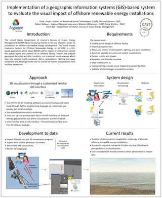
  • 1. Implementation of a geographic information systems (GIS)-based system to evaluate the visual impact of offshore renewable energy installations Chad Cooper – Center for Advanced Spatial Technologies (CAST), Jackson Cothren – CAST, Robert Sullivan – Argonne National Laboratory, Malcolm Williamson – CAST, Snow Winters – CAST, David Ball – Department of Interior, Bureau of Ocean Energy Management Introduction Requirements The United States Department of Interior's Bureau of Ocean Energy The system must: Management (BOEM) faces increasing interest in the use of waters under its · Enable spatial design of offshore facility jurisdiction for offshore renewable energy development. The Visual Impact · Import geospatial data Evaluation System for Offshore Renewable Energy, or VIESORE, is a GIS- · Allow user control of atmospheric, lighting, and wave conditions based application which allows BOEM staff to import or interactively design the spatial layout and content of an offshore facility, import and prepare · Generate spatially accurate and realistic visualizations geospatial data that will affect visibility, run a series of visual analyses which · Output reports and images take into account earth curvature, define atmospheric, lighting and wave · Provide a user-friendly interface conditions and, finally generate one or a series of realistic visualizations from It shall enable users to: multiple viewpoints. · Independently evaluate visual impact of proposed facilities · Validate photomontages provided by vendors Approach System design 3D visualizations through a customized familiar Inputs/user Visualization Outputs interaction processing GIS interface Renders Reports ArcGIS 10 IS ol rcG to A om s ArcGIS code 3D modeling st PDF Cu JPG · Vue Infinite 10 3D modeling software accessed in background batch mode through Python programming language via customized, yet familiar Esri ArcGIS interface HTML · Vue provides photorealistic renderings · User sets up real-world project data in ArcGIS interface, all data and AVI GIS data inputs settings get passed to Vue where visualizations are then created · Users familiar with ArcGIS interface – this eliminates need to learn Vue 3D software package Development to date Current results · Import GIS data into Vue 3D visualization program · Creation of photorealistic visualization renderings of planned All done in · Import wind turbine generator 3D models background via offshore renewable energy installations · Set camera and sun positions custom Python · Successful import of real-world GIS data into Vue 3D software code · Render to image (jpg) package for use in visualizations · User provided with friendly interface which allows them to import ArcGIS 10 data Planned installation Key observation point (KOP)