SlideShare a Scribd company logo
1 of 3
Download to read offline
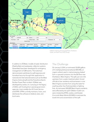
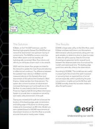
After a release of hazardous materials into a river or stream environment,
drinking water protection and contamination risk mitigation require that
information on the fate of waterborne contaminants be made available
quickly to decision makers. The Defense Threat Reduction Agency
(DTRA) has identified the Incident Command Tool for Drinking Water
Protection (ICWater) as a forecasting tool that can be used to predict the
consequences of a chemical, biological, or radiological (CBR) materials
release within river or stream systems.
ICWater was designed to answer four critical questions:
	 (1) Where is the contaminant going?
	 (2) Is there a drinking water intake in its path?
	 (3) When will it reach drinking water?
	 (4) Is its level high enough to be a human threat?
The tool interfaces with the US Geological Survey (USGS) real-time
stream gauging network. Contaminant travel time and concentration can
be estimated at locations downstream based on conditions at the time
of the spill. Several other relevant geographic databases are combined
within the tool to provide information that incident commanders require.
Information includes the location and contact information for all public
drinking water intakes, dams, hazardous material sites, pipelines, bridges,
and locations of critical infrastructure such as hospitals and fire and police
stations. ICWater also contains a reference database that identifies the
concentrations of CBR contaminants, which are a concern for human
health if consumed in drinking water. River networks have also been
developed for basins outside the contiguous United States, in Asia,
Africa, and Europe. Upstream tracing of the river network can be used
to identify sources of contaminants.
An Effective Tool for
Drinking Water Protection
Contact Information
William B. Samuels, PhD
Center for Water Science
and Engineering
Leidos, Inc.
703 253 8872
william.b.samuels@leidos.com
James C. Springer, PE
Greater Cincinnati
Water Works
513 624 5624
James.Springer@gcww
.cincinnati-oh.gov
Richard Fry
Defense Threat
Reduction Agency
703 767 3193
rick.fry@dtra.mil
In addition to ICWater, models of water distribution
(PipelineNet) and wastewater collection systems
(SewerNet) have been developed for emergency
management of CBR events. The tools have
demonstrated usefulness for spill response and
homeland security through their application in
national and international events such as the West
Virginia chemical spill and the Fukushima Daiichi
Nuclear Power Plant incident. ICWater was
developed by Leidos, Inc. (carrying on the legacy
of SAIC), with funding from several government
agencies, most notably the US Forest Service
and DTRA. DTRA currently maintains, trains, and
distributes the software to federal, state, and
local users.
The Challenge
On January 9, 2014, an estimated 10,000 gallons
of 4-methylcyclohexanemethanol (MCHM), an
organic solvent used in coal processing, leaked
from a ruptured container into the Elk River near
Charleston, West Virginia. The spill, just one mile
upstream from a water treatment plant, forced
officials to ban residents and businesses in nine
West Virginia counties from using the water for
anything other than flushing toilets or fighting
fires. An estimated 300,000 West Virginia residents
were affected by the spill. ICWater model runs
were initiated by DTRA, Leidos, and Greater
Cincinnati Water Works (GCWW) to estimate the
travel time and concentration of the spill.
ICWater Interface Showing Spill Site, Charleston
Intake, and Real-Time USGS Gauge
The Solution
ICWater, an Esri®
ArcGIS®
extension, uses the
National Hydrography Dataset Plus (NHDPlus) river
network for downstream and upstream tracing of
contaminants. The NHDPlus contains more than
three million stream and river reaches, all
hydrologically connected. Mean flow volume and
velocity are attributes of each reach in the network.
USGS real-time stream flow gauges are linked to
the network to update the mean flows and velocities
to reflect actual conditions. The difference between
the updated mean velocity in ICWater and the
measured velocity on the Kanawha River (just
downstream of the spill and the Charleston, West
Virginia, intake) was less than three percent. The
system also contains locations of industrial and
municipal dischargers such as the spill site on the
Elk River. It is also linked to the Environmental
Protection Agency Safe Drinking Water Information
System to provide data on populations served by
each water utility downstream of the spill.
Tracing was initiated at the spill site to forecast the
location of the leading edge, peak concentration,
and trailing edge of the plume for drinking water
intakes as far downstream as 200 miles. Model runs
were updated based on MCHM measurements at
downstream locations on the Ohio River to provide
accurate forecasts to nearby water intakes.
The Results
GCWW, a large water utility on the Ohio River, used
ICWater and National Oceanic and Atmospheric
Administration velocity estimations, along with river
grab samples, to determine when to close its intake
to allow the spill to pass by. Data for Cincinnati
showed good agreement (within several hours)
between the observed peak time of arrival and the
model’s estimated peak time. The leading-edge
predictions were also close to the observations.
According to GCWW, “The model was very useful
in preparing for the arrival of the spill. It assisted
in narrowing down an expected time of arrival
and was especially useful in predicting the peak
concentration. In spills such as the Elk River spill,
GCWW normally closes the raw water intakes to
allow the spill to pass.”
ICWater Downstream
Trace (120 hours travel
time) Showing Drinking
Water Intakes
Copyright © 2014 Esri. All rights reserved. Esri, the Esri globe logo, and ArcGIS, are trademarks, service marks, or registered marks
of Esri in the United States, the European Community, or certain other jurisdictions. Other companies and products or services
mentioned herein may be trademarks, service marks, or registered marks of their respective mark owners.
G63334
ESRI6/14ft

More Related Content

What's hot

EWCEWNRecommendationsJuly2014FINAL
EWCEWNRecommendationsJuly2014FINALEWCEWNRecommendationsJuly2014FINAL
EWCEWNRecommendationsJuly2014FINALPaul Faeth
 
Lanteigneredarlingtonnuclearplant 121015183235-phpapp01
Lanteigneredarlingtonnuclearplant 121015183235-phpapp01Lanteigneredarlingtonnuclearplant 121015183235-phpapp01
Lanteigneredarlingtonnuclearplant 121015183235-phpapp01Louisette Lanteigne
 
Abstract Shuvra
Abstract ShuvraAbstract Shuvra
Abstract Shuvra065msw418
 
Mathematical modeling approach for flood management
Mathematical modeling approach for flood managementMathematical modeling approach for flood management
Mathematical modeling approach for flood managementprjpublications
 
Lanteigne on Darlington Nuclear Plant
Lanteigne on Darlington Nuclear PlantLanteigne on Darlington Nuclear Plant
Lanteigne on Darlington Nuclear Plantlouisette lanteigne
 
Kaur,Mehar_GISPoster
Kaur,Mehar_GISPosterKaur,Mehar_GISPoster
Kaur,Mehar_GISPosterMehar Kaur
 
NHDES Rivers & Streams-NH
NHDES Rivers & Streams-NHNHDES Rivers & Streams-NH
NHDES Rivers & Streams-NHjoerando
 
T7 omar elbadawy flood risk assessment for non-gauged watersheds exec summary
T7 omar elbadawy   flood risk assessment for non-gauged watersheds exec summaryT7 omar elbadawy   flood risk assessment for non-gauged watersheds exec summary
T7 omar elbadawy flood risk assessment for non-gauged watersheds exec summaryNENAwaterscarcity
 
Bioassessment Approach to MS4 Evaluation and Assessment
Bioassessment Approach to MS4 Evaluation and AssessmentBioassessment Approach to MS4 Evaluation and Assessment
Bioassessment Approach to MS4 Evaluation and AssessmentJPoore
 
Afrirpa 2010 Assessing Natural And Anthropogenic Changes Of Radioactivity In ...
Afrirpa 2010 Assessing Natural And Anthropogenic Changes Of Radioactivity In ...Afrirpa 2010 Assessing Natural And Anthropogenic Changes Of Radioactivity In ...
Afrirpa 2010 Assessing Natural And Anthropogenic Changes Of Radioactivity In ...https://instagram.com/farideldaoushy
 
Flood forecasting presentation final
Flood forecasting presentation finalFlood forecasting presentation final
Flood forecasting presentation finalAbir Mohammad
 
Poster ciwem wfd catchment approach conference
Poster ciwem wfd catchment approach conferencePoster ciwem wfd catchment approach conference
Poster ciwem wfd catchment approach conferencecc04
 
Getting the Most From Weather Data - Daniel Pearson, Mark Lenz, Nelun Fernand...
Getting the Most From Weather Data - Daniel Pearson, Mark Lenz, Nelun Fernand...Getting the Most From Weather Data - Daniel Pearson, Mark Lenz, Nelun Fernand...
Getting the Most From Weather Data - Daniel Pearson, Mark Lenz, Nelun Fernand...TWCA
 
Study: The Potential Environmental Impacts of Fracking in the Delaware River ...
Study: The Potential Environmental Impacts of Fracking in the Delaware River ...Study: The Potential Environmental Impacts of Fracking in the Delaware River ...
Study: The Potential Environmental Impacts of Fracking in the Delaware River ...Marcellus Drilling News
 
Cozad, David, U.S. EPA Region 7, Compliance and Enforcment Update, at 2014 Mi...
Cozad, David, U.S. EPA Region 7, Compliance and Enforcment Update, at 2014 Mi...Cozad, David, U.S. EPA Region 7, Compliance and Enforcment Update, at 2014 Mi...
Cozad, David, U.S. EPA Region 7, Compliance and Enforcment Update, at 2014 Mi...Kevin Perry
 

What's hot (18)

Q4103103110
Q4103103110Q4103103110
Q4103103110
 
EWCEWNRecommendationsJuly2014FINAL
EWCEWNRecommendationsJuly2014FINALEWCEWNRecommendationsJuly2014FINAL
EWCEWNRecommendationsJuly2014FINAL
 
Lanteigneredarlingtonnuclearplant 121015183235-phpapp01
Lanteigneredarlingtonnuclearplant 121015183235-phpapp01Lanteigneredarlingtonnuclearplant 121015183235-phpapp01
Lanteigneredarlingtonnuclearplant 121015183235-phpapp01
 
Abstract Shuvra
Abstract ShuvraAbstract Shuvra
Abstract Shuvra
 
Mathematical modeling approach for flood management
Mathematical modeling approach for flood managementMathematical modeling approach for flood management
Mathematical modeling approach for flood management
 
Lanteigne on Darlington Nuclear Plant
Lanteigne on Darlington Nuclear PlantLanteigne on Darlington Nuclear Plant
Lanteigne on Darlington Nuclear Plant
 
X4201155161
X4201155161X4201155161
X4201155161
 
Kaur,Mehar_GISPoster
Kaur,Mehar_GISPosterKaur,Mehar_GISPoster
Kaur,Mehar_GISPoster
 
NHDES Rivers & Streams-NH
NHDES Rivers & Streams-NHNHDES Rivers & Streams-NH
NHDES Rivers & Streams-NH
 
T7 omar elbadawy flood risk assessment for non-gauged watersheds exec summary
T7 omar elbadawy   flood risk assessment for non-gauged watersheds exec summaryT7 omar elbadawy   flood risk assessment for non-gauged watersheds exec summary
T7 omar elbadawy flood risk assessment for non-gauged watersheds exec summary
 
Bioassessment Approach to MS4 Evaluation and Assessment
Bioassessment Approach to MS4 Evaluation and AssessmentBioassessment Approach to MS4 Evaluation and Assessment
Bioassessment Approach to MS4 Evaluation and Assessment
 
Afrirpa 2010 Assessing Natural And Anthropogenic Changes Of Radioactivity In ...
Afrirpa 2010 Assessing Natural And Anthropogenic Changes Of Radioactivity In ...Afrirpa 2010 Assessing Natural And Anthropogenic Changes Of Radioactivity In ...
Afrirpa 2010 Assessing Natural And Anthropogenic Changes Of Radioactivity In ...
 
Flood forecasting presentation final
Flood forecasting presentation finalFlood forecasting presentation final
Flood forecasting presentation final
 
2019 MATC Fall Webinar Series - Dr. Ricardo Mantilla
2019 MATC Fall Webinar Series - Dr. Ricardo Mantilla2019 MATC Fall Webinar Series - Dr. Ricardo Mantilla
2019 MATC Fall Webinar Series - Dr. Ricardo Mantilla
 
Poster ciwem wfd catchment approach conference
Poster ciwem wfd catchment approach conferencePoster ciwem wfd catchment approach conference
Poster ciwem wfd catchment approach conference
 
Getting the Most From Weather Data - Daniel Pearson, Mark Lenz, Nelun Fernand...
Getting the Most From Weather Data - Daniel Pearson, Mark Lenz, Nelun Fernand...Getting the Most From Weather Data - Daniel Pearson, Mark Lenz, Nelun Fernand...
Getting the Most From Weather Data - Daniel Pearson, Mark Lenz, Nelun Fernand...
 
Study: The Potential Environmental Impacts of Fracking in the Delaware River ...
Study: The Potential Environmental Impacts of Fracking in the Delaware River ...Study: The Potential Environmental Impacts of Fracking in the Delaware River ...
Study: The Potential Environmental Impacts of Fracking in the Delaware River ...
 
Cozad, David, U.S. EPA Region 7, Compliance and Enforcment Update, at 2014 Mi...
Cozad, David, U.S. EPA Region 7, Compliance and Enforcment Update, at 2014 Mi...Cozad, David, U.S. EPA Region 7, Compliance and Enforcment Update, at 2014 Mi...
Cozad, David, U.S. EPA Region 7, Compliance and Enforcment Update, at 2014 Mi...
 

Viewers also liked

Esri Location Analytics for Business Intelligence
Esri Location Analytics for Business IntelligenceEsri Location Analytics for Business Intelligence
Esri Location Analytics for Business IntelligenceEsri
 
GeoCollector for ArcPad
GeoCollector for ArcPadGeoCollector for ArcPad
GeoCollector for ArcPadEsri
 
Location Analytics for Marketing
Location Analytics for MarketingLocation Analytics for Marketing
Location Analytics for MarketingEsri
 
The Art and Science of Location Analytics
The Art and Science of Location AnalyticsThe Art and Science of Location Analytics
The Art and Science of Location AnalyticsCCIM Institute
 
GIS-Based Web Services Provide Rapid Analysis and Dissemination of Maritime Data
GIS-Based Web Services Provide Rapid Analysis and Dissemination of Maritime DataGIS-Based Web Services Provide Rapid Analysis and Dissemination of Maritime Data
GIS-Based Web Services Provide Rapid Analysis and Dissemination of Maritime DataEsri
 
GIS and Location-analytics-business
GIS and Location-analytics-businessGIS and Location-analytics-business
GIS and Location-analytics-businessEsri
 
5 Unexpected Ways To Use Location Analytics
5 Unexpected Ways To Use Location Analytics5 Unexpected Ways To Use Location Analytics
5 Unexpected Ways To Use Location AnalyticsQlikMaps
 

Viewers also liked (7)

Esri Location Analytics for Business Intelligence
Esri Location Analytics for Business IntelligenceEsri Location Analytics for Business Intelligence
Esri Location Analytics for Business Intelligence
 
GeoCollector for ArcPad
GeoCollector for ArcPadGeoCollector for ArcPad
GeoCollector for ArcPad
 
Location Analytics for Marketing
Location Analytics for MarketingLocation Analytics for Marketing
Location Analytics for Marketing
 
The Art and Science of Location Analytics
The Art and Science of Location AnalyticsThe Art and Science of Location Analytics
The Art and Science of Location Analytics
 
GIS-Based Web Services Provide Rapid Analysis and Dissemination of Maritime Data
GIS-Based Web Services Provide Rapid Analysis and Dissemination of Maritime DataGIS-Based Web Services Provide Rapid Analysis and Dissemination of Maritime Data
GIS-Based Web Services Provide Rapid Analysis and Dissemination of Maritime Data
 
GIS and Location-analytics-business
GIS and Location-analytics-businessGIS and Location-analytics-business
GIS and Location-analytics-business
 
5 Unexpected Ways To Use Location Analytics
5 Unexpected Ways To Use Location Analytics5 Unexpected Ways To Use Location Analytics
5 Unexpected Ways To Use Location Analytics
 

Similar to An Effective Tool for Drinking Water Protection

January 22 ESP 179 Hydro
January 22  ESP 179 HydroJanuary 22  ESP 179 Hydro
January 22 ESP 179 HydroCEQAplanner
 
Tide Prediction GIS Model for Willapa Bay
Tide Prediction GIS Model for Willapa BayTide Prediction GIS Model for Willapa Bay
Tide Prediction GIS Model for Willapa Bayfireflytza
 
Floodplain Modelling Materials and Methodology
Floodplain Modelling Materials and MethodologyFloodplain Modelling Materials and Methodology
Floodplain Modelling Materials and MethodologyIDES Editor
 
Cat Tales January/February 2015
Cat Tales January/February 2015Cat Tales January/February 2015
Cat Tales January/February 2015glennmcgillivray
 
Cat Tales January/February 2015
Cat Tales January/February 2015Cat Tales January/February 2015
Cat Tales January/February 2015glennmcgillivray
 
Improving statistical models for flood risk assessment
Improving statistical models for flood risk assessmentImproving statistical models for flood risk assessment
Improving statistical models for flood risk assessmentRoss Towe
 
The National Water Census
The National Water CensusThe National Water Census
The National Water CensusKim Beidler
 
The Effect Of Global Warming On Thermohaline Circulation
The Effect Of Global Warming On Thermohaline CirculationThe Effect Of Global Warming On Thermohaline Circulation
The Effect Of Global Warming On Thermohaline CirculationAmanda Hengel
 
Reducing Bacterial Contamination In Waterways
Reducing Bacterial Contamination In WaterwaysReducing Bacterial Contamination In Waterways
Reducing Bacterial Contamination In WaterwaysJason Schroeder
 
Hydrology final poster
Hydrology final posterHydrology final poster
Hydrology final posterAshtonGuest
 
Effectiveness of the telemetric flood monitoring device
Effectiveness of the telemetric flood monitoring deviceEffectiveness of the telemetric flood monitoring device
Effectiveness of the telemetric flood monitoring deviceHarhar Caparida
 
An analysis of mortality events of the West Indian manatee
An analysis of mortality events of the West Indian manateeAn analysis of mortality events of the West Indian manatee
An analysis of mortality events of the West Indian manateeKatherine Saalbach
 
Water quality modeling of an agricultural watershed with best management prac...
Water quality modeling of an agricultural watershed with best management prac...Water quality modeling of an agricultural watershed with best management prac...
Water quality modeling of an agricultural watershed with best management prac...eSAT Journals
 
Water quality modeling of an agricultural watershed with best management prac...
Water quality modeling of an agricultural watershed with best management prac...Water quality modeling of an agricultural watershed with best management prac...
Water quality modeling of an agricultural watershed with best management prac...eSAT Publishing House
 
2013 GISCO Track, Utilizing GIS to Locate Environmental and Recreation Stream...
2013 GISCO Track, Utilizing GIS to Locate Environmental and Recreation Stream...2013 GISCO Track, Utilizing GIS to Locate Environmental and Recreation Stream...
2013 GISCO Track, Utilizing GIS to Locate Environmental and Recreation Stream...GIS in the Rockies
 
Wi Lake Level Proposal Clmn
Wi Lake Level Proposal   ClmnWi Lake Level Proposal   Clmn
Wi Lake Level Proposal ClmnUWEX Lakes
 
2011_Sanstrom_ClallamCountyStreamkeepers_WaterResourceManagement
2011_Sanstrom_ClallamCountyStreamkeepers_WaterResourceManagement2011_Sanstrom_ClallamCountyStreamkeepers_WaterResourceManagement
2011_Sanstrom_ClallamCountyStreamkeepers_WaterResourceManagementValli Sanstrom
 
Hanson.GIS.DHS_FinalReport.Revised.04.20.2016 (1)
Hanson.GIS.DHS_FinalReport.Revised.04.20.2016 (1)Hanson.GIS.DHS_FinalReport.Revised.04.20.2016 (1)
Hanson.GIS.DHS_FinalReport.Revised.04.20.2016 (1)Angelina Hanson
 

Similar to An Effective Tool for Drinking Water Protection (20)

January 22 ESP 179 Hydro
January 22  ESP 179 HydroJanuary 22  ESP 179 Hydro
January 22 ESP 179 Hydro
 
Tide Prediction GIS Model for Willapa Bay
Tide Prediction GIS Model for Willapa BayTide Prediction GIS Model for Willapa Bay
Tide Prediction GIS Model for Willapa Bay
 
Floodplain Modelling Materials and Methodology
Floodplain Modelling Materials and MethodologyFloodplain Modelling Materials and Methodology
Floodplain Modelling Materials and Methodology
 
Cat Tales January/February 2015
Cat Tales January/February 2015Cat Tales January/February 2015
Cat Tales January/February 2015
 
Cat Tales January/February 2015
Cat Tales January/February 2015Cat Tales January/February 2015
Cat Tales January/February 2015
 
Improving statistical models for flood risk assessment
Improving statistical models for flood risk assessmentImproving statistical models for flood risk assessment
Improving statistical models for flood risk assessment
 
The National Water Census
The National Water CensusThe National Water Census
The National Water Census
 
The Effect Of Global Warming On Thermohaline Circulation
The Effect Of Global Warming On Thermohaline CirculationThe Effect Of Global Warming On Thermohaline Circulation
The Effect Of Global Warming On Thermohaline Circulation
 
Reducing Bacterial Contamination In Waterways
Reducing Bacterial Contamination In WaterwaysReducing Bacterial Contamination In Waterways
Reducing Bacterial Contamination In Waterways
 
Hydrology final poster
Hydrology final posterHydrology final poster
Hydrology final poster
 
Effectiveness of the telemetric flood monitoring device
Effectiveness of the telemetric flood monitoring deviceEffectiveness of the telemetric flood monitoring device
Effectiveness of the telemetric flood monitoring device
 
Lamichhane with signature
Lamichhane with signatureLamichhane with signature
Lamichhane with signature
 
An analysis of mortality events of the West Indian manatee
An analysis of mortality events of the West Indian manateeAn analysis of mortality events of the West Indian manatee
An analysis of mortality events of the West Indian manatee
 
Water quality modeling of an agricultural watershed with best management prac...
Water quality modeling of an agricultural watershed with best management prac...Water quality modeling of an agricultural watershed with best management prac...
Water quality modeling of an agricultural watershed with best management prac...
 
Water quality modeling of an agricultural watershed with best management prac...
Water quality modeling of an agricultural watershed with best management prac...Water quality modeling of an agricultural watershed with best management prac...
Water quality modeling of an agricultural watershed with best management prac...
 
Long form final
Long form finalLong form final
Long form final
 
2013 GISCO Track, Utilizing GIS to Locate Environmental and Recreation Stream...
2013 GISCO Track, Utilizing GIS to Locate Environmental and Recreation Stream...2013 GISCO Track, Utilizing GIS to Locate Environmental and Recreation Stream...
2013 GISCO Track, Utilizing GIS to Locate Environmental and Recreation Stream...
 
Wi Lake Level Proposal Clmn
Wi Lake Level Proposal   ClmnWi Lake Level Proposal   Clmn
Wi Lake Level Proposal Clmn
 
2011_Sanstrom_ClallamCountyStreamkeepers_WaterResourceManagement
2011_Sanstrom_ClallamCountyStreamkeepers_WaterResourceManagement2011_Sanstrom_ClallamCountyStreamkeepers_WaterResourceManagement
2011_Sanstrom_ClallamCountyStreamkeepers_WaterResourceManagement
 
Hanson.GIS.DHS_FinalReport.Revised.04.20.2016 (1)
Hanson.GIS.DHS_FinalReport.Revised.04.20.2016 (1)Hanson.GIS.DHS_FinalReport.Revised.04.20.2016 (1)
Hanson.GIS.DHS_FinalReport.Revised.04.20.2016 (1)
 

More from Esri

INIA- CISA: Análisis de las amenazas en la fauna silvestre
INIA- CISA: Análisis de las amenazas en la fauna silvestreINIA- CISA: Análisis de las amenazas en la fauna silvestre
INIA- CISA: Análisis de las amenazas en la fauna silvestreEsri
 
Aena Aeropuerto Adolfo Suárez-Barajas crea potentes aplicaciones para sus cli...
Aena Aeropuerto Adolfo Suárez-Barajas crea potentes aplicaciones para sus cli...Aena Aeropuerto Adolfo Suárez-Barajas crea potentes aplicaciones para sus cli...
Aena Aeropuerto Adolfo Suárez-Barajas crea potentes aplicaciones para sus cli...Esri
 
Plataforma Smart City de Móstoles
Plataforma Smart City de MóstolesPlataforma Smart City de Móstoles
Plataforma Smart City de MóstolesEsri
 
ArcGIS Online para Organizaciones
ArcGIS Online para OrganizacionesArcGIS Online para Organizaciones
ArcGIS Online para OrganizacionesEsri
 
Molina de Segura se convierte en una smart city
Molina de Segura se convierte en una smart cityMolina de Segura se convierte en una smart city
Molina de Segura se convierte en una smart cityEsri
 
Portal for ArcGIS
Portal for ArcGISPortal for ArcGIS
Portal for ArcGISEsri
 
GeoCollector for ArcGIS for Windows Mobile
GeoCollector for ArcGIS for Windows MobileGeoCollector for ArcGIS for Windows Mobile
GeoCollector for ArcGIS for Windows MobileEsri
 
Data Appliance for ArcGIS
Data Appliance for ArcGISData Appliance for ArcGIS
Data Appliance for ArcGISEsri
 
Esri and BlackBridge
Esri and BlackBridgeEsri and BlackBridge
Esri and BlackBridgeEsri
 
GeoPlanner for ArcGIS
GeoPlanner for ArcGISGeoPlanner for ArcGIS
GeoPlanner for ArcGISEsri
 
Esri and AccuWeather
Esri and AccuWeatherEsri and AccuWeather
Esri and AccuWeatherEsri
 
Esri and Airbus Defense & Space
Esri and Airbus Defense & SpaceEsri and Airbus Defense & Space
Esri and Airbus Defense & SpaceEsri
 
Esri US Data Fact Sheet
Esri US Data Fact SheetEsri US Data Fact Sheet
Esri US Data Fact SheetEsri
 
ArcGIS for Server on Microsoft Azure Jumpstart
ArcGIS for Server on Microsoft Azure JumpstartArcGIS for Server on Microsoft Azure Jumpstart
ArcGIS for Server on Microsoft Azure JumpstartEsri
 
ArcGIS for the Military--Maritime Operations
ArcGIS for the Military--Maritime OperationsArcGIS for the Military--Maritime Operations
ArcGIS for the Military--Maritime OperationsEsri
 
Esri Geoportal Server
Esri Geoportal ServerEsri Geoportal Server
Esri Geoportal ServerEsri
 
ArcGIS GeoEvent Extension for Server
ArcGIS GeoEvent Extension for ServerArcGIS GeoEvent Extension for Server
ArcGIS GeoEvent Extension for ServerEsri
 
The NATO Core Geographic Services System
The NATO Core Geographic Services SystemThe NATO Core Geographic Services System
The NATO Core Geographic Services SystemEsri
 
ArcGIS for Desktop Tips and Shortcuts
ArcGIS for Desktop Tips and ShortcutsArcGIS for Desktop Tips and Shortcuts
ArcGIS for Desktop Tips and ShortcutsEsri
 
ArcGIS Online
ArcGIS OnlineArcGIS Online
ArcGIS OnlineEsri
 

More from Esri (20)

INIA- CISA: Análisis de las amenazas en la fauna silvestre
INIA- CISA: Análisis de las amenazas en la fauna silvestreINIA- CISA: Análisis de las amenazas en la fauna silvestre
INIA- CISA: Análisis de las amenazas en la fauna silvestre
 
Aena Aeropuerto Adolfo Suárez-Barajas crea potentes aplicaciones para sus cli...
Aena Aeropuerto Adolfo Suárez-Barajas crea potentes aplicaciones para sus cli...Aena Aeropuerto Adolfo Suárez-Barajas crea potentes aplicaciones para sus cli...
Aena Aeropuerto Adolfo Suárez-Barajas crea potentes aplicaciones para sus cli...
 
Plataforma Smart City de Móstoles
Plataforma Smart City de MóstolesPlataforma Smart City de Móstoles
Plataforma Smart City de Móstoles
 
ArcGIS Online para Organizaciones
ArcGIS Online para OrganizacionesArcGIS Online para Organizaciones
ArcGIS Online para Organizaciones
 
Molina de Segura se convierte en una smart city
Molina de Segura se convierte en una smart cityMolina de Segura se convierte en una smart city
Molina de Segura se convierte en una smart city
 
Portal for ArcGIS
Portal for ArcGISPortal for ArcGIS
Portal for ArcGIS
 
GeoCollector for ArcGIS for Windows Mobile
GeoCollector for ArcGIS for Windows MobileGeoCollector for ArcGIS for Windows Mobile
GeoCollector for ArcGIS for Windows Mobile
 
Data Appliance for ArcGIS
Data Appliance for ArcGISData Appliance for ArcGIS
Data Appliance for ArcGIS
 
Esri and BlackBridge
Esri and BlackBridgeEsri and BlackBridge
Esri and BlackBridge
 
GeoPlanner for ArcGIS
GeoPlanner for ArcGISGeoPlanner for ArcGIS
GeoPlanner for ArcGIS
 
Esri and AccuWeather
Esri and AccuWeatherEsri and AccuWeather
Esri and AccuWeather
 
Esri and Airbus Defense & Space
Esri and Airbus Defense & SpaceEsri and Airbus Defense & Space
Esri and Airbus Defense & Space
 
Esri US Data Fact Sheet
Esri US Data Fact SheetEsri US Data Fact Sheet
Esri US Data Fact Sheet
 
ArcGIS for Server on Microsoft Azure Jumpstart
ArcGIS for Server on Microsoft Azure JumpstartArcGIS for Server on Microsoft Azure Jumpstart
ArcGIS for Server on Microsoft Azure Jumpstart
 
ArcGIS for the Military--Maritime Operations
ArcGIS for the Military--Maritime OperationsArcGIS for the Military--Maritime Operations
ArcGIS for the Military--Maritime Operations
 
Esri Geoportal Server
Esri Geoportal ServerEsri Geoportal Server
Esri Geoportal Server
 
ArcGIS GeoEvent Extension for Server
ArcGIS GeoEvent Extension for ServerArcGIS GeoEvent Extension for Server
ArcGIS GeoEvent Extension for Server
 
The NATO Core Geographic Services System
The NATO Core Geographic Services SystemThe NATO Core Geographic Services System
The NATO Core Geographic Services System
 
ArcGIS for Desktop Tips and Shortcuts
ArcGIS for Desktop Tips and ShortcutsArcGIS for Desktop Tips and Shortcuts
ArcGIS for Desktop Tips and Shortcuts
 
ArcGIS Online
ArcGIS OnlineArcGIS Online
ArcGIS Online
 

Recently uploaded

Kotlin Multiplatform & Compose Multiplatform - Starter kit for pragmatics
Kotlin Multiplatform & Compose Multiplatform - Starter kit for pragmaticsKotlin Multiplatform & Compose Multiplatform - Starter kit for pragmatics
Kotlin Multiplatform & Compose Multiplatform - Starter kit for pragmaticscarlostorres15106
 
#StandardsGoals for 2024: What’s new for BISAC - Tech Forum 2024
#StandardsGoals for 2024: What’s new for BISAC - Tech Forum 2024#StandardsGoals for 2024: What’s new for BISAC - Tech Forum 2024
#StandardsGoals for 2024: What’s new for BISAC - Tech Forum 2024BookNet Canada
 
Advanced Test Driven-Development @ php[tek] 2024
Advanced Test Driven-Development @ php[tek] 2024Advanced Test Driven-Development @ php[tek] 2024
Advanced Test Driven-Development @ php[tek] 2024Scott Keck-Warren
 
Human Factors of XR: Using Human Factors to Design XR Systems
Human Factors of XR: Using Human Factors to Design XR SystemsHuman Factors of XR: Using Human Factors to Design XR Systems
Human Factors of XR: Using Human Factors to Design XR SystemsMark Billinghurst
 
WhatsApp 9892124323 ✓Call Girls In Kalyan ( Mumbai ) secure service
WhatsApp 9892124323 ✓Call Girls In Kalyan ( Mumbai ) secure serviceWhatsApp 9892124323 ✓Call Girls In Kalyan ( Mumbai ) secure service
WhatsApp 9892124323 ✓Call Girls In Kalyan ( Mumbai ) secure servicePooja Nehwal
 
08448380779 Call Girls In Civil Lines Women Seeking Men
08448380779 Call Girls In Civil Lines Women Seeking Men08448380779 Call Girls In Civil Lines Women Seeking Men
08448380779 Call Girls In Civil Lines Women Seeking MenDelhi Call girls
 
Injustice - Developers Among Us (SciFiDevCon 2024)
Injustice - Developers Among Us (SciFiDevCon 2024)Injustice - Developers Among Us (SciFiDevCon 2024)
Injustice - Developers Among Us (SciFiDevCon 2024)Allon Mureinik
 
Pigging Solutions Piggable Sweeping Elbows
Pigging Solutions Piggable Sweeping ElbowsPigging Solutions Piggable Sweeping Elbows
Pigging Solutions Piggable Sweeping ElbowsPigging Solutions
 
The Codex of Business Writing Software for Real-World Solutions 2.pptx
The Codex of Business Writing Software for Real-World Solutions 2.pptxThe Codex of Business Writing Software for Real-World Solutions 2.pptx
The Codex of Business Writing Software for Real-World Solutions 2.pptxMalak Abu Hammad
 
SIEMENS: RAPUNZEL – A Tale About Knowledge Graph
SIEMENS: RAPUNZEL – A Tale About Knowledge GraphSIEMENS: RAPUNZEL – A Tale About Knowledge Graph
SIEMENS: RAPUNZEL – A Tale About Knowledge GraphNeo4j
 
Presentation on how to chat with PDF using ChatGPT code interpreter
Presentation on how to chat with PDF using ChatGPT code interpreterPresentation on how to chat with PDF using ChatGPT code interpreter
Presentation on how to chat with PDF using ChatGPT code interpreternaman860154
 
Artificial intelligence in the post-deep learning era
Artificial intelligence in the post-deep learning eraArtificial intelligence in the post-deep learning era
Artificial intelligence in the post-deep learning eraDeakin University
 
Benefits Of Flutter Compared To Other Frameworks
Benefits Of Flutter Compared To Other FrameworksBenefits Of Flutter Compared To Other Frameworks
Benefits Of Flutter Compared To Other FrameworksSoftradix Technologies
 
Tech-Forward - Achieving Business Readiness For Copilot in Microsoft 365
Tech-Forward - Achieving Business Readiness For Copilot in Microsoft 365Tech-Forward - Achieving Business Readiness For Copilot in Microsoft 365
Tech-Forward - Achieving Business Readiness For Copilot in Microsoft 3652toLead Limited
 
Key Features Of Token Development (1).pptx
Key  Features Of Token  Development (1).pptxKey  Features Of Token  Development (1).pptx
Key Features Of Token Development (1).pptxLBM Solutions
 
Beyond Boundaries: Leveraging No-Code Solutions for Industry Innovation
Beyond Boundaries: Leveraging No-Code Solutions for Industry InnovationBeyond Boundaries: Leveraging No-Code Solutions for Industry Innovation
Beyond Boundaries: Leveraging No-Code Solutions for Industry InnovationSafe Software
 
Automating Business Process via MuleSoft Composer | Bangalore MuleSoft Meetup...
Automating Business Process via MuleSoft Composer | Bangalore MuleSoft Meetup...Automating Business Process via MuleSoft Composer | Bangalore MuleSoft Meetup...
Automating Business Process via MuleSoft Composer | Bangalore MuleSoft Meetup...shyamraj55
 
Integration and Automation in Practice: CI/CD in Mule Integration and Automat...
Integration and Automation in Practice: CI/CD in Mule Integration and Automat...Integration and Automation in Practice: CI/CD in Mule Integration and Automat...
Integration and Automation in Practice: CI/CD in Mule Integration and Automat...Patryk Bandurski
 
Understanding the Laravel MVC Architecture
Understanding the Laravel MVC ArchitectureUnderstanding the Laravel MVC Architecture
Understanding the Laravel MVC ArchitecturePixlogix Infotech
 

Recently uploaded (20)

Kotlin Multiplatform & Compose Multiplatform - Starter kit for pragmatics
Kotlin Multiplatform & Compose Multiplatform - Starter kit for pragmaticsKotlin Multiplatform & Compose Multiplatform - Starter kit for pragmatics
Kotlin Multiplatform & Compose Multiplatform - Starter kit for pragmatics
 
#StandardsGoals for 2024: What’s new for BISAC - Tech Forum 2024
#StandardsGoals for 2024: What’s new for BISAC - Tech Forum 2024#StandardsGoals for 2024: What’s new for BISAC - Tech Forum 2024
#StandardsGoals for 2024: What’s new for BISAC - Tech Forum 2024
 
Advanced Test Driven-Development @ php[tek] 2024
Advanced Test Driven-Development @ php[tek] 2024Advanced Test Driven-Development @ php[tek] 2024
Advanced Test Driven-Development @ php[tek] 2024
 
Human Factors of XR: Using Human Factors to Design XR Systems
Human Factors of XR: Using Human Factors to Design XR SystemsHuman Factors of XR: Using Human Factors to Design XR Systems
Human Factors of XR: Using Human Factors to Design XR Systems
 
WhatsApp 9892124323 ✓Call Girls In Kalyan ( Mumbai ) secure service
WhatsApp 9892124323 ✓Call Girls In Kalyan ( Mumbai ) secure serviceWhatsApp 9892124323 ✓Call Girls In Kalyan ( Mumbai ) secure service
WhatsApp 9892124323 ✓Call Girls In Kalyan ( Mumbai ) secure service
 
08448380779 Call Girls In Civil Lines Women Seeking Men
08448380779 Call Girls In Civil Lines Women Seeking Men08448380779 Call Girls In Civil Lines Women Seeking Men
08448380779 Call Girls In Civil Lines Women Seeking Men
 
Injustice - Developers Among Us (SciFiDevCon 2024)
Injustice - Developers Among Us (SciFiDevCon 2024)Injustice - Developers Among Us (SciFiDevCon 2024)
Injustice - Developers Among Us (SciFiDevCon 2024)
 
Pigging Solutions Piggable Sweeping Elbows
Pigging Solutions Piggable Sweeping ElbowsPigging Solutions Piggable Sweeping Elbows
Pigging Solutions Piggable Sweeping Elbows
 
The Codex of Business Writing Software for Real-World Solutions 2.pptx
The Codex of Business Writing Software for Real-World Solutions 2.pptxThe Codex of Business Writing Software for Real-World Solutions 2.pptx
The Codex of Business Writing Software for Real-World Solutions 2.pptx
 
SIEMENS: RAPUNZEL – A Tale About Knowledge Graph
SIEMENS: RAPUNZEL – A Tale About Knowledge GraphSIEMENS: RAPUNZEL – A Tale About Knowledge Graph
SIEMENS: RAPUNZEL – A Tale About Knowledge Graph
 
Presentation on how to chat with PDF using ChatGPT code interpreter
Presentation on how to chat with PDF using ChatGPT code interpreterPresentation on how to chat with PDF using ChatGPT code interpreter
Presentation on how to chat with PDF using ChatGPT code interpreter
 
Artificial intelligence in the post-deep learning era
Artificial intelligence in the post-deep learning eraArtificial intelligence in the post-deep learning era
Artificial intelligence in the post-deep learning era
 
E-Vehicle_Hacking_by_Parul Sharma_null_owasp.pptx
E-Vehicle_Hacking_by_Parul Sharma_null_owasp.pptxE-Vehicle_Hacking_by_Parul Sharma_null_owasp.pptx
E-Vehicle_Hacking_by_Parul Sharma_null_owasp.pptx
 
Benefits Of Flutter Compared To Other Frameworks
Benefits Of Flutter Compared To Other FrameworksBenefits Of Flutter Compared To Other Frameworks
Benefits Of Flutter Compared To Other Frameworks
 
Tech-Forward - Achieving Business Readiness For Copilot in Microsoft 365
Tech-Forward - Achieving Business Readiness For Copilot in Microsoft 365Tech-Forward - Achieving Business Readiness For Copilot in Microsoft 365
Tech-Forward - Achieving Business Readiness For Copilot in Microsoft 365
 
Key Features Of Token Development (1).pptx
Key  Features Of Token  Development (1).pptxKey  Features Of Token  Development (1).pptx
Key Features Of Token Development (1).pptx
 
Beyond Boundaries: Leveraging No-Code Solutions for Industry Innovation
Beyond Boundaries: Leveraging No-Code Solutions for Industry InnovationBeyond Boundaries: Leveraging No-Code Solutions for Industry Innovation
Beyond Boundaries: Leveraging No-Code Solutions for Industry Innovation
 
Automating Business Process via MuleSoft Composer | Bangalore MuleSoft Meetup...
Automating Business Process via MuleSoft Composer | Bangalore MuleSoft Meetup...Automating Business Process via MuleSoft Composer | Bangalore MuleSoft Meetup...
Automating Business Process via MuleSoft Composer | Bangalore MuleSoft Meetup...
 
Integration and Automation in Practice: CI/CD in Mule Integration and Automat...
Integration and Automation in Practice: CI/CD in Mule Integration and Automat...Integration and Automation in Practice: CI/CD in Mule Integration and Automat...
Integration and Automation in Practice: CI/CD in Mule Integration and Automat...
 
Understanding the Laravel MVC Architecture
Understanding the Laravel MVC ArchitectureUnderstanding the Laravel MVC Architecture
Understanding the Laravel MVC Architecture
 

An Effective Tool for Drinking Water Protection

  • 1. After a release of hazardous materials into a river or stream environment, drinking water protection and contamination risk mitigation require that information on the fate of waterborne contaminants be made available quickly to decision makers. The Defense Threat Reduction Agency (DTRA) has identified the Incident Command Tool for Drinking Water Protection (ICWater) as a forecasting tool that can be used to predict the consequences of a chemical, biological, or radiological (CBR) materials release within river or stream systems. ICWater was designed to answer four critical questions: (1) Where is the contaminant going? (2) Is there a drinking water intake in its path? (3) When will it reach drinking water? (4) Is its level high enough to be a human threat? The tool interfaces with the US Geological Survey (USGS) real-time stream gauging network. Contaminant travel time and concentration can be estimated at locations downstream based on conditions at the time of the spill. Several other relevant geographic databases are combined within the tool to provide information that incident commanders require. Information includes the location and contact information for all public drinking water intakes, dams, hazardous material sites, pipelines, bridges, and locations of critical infrastructure such as hospitals and fire and police stations. ICWater also contains a reference database that identifies the concentrations of CBR contaminants, which are a concern for human health if consumed in drinking water. River networks have also been developed for basins outside the contiguous United States, in Asia, Africa, and Europe. Upstream tracing of the river network can be used to identify sources of contaminants. An Effective Tool for Drinking Water Protection Contact Information William B. Samuels, PhD Center for Water Science and Engineering Leidos, Inc. 703 253 8872 william.b.samuels@leidos.com James C. Springer, PE Greater Cincinnati Water Works 513 624 5624 James.Springer@gcww .cincinnati-oh.gov Richard Fry Defense Threat Reduction Agency 703 767 3193 rick.fry@dtra.mil
  • 2. In addition to ICWater, models of water distribution (PipelineNet) and wastewater collection systems (SewerNet) have been developed for emergency management of CBR events. The tools have demonstrated usefulness for spill response and homeland security through their application in national and international events such as the West Virginia chemical spill and the Fukushima Daiichi Nuclear Power Plant incident. ICWater was developed by Leidos, Inc. (carrying on the legacy of SAIC), with funding from several government agencies, most notably the US Forest Service and DTRA. DTRA currently maintains, trains, and distributes the software to federal, state, and local users. The Challenge On January 9, 2014, an estimated 10,000 gallons of 4-methylcyclohexanemethanol (MCHM), an organic solvent used in coal processing, leaked from a ruptured container into the Elk River near Charleston, West Virginia. The spill, just one mile upstream from a water treatment plant, forced officials to ban residents and businesses in nine West Virginia counties from using the water for anything other than flushing toilets or fighting fires. An estimated 300,000 West Virginia residents were affected by the spill. ICWater model runs were initiated by DTRA, Leidos, and Greater Cincinnati Water Works (GCWW) to estimate the travel time and concentration of the spill. ICWater Interface Showing Spill Site, Charleston Intake, and Real-Time USGS Gauge
  • 3. The Solution ICWater, an Esri® ArcGIS® extension, uses the National Hydrography Dataset Plus (NHDPlus) river network for downstream and upstream tracing of contaminants. The NHDPlus contains more than three million stream and river reaches, all hydrologically connected. Mean flow volume and velocity are attributes of each reach in the network. USGS real-time stream flow gauges are linked to the network to update the mean flows and velocities to reflect actual conditions. The difference between the updated mean velocity in ICWater and the measured velocity on the Kanawha River (just downstream of the spill and the Charleston, West Virginia, intake) was less than three percent. The system also contains locations of industrial and municipal dischargers such as the spill site on the Elk River. It is also linked to the Environmental Protection Agency Safe Drinking Water Information System to provide data on populations served by each water utility downstream of the spill. Tracing was initiated at the spill site to forecast the location of the leading edge, peak concentration, and trailing edge of the plume for drinking water intakes as far downstream as 200 miles. Model runs were updated based on MCHM measurements at downstream locations on the Ohio River to provide accurate forecasts to nearby water intakes. The Results GCWW, a large water utility on the Ohio River, used ICWater and National Oceanic and Atmospheric Administration velocity estimations, along with river grab samples, to determine when to close its intake to allow the spill to pass by. Data for Cincinnati showed good agreement (within several hours) between the observed peak time of arrival and the model’s estimated peak time. The leading-edge predictions were also close to the observations. According to GCWW, “The model was very useful in preparing for the arrival of the spill. It assisted in narrowing down an expected time of arrival and was especially useful in predicting the peak concentration. In spills such as the Elk River spill, GCWW normally closes the raw water intakes to allow the spill to pass.” ICWater Downstream Trace (120 hours travel time) Showing Drinking Water Intakes Copyright © 2014 Esri. All rights reserved. Esri, the Esri globe logo, and ArcGIS, are trademarks, service marks, or registered marks of Esri in the United States, the European Community, or certain other jurisdictions. Other companies and products or services mentioned herein may be trademarks, service marks, or registered marks of their respective mark owners. G63334 ESRI6/14ft