Downloaded 367 times


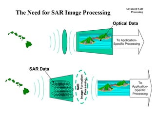
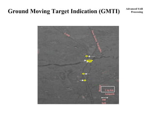
![Advanced SAR
Processing
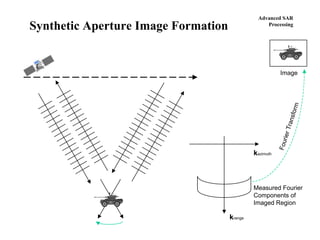
Seismic Migration Algorithm
in four elegant steps
Step 1: Fourier transform the range compressed[1] phase history data
Step 2: Interpolate the transformed phase history
This is the so-called “Stolt interpolation,” which effectively corrects for range curvature.
Step 3
Multiply the interpolated, transformed phase history by a phase factor
This is effectively the azimuth matched-filter.
Step 4
Inverse transform the Fourier transform of the image
which produces the complex image.
Fine Points
Range compression may conveniently be done by multiplying D(κ,ω) by the complex conjugate of the range reference function[2] in Step 1.
Windows, spectral filters, equalization factors, etc., may be multiplied onto I(kx,ky) or D(κ,ω) anywhere between the Fourier transforms in Steps 1
and 4. This enables custom shaping of the impulse response, compensation of antenna patterns, transmit pulse equalization, etc.
[1] “Range compressed” phase history data because we don’t want to mix in any phase modulation included with the transmit pulse, e.g., the
quadratic phase of a chirped pulse.
[2] The range reference function is the Fourier transform of the transmitted pulse.
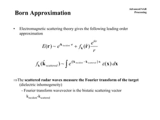
{ } ξττξκξωτπωκ dddiD ∫∫ +−= ),()(2exp),(
⎟⎟
⎟
⎠
⎞
⎜⎜
⎜
⎝
⎛
⎥
⎥
⎦
⎤
⎢
⎢
⎣
⎡
−+⎟
⎠
⎞
⎜
⎝
⎛
+=⎟
⎠
⎞
⎜
⎝
⎛
λλ
22
2
,
2
,' 2
2
xyxyx kk
c
kDk
c
kD
⎟
⎠
⎞
⎜
⎝
⎛
⎪⎭
⎪
⎬
⎫
⎪⎩
⎪
⎨
⎧
⎥
⎥
⎦
⎤
⎢
⎢
⎣
⎡
−
λ
−+⎟
⎠
⎞
⎜
⎝
⎛
+
λ
π−= yxy
2
x
2
y0yx k
2
c
,k'Dk
2
kk
2
iR2exp)k,k(I
{ } yxyxyx dkdkkkIykxkiyxi ∫∫ ++= ),()(2exp),( π](https://image.slidesharecdn.com/syntheticapertureradaradvanced-130924232553-phpapp02/85/Synthetic-aperture-radar_advanced-13-320.jpg)


This document provides information about an upcoming training course on advanced synthetic aperture radar (SAR) processing being offered by the Applied Technology Institute (ATI). The 2-day course will be held on May 6-7, 2009 in Chantilly, Virginia and will be instructed by Bart Huxtable. It will cover topics such as SAR review origins, basic and advanced SAR processing techniques, interferometric SAR, spotlight mode SAR, and polarimetric SAR. The course outline and schedule are provided along with instructor biographies and registration information. Additionally, the document advertises ATI's ability to provide on-site customized training courses.


