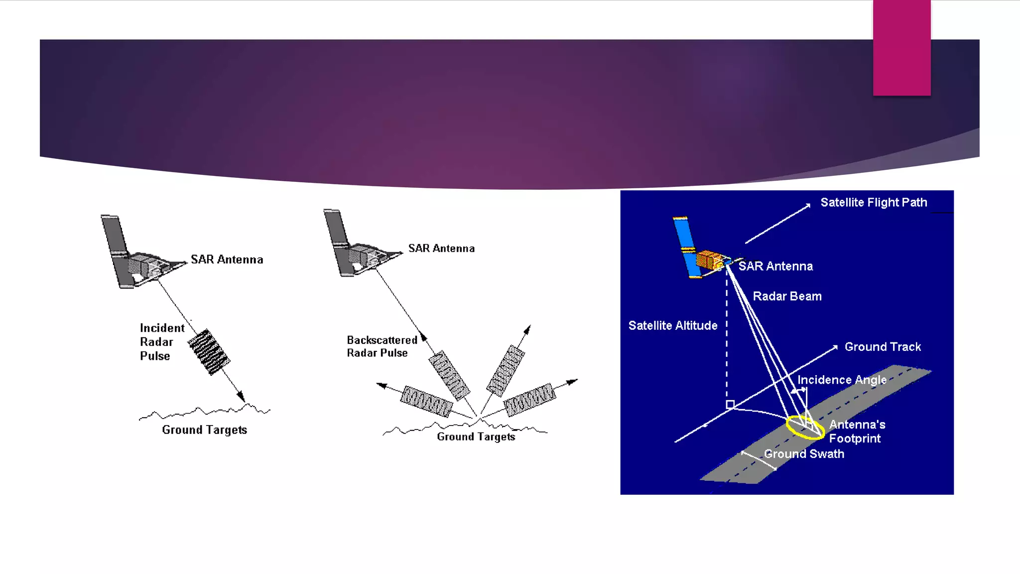
SYNTHETIC APERTURE RADAR
PRESENTED BY : CIGI CLETUS
CONTENTS
 INTRODUCTION
 GENERAL DESCRIPTION
 WORKING OF SAR
 APPLICATION
 ADVANTAGES
 FUTURE SCOPE
 CONCLUSION
 REFERENCES
INTRODUCTION
 Synthetic aperture radar (SAR) is a coherent active microwave imaging method. used to create two-
dimensional images or three-dimensional reconstructions of objects, such as landscapes.
 Interferometric SAR (InSAR) derived information data sets can be used to measure several geophysical
quantities, such as topography, deformations (volcanoes, earthquakes, ice fields), glacier flows, ocean
currents, vegetation properties, etc.
 SAR uses the motion of the radar antenna over a target region to provide finer spatial resolution than
conventional beam-scanning radars. SAR is typically mounted on a moving platform, such as an aircraft or
spacecraft, and has its origins in an advanced form of side looking airborne radar (SLAR).
SYNTHETIC APERTURE RADAR
 A microwave radiometer is a passive device which records the natural microwave emission
from the earth
 A radar altimeter sends out pulses of microwave signals and record the signal scattered
back from the earth surface
 A wind scatterometer can be used to measure wind speed and direction over the ocean
surface. it sends out pulses of microwaves along several directions and records the
magnitude of the signals backscattered from the ocean surface.
TYPES OF BANDS IN SAR
 Wavelengths of SAR are partitioned as optical and microwave regions , depending on
the electromagnetic spectrum
BANDS IN SAR
 S-band vs other bands
The NovaSAR-1 payload uses the S-band frequency range, which is less common in
spaceborne SAR systems than the X-, C- and L-bands, but is growing due to advances
in electronics.
ADVANTAGES OF BAND
Advantages of S-band
 Performs significantly better in adverse weather conditions such as high rainfall
than X-band, slightly more so than C-band, so can be more useful in active
meteorological disaster areas.
 Better ground penetration than higher frequency C and X bands
 potentially useful for detection of variations in soil moisture and detection of sub-
surface features.
 Shows discrimination between different vegetation structural types, due to greater
penetration through the upper canopy layers, making it effective for vegetation
monitoring, land cover classification, and forestry analysis.
APPLICATIONS
 Monitoring of Environment and Resources
 Surveying
 Three Dimension (3D) data of Surface
 Ground Penetration
 Moving Object Information
 Navigation
 Change Detection
SOFTWARES USED
 ArcGIS 10 and ERDAS IMAGINE 2013 were used to process the Digital Elevation
Models. MATLAB and R software environments were used to implement the
simulation algorithm.
 Python language was used for the extraction of information from metadata of
satellite images. Multisim simulation software was used to simulate the power
supply and modulator circuits of the radar system.
DATA COLLECTION
 Digital Elevation Models (DEMs) :
 ASTER (Advanced Spaceborne Thermal Emission and Reflection Radiometer) DEM of
spatial resolution 1 arc-second (30 m) and SRTM (Shuttle Radar Topography Mission)
DEM of spatial resolution 3 arc-seconds (90 m) have been used in the project. Aster
DEM (Japan Aerospace Exploration Agency 2009)has been downloaded from
downloaded from http://gdem.ersdac.jspacesystems.or.jp/. SRTM DEM has been
downloaded from http://earthexplorer.usgs.gov/.
 Satellite data :
 The data of RADARSAT-2 and ALOS PALSAR have been used to validate simulation
results. Launched on 14 December 2007, RADARSAT-2 works in the C-band with a
centre frequency of 5.4GHz, and has quad-polarization capability. It has a very high
Synthetic Aperture Radar (SAR) Data Simulation for Radar Backscatter Cross-section
Retrieval 14 resolution of 1m in the range direction and 3m in the azimuth direction in
the spotlight mode. The orbit of RADARSAT-2 has an altitude of 798km and an
inclination of 98.600 .
ADVANTAGES
 SAR concept showing small ground coverages and small imaging angles,
increasing the resolution of the imagery.
 Traditional large aperture RADAR showing a large ground coverage and large
imaging angles, resulting in lower resolution imagery
 SAR techniques in RISAT-1 satellite will open the new gate way of research,
educations, business, spatial planning as far as agricultural monitoring, military
strategy, and disaster management.
FUTURE SCOPE
 Continued development of SAR RGBs for qualitative analysis for decision makers
as well as supplemental training for interpretation.
 Work with end users on how quantitative products can be best integrated into
their analysis and response activities, including training with end users so that
they can draw the correct inference from the imagery products.
 Expanding the use of SAR products presented in this research to also cover DSS
support of wildfires, as both optical remote sensing and SAR analysis provide
numerous opportunities for mapping wildfires.
 Focus on objective algorithms for automatic extraction of affected region
CONCLUSION
Extending the range of a SAR system can be done by incorporating any of the following:
 Increasing average TX power (peak TX power and/or duty factor)
 Increasing antenna area and/or efficiency of operating in a more optimal radar band
(or portion of a radar band)
 Flying at a more optimal altitude (usually higher)
 Operating with coarser range resolution (azimuth resolution doesn’t help)
 Decreasing tangential velocity (decreasing velocity, or more severe squint angles)
 Decreasing system losses and/or system noise factor operating in more benign
weather conditions degrading the noise equivalent reflectivity required of the scene
REFERENCES
 Synthetic Aperture Radar in Indian Remote Sensing Sainath P. Aher Dept. of
Geography, Sangamner College, Sangamner, Dist. A.Nagar, Maharashtra Shivaji
B. Khemnar, Ph. D Dept. of Geography, Agasti Arts, Comm. & D.R. Sci. College
Akole, Dist: A.Nagar, Maharashtra Shambhaji D. Shinde, Ph.D Dept. of
Geography, Shivaji University, Kolhapur, Maharashtra
 Synthetic-aperture radarFrom Wikipedia, the free encyclopedia
 Advantages and Applications of Synthetic Aperture Radar as a Decision Support
Tool Andrew L. Molthan 1 , Jordan R. Bell 2 , Lori A. Schultz 2
 Performance Limits for Synthetic Aperture Radar Armin W. Doerry
 Synthetic Aperture Radar (SAR) Data Simulation for Radar Backscatter Cross-
section Retrieval, Kimeera Tummala
THANK YOU

Synthetic aperture radar

  • 1.
  • 2.
    CONTENTS  INTRODUCTION  GENERALDESCRIPTION  WORKING OF SAR  APPLICATION  ADVANTAGES  FUTURE SCOPE  CONCLUSION  REFERENCES
  • 3.
    INTRODUCTION  Synthetic apertureradar (SAR) is a coherent active microwave imaging method. used to create two- dimensional images or three-dimensional reconstructions of objects, such as landscapes.  Interferometric SAR (InSAR) derived information data sets can be used to measure several geophysical quantities, such as topography, deformations (volcanoes, earthquakes, ice fields), glacier flows, ocean currents, vegetation properties, etc.  SAR uses the motion of the radar antenna over a target region to provide finer spatial resolution than conventional beam-scanning radars. SAR is typically mounted on a moving platform, such as an aircraft or spacecraft, and has its origins in an advanced form of side looking airborne radar (SLAR).
  • 4.
    SYNTHETIC APERTURE RADAR A microwave radiometer is a passive device which records the natural microwave emission from the earth  A radar altimeter sends out pulses of microwave signals and record the signal scattered back from the earth surface  A wind scatterometer can be used to measure wind speed and direction over the ocean surface. it sends out pulses of microwaves along several directions and records the magnitude of the signals backscattered from the ocean surface.
  • 6.
    TYPES OF BANDSIN SAR  Wavelengths of SAR are partitioned as optical and microwave regions , depending on the electromagnetic spectrum
  • 7.
    BANDS IN SAR S-band vs other bands The NovaSAR-1 payload uses the S-band frequency range, which is less common in spaceborne SAR systems than the X-, C- and L-bands, but is growing due to advances in electronics.
  • 8.
    ADVANTAGES OF BAND Advantagesof S-band  Performs significantly better in adverse weather conditions such as high rainfall than X-band, slightly more so than C-band, so can be more useful in active meteorological disaster areas.  Better ground penetration than higher frequency C and X bands  potentially useful for detection of variations in soil moisture and detection of sub- surface features.  Shows discrimination between different vegetation structural types, due to greater penetration through the upper canopy layers, making it effective for vegetation monitoring, land cover classification, and forestry analysis.
  • 9.
    APPLICATIONS  Monitoring ofEnvironment and Resources  Surveying  Three Dimension (3D) data of Surface  Ground Penetration  Moving Object Information  Navigation  Change Detection
  • 10.
    SOFTWARES USED  ArcGIS10 and ERDAS IMAGINE 2013 were used to process the Digital Elevation Models. MATLAB and R software environments were used to implement the simulation algorithm.  Python language was used for the extraction of information from metadata of satellite images. Multisim simulation software was used to simulate the power supply and modulator circuits of the radar system.
  • 11.
    DATA COLLECTION  DigitalElevation Models (DEMs) :  ASTER (Advanced Spaceborne Thermal Emission and Reflection Radiometer) DEM of spatial resolution 1 arc-second (30 m) and SRTM (Shuttle Radar Topography Mission) DEM of spatial resolution 3 arc-seconds (90 m) have been used in the project. Aster DEM (Japan Aerospace Exploration Agency 2009)has been downloaded from downloaded from http://gdem.ersdac.jspacesystems.or.jp/. SRTM DEM has been downloaded from http://earthexplorer.usgs.gov/.  Satellite data :  The data of RADARSAT-2 and ALOS PALSAR have been used to validate simulation results. Launched on 14 December 2007, RADARSAT-2 works in the C-band with a centre frequency of 5.4GHz, and has quad-polarization capability. It has a very high Synthetic Aperture Radar (SAR) Data Simulation for Radar Backscatter Cross-section Retrieval 14 resolution of 1m in the range direction and 3m in the azimuth direction in the spotlight mode. The orbit of RADARSAT-2 has an altitude of 798km and an inclination of 98.600 .
  • 12.
    ADVANTAGES  SAR conceptshowing small ground coverages and small imaging angles, increasing the resolution of the imagery.  Traditional large aperture RADAR showing a large ground coverage and large imaging angles, resulting in lower resolution imagery  SAR techniques in RISAT-1 satellite will open the new gate way of research, educations, business, spatial planning as far as agricultural monitoring, military strategy, and disaster management.
  • 13.
    FUTURE SCOPE  Continueddevelopment of SAR RGBs for qualitative analysis for decision makers as well as supplemental training for interpretation.  Work with end users on how quantitative products can be best integrated into their analysis and response activities, including training with end users so that they can draw the correct inference from the imagery products.  Expanding the use of SAR products presented in this research to also cover DSS support of wildfires, as both optical remote sensing and SAR analysis provide numerous opportunities for mapping wildfires.  Focus on objective algorithms for automatic extraction of affected region
  • 14.
    CONCLUSION Extending the rangeof a SAR system can be done by incorporating any of the following:  Increasing average TX power (peak TX power and/or duty factor)  Increasing antenna area and/or efficiency of operating in a more optimal radar band (or portion of a radar band)  Flying at a more optimal altitude (usually higher)  Operating with coarser range resolution (azimuth resolution doesn’t help)  Decreasing tangential velocity (decreasing velocity, or more severe squint angles)  Decreasing system losses and/or system noise factor operating in more benign weather conditions degrading the noise equivalent reflectivity required of the scene
  • 15.
    REFERENCES  Synthetic ApertureRadar in Indian Remote Sensing Sainath P. Aher Dept. of Geography, Sangamner College, Sangamner, Dist. A.Nagar, Maharashtra Shivaji B. Khemnar, Ph. D Dept. of Geography, Agasti Arts, Comm. & D.R. Sci. College Akole, Dist: A.Nagar, Maharashtra Shambhaji D. Shinde, Ph.D Dept. of Geography, Shivaji University, Kolhapur, Maharashtra  Synthetic-aperture radarFrom Wikipedia, the free encyclopedia  Advantages and Applications of Synthetic Aperture Radar as a Decision Support Tool Andrew L. Molthan 1 , Jordan R. Bell 2 , Lori A. Schultz 2  Performance Limits for Synthetic Aperture Radar Armin W. Doerry  Synthetic Aperture Radar (SAR) Data Simulation for Radar Backscatter Cross- section Retrieval, Kimeera Tummala
  • 16.