Download to read offline

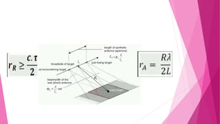


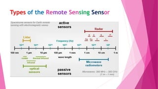

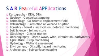


Synthetic Aperture Radar (SAR) is an active imaging radar system that uses the motion of the radar antenna over an area to synthesize a large antenna aperture, allowing for high-resolution remote sensing images. SAR transmits radar pulses and receives the backscattered signals to generate images. The forward motion of the radar platform is used to synthesize a large antenna, providing high azimuth resolution despite using a small physical antenna. SAR operates by transmitting pulses at each position along the flight path and recording the returning echoes to build up an image. Range and azimuth resolution are determined by pulse bandwidth and antenna length respectively. SAR has many applications including cartography, geology, forestry, and environmental monitoring.