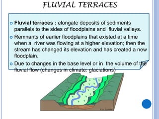
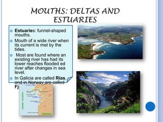
RIVER LANDFORMS

            Xon Vilahur i Godoy
           Institut de Llagostera
RIVER-BASIN

   A river basin is an area drained by a river
    and its tributaries. Other river features
    include:
   Watershed, an area of higher land
    separating two drainage basins.
   Source, the place where a river begin
   Tributary, a smaller river joining a large
    river
   Confluence, the place where two rivers
    join.
   Mouth, the place where a river enters in a
    lake or the sea
   Streams or brooks are the names given to
    small rivers
   Drainage pattern is the way rivers are
    arranged on the landscape, the most
    commons ar, dendritic, parallel or radial.
UPPER COURSE:
                   WATERFALLS AND RAPIDS

   A waterfall is a place on a river where water flows vertically. Waterfalls are
    a common feature in the upper course of many large rivers. A waterfall
    occurs when a layer of hard resistant rock lies over a layer of softer rock,
    which will erode more easily.
Rapids are a series of little waterfalls; these can be found where a waterfall
 has retreated, the hard rock layer is undercut causing the waterfall to move
 upstream. They are found where there are alternative bands of hard and
 soft rocks.
MIDDLE COURSE:
FLOODPLAIN, MEANDERS AND OX-BOW LAKES

    Less steep gradient, lateral erosion,
     the river starts to meander.
     Over time, the loop of a meander
     becomes tighter: the river cut
     across the neck of the meander to
     form a straight river channel and
     forms an ox-bow lake.
 o   Floodplains: area of flat land
     formed on either side of a river,
     combination of erosion and
     deposition :
    Deposits of alluvium (                  "http://www.libraryindex.com/pages/8308/meander.html">meander</a>


    Fertile and good for farming and
     agriculture.
    Floodplains are highly populated.

 http://www.youtube.com/watch?v=8uV-
    BuBpIFw&feature=related
FLUVIAL TERRACES

 Fluvial terraces : elongate deposits of sediments
  parallels to the sides of floodplains and fluvial valleys.
 Remnants of earlier floodplains that existed at a time
  when a river was flowing at a higher elevation; then the
  stream has changed its elevation and has created a new
  floodplain.
 Due to changes in the base level or in the volume of the
  fluvial flow (changes in climate: glaciations)
MOUTHS: DELTAS AND ESTUARIES
 River channel deep and wide,
  large discharge
 Valley, wide and flat, wide flood
  plain.
 Deltas , deposits of alluvium,
  sand, silt and clay at the mouth
  of large rivers (Ganges, Nile,
  Ebre,…) in tideless seas.
 The deposit of the river load
  occurs faster than the sea can
  remove the material.
                                      ADJECTIVES:
 Permanent land feature, rich in      Large/ narrow

  alluvium, fertile farmland.          long/short
                                       small/big
                                       deep/shallow
                                       wide/narrow
                                       fertile/sterile
                                       good/bad
MOUTHS: DELTAS AND
               ESTUARIES
   Estuaries: funnel-shaped
    mouths.
   Mouth of a wide river when
    its current is met by the
    tides.
    Most are found where an
    existing river has had its
    lower reaches flooded ed
    river after changes in sea
    level.
   In Galicia are called Rías,
    and in Norway are called
    Fjords
FLOODINGS

   Flood : river that overflows its banks
   Causes: A rapid increase in discharge over a short period of time,
    so the river system is unable to transport it away.
   Factors: Both human and physical factors
   Physical factors: prolonged rain or a short heavy rain storm, snow
    melt which releases stored water; steep slopes, narrow valleys or
    impermeable rocks.
   Human factors: Deforestation, construction of urban areas,
    changes of the natural course of the river.
FLOODINGS
   Impacts: devastation, extensive
    damage, destruction of food supplies,
    buildings, farmlands, vehicles,
    transports, power and people.
   Worse impact on LEDCs than on
    MEDCs. (emergency services,
    money, equipments, and poor
    communications in LEDCs make
    recovery more difficult.)
   Benefits, deposits fine silt and
    sediment, which helps to fertilise the
    soil and generates excellent conditions
    for farming.
    Some LEDCs use river flooding to
    cover farmland with fertile alluvium and
    also to provide water for irrigation
    channels (e.g. Ganges in Bangladesh)
   Prevention: prediction, prevention
    and control.
    Flood management to reduce the
    impact of flooding: river management,
    changing land use, dams and
    reservoirs...

River landforms

  • 1.
    RIVER LANDFORMS Xon Vilahur i Godoy Institut de Llagostera
  • 2.
    RIVER-BASIN  A river basin is an area drained by a river and its tributaries. Other river features include:  Watershed, an area of higher land separating two drainage basins.  Source, the place where a river begin  Tributary, a smaller river joining a large river  Confluence, the place where two rivers join.  Mouth, the place where a river enters in a lake or the sea  Streams or brooks are the names given to small rivers  Drainage pattern is the way rivers are arranged on the landscape, the most commons ar, dendritic, parallel or radial.
  • 3.
    UPPER COURSE: WATERFALLS AND RAPIDS  A waterfall is a place on a river where water flows vertically. Waterfalls are a common feature in the upper course of many large rivers. A waterfall occurs when a layer of hard resistant rock lies over a layer of softer rock, which will erode more easily. Rapids are a series of little waterfalls; these can be found where a waterfall has retreated, the hard rock layer is undercut causing the waterfall to move upstream. They are found where there are alternative bands of hard and soft rocks.
  • 4.
    MIDDLE COURSE: FLOODPLAIN, MEANDERSAND OX-BOW LAKES  Less steep gradient, lateral erosion, the river starts to meander.  Over time, the loop of a meander becomes tighter: the river cut across the neck of the meander to form a straight river channel and forms an ox-bow lake. o Floodplains: area of flat land formed on either side of a river, combination of erosion and deposition :  Deposits of alluvium ( "http://www.libraryindex.com/pages/8308/meander.html">meander</a>  Fertile and good for farming and agriculture.  Floodplains are highly populated. http://www.youtube.com/watch?v=8uV- BuBpIFw&feature=related
  • 5.
    FLUVIAL TERRACES  Fluvialterraces : elongate deposits of sediments parallels to the sides of floodplains and fluvial valleys.  Remnants of earlier floodplains that existed at a time when a river was flowing at a higher elevation; then the stream has changed its elevation and has created a new floodplain.  Due to changes in the base level or in the volume of the fluvial flow (changes in climate: glaciations)
  • 6.
    MOUTHS: DELTAS ANDESTUARIES  River channel deep and wide, large discharge  Valley, wide and flat, wide flood plain.  Deltas , deposits of alluvium, sand, silt and clay at the mouth of large rivers (Ganges, Nile, Ebre,…) in tideless seas.  The deposit of the river load occurs faster than the sea can remove the material. ADJECTIVES:  Permanent land feature, rich in  Large/ narrow alluvium, fertile farmland.  long/short  small/big  deep/shallow  wide/narrow  fertile/sterile  good/bad
  • 7.
    MOUTHS: DELTAS AND ESTUARIES  Estuaries: funnel-shaped mouths.  Mouth of a wide river when its current is met by the tides.  Most are found where an existing river has had its lower reaches flooded ed river after changes in sea level.  In Galicia are called Rías, and in Norway are called Fjords
  • 8.
    FLOODINGS  Flood : river that overflows its banks  Causes: A rapid increase in discharge over a short period of time, so the river system is unable to transport it away.  Factors: Both human and physical factors  Physical factors: prolonged rain or a short heavy rain storm, snow melt which releases stored water; steep slopes, narrow valleys or impermeable rocks.  Human factors: Deforestation, construction of urban areas, changes of the natural course of the river.
  • 9.
    FLOODINGS  Impacts: devastation, extensive damage, destruction of food supplies, buildings, farmlands, vehicles, transports, power and people.  Worse impact on LEDCs than on MEDCs. (emergency services, money, equipments, and poor communications in LEDCs make recovery more difficult.)  Benefits, deposits fine silt and sediment, which helps to fertilise the soil and generates excellent conditions for farming. Some LEDCs use river flooding to cover farmland with fertile alluvium and also to provide water for irrigation channels (e.g. Ganges in Bangladesh)  Prevention: prediction, prevention and control. Flood management to reduce the impact of flooding: river management, changing land use, dams and reservoirs...