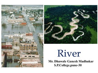
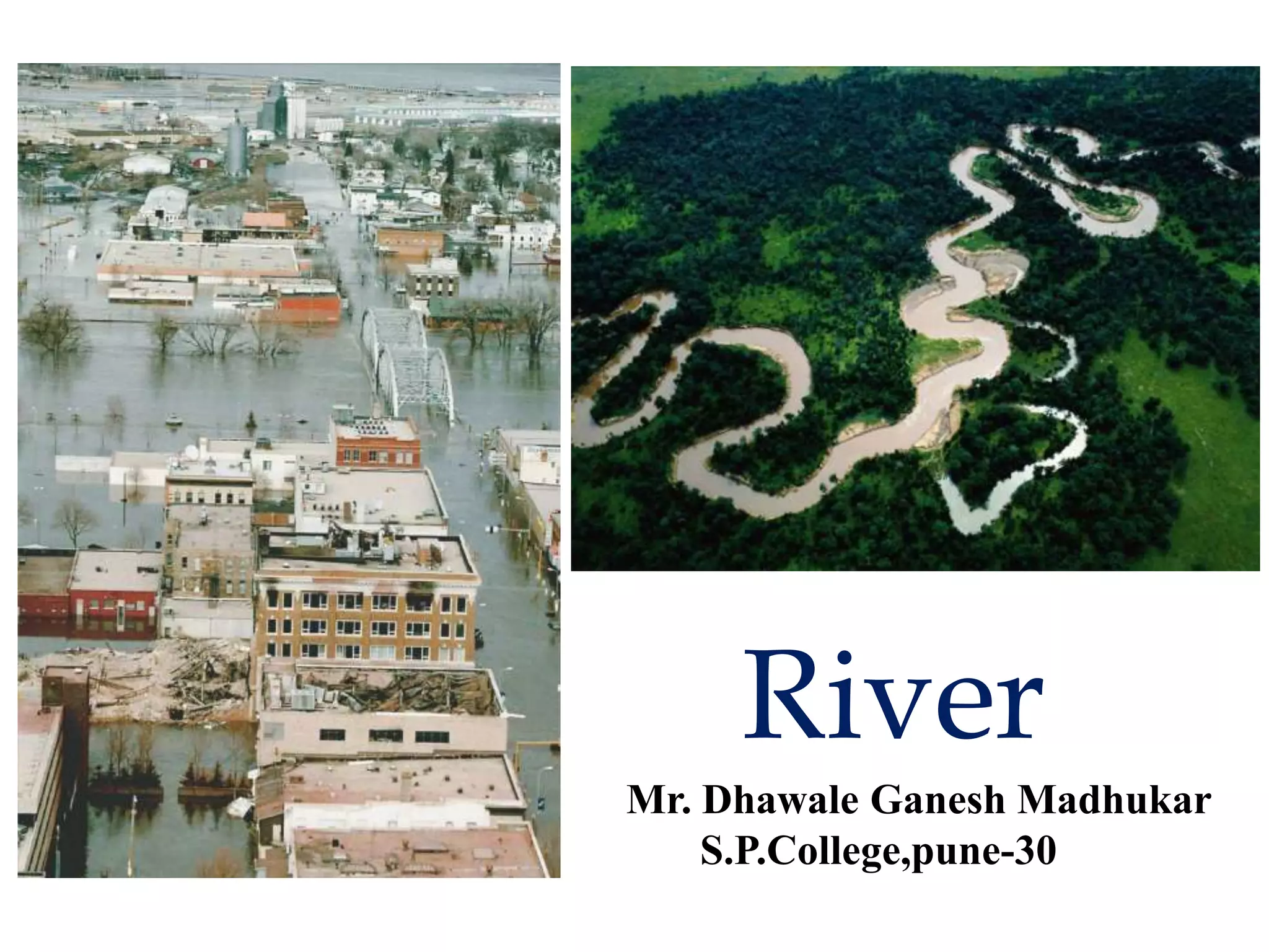
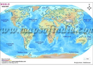
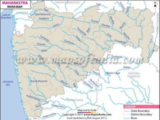
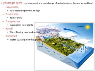
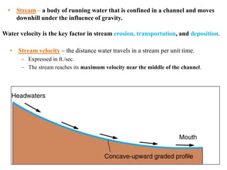
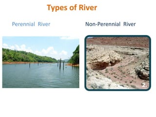
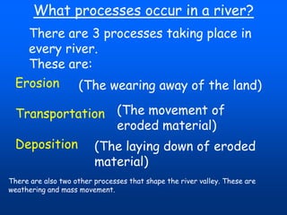
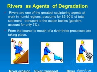
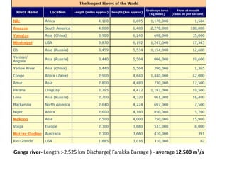
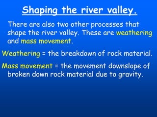
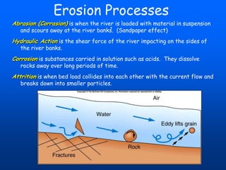
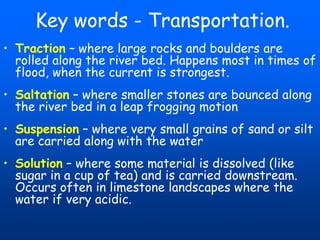
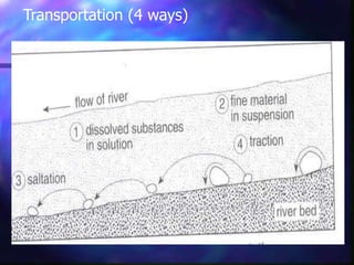
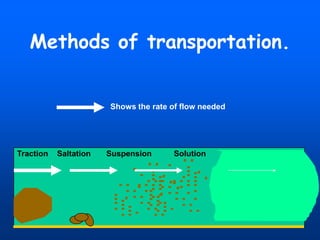
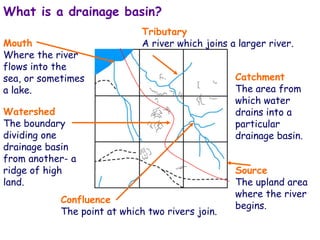
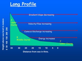
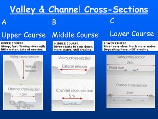
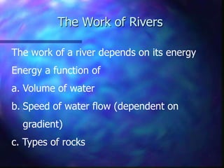
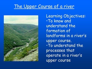
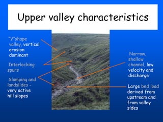
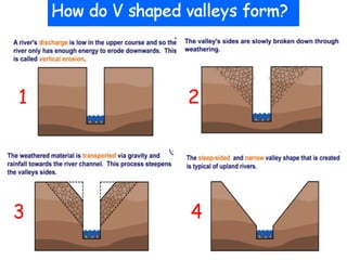
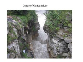
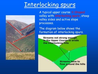
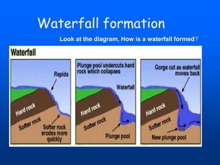
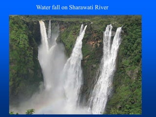
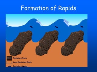
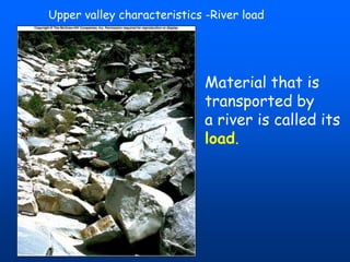
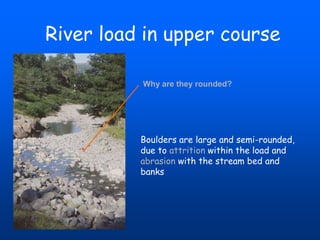
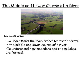
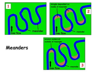
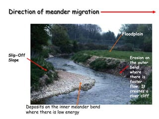
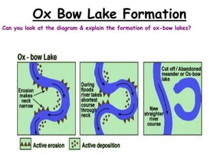
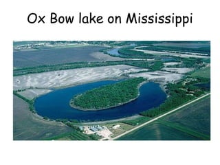
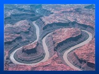
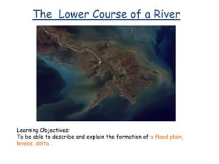
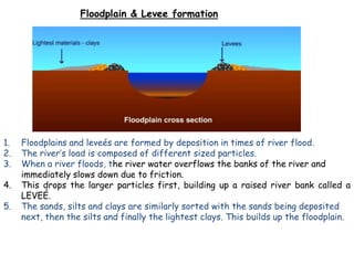
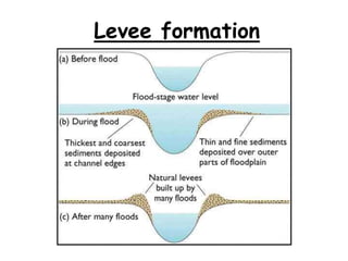
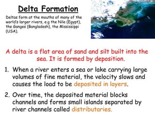
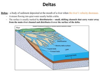
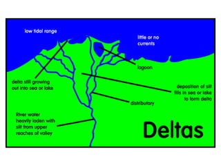
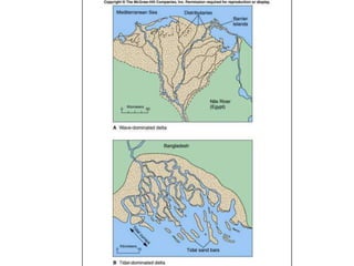
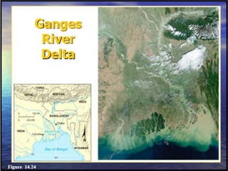
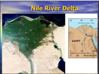
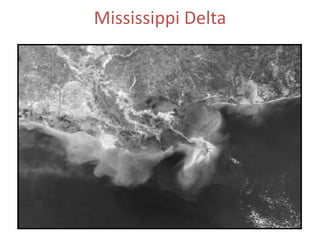
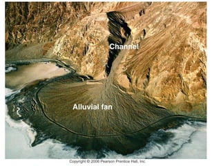
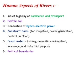
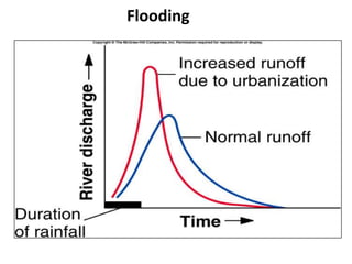
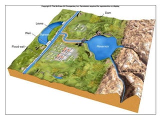
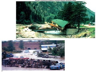
River
Mr. Dhawale Ganesh Madhukar
S.P.College,pune-30
Hydrologic cycle - the movement and interchange of water between the sea, air, and land
– Evaporation
• Solar radiation provides energy

– Precipitation
• Rain or snow

– Hydrologic cycle – the movement and interchange of water between the sea, air, and land.

– Transpiration
• Evaporation from plants

– Runoff
• Water flowing over land surface

– Infiltration
• Water soaking into the ground

Click to view animation
• Stream – a body of running water that is confined in a channel and moves
downhill under the influence of gravity.
Water velocity is the key factor in stream erosion, transportation, and deposition.
• Stream velocity – the distance water travels in a stream per unit time.
– Expressed in ft./sec.
– The stream reaches its maximum velocity near the middle of the channel.
Types of River
Perennial River

Non-Perennial River
What processes occur in a river?
There are 3 processes taking place in
every river.
These are:
Erosion
(The wearing away of the land)
Transportation (The movement of
eroded material)
Deposition (The laying down of eroded
material)
There are also two other processes that shape the river valley. These are
weathering and mass movement.
deposition
Ganga river- Length :-2,525 km Discharge( Farakka Barrage ) - average 12,500 m3/s
Shaping the river valley.
There are also two other processes that
shape the river valley. These are weathering
and mass movement.
Weathering = the breakdown of rock material.
Mass movement = the movement downslope of
broken down rock material due to gravity.
Erosion Processes
.

Abrasion (Corrasion) is when the river is loaded with material in suspension
and scours away at the river banks. (Sandpaper effect)

Hydraulic Action is the shear force of the river impacting on the sides of
the river banks.

Corrosion is substances carried in solution such as acids. They dissolve
rocks away over long periods of time.

Attrition is when bed load collides into each other with the current flow and
breaks down into smaller particles.
Key words - Transportation.
• Traction – where large rocks and boulders are
rolled along the river bed. Happens most in times of
flood, when the current is strongest.
• Saltation – where smaller stones are bounced along
the river bed in a leap frogging motion

• Suspension – where very small grains of sand or silt
are carried along with the water
• Solution – where some material is dissolved (like
sugar in a cup of tea) and is carried downstream.
Occurs often in limestone landscapes where the
water if very acidic.
Transportation (4 ways)
Methods of transportation.

Shows the rate of flow needed

Traction

Saltation

Suspension

Solution
What is a drainage basin?
Mouth
Where the river
flows into the
sea, or sometimes
a lake.

Tributary
A river which joins a larger river.

Watershed
The boundary
dividing one
drainage basin
from another- a
ridge of high
land.
Confluence
The point at which two rivers join.

Catchment
The area from
which water
drains into a
particular
drainage basin.
Source
The upland area
where the river
begins.
Long Profile

A
Upper
Course
0 50 100 150 200 250

Height above sea level in meters.

Gradient/slope decreasing

Velocity/flow increasing
Cumecs/discharge increasing

B
Middle Course

35

30

25

Energy increases

20

15

10

Distance from sea in Kms.

5

C
Lower Course
0
Valley & Channel Cross-Sections
A

B

Upper Course Middle Course

C
Lower Course
The Work of Rivers
The work of a river depends on its energy
Energy a function of
a. Volume of water

b. Speed of water flow (dependent on
gradient)

c. Types of rocks
The Upper Course of a river
Learning Objectives:
•To know and
understand the
formation of
landforms in a river’s
upper course.
•To understand the
processes that
operate in a river’s
upper course
Upper valley characteristics
“V”shape
valley, vertical
erosion
dominant
Interlocking
spurs
Slumping and
landslides very active
hill slopes

Narrow,
shallow
channel, low
velocity and
discharge
Large bed load
derived from
upstream and
from valley
sides
1

2

3

4
Gorge of Ganga River
Interlocking spurs
A typical upper course V-Shaped
valley with interlocking spurs, steep
valley sides and active slope
processes.
The diagram below shows the
formation of interlocking spurs.
Waterfall formation
Look at the diagram, How is a waterfall formed?
Water fall on Sharawati River
Formation of Rapids
Upper valley characteristics -River load

Material that is
transported by
a river is called its
load.
River load in upper course
Why are they rounded?

Boulders are large and semi-rounded,
due to attrition within the load and
abrasion with the stream bed and
banks
The Middle and Lower Course of a River

Learning Objectives

•To understand the main processes that operate
in the middle and lower course of a river.
•To understand how meanders and oxbow lakes
are formed.
Processes operating in the middle course
of a river
Erosion is still an important process.

The river is now flowing over flatter land and so the
dominant direction of erosion is lateral (from side to side).
The river has a greater discharge and so has more energy to
transport material. Material that is transported by a river is
called its load.
Deposition is also an important process and occurs when the
velocity of the river decreases or if the discharge falls due
to a dry spell of weather.
1

2

Meanders
3
Direction of meander migration
Floodplain

Slip-Off
Slope

Erosion on
the outer
bend
where
there is
faster
flow. It
creates a
river cliff

Deposits on the inner meander bend
where there is low energy
Ox Bow Lake Formation
Can you look at the diagram & explain the formation of ox-bow lakes?
Ox Bow lake on Mississippi
The Lower Course of a River

Learning Objectives:
To be able to describe and explain the formation of a flood plain,
levees, delta .
Defintions
Flood plains
• A flood plain is the wide, flat area of land on
either side of the river in its middle and
lower course.
Levees
• Levees are natural embankments of silt along
the banks of a river, which are often several
metres higher than the flood plain.
Floodplain & Levee formation

1.
2.
3.
4.
5.

Floodplains and leveés are formed by deposition in times of river flood.
The river’s load is composed of different sized particles.
When a river floods, the river water overflows the banks of the river and
immediately slows down due to friction.
This drops the larger particles first, building up a raised river bank called a
LEVEÉ.
The sands, silts and clays are similarly sorted with the sands being deposited
next, then the silts and finally the lightest clays. This builds up the floodplain.
Levee formation
Delta Formation
Deltas form at the mouths of many of the
world’s larger rivers, e.g the Nile (Egypt),
the Ganges (Bangladesh), the Mississippi
(USA).

A delta is a flat area of sand and silt built into the
sea. It is formed by deposition.

1. When a river enters a sea or lake carrying large
volumes of fine material, the velocity slows and
causes the load to be deposited in layers.
2. Over time, the deposited material blocks
channels and forms small islands separated by
river channels called distributaries.
Deltas
Deltas – a body of sediment deposited at the mouth of a river when the river’s velocity decreases.
– A stream flowing into quiet water usually builds a delta.
– The surface is usually marked by distributaries – small, shifting channels that carry water away
from the main river channel and distributes it over the surface of the delta.
Mississippi Delta
Alluvial Fans
Human Aspects of Rivers :1.

Chief highway of commerce and transport

2. Fertile soil
3. Generation of hydro-electric power
4. Construct dams (for irrigation, power generation,

control on flood)
5. Fresh water – fishing, domestic consumption,
sewerage, and industrial purpose

6. Political boundaries
Flooding
Human Interference:
Urbanization,
Industrialization,
Water Pollution,
Dam Construction- (Disturbing present ecosystem),
Festival (Ganesh Utsav),
Sand Mafiya.

Ganga Action Plan
 Launched in April 1986 in order to reduce the pollution load on the river.
Spending Rs 901.71 Crores.
Withdrawn on 31 March 2000.
Phase-II of the program was approved in stages from 1993 onwards, and included
the following tributaries of the Ganges: Yamuna, Gomti, Damodar and Mahananda.
Water pollution
Festival (Ganesh Utsav)

Kumbha
Mela
River

River

  • 1.
    River Mr. Dhawale GaneshMadhukar S.P.College,pune-30
  • 5.
    Hydrologic cycle -the movement and interchange of water between the sea, air, and land – Evaporation • Solar radiation provides energy – Precipitation • Rain or snow – Hydrologic cycle – the movement and interchange of water between the sea, air, and land. – Transpiration • Evaporation from plants – Runoff • Water flowing over land surface – Infiltration • Water soaking into the ground Click to view animation
  • 6.
    • Stream –a body of running water that is confined in a channel and moves downhill under the influence of gravity. Water velocity is the key factor in stream erosion, transportation, and deposition. • Stream velocity – the distance water travels in a stream per unit time. – Expressed in ft./sec. – The stream reaches its maximum velocity near the middle of the channel.
  • 7.
    Types of River PerennialRiver Non-Perennial River
  • 8.
    What processes occurin a river? There are 3 processes taking place in every river. These are: Erosion (The wearing away of the land) Transportation (The movement of eroded material) Deposition (The laying down of eroded material) There are also two other processes that shape the river valley. These are weathering and mass movement.
  • 9.
  • 10.
    Ganga river- Length:-2,525 km Discharge( Farakka Barrage ) - average 12,500 m3/s
  • 11.
    Shaping the rivervalley. There are also two other processes that shape the river valley. These are weathering and mass movement. Weathering = the breakdown of rock material. Mass movement = the movement downslope of broken down rock material due to gravity.
  • 12.
    Erosion Processes . Abrasion (Corrasion)is when the river is loaded with material in suspension and scours away at the river banks. (Sandpaper effect) Hydraulic Action is the shear force of the river impacting on the sides of the river banks. Corrosion is substances carried in solution such as acids. They dissolve rocks away over long periods of time. Attrition is when bed load collides into each other with the current flow and breaks down into smaller particles.
  • 13.
    Key words -Transportation. • Traction – where large rocks and boulders are rolled along the river bed. Happens most in times of flood, when the current is strongest. • Saltation – where smaller stones are bounced along the river bed in a leap frogging motion • Suspension – where very small grains of sand or silt are carried along with the water • Solution – where some material is dissolved (like sugar in a cup of tea) and is carried downstream. Occurs often in limestone landscapes where the water if very acidic.
  • 14.
  • 15.
    Methods of transportation. Showsthe rate of flow needed Traction Saltation Suspension Solution
  • 16.
    What is adrainage basin? Mouth Where the river flows into the sea, or sometimes a lake. Tributary A river which joins a larger river. Watershed The boundary dividing one drainage basin from another- a ridge of high land. Confluence The point at which two rivers join. Catchment The area from which water drains into a particular drainage basin. Source The upland area where the river begins.
  • 17.
    Long Profile A Upper Course 0 50100 150 200 250 Height above sea level in meters. Gradient/slope decreasing Velocity/flow increasing Cumecs/discharge increasing B Middle Course 35 30 25 Energy increases 20 15 10 Distance from sea in Kms. 5 C Lower Course 0
  • 18.
    Valley & ChannelCross-Sections A B Upper Course Middle Course C Lower Course
  • 19.
    The Work ofRivers The work of a river depends on its energy Energy a function of a. Volume of water b. Speed of water flow (dependent on gradient) c. Types of rocks
  • 20.
    The Upper Courseof a river Learning Objectives: •To know and understand the formation of landforms in a river’s upper course. •To understand the processes that operate in a river’s upper course
  • 21.
    Upper valley characteristics “V”shape valley,vertical erosion dominant Interlocking spurs Slumping and landslides very active hill slopes Narrow, shallow channel, low velocity and discharge Large bed load derived from upstream and from valley sides
  • 22.
  • 23.
  • 24.
    Interlocking spurs A typicalupper course V-Shaped valley with interlocking spurs, steep valley sides and active slope processes. The diagram below shows the formation of interlocking spurs.
  • 25.
    Waterfall formation Look atthe diagram, How is a waterfall formed?
  • 26.
    Water fall onSharawati River
  • 27.
  • 28.
    Upper valley characteristics-River load Material that is transported by a river is called its load.
  • 29.
    River load inupper course Why are they rounded? Boulders are large and semi-rounded, due to attrition within the load and abrasion with the stream bed and banks
  • 30.
    The Middle andLower Course of a River Learning Objectives •To understand the main processes that operate in the middle and lower course of a river. •To understand how meanders and oxbow lakes are formed.
  • 31.
    Processes operating inthe middle course of a river Erosion is still an important process. The river is now flowing over flatter land and so the dominant direction of erosion is lateral (from side to side). The river has a greater discharge and so has more energy to transport material. Material that is transported by a river is called its load. Deposition is also an important process and occurs when the velocity of the river decreases or if the discharge falls due to a dry spell of weather.
  • 32.
  • 33.
    Direction of meandermigration Floodplain Slip-Off Slope Erosion on the outer bend where there is faster flow. It creates a river cliff Deposits on the inner meander bend where there is low energy
  • 34.
    Ox Bow LakeFormation Can you look at the diagram & explain the formation of ox-bow lakes?
  • 35.
    Ox Bow lakeon Mississippi
  • 37.
    The Lower Courseof a River Learning Objectives: To be able to describe and explain the formation of a flood plain, levees, delta .
  • 38.
    Defintions Flood plains • Aflood plain is the wide, flat area of land on either side of the river in its middle and lower course. Levees • Levees are natural embankments of silt along the banks of a river, which are often several metres higher than the flood plain.
  • 39.
    Floodplain & Leveeformation 1. 2. 3. 4. 5. Floodplains and leveés are formed by deposition in times of river flood. The river’s load is composed of different sized particles. When a river floods, the river water overflows the banks of the river and immediately slows down due to friction. This drops the larger particles first, building up a raised river bank called a LEVEÉ. The sands, silts and clays are similarly sorted with the sands being deposited next, then the silts and finally the lightest clays. This builds up the floodplain.
  • 40.
  • 41.
    Delta Formation Deltas format the mouths of many of the world’s larger rivers, e.g the Nile (Egypt), the Ganges (Bangladesh), the Mississippi (USA). A delta is a flat area of sand and silt built into the sea. It is formed by deposition. 1. When a river enters a sea or lake carrying large volumes of fine material, the velocity slows and causes the load to be deposited in layers. 2. Over time, the deposited material blocks channels and forms small islands separated by river channels called distributaries.
  • 42.
    Deltas Deltas – abody of sediment deposited at the mouth of a river when the river’s velocity decreases. – A stream flowing into quiet water usually builds a delta. – The surface is usually marked by distributaries – small, shifting channels that carry water away from the main river channel and distributes it over the surface of the delta.
  • 47.
  • 48.
  • 49.
    Human Aspects ofRivers :1. Chief highway of commerce and transport 2. Fertile soil 3. Generation of hydro-electric power 4. Construct dams (for irrigation, power generation, control on flood) 5. Fresh water – fishing, domestic consumption, sewerage, and industrial purpose 6. Political boundaries
  • 50.
  • 53.
    Human Interference: Urbanization, Industrialization, Water Pollution, DamConstruction- (Disturbing present ecosystem), Festival (Ganesh Utsav), Sand Mafiya. Ganga Action Plan  Launched in April 1986 in order to reduce the pollution load on the river. Spending Rs 901.71 Crores. Withdrawn on 31 March 2000. Phase-II of the program was approved in stages from 1993 onwards, and included the following tributaries of the Ganges: Yamuna, Gomti, Damodar and Mahananda.
  • 54.
  • 55.