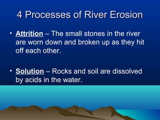
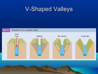
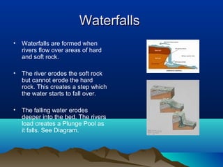
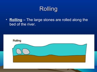
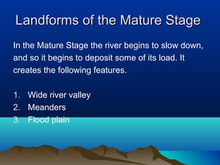
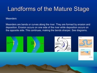
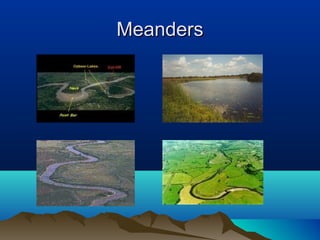
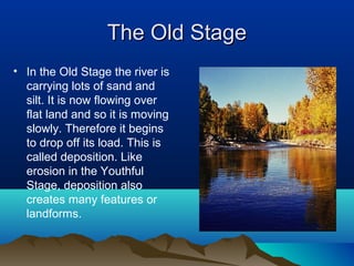
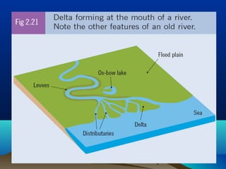
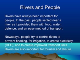
Rivers
Common River Terms
• Source – The place where a river begins.
• Course – The route the river takes to the
  sea
• Tributary – A small river that joins a larger
  river.
• Confluence – The point where the
  tributary joins the river.
Common River Terms
• Mouth – The point where the river enters
  the sea.
• Estuary – The part of the mouth that is
  tidal.
• Basin – The area of land drained by a
  river.
• Watershed – The high ground separating
  one river basin from another.
The River’s Journey
• Rivers usually begin in the mountains.
• They flow downhill onto flat land and into the sea.
The Shannon’s Journey
•   The River Shannon is
    Ireland’s longest river.

•   It flows from the Cuilcagh
    Mountains in Co. Leitrim
    to the Atlantic Ocean on
    the west coast of Ireland.
The Stages of a River’s Journey
•   As the river flows from it’s source to the sea it goes through 3
    stages. These are,

•   The Upper or Youthful Stage
•   The Middle or Mature Stage
•   The Lower or Old Stage
The Youthful River
• The youthful river has a small amount of
  water but it travels very quickly down the
  steep mountain slope.

• Most of its energy is used to erode (wear
  away) the landscape.

• This erosion (wearing away) occurs in 4
  ways.
4 Processes of River Erosion
• Hydraulic Action – The force of the
  moving water wears away the banks and
  bed of the river.

• Abrasion – Small stones carried by the
  river wear away at the the banks and bed
  of the river.
4 Processes of River Erosion
• Attrition – The small stones in the river
  are worn down and broken up as they hit
  off each other.

• Solution – Rocks and soil are dissolved
  by acids in the water.
Landforms of the Youthful Stage
•   All of the erosion by the river creates features
    or landforms on the landscape.

Three features created in the youthful stage are,

1. V-shaped Valleys
2. Interlocking Spurs
3. Waterfalls
V-Shaped Valleys
• V-shaped valleys get their name from their
  shape. The river erodes the landscape and
  creates a valley in the shape of a V.

• This occurs because of Vertical Erosion. The
  river cuts down into the river bed, making it
  deeper. It creates a narrow deep valley.
  Mechanical weathering and mass movement
  create the V shape. See Diagram.
V-Shaped Valleys
Interlocking Spurs
• As the rivers flows it meets areas of hard
  rock. It cannot erode these so it flows
  around them.

• This creates a zigzag course. See
  Diagram.
Waterfalls
•   Waterfalls are formed when
    rivers flow over areas of hard
    and soft rock.

•   The river erodes the soft rock
    but cannot erode the hard
    rock. This creates a step which
    the water starts to fall over.

•   The falling water erodes
    deeper into the bed. The rivers
    load creates a Plunge Pool as
    it falls. See Diagram.
Waterfalls
The Mature Stage
• We now know that during the youthful stage the
  river is mainly eroding the landscape.

• Erosion breaks off particles of rock and soil from
  the bed and banks of the river. They are carried
  along by the river and are known as the Load.

• The load is carried from upland to lowland areas.
  This process is called River Transportation.
River Transportation
All rivers carry material in them. This material is carried by
the river as it flows along.

Rivers can carry large stones, small stones, sand, and
other dissolved minerals.

All of this material in the river is called the river’s Load

When the river moves its load we call this River Transportation
River Transportation
• Transportation occurs in 4 ways.

•   1. Rolling
•   2. Bouncing
•   3. Suspension
•   4. Solution
River Transportation


Suspension
                         Solution


             Rolling                Bouncing
Rolling
• Rolling – The large stones are rolled along the
  bed of the river.


    Rolling
Bouncing
Bouncing – The smaller pebbles are bounced
along the bed of the river.


     Bouncing
Suspension
Suspension – Light material like sand and silt are
carried along (floating) in the water.
Solution
4.   Solution – Dissolved materials are carried along by
     the river.


     Solution
Landforms of the Mature Stage
In the Mature Stage the river begins to slow down,
and so it begins to deposit some of its load. It
creates the following features.

1. Wide river valley
2. Meanders
3. Flood plain
Landforms of the Mature Stage
Wider River Valley

In the mature stage the river moves from
side to side and the valley becomes wide
and flat. Weathering and Mass Movement
continue to wear away at the sides of the
valley. See diagram.
Landforms of the Mature Stage
Meanders

Meanders are bends or curves along the river. They are formed by erosion and
deposition. Erosion occurs on one side of the river while deposition occurs on
the opposite side. This continues, making the bends sharper. See diagrams.
Meanders
Landforms of the Mature Stage
Flood Plain

A flood plain is the flat area of land on either side
of the river. After heavy rain the river sometimes
floods. The water spreads out over the land on
either side of the river. When the river retreats it
leaves behind a thin layer of alluvium. After many
floods a thick layer of alluvium is created. This is
very fertile soil.
The Old Stage
• In the Old Stage the river is
  carrying lots of sand and
  silt. It is now flowing over
  flat land and so it is moving
  slowly. Therefore it begins
  to drop off its load. This is
  called deposition. Like
  erosion in the Youthful
  Stage, deposition also
  creates many features or
  landforms.
Landforms of the Old Stage
The following features or landforms are
created by river deposition in the Old Stage.

1. Ox-Bow Lakes
2. Levees
3. Delta
Landforms of the Old Stage
Ox-Bow Lakes

An ox-bow lake is a horseshoe
shaped lake found beside a
river. Ox-bow lakes are formed
when continued erosion and
deposition create very
pronounced meanders.

Eventually the river cuts through
the neck of the meander.
Deposition then occurs which
leaves the ox-bow lake
separated from the river.
How an Ox-Bow Lake is Made
Landforms of the Old Stage
Levees

Levees are raised banks of deposited material
found along the banks of the river. When the river
floods and spreads out over the floodplain, the
heaviest material is deposited close to the river.
Over time and after many periods of flooding this
deposited material forms levees along the banks of
the river.
Levees – Raised Banks
Landforms of the Old Stage
Delta

A Delta is a triangular shaped piece of land
which is formed at the mouth of the river. As
the river enters the sea it drops off all the
remaining material it is carrying. This
material builds up to form new land. The river is
forced to break up into smaller channels called
distributaries.
Rivers and People
Rivers have always been important for
people. In the past, people settled near a
river as it provided them with food, water,
defence, and an easy method of transport.

Nowadays, people try to control rivers to
prevent flooding, for irrigation, to create electricity
(HEP), and to create improved transport links.
Rivers are also important for tourism and leisure.
Hydro-Electric Power (HEP)
Engineers build dams across
the river.

They can then control the
flow of water in the river.

They release the water and
use it’s power to turn large
turbines.

Turning these turbines
creates power which is used to
generate electricity.
Rivers

Rivers

  • 1.
  • 3.
    Common River Terms •Source – The place where a river begins. • Course – The route the river takes to the sea • Tributary – A small river that joins a larger river. • Confluence – The point where the tributary joins the river.
  • 4.
    Common River Terms •Mouth – The point where the river enters the sea. • Estuary – The part of the mouth that is tidal. • Basin – The area of land drained by a river. • Watershed – The high ground separating one river basin from another.
  • 5.
    The River’s Journey •Rivers usually begin in the mountains. • They flow downhill onto flat land and into the sea.
  • 6.
    The Shannon’s Journey • The River Shannon is Ireland’s longest river. • It flows from the Cuilcagh Mountains in Co. Leitrim to the Atlantic Ocean on the west coast of Ireland.
  • 8.
    The Stages ofa River’s Journey • As the river flows from it’s source to the sea it goes through 3 stages. These are, • The Upper or Youthful Stage • The Middle or Mature Stage • The Lower or Old Stage
  • 9.
    The Youthful River •The youthful river has a small amount of water but it travels very quickly down the steep mountain slope. • Most of its energy is used to erode (wear away) the landscape. • This erosion (wearing away) occurs in 4 ways.
  • 10.
    4 Processes ofRiver Erosion • Hydraulic Action – The force of the moving water wears away the banks and bed of the river. • Abrasion – Small stones carried by the river wear away at the the banks and bed of the river.
  • 11.
    4 Processes ofRiver Erosion • Attrition – The small stones in the river are worn down and broken up as they hit off each other. • Solution – Rocks and soil are dissolved by acids in the water.
  • 12.
    Landforms of theYouthful Stage • All of the erosion by the river creates features or landforms on the landscape. Three features created in the youthful stage are, 1. V-shaped Valleys 2. Interlocking Spurs 3. Waterfalls
  • 13.
    V-Shaped Valleys • V-shapedvalleys get their name from their shape. The river erodes the landscape and creates a valley in the shape of a V. • This occurs because of Vertical Erosion. The river cuts down into the river bed, making it deeper. It creates a narrow deep valley. Mechanical weathering and mass movement create the V shape. See Diagram.
  • 14.
  • 15.
    Interlocking Spurs • Asthe rivers flows it meets areas of hard rock. It cannot erode these so it flows around them. • This creates a zigzag course. See Diagram.
  • 17.
    Waterfalls • Waterfalls are formed when rivers flow over areas of hard and soft rock. • The river erodes the soft rock but cannot erode the hard rock. This creates a step which the water starts to fall over. • The falling water erodes deeper into the bed. The rivers load creates a Plunge Pool as it falls. See Diagram.
  • 19.
  • 20.
    The Mature Stage •We now know that during the youthful stage the river is mainly eroding the landscape. • Erosion breaks off particles of rock and soil from the bed and banks of the river. They are carried along by the river and are known as the Load. • The load is carried from upland to lowland areas. This process is called River Transportation.
  • 21.
    River Transportation All riverscarry material in them. This material is carried by the river as it flows along. Rivers can carry large stones, small stones, sand, and other dissolved minerals. All of this material in the river is called the river’s Load When the river moves its load we call this River Transportation
  • 22.
    River Transportation • Transportationoccurs in 4 ways. • 1. Rolling • 2. Bouncing • 3. Suspension • 4. Solution
  • 23.
    River Transportation Suspension Solution Rolling Bouncing
  • 24.
    Rolling • Rolling –The large stones are rolled along the bed of the river. Rolling
  • 25.
    Bouncing Bouncing – Thesmaller pebbles are bounced along the bed of the river. Bouncing
  • 26.
    Suspension Suspension – Lightmaterial like sand and silt are carried along (floating) in the water.
  • 27.
    Solution 4. Solution – Dissolved materials are carried along by the river. Solution
  • 28.
    Landforms of theMature Stage In the Mature Stage the river begins to slow down, and so it begins to deposit some of its load. It creates the following features. 1. Wide river valley 2. Meanders 3. Flood plain
  • 29.
    Landforms of theMature Stage Wider River Valley In the mature stage the river moves from side to side and the valley becomes wide and flat. Weathering and Mass Movement continue to wear away at the sides of the valley. See diagram.
  • 31.
    Landforms of theMature Stage Meanders Meanders are bends or curves along the river. They are formed by erosion and deposition. Erosion occurs on one side of the river while deposition occurs on the opposite side. This continues, making the bends sharper. See diagrams.
  • 33.
  • 34.
    Landforms of theMature Stage Flood Plain A flood plain is the flat area of land on either side of the river. After heavy rain the river sometimes floods. The water spreads out over the land on either side of the river. When the river retreats it leaves behind a thin layer of alluvium. After many floods a thick layer of alluvium is created. This is very fertile soil.
  • 35.
    The Old Stage •In the Old Stage the river is carrying lots of sand and silt. It is now flowing over flat land and so it is moving slowly. Therefore it begins to drop off its load. This is called deposition. Like erosion in the Youthful Stage, deposition also creates many features or landforms.
  • 36.
    Landforms of theOld Stage The following features or landforms are created by river deposition in the Old Stage. 1. Ox-Bow Lakes 2. Levees 3. Delta
  • 37.
    Landforms of theOld Stage Ox-Bow Lakes An ox-bow lake is a horseshoe shaped lake found beside a river. Ox-bow lakes are formed when continued erosion and deposition create very pronounced meanders. Eventually the river cuts through the neck of the meander. Deposition then occurs which leaves the ox-bow lake separated from the river.
  • 38.
    How an Ox-BowLake is Made
  • 39.
    Landforms of theOld Stage Levees Levees are raised banks of deposited material found along the banks of the river. When the river floods and spreads out over the floodplain, the heaviest material is deposited close to the river. Over time and after many periods of flooding this deposited material forms levees along the banks of the river.
  • 40.
  • 41.
    Landforms of theOld Stage Delta A Delta is a triangular shaped piece of land which is formed at the mouth of the river. As the river enters the sea it drops off all the remaining material it is carrying. This material builds up to form new land. The river is forced to break up into smaller channels called distributaries.
  • 43.
    Rivers and People Rivershave always been important for people. In the past, people settled near a river as it provided them with food, water, defence, and an easy method of transport. Nowadays, people try to control rivers to prevent flooding, for irrigation, to create electricity (HEP), and to create improved transport links. Rivers are also important for tourism and leisure.
  • 44.
    Hydro-Electric Power (HEP) Engineersbuild dams across the river. They can then control the flow of water in the river. They release the water and use it’s power to turn large turbines. Turning these turbines creates power which is used to generate electricity.