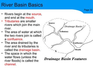
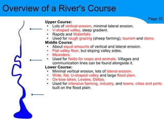
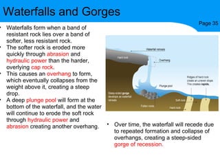
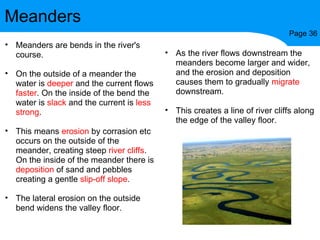
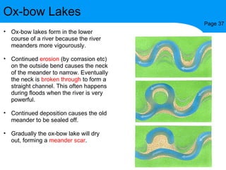
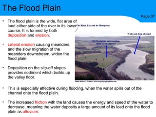
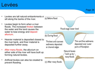
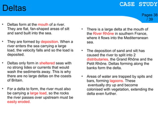
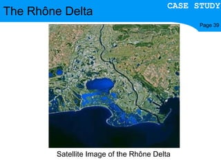
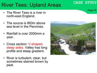
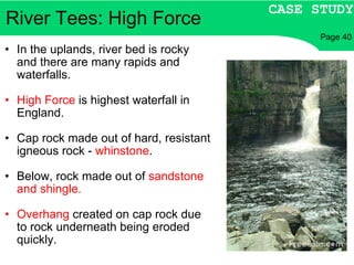
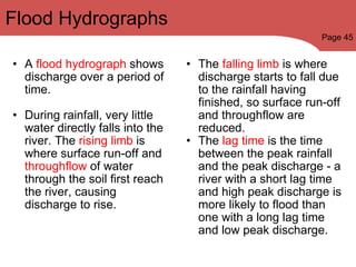
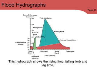
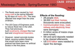
Revision of Rivers By Alex McCormick, Dom Brundler,  Robert Rossiter and George Zeng
The Specification The AQA specification is on the next two slides. It is split into two main sections: Firstly, a section about processes and landforms. Secondly, a section about the interaction between humans and rivers. (Effects of flooding and strategies to prevent flooding etc) The final column in the specification is  scale.  R/L  means you need to talk on a regional and local scale,  R/L/N  means you need to talk on a regional, local and national scale.
Specification Guidance Scale The earth's crust is modified by  fluvial processes  which result in distinctive landforms . Long and cross profiles,  processes of erosion  (hydraulic power, corrosion, corrasion, attrition),  transport  (traction, saltation, suspension, solution) and deposition .       The  characteristics and formation  of waterfalls, gorges, meanders, ox-bow lakes, levees, flood plains and deltas.     Recognise and describe  fluvial features on Ordnance Survey maps and photographs. How a  river profile changes downstream  and the relative importance of the processes at work  such as the typical V shaped valley in the upper course where vertical corrasion dominates .     Students will be expected to be able to  name an example, describe each feature and to explain its formation   making reference to the  processes  at work.   There is an opportunity in this section to revise the OS skills as on page 37 as well as to introduce photographic interpretation etc.     R/L                 R/L               R/L
Specification Guidance Scale The  interaction between people and fluvial environments.   River basin management  issues, the  causes and effects of flooding  in river basins in the context of both  LEDCs and MEDCs.     The   short, medium and long term strategies   used to attempt to manage the floods. Contemporary issues concerning use of  hard vs soft strategies   and attempts to achieve   sustainability .   The  social, economic, environmental and political issues  that have an impact upon strategies and the values and attitudes of interested groups.   River basin management issues should be studied in the context of both  LEDCs eg. Bangladesh  and  MEDCs eg. the European floods of the 1990s . One  case study  from the MEDC and LEDC should be chosen to study the  physical and human causes of flooding and the impact of the floods.  TV news is a good source of up to date information.   Flood management should include  efforts to prevent flooding and strategies used to ameliorate the impact.  Candidates should be aware of  how and why the methods used are different between the LEDC and MEDC  and now currently there is a move away from hard engineering e.g.  dams  on the Colorado to softer approaches e.g.  flood plain zoning, improved warning system .   Opportunities to use ICT to research flood disasters.     R/L                         N/R/L
River Basin Basics Page 32 Rivers begin at the  source , and end at the  mouth . Tributaries  are smaller rivers which join the main river. The area of water at which the two rivers join is called a  confluence . The area drained by the river and its tributaries is called the  drainage basin . The space in which the water flows (unless the river floods) is called the  channel .
Processes of Erosion Page 34 There are four processes by which a river erodes. However, these are exactly the same as the four processes used in coastal erosion. Hydraulic power  is simply the force of the water on the bed and banks of the river removing material. It is particularly powerful during floods. Corrasion/Abrasion  involves particles of sand, pebbles and boulders that are carried by the river rubbing against the river bed and banks, wearing them away. Corrosion  is when rock minerals from the bed and banks dissolve into the river water, due to its slight acidity. Attrition  involves the river's load colliding against itself, breaking into smaller, rounder pieces of rock, until they are reduced to particles of sand and silt.
Transportation of Material Page 34 Traction  - Large boulders roll along the river bed. Saltation  - Smaller pebbles bounce along the river bed, picked up by the flow of the river. Suspension  - Fine sand and silt-sized particles are carried along in the flow, giving the river a brown appearance. Solution  - Minerals (eg limestone and chalk) are dissolved in the water and carried along with the flow A river carries more material if: the  volume of water  is greater, the  velocity  of the water is greater, and the local rock types are more easily eroded. When a river loses energy (due to  lower velocity, higher friction with the land  etc) it will drop some of its load, causing  deposition . The dropped load is called  alluvium . The heavier rocks are always dropped first.
Upper Course: Lots of  vertical erosion , minimal lateral erosion. V-shaped valley , steep gradient. Rapids and  Waterfalls. Used for  rough grazing  (sheep farming),  tourism  and  dams . Middle Course : About  equal amounts  of vertical and lateral erosion. Flat   valley floor , but sloping valley sides. Meanders. Used for  fields for crops and animals . Villages and communication lines can be found alongside it. Lower Course: Minimal vertical erosion, lots of  lateral erosion . Wide, flat,   U-shaped valley  and large  flood plain . Ox-bow lakes, Levées, Deltas . Used for  intensive farming, industry , and  towns, cities and ports  built on the flood plain. Overview of a River's Course Page 33
Waterfalls and Gorges Page 35 Waterfalls form when a band of resistant rock lies over a band of softer, less resistant rock. The softer rock is eroded more quickly through  abrasion  and  hydraulic power  than the harder, overlying  cap rock . This causes an  overhang  to form, which eventually collapses from the weight above it, creating a steep drop. A deep  plunge pool  will form at the bottom of the waterfall, and the water will continue to erode the soft rock through  hydraulic power  and  abrasion  creating another overhang. Over time, the waterfall will recede due to repeated formation and collapse of overhangs, creating a steep-sided  gorge of recession.
Meanders Page 36 Meanders are bends in the river's course.    On the outside of a meander the water is  deeper  and the current flows  faster . On the inside of the bend the water is  slack  and the current is  less strong .    This means  erosion  by corrasion etc occurs on the outside of the meander, creating steep  river cliffs . On the inside of the meander there is  deposition  of sand and pebbles creating a gentle  slip-off slope .   The lateral erosion on the outside bend widens the valley floor.   As the river flows downstream the meanders become larger and wider, and the erosion and deposition causes them to gradually  migrate  downstream.    This creates a line of river cliffs along the edge of the valley floor.  
Ox-bow Lakes Page 37 Ox-bow lakes form in the lower course of a river because the river meanders more vigourously.   Continued  erosion  (by corrasion etc) on the outside bend causes the neck of the meander to narrow. Eventually the neck is  broken through  to form a straight channel. This often happens during floods when the river is very powerful.   Continued deposition causes the old meander to be sealed off.   Gradually the ox-bow lake will dry out, forming a  meander scar .     
The Flood Plain Page 37 The flood plain is the wide, flat area of land either side of the river in its lower course. It is formed by both  deposition  and  erosion . Lateral erosion  causing meanders, and the slow migration of the meanders downstream, widen the flood plain. Deposition on the slip-off slopes provides sediment which builds up the valley floor. This is especially effective during flooding, when the water spills out of the channel onto the flood plain.  The increased  friction  with the land causes the energy and speed of the water to decrease, meaning the water deposits a large amount of its load onto the flood plain as  alluvium .
Levées Page 38 Levées are tall natural embankments of silt along the banks of the river. Levées begin to form when a river floods. The increased  friction  between the water and the land causes the water to lose energy and  deposit alluvium . Heavier material is deposited closest to the river bank, and finer material is deposited further away. After many floods,  the alluvium on either side of the river will have built up, forming natural levées. Artificial levées can also be created to prevent flooding.
Deltas Pages 38 / 39 Deltas form at the  mouth  of a river. They are flat, fan-shaped areas of silt and sand built into the sea. They are formed by  deposition . When a river enters the sea carrying a large load, the velocity falls and so the load is deposited. Deltas only form in  sheltered  seas with no strong tides or currents that would wash the sediments away. This is why there are no large deltas on the coasts of Britain. For a delta to form, the river must also be carrying a  large load , so the rocks the river passes over upstream must be  easily eroded. There is a large delta at the mouth of the  River Rhône  in southern France, where it flows into the Mediterranean sea. The deposition of sand and silt has caused the river to split into 2  distributaries,  the Grand Rhône and the Petit Rhône. Deltas forming along the banks form the delta. Areas of water are trapped by spits and bars, forming  lagoons.  These    eventually dry up and become colonised with vegetation, extending the delta even further. CASE STUDY
The Rhône Delta Page 39 CASE STUDY Satellite Image of the Rhône Delta
The River Tees is a river in north-east England. The source is 893m above sea level in the Pennines. Rainfall is over 2000mm a year. Cross section:  V-shaped, steep sides.  Valley has long profile and steep gradient. River is turbulent, clear, but sometimes stained brown by peat.  River Tees: Upland Areas CASE STUDY Page 40
River Tees: High Force In the uplands, river bed is rocky and there are many rapids and waterfalls. High Force  is highest waterfall in England. Cap rock made out of hard, resistant igneous rock -  whinstone . Below, rock made out of  sandstone and shingle. Overhang  created on cap rock due to rock underneath being eroded quickly. CASE STUDY Page 40
River Tees: Upper Course Land Uses Settlement and Communications: The lack of flat land makes it difficult to build settlements and communications. Population density is very low because of  few employment opportunities . Mainly just small  villages and farms  on the moorlands. Water Supply: Water quality is very high in the valley, and is suitable as drinking water for homes and industry. High rainfall gives reliable water supply. There are  reservoirs  for water supply and flood control. CASE STUDY Page 41
Sheep Farming: One of the major land uses is  rough grazing  for sheep. Land is unsuitable for crops, due to  steep sides  and soil  too thin/acidic . Where slopes are less steep, occasional crop is grown with the help of fertilizers. Dairy cattle may also be grazed. Tourism: Many visitors to the area are attracted to the open moorland, High Force, nature trails, footpaths, villages and more. Visitors provide  employment and income  to the local people - hotels, restuarants, visitor centres. But tourism also brings  congestion, litter, overcrowding  etc. River Tees: Upper Course Land Uses CASE STUDY Page 41
River Tees: Upper Course Land Uses Industry: The upper course once had a lead mining industry, now the disused mines are attractive to visitors. Limited employment in forestry and various craft industries.  No real large-scale industry. Whinstone quarried, a  chemical and pharmaceuticals  company is also located in the upper course. CASE STUDY Page 41
In the Lower Course: The river  widens  and starts to meander. More  settlements  and bridging points can be found. There are many  meanders , several were cut during 19th Century to shorten river for boats navigating upstream. River flows into the  estuary  where there are large areas of  mud flats  - important for wildlife. River Tees: Upland Areas CASE STUDY Page 42
The lower course is more  urbanised  and  industrialised . Industries such as  steelworks  and  chemical works  are located near Teesside. Industry in Teesside is well placed to receive oil and gas from fields in the North Sea. Heavy industry takes advantage of  flat and relatively cheap land . Land is easily reclaimed and there is a good source of labour and a good transport network nearby. The port allows  import  of raw materials and  export  of finished goods. River Tees: Upland Areas CASE STUDY Page 42
It stores water when there is lots of water and it releases water in times of low-flow. River Tees: River Basin Management The river has long history of flooding. There is also a  large population  and  many industries  all requiring a water supply. The river is managed in order to control flooding and to increase its potential for  tourism/recreation . Cow Green Reservoir  was built in 1970 to provide water supply for industries as well as to regulate river flow. CASE STUDY Page 42
The  Tees Barrage  increases water quality and recreational value of lower Tees. The water is  fresher  and  cleaner  as it does not mix with tidal salt water. The barrage also  reduces risk of flooding  at high tide or during storm surge. The barrage has acted as a catalyst for investments in building  offices, houses  etc. River Tees: Lower Valley Management Dredging  the Channel:  Improves  navigation  by maintaining a deep-water channel. There has also been some dredging in the upper parts of the estuary to  reduce the flood risk . Cutting Meanders: Stretches of the river have been  artificially straightened , this allows the water to move faster along the channel, reducing the flood risk. CASE STUDY Page 43
Yarm's Flood Defence Scheme: The town of Yarm is inside bend of large meander, so it is prone to flooding. £2.1 million defence system was built:  Reinforced concrete walls  with flood gates for people and vehicles,  earth embankments ,  gabions  to protect walls/ embankments from erosion. The scheme incorporates features designed to reduce the visual impact of walls e.g. fishing platforms, planting trees. There have also been better  flood warning  systems. Also, to prevent damage,  building on low-lying and flood-prone land is discouraged . River Tees: Lower Valley Management CASE STUDY Page 43
River regime is the variation of  discharge  (cubic metres per second passing a certain point in the river) throughout the year.   An  even regime  has little variation throughout the year.   Snow melt during summer or high summer rainfall causes a  summer maximum of discharge .   Higher rainfall in winter (e.g. in Britain) causes a  winter maximum of discharge . River Regimes Page 44
River Regimes An example of a winter maximum of discharge for the River Severn. Page 44
Flooding occurs in the lower course of a river, creating a  flood plain . Flooding can be caused by:   Long continuous periods of rainfall, A cloudburst in a thunderstorm causing large amounts of run-off, Sudden increases in temperature melting snow/ice left over from winter. Human activities also affect flooding:  Urbanisation leaves concrete surfaces  impermeable  to water, increasing surface run-off, Deforestation decreases  interception  by the trees, Occasional disasters such as burst dams occur. Flooding Page 44
Flood Prevention There are many ways that flooding can be prevented or their effects reduced: Rivers beds can be  dredged  and levées can be  artificially heightened . Dams and reservoirs provide a source of  water storage  that can be easily controlled. Planting trees increases the amount of  interception . Straightening meanders  increases the flow of water through a stretch of river, reducing the risk of flooding. Flood warning systems warn people in advance that a flood is likely, giving time to  prepare  for the flood (e.g. sandbags). Land use zonation  locates pastures and crops closer to a river, with settlement  located further away, reducing the risk of flooding to homes. Page 45
A  flood hydrograph  shows discharge over a period of time. During rainfall, very little water directly falls into the river. The  rising limb  is where surface run-off and  throughflow  of water through the soil first reach the river, causing discharge to rise. The  falling limb  is where discharge starts to fall due to the rainfall having finished, so surface run-off and throughflow are reduced. The  lag time  is the time between the peak rainfall and the peak discharge - a river with a short lag time and high peak discharge is more likely to flood than one with a long lag time and low peak discharge. Flood Hydrographs Page 45
Flood Hydrographs Page 45 This hydrograph shows the rising limb, falling limb and lag time.
Mississippi Floods - Spring/Summer 1993 The floods were caused by  high snow melt  in the spring followed by 50 days of  heavy rain . The area affected was larger than the area of Britain. The US Corps of Engineers work to reduce flood risk in the USA. They had previously built  revetments ;  dredged  the  river bed and  straightened meanders .   However, raised concrete levées failed, causing sudden flooding that would have been more gradual had there been no artificial levées in the first place. Effects of the flooding: 28 people  died , 36,000  lost their homes , thousands were evacuated,  Communication lines, road, railway and electricity lines  were damaged,  6 million acres of maize crops were ruined,  Silt and sand deposits needed to be cleared afterwards,  US  $10 billion  were needed to repair the damage. Page 46 CASE STUDY
This shows the extent of the flooding compared to the normal view of the river Mississippi. CASE STUDY Page 46
Flooding in an LEDC - Bangladesh Bangladesh is a country situated on the  delta  formed by the  Ganges, Meghna  and  Bhahmaputra  rivers. As a result, it commonly faces cyclones and flooding. Advantages of Flooding:   One third of the country's cropland is flooded every year,  renewing the fertile thicknesses  of silt. The watery environment provides perfect conditions for two main crops -  rice  (for food) and  jute  (for export). Farmers regard 'normal' flooding as  beneficial  to soil and crops. Page 230 CASE STUDY Disadvantages of Flooding:   Hurricane force winds from cyclones cause  coastal flooding . Heavy monsoon rains cause  river flooding . Almost the entire country has a flood risk due to being  below 10m  above sea level. Crops are destroyed, people are killed and millions left homeless. Outbreaks of  typhoid and cholera  are caused by  contaminated drinking water supplies .
Sept. 1998 saw the worst flooding in modern history. Flood waters covered 300,000 houses; 9,700km of roads; 2,700km of embankment. 1,000 people were killed and 30 million left homeless. Approximately two thirds of the country were covered. Unusually  high monsoon rains , high  melt water  from the Himalayas and  deforestation  (i.e. reduced interception) caused this severe flooding. Flooding in an LEDC - Bangladesh Page 230 CASE STUDY This shows the extent of the devastation caused during the flooding of Bangladesh.
This section deals with the type of exam questions you are likely to face in the exam. The questions follow an incline of difficulty, meaning that the questions get harder as you go through the paper. This means you really need to be getting full marks on the early, easier questions, so you can afford to drop a couple on the harder questions.  Exam Questions For rivers, the first, lower level questions will be simple one word answers. You may be asked to label or name features on a map or diagram. The next questions will involve explaining the formation of a river feature. To get full marks, you will need to explain the formation mentioning processes involved. It may be useful to include an annotated diagram. You can get marks for these. Formation of all the common river features is described on slides 9-14. Normally these questions are worth six marks, so make at least six points!
The highest level questions normally always involve man's relationship with rivers. You may be asked to describe the causes or effects of flooding, in either MEDCs or LEDCS. So you must know the case studies on slides 32-35! Alternatively, the question could focus on land use in different river areas, or flood prevention techniques. Again the case study from slides 16-25 will be necessary here. Exam Questions These are typically 6 mark questions, although they are quite often split into one two-mark question and one four-mark question.
Useful Links Google DOCS Rivers Presentation             http://docs.google.com/present/edit?id=0AR1HXwI-HCvcZGRyOHQ1dG5fMTVndHQ2ZnhydA&hl=en   GCSE Bitesize for River Landscapes and Processes  http://www.bbc.co.uk/schools/gcsebitesize/geography/riverswater/   AQA Specification            http://store.aqa.org.uk/qual/pdf/AQA-3031-3036-W-SP-10.PDF   AQA Geography A menu; you can select Past Papers, Examiners Reports and Additional Materials  http://web.aqa.org.uk/qual/newgcses/geo_landt/current/geography_a_materials.php?id=09&prev=09&tabid=2   Pupilvision Sites            http://www.pupilvision.co.uk/   (Factbook),  http://www.pupilvision.com/

Rivers Revision

  • 1.
    Revision of RiversBy Alex McCormick, Dom Brundler,  Robert Rossiter and George Zeng
  • 2.
    The Specification TheAQA specification is on the next two slides. It is split into two main sections: Firstly, a section about processes and landforms. Secondly, a section about the interaction between humans and rivers. (Effects of flooding and strategies to prevent flooding etc) The final column in the specification is  scale.  R/L means you need to talk on a regional and local scale, R/L/N means you need to talk on a regional, local and national scale.
  • 3.
    Specification Guidance ScaleThe earth's crust is modified by  fluvial processes  which result in distinctive landforms . Long and cross profiles, processes of erosion (hydraulic power, corrosion, corrasion, attrition), transport (traction, saltation, suspension, solution) and deposition .       The  characteristics and formation  of waterfalls, gorges, meanders, ox-bow lakes, levees, flood plains and deltas.     Recognise and describe fluvial features on Ordnance Survey maps and photographs. How a  river profile changes downstream  and the relative importance of the processes at work such as the typical V shaped valley in the upper course where vertical corrasion dominates .     Students will be expected to be able to name an example, describe each feature and to explain its formation making reference to the  processes  at work.   There is an opportunity in this section to revise the OS skills as on page 37 as well as to introduce photographic interpretation etc.     R/L                 R/L               R/L
  • 4.
    Specification Guidance ScaleThe  interaction between people and fluvial environments.   River basin management issues, the  causes and effects of flooding  in river basins in the context of both  LEDCs and MEDCs.     The short, medium and long term strategies used to attempt to manage the floods. Contemporary issues concerning use of hard vs soft strategies and attempts to achieve sustainability .   The  social, economic, environmental and political issues  that have an impact upon strategies and the values and attitudes of interested groups.   River basin management issues should be studied in the context of both  LEDCs eg. Bangladesh and MEDCs eg. the European floods of the 1990s . One case study from the MEDC and LEDC should be chosen to study the physical and human causes of flooding and the impact of the floods.  TV news is a good source of up to date information.   Flood management should include efforts to prevent flooding and strategies used to ameliorate the impact. Candidates should be aware of how and why the methods used are different between the LEDC and MEDC  and now currently there is a move away from hard engineering e.g. dams on the Colorado to softer approaches e.g. flood plain zoning, improved warning system .   Opportunities to use ICT to research flood disasters.     R/L                         N/R/L
  • 5.
    River Basin BasicsPage 32 Rivers begin at the source , and end at the mouth . Tributaries are smaller rivers which join the main river. The area of water at which the two rivers join is called a confluence . The area drained by the river and its tributaries is called the drainage basin . The space in which the water flows (unless the river floods) is called the channel .
  • 6.
    Processes of ErosionPage 34 There are four processes by which a river erodes. However, these are exactly the same as the four processes used in coastal erosion. Hydraulic power is simply the force of the water on the bed and banks of the river removing material. It is particularly powerful during floods. Corrasion/Abrasion involves particles of sand, pebbles and boulders that are carried by the river rubbing against the river bed and banks, wearing them away. Corrosion is when rock minerals from the bed and banks dissolve into the river water, due to its slight acidity. Attrition involves the river's load colliding against itself, breaking into smaller, rounder pieces of rock, until they are reduced to particles of sand and silt.
  • 7.
    Transportation of MaterialPage 34 Traction  - Large boulders roll along the river bed. Saltation  - Smaller pebbles bounce along the river bed, picked up by the flow of the river. Suspension  - Fine sand and silt-sized particles are carried along in the flow, giving the river a brown appearance. Solution  - Minerals (eg limestone and chalk) are dissolved in the water and carried along with the flow A river carries more material if: the volume of water is greater, the velocity of the water is greater, and the local rock types are more easily eroded. When a river loses energy (due to lower velocity, higher friction with the land etc) it will drop some of its load, causing deposition . The dropped load is called alluvium . The heavier rocks are always dropped first.
  • 8.
    Upper Course: Lotsof  vertical erosion , minimal lateral erosion. V-shaped valley , steep gradient. Rapids and Waterfalls. Used for rough grazing (sheep farming), tourism and dams . Middle Course : About equal amounts of vertical and lateral erosion. Flat valley floor , but sloping valley sides. Meanders. Used for fields for crops and animals . Villages and communication lines can be found alongside it. Lower Course: Minimal vertical erosion, lots of lateral erosion . Wide, flat,   U-shaped valley and large  flood plain . Ox-bow lakes, Levées, Deltas . Used for intensive farming, industry , and towns, cities and ports built on the flood plain. Overview of a River's Course Page 33
  • 9.
    Waterfalls and GorgesPage 35 Waterfalls form when a band of resistant rock lies over a band of softer, less resistant rock. The softer rock is eroded more quickly through abrasion and hydraulic power than the harder, overlying cap rock . This causes an overhang to form, which eventually collapses from the weight above it, creating a steep drop. A deep plunge pool will form at the bottom of the waterfall, and the water will continue to erode the soft rock through hydraulic power and abrasion creating another overhang. Over time, the waterfall will recede due to repeated formation and collapse of overhangs, creating a steep-sided gorge of recession.
  • 10.
    Meanders Page 36Meanders are bends in the river's course.   On the outside of a meander the water is deeper and the current flows faster . On the inside of the bend the water is slack and the current is less strong .   This means erosion by corrasion etc occurs on the outside of the meander, creating steep river cliffs . On the inside of the meander there is deposition of sand and pebbles creating a gentle slip-off slope .   The lateral erosion on the outside bend widens the valley floor.   As the river flows downstream the meanders become larger and wider, and the erosion and deposition causes them to gradually migrate downstream.   This creates a line of river cliffs along the edge of the valley floor.  
  • 11.
    Ox-bow Lakes Page37 Ox-bow lakes form in the lower course of a river because the river meanders more vigourously.   Continued erosion  (by corrasion etc) on the outside bend causes the neck of the meander to narrow. Eventually the neck is broken through to form a straight channel. This often happens during floods when the river is very powerful.   Continued deposition causes the old meander to be sealed off.   Gradually the ox-bow lake will dry out, forming a meander scar .     
  • 12.
    The Flood PlainPage 37 The flood plain is the wide, flat area of land either side of the river in its lower course. It is formed by both deposition and erosion . Lateral erosion causing meanders, and the slow migration of the meanders downstream, widen the flood plain. Deposition on the slip-off slopes provides sediment which builds up the valley floor. This is especially effective during flooding, when the water spills out of the channel onto the flood plain.  The increased friction with the land causes the energy and speed of the water to decrease, meaning the water deposits a large amount of its load onto the flood plain as alluvium .
  • 13.
    Levées Page 38Levées are tall natural embankments of silt along the banks of the river. Levées begin to form when a river floods. The increased friction between the water and the land causes the water to lose energy and deposit alluvium . Heavier material is deposited closest to the river bank, and finer material is deposited further away. After many floods, the alluvium on either side of the river will have built up, forming natural levées. Artificial levées can also be created to prevent flooding.
  • 14.
    Deltas Pages 38/ 39 Deltas form at the mouth of a river. They are flat, fan-shaped areas of silt and sand built into the sea. They are formed by deposition . When a river enters the sea carrying a large load, the velocity falls and so the load is deposited. Deltas only form in sheltered seas with no strong tides or currents that would wash the sediments away. This is why there are no large deltas on the coasts of Britain. For a delta to form, the river must also be carrying a large load , so the rocks the river passes over upstream must be easily eroded. There is a large delta at the mouth of the River Rhône in southern France, where it flows into the Mediterranean sea. The deposition of sand and silt has caused the river to split into 2 distributaries, the Grand Rhône and the Petit Rhône. Deltas forming along the banks form the delta. Areas of water are trapped by spits and bars, forming lagoons. These  eventually dry up and become colonised with vegetation, extending the delta even further. CASE STUDY
  • 15.
    The Rhône DeltaPage 39 CASE STUDY Satellite Image of the Rhône Delta
  • 16.
    The River Teesis a river in north-east England. The source is 893m above sea level in the Pennines. Rainfall is over 2000mm a year. Cross section: V-shaped, steep sides. Valley has long profile and steep gradient. River is turbulent, clear, but sometimes stained brown by peat.  River Tees: Upland Areas CASE STUDY Page 40
  • 17.
    River Tees: HighForce In the uplands, river bed is rocky and there are many rapids and waterfalls. High Force is highest waterfall in England. Cap rock made out of hard, resistant igneous rock - whinstone . Below, rock made out of sandstone and shingle. Overhang created on cap rock due to rock underneath being eroded quickly. CASE STUDY Page 40
  • 18.
    River Tees: UpperCourse Land Uses Settlement and Communications: The lack of flat land makes it difficult to build settlements and communications. Population density is very low because of  few employment opportunities . Mainly just small  villages and farms on the moorlands. Water Supply: Water quality is very high in the valley, and is suitable as drinking water for homes and industry. High rainfall gives reliable water supply. There are reservoirs for water supply and flood control. CASE STUDY Page 41
  • 19.
    Sheep Farming: Oneof the major land uses is rough grazing for sheep. Land is unsuitable for crops, due to steep sides and soil too thin/acidic . Where slopes are less steep, occasional crop is grown with the help of fertilizers. Dairy cattle may also be grazed. Tourism: Many visitors to the area are attracted to the open moorland, High Force, nature trails, footpaths, villages and more. Visitors provide employment and income to the local people - hotels, restuarants, visitor centres. But tourism also brings congestion, litter, overcrowding etc. River Tees: Upper Course Land Uses CASE STUDY Page 41
  • 20.
    River Tees: UpperCourse Land Uses Industry: The upper course once had a lead mining industry, now the disused mines are attractive to visitors. Limited employment in forestry and various craft industries. No real large-scale industry. Whinstone quarried, a chemical and pharmaceuticals company is also located in the upper course. CASE STUDY Page 41
  • 21.
    In the LowerCourse: The river widens and starts to meander. More settlements and bridging points can be found. There are many meanders , several were cut during 19th Century to shorten river for boats navigating upstream. River flows into the estuary where there are large areas of mud flats - important for wildlife. River Tees: Upland Areas CASE STUDY Page 42
  • 22.
    The lower courseis more urbanised and industrialised . Industries such as steelworks and chemical works are located near Teesside. Industry in Teesside is well placed to receive oil and gas from fields in the North Sea. Heavy industry takes advantage of flat and relatively cheap land . Land is easily reclaimed and there is a good source of labour and a good transport network nearby. The port allows import of raw materials and export of finished goods. River Tees: Upland Areas CASE STUDY Page 42
  • 23.
    It stores waterwhen there is lots of water and it releases water in times of low-flow. River Tees: River Basin Management The river has long history of flooding. There is also a large population and many industries all requiring a water supply. The river is managed in order to control flooding and to increase its potential for tourism/recreation . Cow Green Reservoir was built in 1970 to provide water supply for industries as well as to regulate river flow. CASE STUDY Page 42
  • 24.
    The TeesBarrage  increases water quality and recreational value of lower Tees. The water is fresher and cleaner as it does not mix with tidal salt water. The barrage also reduces risk of flooding at high tide or during storm surge. The barrage has acted as a catalyst for investments in building  offices, houses etc. River Tees: Lower Valley Management Dredging the Channel:  Improves navigation by maintaining a deep-water channel. There has also been some dredging in the upper parts of the estuary to reduce the flood risk . Cutting Meanders: Stretches of the river have been artificially straightened , this allows the water to move faster along the channel, reducing the flood risk. CASE STUDY Page 43
  • 25.
    Yarm's Flood DefenceScheme: The town of Yarm is inside bend of large meander, so it is prone to flooding. £2.1 million defence system was built: Reinforced concrete walls with flood gates for people and vehicles, earth embankments , gabions to protect walls/ embankments from erosion. The scheme incorporates features designed to reduce the visual impact of walls e.g. fishing platforms, planting trees. There have also been better flood warning systems. Also, to prevent damage, building on low-lying and flood-prone land is discouraged . River Tees: Lower Valley Management CASE STUDY Page 43
  • 26.
    River regime isthe variation of discharge (cubic metres per second passing a certain point in the river) throughout the year.   An even regime has little variation throughout the year.   Snow melt during summer or high summer rainfall causes a  summer maximum of discharge .   Higher rainfall in winter (e.g. in Britain) causes a winter maximum of discharge . River Regimes Page 44
  • 27.
    River Regimes Anexample of a winter maximum of discharge for the River Severn. Page 44
  • 28.
    Flooding occurs inthe lower course of a river, creating a flood plain . Flooding can be caused by:   Long continuous periods of rainfall, A cloudburst in a thunderstorm causing large amounts of run-off, Sudden increases in temperature melting snow/ice left over from winter. Human activities also affect flooding:  Urbanisation leaves concrete surfaces impermeable to water, increasing surface run-off, Deforestation decreases interception by the trees, Occasional disasters such as burst dams occur. Flooding Page 44
  • 29.
    Flood Prevention Thereare many ways that flooding can be prevented or their effects reduced: Rivers beds can be dredged and levées can be artificially heightened . Dams and reservoirs provide a source of water storage that can be easily controlled. Planting trees increases the amount of interception . Straightening meanders increases the flow of water through a stretch of river, reducing the risk of flooding. Flood warning systems warn people in advance that a flood is likely, giving time to prepare for the flood (e.g. sandbags). Land use zonation  locates pastures and crops closer to a river, with settlement  located further away, reducing the risk of flooding to homes. Page 45
  • 30.
    A floodhydrograph shows discharge over a period of time. During rainfall, very little water directly falls into the river. The rising limb is where surface run-off and throughflow of water through the soil first reach the river, causing discharge to rise. The falling limb is where discharge starts to fall due to the rainfall having finished, so surface run-off and throughflow are reduced. The lag time is the time between the peak rainfall and the peak discharge - a river with a short lag time and high peak discharge is more likely to flood than one with a long lag time and low peak discharge. Flood Hydrographs Page 45
  • 31.
    Flood Hydrographs Page45 This hydrograph shows the rising limb, falling limb and lag time.
  • 32.
    Mississippi Floods -Spring/Summer 1993 The floods were caused by high snow melt in the spring followed by 50 days of heavy rain . The area affected was larger than the area of Britain. The US Corps of Engineers work to reduce flood risk in the USA. They had previously built  revetments ;  dredged  the  river bed and straightened meanders .   However, raised concrete levées failed, causing sudden flooding that would have been more gradual had there been no artificial levées in the first place. Effects of the flooding: 28 people died , 36,000 lost their homes , thousands were evacuated,  Communication lines, road, railway and electricity lines were damaged,  6 million acres of maize crops were ruined,  Silt and sand deposits needed to be cleared afterwards,  US $10 billion were needed to repair the damage. Page 46 CASE STUDY
  • 33.
    This shows theextent of the flooding compared to the normal view of the river Mississippi. CASE STUDY Page 46
  • 34.
    Flooding in anLEDC - Bangladesh Bangladesh is a country situated on the delta formed by the Ganges, Meghna  and Bhahmaputra rivers. As a result, it commonly faces cyclones and flooding. Advantages of Flooding:   One third of the country's cropland is flooded every year, renewing the fertile thicknesses of silt. The watery environment provides perfect conditions for two main crops - rice (for food) and jute (for export). Farmers regard 'normal' flooding as beneficial to soil and crops. Page 230 CASE STUDY Disadvantages of Flooding:   Hurricane force winds from cyclones cause coastal flooding . Heavy monsoon rains cause river flooding . Almost the entire country has a flood risk due to being below 10m above sea level. Crops are destroyed, people are killed and millions left homeless. Outbreaks of typhoid and cholera are caused by contaminated drinking water supplies .
  • 35.
    Sept. 1998 sawthe worst flooding in modern history. Flood waters covered 300,000 houses; 9,700km of roads; 2,700km of embankment. 1,000 people were killed and 30 million left homeless. Approximately two thirds of the country were covered. Unusually high monsoon rains , high melt water from the Himalayas and deforestation (i.e. reduced interception) caused this severe flooding. Flooding in an LEDC - Bangladesh Page 230 CASE STUDY This shows the extent of the devastation caused during the flooding of Bangladesh.
  • 36.
    This section dealswith the type of exam questions you are likely to face in the exam. The questions follow an incline of difficulty, meaning that the questions get harder as you go through the paper. This means you really need to be getting full marks on the early, easier questions, so you can afford to drop a couple on the harder questions.  Exam Questions For rivers, the first, lower level questions will be simple one word answers. You may be asked to label or name features on a map or diagram. The next questions will involve explaining the formation of a river feature. To get full marks, you will need to explain the formation mentioning processes involved. It may be useful to include an annotated diagram. You can get marks for these. Formation of all the common river features is described on slides 9-14. Normally these questions are worth six marks, so make at least six points!
  • 37.
    The highest levelquestions normally always involve man's relationship with rivers. You may be asked to describe the causes or effects of flooding, in either MEDCs or LEDCS. So you must know the case studies on slides 32-35! Alternatively, the question could focus on land use in different river areas, or flood prevention techniques. Again the case study from slides 16-25 will be necessary here. Exam Questions These are typically 6 mark questions, although they are quite often split into one two-mark question and one four-mark question.
  • 38.
    Useful Links GoogleDOCS Rivers Presentation           http://docs.google.com/present/edit?id=0AR1HXwI-HCvcZGRyOHQ1dG5fMTVndHQ2ZnhydA&hl=en   GCSE Bitesize for River Landscapes and Processes http://www.bbc.co.uk/schools/gcsebitesize/geography/riverswater/   AQA Specification          http://store.aqa.org.uk/qual/pdf/AQA-3031-3036-W-SP-10.PDF   AQA Geography A menu; you can select Past Papers, Examiners Reports and Additional Materials http://web.aqa.org.uk/qual/newgcses/geo_landt/current/geography_a_materials.php?id=09&prev=09&tabid=2   Pupilvision Sites           http://www.pupilvision.co.uk/   (Factbook), http://www.pupilvision.com/