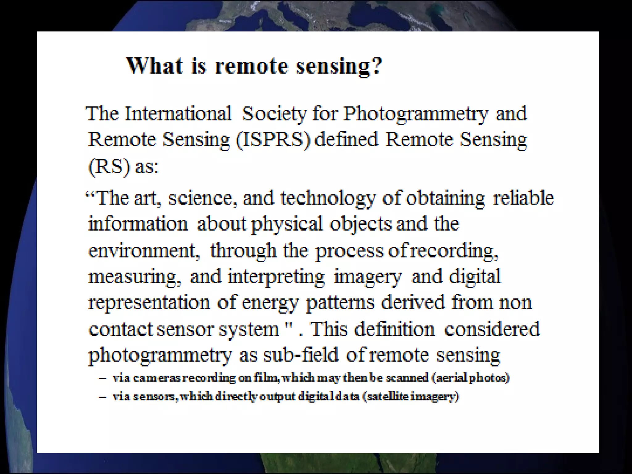
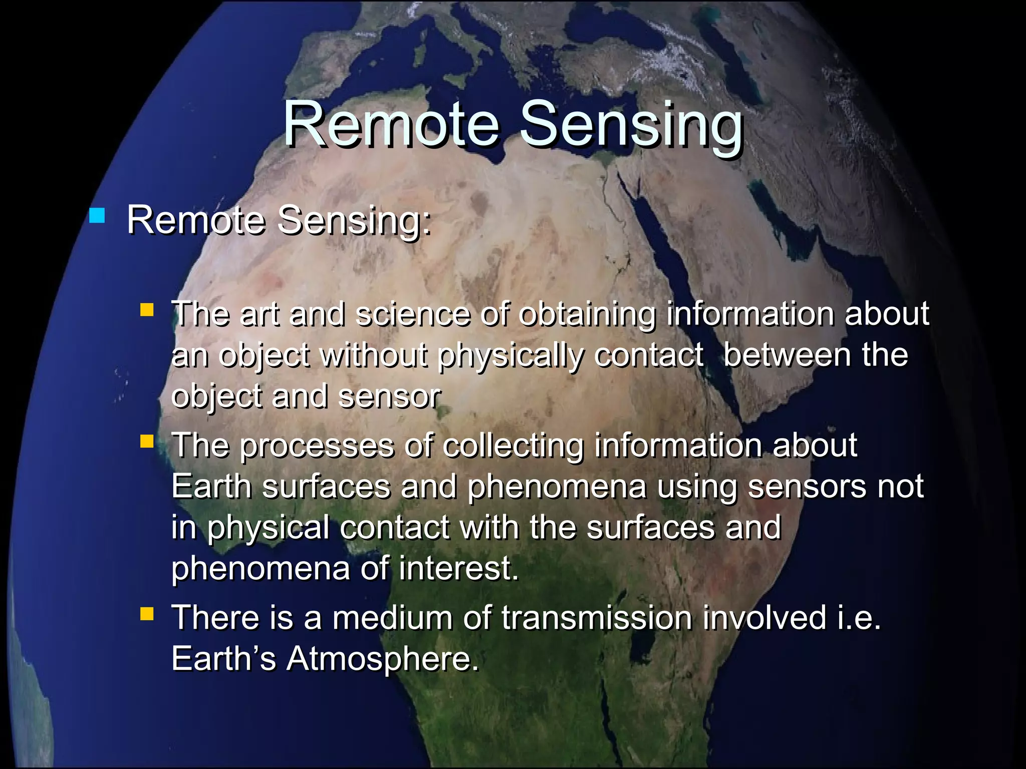
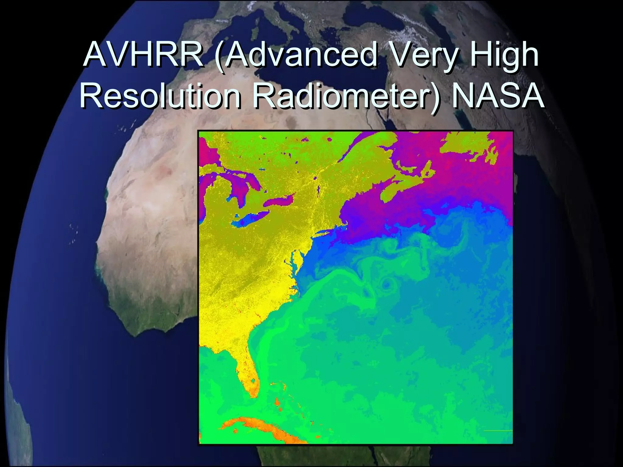
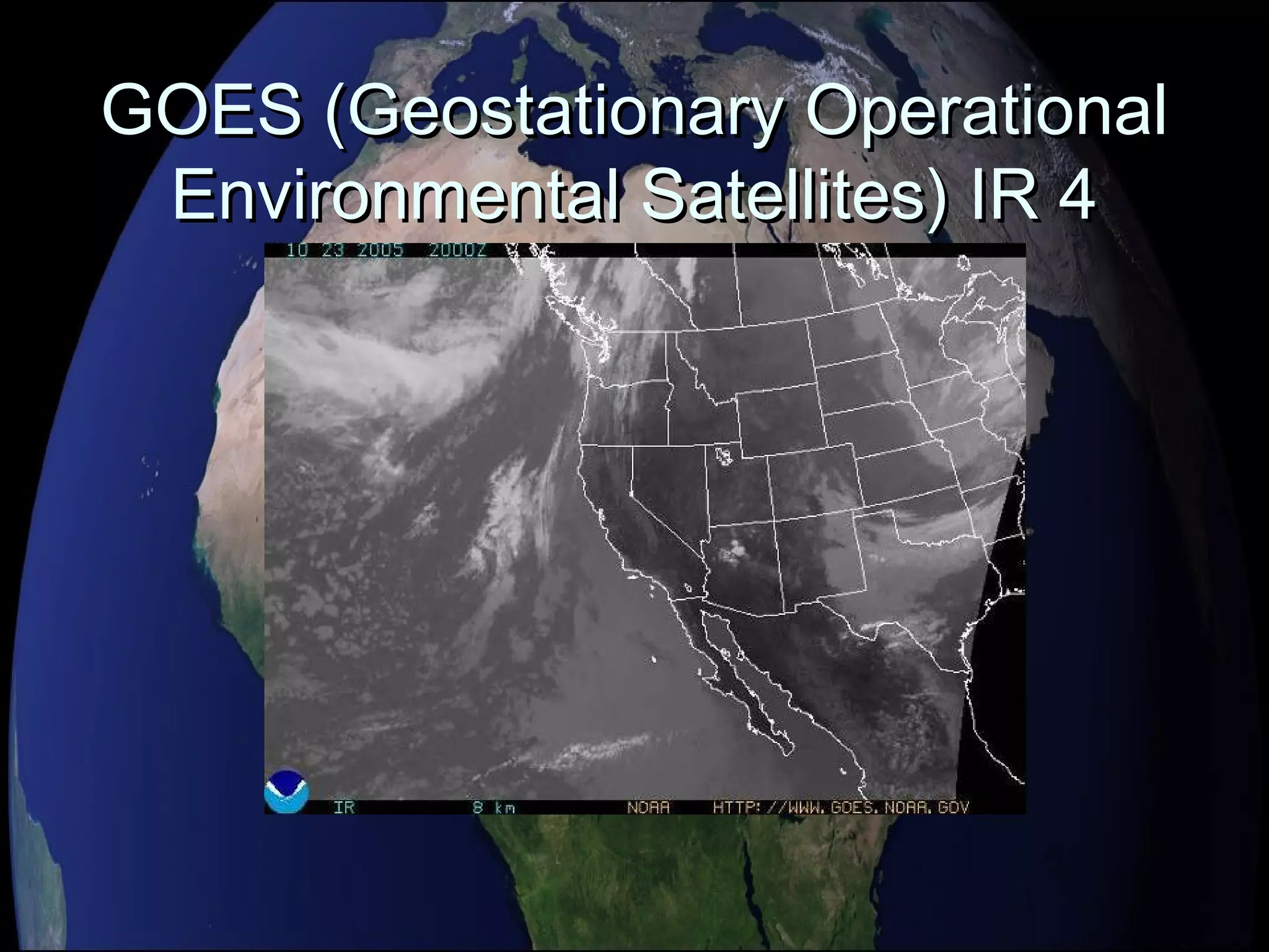
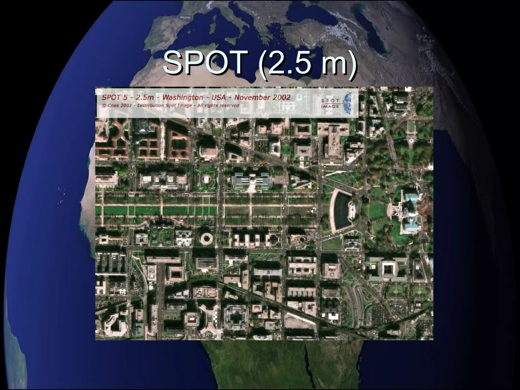
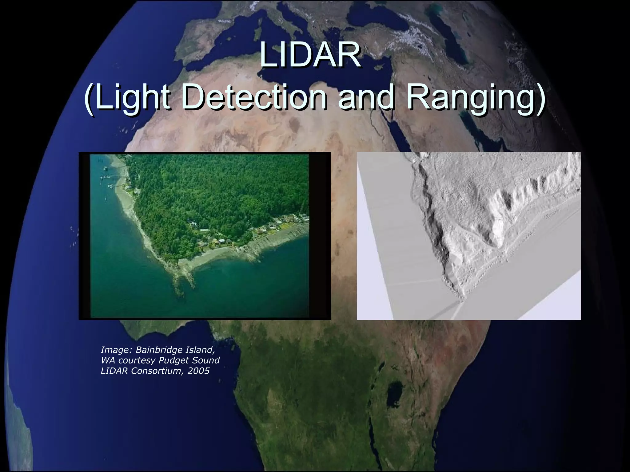
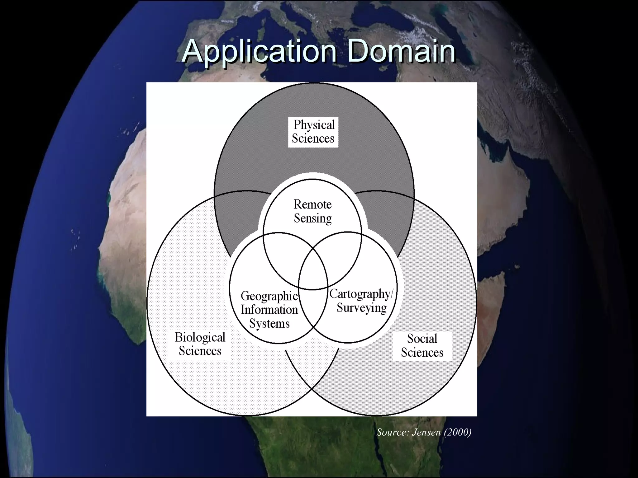
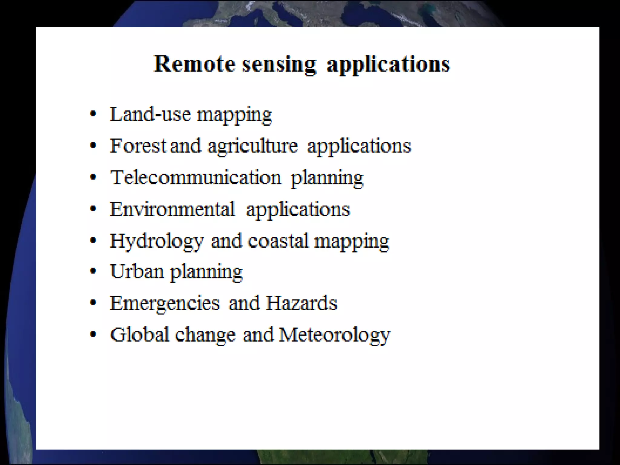
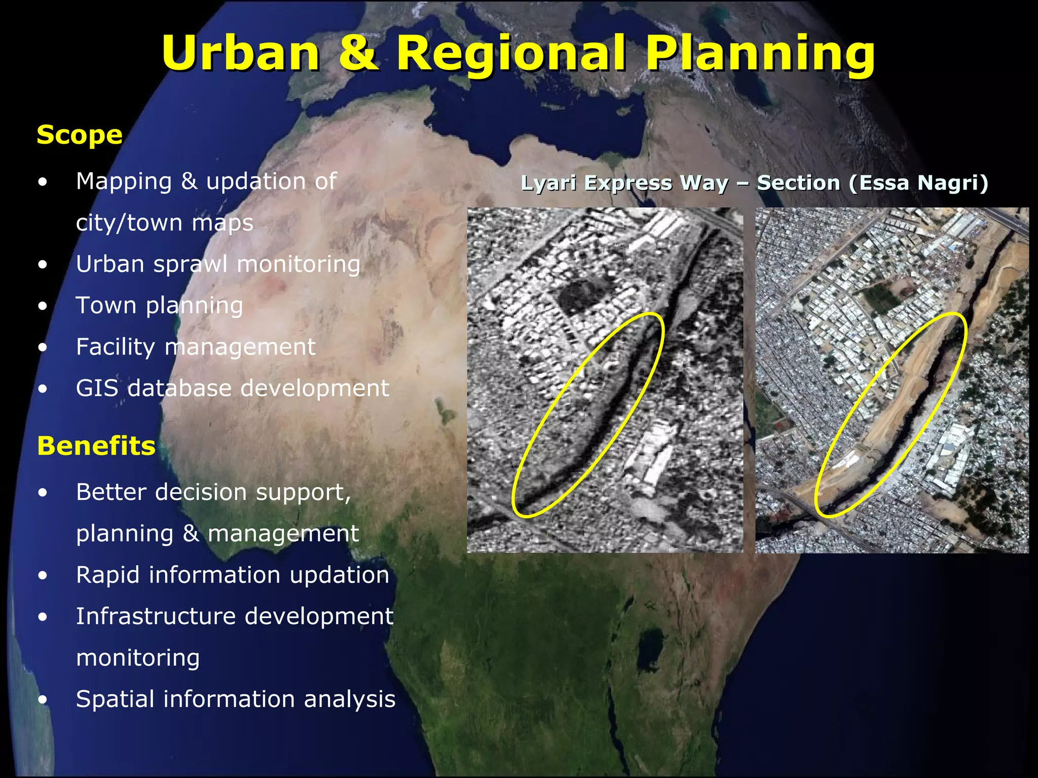
Remote SensingRemote Sensing
&&
ApplicationsApplications
Dr. Muhammad BasharatDr. Muhammad Basharat
Remote SensingRemote Sensing
 Remote Sensing:Remote Sensing:
 The art and science of obtaining information aboutThe art and science of obtaining information about
an object without physically contact between thean object without physically contact between the
object and sensorobject and sensor
 The processes of collecting information aboutThe processes of collecting information about
Earth surfaces and phenomena using sensors notEarth surfaces and phenomena using sensors not
in physical contact with the surfaces andin physical contact with the surfaces and
phenomena of interest.phenomena of interest.
 There is a medium of transmission involved i.e.There is a medium of transmission involved i.e.
Earth’s Atmosphere.Earth’s Atmosphere.
History of RemoteHistory of Remote
SensingSensing
 Balloon photographyBalloon photography
(1858)(1858)
 Pigeon camerasPigeon cameras
(1903)(1903)
 Kite photographyKite photography
(1890)(1890)
 Aircraft (WWI andAircraft (WWI and
WWII)WWII)
 Space (1947)Space (1947)
Images: Jensen (2000)
Remote sensing literature-Remote sensing literature-
JJournal/Conferencesournal/Conferences
 Photogrammetric Engineering andPhotogrammetric Engineering and
Remote sensing (PE & RS)Remote sensing (PE & RS)
 Photogrammetric RecordPhotogrammetric Record
 International Journal of RemoteInternational Journal of Remote
SensingSensing
 ISPRS Journal of Photogrammetry andISPRS Journal of Photogrammetry and
Remote SensingRemote Sensing
 ISPRS conference proceedingsISPRS conference proceedings
 IGARSS conference proceedingsIGARSS conference proceedings
Remote sensing literature -BRemote sensing literature -Booksooks
 Askne, J. (1995).Askne, J. (1995). Sensors andSensors and
Environmental applications of remoteEnvironmental applications of remote
sensingsensing, Balkema, Rotterdam, NL, Balkema, Rotterdam, NL
 Campbell, J. B. , 1996.Campbell, J. B. , 1996. Introduction toIntroduction to
Remote SensingRemote Sensing . 2. 2ndnd
ed.,Taylor and Francis,ed.,Taylor and Francis,
LondonLondon
 Dengre, J. (1994).Dengre, J. (1994). Thematic Mapping fromThematic Mapping from
satellite imagerysatellite imagery : Guide book, Elsevier ltd,: Guide book, Elsevier ltd,
BoulevardBoulevard
 Lillesand, T. M. and R. W. Kiefer, 2000.Lillesand, T. M. and R. W. Kiefer, 2000.
Remote Sensing and ImageRemote Sensing and Image
Interpretation.Interpretation. 44thth
ed., John Wiley and Sons,ed., John Wiley and Sons,
Inc. New YorkInc. New York
 Simonette, D. S. (ed) (1983)Simonette, D. S. (ed) (1983) Manual ofManual of
OutlineOutline
 Some basic concept of Remote SensingSome basic concept of Remote Sensing
 Electromagnetic Radiations (Energy)Electromagnetic Radiations (Energy)
(EMR)(EMR)
 ResolutionResolution
 TypesTypes
 ApplicationsApplications
Remote sensing cycleRemote sensing cycle
 Remote Sensing Includes:Remote Sensing Includes:
 A) The mission plan and choice of sensorsA) The mission plan and choice of sensors
 B) The reception, recording, and processing of theB) The reception, recording, and processing of the
signal datasignal data
 C) The analysis of the resultant data.C) The analysis of the resultant data.
Energy Source or Illumination (A)
Radiation and the Atmosphere (B)
Interaction with the Target (C)
Recording of Energy by the Sensor (D)
Transmission, Reception, and
Processing (E)
Interpretation and Analysis (F)
Application (G)
Source: Canadian Centre for Remote Sensing
Remote Sensing Process Components
Electromagnetic SpectrumElectromagnetic Spectrum
Electromagnetic RadiationElectromagnetic Radiation
Signature SpectraSignature Spectra
Fundamental termFundamental term
 AllAll remote sensing systems haveremote sensing systems have four typesfour types ofof
resolution:resolution:
 SpatialSpatial
 SpectralSpectral
 TemporalTemporal
 RadiometricRadiometric
ResolutionResolution
Spatial ResolutionSpatial Resolution
 The earth surface area covered by a pixelThe earth surface area covered by a pixel
of an image is known as spatial resolutionof an image is known as spatial resolution
 Large area covered by a pixel means lowLarge area covered by a pixel means low
spatial resolution and vice versaspatial resolution and vice versa
High vs. Low?
Spatial Resolution
Source: Jensen (2000)
Spectral ResolutionSpectral Resolution
 Is the ability to resolve spectral featuresIs the ability to resolve spectral features
and bands into their separate componentsand bands into their separate components
 More number of bands in a specifiedMore number of bands in a specified
bandwidth means higher spectralbandwidth means higher spectral
resolution and vice versaresolution and vice versa
Temporal ResolutionTemporal Resolution
 Frequency at which images are recorded/Frequency at which images are recorded/
captured in a specific place on the earth.captured in a specific place on the earth.
 The more frequently it is captured, the better orThe more frequently it is captured, the better or
finer the temporal resolution is said to befiner the temporal resolution is said to be
 For example, a sensor that captures an image ofFor example, a sensor that captures an image of
an agriculture land twice a day has betteran agriculture land twice a day has better
temporal resolution than a sensor that onlytemporal resolution than a sensor that only
captures that same image once a week.captures that same image once a week.
Temporal ResolutionTemporal Resolution
Time
July 1 July 12 July 23 August 3
11 days
16 days
July 2 July 18 August 3
Radiometric ResolutionRadiometric Resolution
 Sensitivity of the sensor to the magnitudeSensitivity of the sensor to the magnitude
of the received electromagnetic energyof the received electromagnetic energy
determines the radiometric resolutiondetermines the radiometric resolution
 Finer the radiometric resolution of aFiner the radiometric resolution of a
sensor, if it is more sensitive in detectingsensor, if it is more sensitive in detecting
small differences in reflected or emittedsmall differences in reflected or emitted
energyenergy
Radiometric ResolutionRadiometric Resolution
1023
6-bit range
0 63
8-bit range
0 255
0
10-bit range
2-bit range
0 4
Types of Remote SensingTypes of Remote Sensing
 Aerial PhotographyAerial Photography
 MultispectralMultispectral
 Active and Passive Microwave and LIDARActive and Passive Microwave and LIDAR
Some known satellitesSome known satellites
 NOAA-AVHRR (1100 m)NOAA-AVHRR (1100 m)
 GOES (700 m)GOES (700 m)
 MODIS (250, 500, 1000 m)MODIS (250, 500, 1000 m)
 Landsat TM and ETM (30 – 60 m)Landsat TM and ETM (30 – 60 m)
 SPOT (10 – 20 m)SPOT (10 – 20 m)
 IKONOS (4, 1 m)IKONOS (4, 1 m)
 Quickbird (0.6 m)Quickbird (0.6 m)
AVHRR (Advanced Very HighAVHRR (Advanced Very High
Resolution Radiometer) NASAResolution Radiometer) NASA
GOES (Geostationary OperationalGOES (Geostationary Operational
Environmental Satellites) IR 4Environmental Satellites) IR 4
MODIS (250 m)MODIS (250 m)
Landsat TMLandsat TM
(False Color Composite)(False Color Composite)
SPOT (2.5 m)SPOT (2.5 m)
QUICKBIRD (0.6 m)QUICKBIRD (0.6 m)
IKONOS (4 m Multispectral)IKONOS (4 m Multispectral)
IKONOS (1 m Panchromatic)IKONOS (1 m Panchromatic)
RADARRADAR
(Radio Detection and Ranging)(Radio Detection and Ranging)
Image: NASA 2005
LIDARLIDAR
(Light Detection and Ranging)(Light Detection and Ranging)
Image: Bainbridge Island,
WA courtesy Pudget Sound
LIDAR Consortium, 2005
Applications of Remote SensingApplications of Remote Sensing
Source: Jensen (2000)
Application DomainApplication Domain
Urban & Regional PlanningUrban & Regional Planning
• Mapping & updation of
city/town maps
• Urban sprawl monitoring
• Town planning
• Facility management
• GIS database development
Scope
Lyari Express Way – Section (Essa Nagri)Lyari Express Way – Section (Essa Nagri)
• Better decision support,
planning & management
• Rapid information updation
• Infrastructure development
monitoring
• Spatial information analysis
Benefits
AgricultureAgriculture
• Crop acreage estimation
• Crop modeling for yield &
production forecast / estimation
• Crop & Orchard monitoring
Scope
• Timely availability of crop
statistics for decision making &
planning
• Crop growth monitoring
• Soil status monitoring
• Regular reports regarding total
area under cultivation
Benefits
Banana Plantation – Muhammad Pur (Ghotki)Banana Plantation – Muhammad Pur (Ghotki)
FFC Goth MacchiFFC Goth Macchi
Mar 05, 2006, RecoveryJan 12, 2006, DamageDec 16, 2005, Pre-Frost
Pre Flood – 17 July 2006 Post Flood – 09 Aug 2006
10098 acr
3516 acr
● Phulani
● Goth Lataran
● Ural
● Junno Dhand
● Shahpur
● Godhpur
● Than Lake
● Goth Azizpur
● Goth Raza Mahar
● Phulani
● Goth Lataran
● Ural
● Junno Dhand
● Shahpur
● Godhpur
● Than Lake
● Goth Azizpur
● Goth Raza Mahar
● Muhro Mari
● Darapur
● Kot Shahgarch
● Muhro Mari
● Darapur
● Kot Shahgarch
Flood Damage to Standing CropsFlood Damage to Standing Crops
Sukkur
ForestryForestry
• Satellite image based forest
resource mapping and updation
• Forest change detection
• Forest resource inventory
• GIS database development
Scope
• Availability of baseline
information
• Planning for aforestation
strategies
• Futuristic resource planning
• Sustainability of environment
• Wild life conservation & development
for recreation purpose
Benefits Sarhad Reserve Forest (Ghotki)
Nausharo
Firoz
Sindh Coast Resource MappingSindh Coast Resource Mapping
Satellite image Mangroves forest map
• Mangrove forest monitoring
• Change detection
• Hazard impacts
• Aqua-culture zones
Scope
Benefits
• Availability of updated
information on mangroves
forest
• Planning strategies for
aforestation and deforestation
trend
• Timely Intervention in specific
areas as and when needed
Landuse / Landcover MappingLanduse / Landcover Mapping
• Monitoring dynamic changes
• Urban/Rural infrastructure
• Waterlogging & salinity
Scope
• Assessment of spatial distribution
of land resources
• Infrastructure monitoring
• Availability of usable land
• Future planning for better land
management for socio-economic
development
Benefits
Infrastructure DevelopmentInfrastructure Development
Larkana-Khairpur Bridge
Thanks for patienceThanks for patience

Remote Sensing

  • 1.
  • 4.
    Remote SensingRemote Sensing Remote Sensing:Remote Sensing:  The art and science of obtaining information aboutThe art and science of obtaining information about an object without physically contact between thean object without physically contact between the object and sensorobject and sensor  The processes of collecting information aboutThe processes of collecting information about Earth surfaces and phenomena using sensors notEarth surfaces and phenomena using sensors not in physical contact with the surfaces andin physical contact with the surfaces and phenomena of interest.phenomena of interest.  There is a medium of transmission involved i.e.There is a medium of transmission involved i.e. Earth’s Atmosphere.Earth’s Atmosphere.
  • 5.
    History of RemoteHistoryof Remote SensingSensing  Balloon photographyBalloon photography (1858)(1858)  Pigeon camerasPigeon cameras (1903)(1903)  Kite photographyKite photography (1890)(1890)  Aircraft (WWI andAircraft (WWI and WWII)WWII)  Space (1947)Space (1947) Images: Jensen (2000)
  • 7.
    Remote sensing literature-Remotesensing literature- JJournal/Conferencesournal/Conferences  Photogrammetric Engineering andPhotogrammetric Engineering and Remote sensing (PE & RS)Remote sensing (PE & RS)  Photogrammetric RecordPhotogrammetric Record  International Journal of RemoteInternational Journal of Remote SensingSensing  ISPRS Journal of Photogrammetry andISPRS Journal of Photogrammetry and Remote SensingRemote Sensing  ISPRS conference proceedingsISPRS conference proceedings  IGARSS conference proceedingsIGARSS conference proceedings
  • 8.
    Remote sensing literature-BRemote sensing literature -Booksooks  Askne, J. (1995).Askne, J. (1995). Sensors andSensors and Environmental applications of remoteEnvironmental applications of remote sensingsensing, Balkema, Rotterdam, NL, Balkema, Rotterdam, NL  Campbell, J. B. , 1996.Campbell, J. B. , 1996. Introduction toIntroduction to Remote SensingRemote Sensing . 2. 2ndnd ed.,Taylor and Francis,ed.,Taylor and Francis, LondonLondon  Dengre, J. (1994).Dengre, J. (1994). Thematic Mapping fromThematic Mapping from satellite imagerysatellite imagery : Guide book, Elsevier ltd,: Guide book, Elsevier ltd, BoulevardBoulevard  Lillesand, T. M. and R. W. Kiefer, 2000.Lillesand, T. M. and R. W. Kiefer, 2000. Remote Sensing and ImageRemote Sensing and Image Interpretation.Interpretation. 44thth ed., John Wiley and Sons,ed., John Wiley and Sons, Inc. New YorkInc. New York  Simonette, D. S. (ed) (1983)Simonette, D. S. (ed) (1983) Manual ofManual of
  • 10.
    OutlineOutline  Some basicconcept of Remote SensingSome basic concept of Remote Sensing  Electromagnetic Radiations (Energy)Electromagnetic Radiations (Energy) (EMR)(EMR)  ResolutionResolution  TypesTypes  ApplicationsApplications
  • 12.
    Remote sensing cycleRemotesensing cycle  Remote Sensing Includes:Remote Sensing Includes:  A) The mission plan and choice of sensorsA) The mission plan and choice of sensors  B) The reception, recording, and processing of theB) The reception, recording, and processing of the signal datasignal data  C) The analysis of the resultant data.C) The analysis of the resultant data.
  • 13.
    Energy Source orIllumination (A) Radiation and the Atmosphere (B) Interaction with the Target (C) Recording of Energy by the Sensor (D) Transmission, Reception, and Processing (E) Interpretation and Analysis (F) Application (G) Source: Canadian Centre for Remote Sensing Remote Sensing Process Components
  • 14.
  • 15.
  • 16.
  • 17.
    Fundamental termFundamental term AllAll remote sensing systems haveremote sensing systems have four typesfour types ofof resolution:resolution:  SpatialSpatial  SpectralSpectral  TemporalTemporal  RadiometricRadiometric ResolutionResolution
  • 18.
    Spatial ResolutionSpatial Resolution The earth surface area covered by a pixelThe earth surface area covered by a pixel of an image is known as spatial resolutionof an image is known as spatial resolution  Large area covered by a pixel means lowLarge area covered by a pixel means low spatial resolution and vice versaspatial resolution and vice versa
  • 19.
    High vs. Low? SpatialResolution Source: Jensen (2000)
  • 20.
    Spectral ResolutionSpectral Resolution Is the ability to resolve spectral featuresIs the ability to resolve spectral features and bands into their separate componentsand bands into their separate components  More number of bands in a specifiedMore number of bands in a specified bandwidth means higher spectralbandwidth means higher spectral resolution and vice versaresolution and vice versa
  • 21.
    Temporal ResolutionTemporal Resolution Frequency at which images are recorded/Frequency at which images are recorded/ captured in a specific place on the earth.captured in a specific place on the earth.  The more frequently it is captured, the better orThe more frequently it is captured, the better or finer the temporal resolution is said to befiner the temporal resolution is said to be  For example, a sensor that captures an image ofFor example, a sensor that captures an image of an agriculture land twice a day has betteran agriculture land twice a day has better temporal resolution than a sensor that onlytemporal resolution than a sensor that only captures that same image once a week.captures that same image once a week.
  • 22.
    Temporal ResolutionTemporal Resolution Time July1 July 12 July 23 August 3 11 days 16 days July 2 July 18 August 3
  • 23.
    Radiometric ResolutionRadiometric Resolution Sensitivity of the sensor to the magnitudeSensitivity of the sensor to the magnitude of the received electromagnetic energyof the received electromagnetic energy determines the radiometric resolutiondetermines the radiometric resolution  Finer the radiometric resolution of aFiner the radiometric resolution of a sensor, if it is more sensitive in detectingsensor, if it is more sensitive in detecting small differences in reflected or emittedsmall differences in reflected or emitted energyenergy
  • 24.
    Radiometric ResolutionRadiometric Resolution 1023 6-bitrange 0 63 8-bit range 0 255 0 10-bit range 2-bit range 0 4
  • 25.
    Types of RemoteSensingTypes of Remote Sensing  Aerial PhotographyAerial Photography  MultispectralMultispectral  Active and Passive Microwave and LIDARActive and Passive Microwave and LIDAR
  • 26.
    Some known satellitesSomeknown satellites  NOAA-AVHRR (1100 m)NOAA-AVHRR (1100 m)  GOES (700 m)GOES (700 m)  MODIS (250, 500, 1000 m)MODIS (250, 500, 1000 m)  Landsat TM and ETM (30 – 60 m)Landsat TM and ETM (30 – 60 m)  SPOT (10 – 20 m)SPOT (10 – 20 m)  IKONOS (4, 1 m)IKONOS (4, 1 m)  Quickbird (0.6 m)Quickbird (0.6 m)
  • 27.
    AVHRR (Advanced VeryHighAVHRR (Advanced Very High Resolution Radiometer) NASAResolution Radiometer) NASA
  • 28.
    GOES (Geostationary OperationalGOES(Geostationary Operational Environmental Satellites) IR 4Environmental Satellites) IR 4
  • 29.
  • 30.
    Landsat TMLandsat TM (FalseColor Composite)(False Color Composite)
  • 31.
  • 32.
  • 33.
    IKONOS (4 mMultispectral)IKONOS (4 m Multispectral)
  • 34.
    IKONOS (1 mPanchromatic)IKONOS (1 m Panchromatic)
  • 35.
    RADARRADAR (Radio Detection andRanging)(Radio Detection and Ranging) Image: NASA 2005
  • 36.
    LIDARLIDAR (Light Detection andRanging)(Light Detection and Ranging) Image: Bainbridge Island, WA courtesy Pudget Sound LIDAR Consortium, 2005
  • 37.
    Applications of RemoteSensingApplications of Remote Sensing
  • 38.
    Source: Jensen (2000) ApplicationDomainApplication Domain
  • 41.
    Urban & RegionalPlanningUrban & Regional Planning • Mapping & updation of city/town maps • Urban sprawl monitoring • Town planning • Facility management • GIS database development Scope Lyari Express Way – Section (Essa Nagri)Lyari Express Way – Section (Essa Nagri) • Better decision support, planning & management • Rapid information updation • Infrastructure development monitoring • Spatial information analysis Benefits
  • 42.
    AgricultureAgriculture • Crop acreageestimation • Crop modeling for yield & production forecast / estimation • Crop & Orchard monitoring Scope • Timely availability of crop statistics for decision making & planning • Crop growth monitoring • Soil status monitoring • Regular reports regarding total area under cultivation Benefits Banana Plantation – Muhammad Pur (Ghotki)Banana Plantation – Muhammad Pur (Ghotki) FFC Goth MacchiFFC Goth Macchi Mar 05, 2006, RecoveryJan 12, 2006, DamageDec 16, 2005, Pre-Frost
  • 43.
    Pre Flood –17 July 2006 Post Flood – 09 Aug 2006 10098 acr 3516 acr ● Phulani ● Goth Lataran ● Ural ● Junno Dhand ● Shahpur ● Godhpur ● Than Lake ● Goth Azizpur ● Goth Raza Mahar ● Phulani ● Goth Lataran ● Ural ● Junno Dhand ● Shahpur ● Godhpur ● Than Lake ● Goth Azizpur ● Goth Raza Mahar ● Muhro Mari ● Darapur ● Kot Shahgarch ● Muhro Mari ● Darapur ● Kot Shahgarch Flood Damage to Standing CropsFlood Damage to Standing Crops Sukkur
  • 44.
    ForestryForestry • Satellite imagebased forest resource mapping and updation • Forest change detection • Forest resource inventory • GIS database development Scope • Availability of baseline information • Planning for aforestation strategies • Futuristic resource planning • Sustainability of environment • Wild life conservation & development for recreation purpose Benefits Sarhad Reserve Forest (Ghotki) Nausharo Firoz
  • 45.
    Sindh Coast ResourceMappingSindh Coast Resource Mapping Satellite image Mangroves forest map • Mangrove forest monitoring • Change detection • Hazard impacts • Aqua-culture zones Scope Benefits • Availability of updated information on mangroves forest • Planning strategies for aforestation and deforestation trend • Timely Intervention in specific areas as and when needed
  • 46.
    Landuse / LandcoverMappingLanduse / Landcover Mapping • Monitoring dynamic changes • Urban/Rural infrastructure • Waterlogging & salinity Scope • Assessment of spatial distribution of land resources • Infrastructure monitoring • Availability of usable land • Future planning for better land management for socio-economic development Benefits
  • 47.
  • 48.

Editor's Notes

  • #30 October 23, 2005 Dust storm in Chad at 250 m resolution, MODIS (Moderate Resolution Imaging Spectroradiometer) NASA Moderate Resolution Imaging Spectrometer, 705 km, sun-synchronous orbit, 1-2 day for all of earth, 250 m, 500 m, 1000 m resolution. NASA
  • #31 30 m resolution and 60 m resolution (thermal), 705 km orbit, 7 bands including thermal infrared, Manhattan, KS. Image, 2000 (USGS-EROS)