SlideShare a Scribd company logo
1 of 22
REMOTE SENSING - FUNDAMENTALS
Dr. Ajay Singh Lodhi
Assistant Professor
College of Agriculture, Balaghat
Jawahar Lal Krishi Vishwa Vidyalaya, Jabalpur (M.P.)
REMOTE SENSING SENSORS
 Passive sensors: Passive
system record energy reflected or
emitted by a target illuminated by
sun.
 e.g. normal photography, most
optical satellite sensors.
 Active sensors: Active system
illuminates target with energy and
measure reflection.
 e.g. Radar sensors,
Passive Remote Sensing
 Doesn’t employ any external source of energy.
 Measures either reflected radiation from Sun (can be
operated only during daytime) or the emitted radiation from
the surface (day/night operation).
 Suffers from variable illumination conditions of Sun and
influence of atmospheric conditions
Active Remote sensing
 Has its own source of energy
 Active sensors emit a controlled beam of energy to the
surface and measure the amount of energy reflected back
to the sensor.
 Controlled illumination signal
 Day/night operation
Passive sensors : collect electromagnetic radiation in the
visible and infra-red part of the spectrum.
 Aerial Photographs
 Low resolution: Landsat,, SPOT, IRS
 High Resolution: Quickbird, IKONOS
Active sensors : generate their own radiation.
 Air-borne RADAR
 Space borne RADAR: ERS 1 / 2, Radarsat
 LiDAR (laser scanner)
FUNDAMENTAL PHYSICS OF REMOTE SENSING
 Remote Sensing relies on the measurement of Electro
Magnetic (EM) energy.
 The most important source of EM energy is the sun Some
sensors detect energy emitted by the Earth itself or provide
their own energy (Radar) .
 All matter reflects, penetrate, observes and emits of EMR
in unique way, which called spectral characteristics
 Two characteristic of electromagnetic radiation are
particularly important for understanding remote sensing.
These are the wavelength and frequency.
 The wave length is the length of one
wave cycle which can be measured
as the distance between successive
Wave crests.
 Wave length is usually represented
by the lambda wave length is
measured in meter (M) or some
factors of meters such as
nanometers (nm) micrometers(um) ,
centimeters (cm)
 Frequency refers to the number of
cycles of waves passing a fixed point
per unit of time. Frequency is
normally measured in hertz (Hz),
equivalent to one cycle per second
and various multiples of hertz.
 Relation between Wavelength and Frequency: Wavelength
and frequency are related by the following formula:
𝐶 = 𝜆𝑣
Where
𝜆 = Wavelength (m)
𝑣= frequency (cycles per second, Hz)
c = speed of light (3x10⁸ m/s)
Therefore, the two are inversely related to each other. The
shorter the wave length, the higher the frequency. The longer
the wave length, the lower frequency
 Electro-magnetic spectrum (EMS) is an array of all EMR,
which moves velocity of light, characteristic of wavelength
and frequency of energy.
 The electromagnetic spectrum ranges from the shorter
wavelengths (including gamma and x-rays) to the longer
wavelengths (including microwaves and broadcast radio
waves)
 There are several regions of the electromagnetic spectrum
which are useful for remote sensing.
Electromagnetic Spectrum (EMS)
Ultraviolet Range
 This radiation is just beyond the violet portion of the visible
wavelengths
 Some Earth surface materials, primarily rocks and minerals,
emit visible light when illuminated by UV radiation.
Visible Range
 The light which our eyes - our "remote sensors" can detect
is part of the visible spectrum.
 The visible wavelengths cover a range from approximately
0.4 to 0.7 µm. The longest visible wavelength is red and the
shortest is violet .This is the only portion of the spectrum we
can associate with the concept of colours.
REMOTE SENSING OBSERVATION PLATFORM
 Sensor-the device that actually gathers the remotely
sensed data
 Platform-the device to which the sensor is attached
 The vehicles or carriers for remote sensing are called the
platform.
 Based on its altitude above earth surface typically platform
are satellite and aircraft but they can also, aero plane,
balloons, kites. platform may be classified as,
1) Ground borne
2) Air borne
3) Space borne
 Air born and space born
platform have been in use in
remote sensing of earth
resources.
 The ground based remote
sensing system for earth
resources studies are
mainly used for collecting
the ground truth or for
laboratory simulation
studies.
Thank You

More Related Content

What's hot

Remote sensing
Remote sensingRemote sensing
Remote sensingKU Leuven
 
Remote Sensing Platforms and Its types
Remote Sensing Platforms and Its typesRemote Sensing Platforms and Its types
Remote Sensing Platforms and Its typesSenthamizhan M
 
Fundamentals of Remote Sensing
Fundamentals of Remote Sensing Fundamentals of Remote Sensing
Fundamentals of Remote Sensing Pallab Jana
 
Microwave remote sensing
Microwave remote sensingMicrowave remote sensing
Microwave remote sensingRohit Kumar
 
A Brief Introduction to Remote Sensing Satellites
A Brief Introduction to Remote Sensing Satellites A Brief Introduction to Remote Sensing Satellites
A Brief Introduction to Remote Sensing Satellites Alireza Rahimzadeganasl
 
Energy interaction with earth surface features
Energy interaction with earth surface featuresEnergy interaction with earth surface features
Energy interaction with earth surface featuressuchismita11
 
Basics of remote sensing, pk mani
Basics of remote sensing, pk maniBasics of remote sensing, pk mani
Basics of remote sensing, pk maniP.K. Mani
 
Introduction to Landsat
Introduction to LandsatIntroduction to Landsat
Introduction to LandsatNizam GIS
 
Remote sensing concept, history and principles
Remote sensing  concept, history and principlesRemote sensing  concept, history and principles
Remote sensing concept, history and principlesAjay Singh Lodhi
 
Aerial photography.pptx
Aerial photography.pptxAerial photography.pptx
Aerial photography.pptxPramoda Raj
 
Spectral reflectance curve of dead stressed vegetation
Spectral reflectance curve of dead stressed vegetationSpectral reflectance curve of dead stressed vegetation
Spectral reflectance curve of dead stressed vegetationJunaid Ijaz
 
Types of aerial photographs
Types of aerial photographsTypes of aerial photographs
Types of aerial photographsHARITHANAIR15
 
Platforms of Remote sensing and GIS
Platforms of Remote sensing and GISPlatforms of Remote sensing and GIS
Platforms of Remote sensing and GISMouna Guru
 
Ppt on remote sensing system
Ppt on remote sensing systemPpt on remote sensing system
Ppt on remote sensing systemAlisha Korpal
 
Sensors for remote sensing
Sensors for remote sensingSensors for remote sensing
Sensors for remote sensingMohsin Siddique
 

What's hot (20)

Remote sensing
Remote sensingRemote sensing
Remote sensing
 
Remote sensing
Remote sensingRemote sensing
Remote sensing
 
Introduction to Remote Sensing
Introduction to Remote SensingIntroduction to Remote Sensing
Introduction to Remote Sensing
 
Remote Sensing Platforms and Its types
Remote Sensing Platforms and Its typesRemote Sensing Platforms and Its types
Remote Sensing Platforms and Its types
 
Fundamentals of Remote Sensing
Fundamentals of Remote Sensing Fundamentals of Remote Sensing
Fundamentals of Remote Sensing
 
Microwave remote sensing
Microwave remote sensingMicrowave remote sensing
Microwave remote sensing
 
A Brief Introduction to Remote Sensing Satellites
A Brief Introduction to Remote Sensing Satellites A Brief Introduction to Remote Sensing Satellites
A Brief Introduction to Remote Sensing Satellites
 
Energy interaction with earth surface features
Energy interaction with earth surface featuresEnergy interaction with earth surface features
Energy interaction with earth surface features
 
LISS
LISSLISS
LISS
 
Basics of remote sensing, pk mani
Basics of remote sensing, pk maniBasics of remote sensing, pk mani
Basics of remote sensing, pk mani
 
Introduction to Landsat
Introduction to LandsatIntroduction to Landsat
Introduction to Landsat
 
Remote sensing concept, history and principles
Remote sensing  concept, history and principlesRemote sensing  concept, history and principles
Remote sensing concept, history and principles
 
Aerial photography.pptx
Aerial photography.pptxAerial photography.pptx
Aerial photography.pptx
 
Spectral reflectance curve of dead stressed vegetation
Spectral reflectance curve of dead stressed vegetationSpectral reflectance curve of dead stressed vegetation
Spectral reflectance curve of dead stressed vegetation
 
remote sensing
remote sensingremote sensing
remote sensing
 
Types of aerial photographs
Types of aerial photographsTypes of aerial photographs
Types of aerial photographs
 
Remote sensing
Remote sensingRemote sensing
Remote sensing
 
Platforms of Remote sensing and GIS
Platforms of Remote sensing and GISPlatforms of Remote sensing and GIS
Platforms of Remote sensing and GIS
 
Ppt on remote sensing system
Ppt on remote sensing systemPpt on remote sensing system
Ppt on remote sensing system
 
Sensors for remote sensing
Sensors for remote sensingSensors for remote sensing
Sensors for remote sensing
 

Similar to Remote Sensing - Fundamentals

Introduction to Remote Sensing- by Wankie Richman
Introduction to Remote Sensing- by Wankie RichmanIntroduction to Remote Sensing- by Wankie Richman
Introduction to Remote Sensing- by Wankie RichmanRichmanWankie
 
.remote sensing.Ece 402 unit-2
.remote sensing.Ece 402 unit-2.remote sensing.Ece 402 unit-2
.remote sensing.Ece 402 unit-2Vandana Verma
 
Unit iv remote sensing
Unit iv remote sensingUnit iv remote sensing
Unit iv remote sensingSharad Ladumor
 
Forestry rs introduction 2021
Forestry  rs introduction  2021Forestry  rs introduction  2021
Forestry rs introduction 2021Devesh Walia
 
detail information of advance total station and remote sensing
detail information of advance total station and remote sensingdetail information of advance total station and remote sensing
detail information of advance total station and remote sensingshaikh imran
 
Surveying ii ajith sir class1
Surveying ii ajith sir class1Surveying ii ajith sir class1
Surveying ii ajith sir class1SHAMJITH KM
 
Introduction to remote sensing pt 1
Introduction to remote sensing pt 1Introduction to remote sensing pt 1
Introduction to remote sensing pt 1TafadzwaMarione
 
Basic of Remote Sensing
Basic of Remote SensingBasic of Remote Sensing
Basic of Remote Sensinggueste5cfed
 
Principles of Remote Sensing
Principles of Remote Sensing Principles of Remote Sensing
Principles of Remote Sensing Ariful Islam
 
passive and active remote sensing systems, characteristics and operations
passive and active remote sensing systems,  characteristics and operationspassive and active remote sensing systems,  characteristics and operations
passive and active remote sensing systems, characteristics and operationsNzar Braim
 
Role of electromagnetic Radiation in Remote Sensing
Role of electromagnetic Radiation in  Remote SensingRole of electromagnetic Radiation in  Remote Sensing
Role of electromagnetic Radiation in Remote SensingNzar Braim
 
Basics of remote sensing and GIS.pptx
Basics of remote sensing and GIS.pptxBasics of remote sensing and GIS.pptx
Basics of remote sensing and GIS.pptxFUCKAGAIN
 

Similar to Remote Sensing - Fundamentals (20)

Introduction to Remote Sensing- by Wankie Richman
Introduction to Remote Sensing- by Wankie RichmanIntroduction to Remote Sensing- by Wankie Richman
Introduction to Remote Sensing- by Wankie Richman
 
.remote sensing.Ece 402 unit-2
.remote sensing.Ece 402 unit-2.remote sensing.Ece 402 unit-2
.remote sensing.Ece 402 unit-2
 
remote sensing-converted.pptx
remote sensing-converted.pptxremote sensing-converted.pptx
remote sensing-converted.pptx
 
Unit iv remote sensing
Unit iv remote sensingUnit iv remote sensing
Unit iv remote sensing
 
Forestry rs introduction 2021
Forestry  rs introduction  2021Forestry  rs introduction  2021
Forestry rs introduction 2021
 
detail information of advance total station and remote sensing
detail information of advance total station and remote sensingdetail information of advance total station and remote sensing
detail information of advance total station and remote sensing
 
Surveying ii ajith sir class1
Surveying ii ajith sir class1Surveying ii ajith sir class1
Surveying ii ajith sir class1
 
Introduction to remote sensing pt 1
Introduction to remote sensing pt 1Introduction to remote sensing pt 1
Introduction to remote sensing pt 1
 
Chapter 2 RS.pptx
Chapter 2 RS.pptxChapter 2 RS.pptx
Chapter 2 RS.pptx
 
2 Intro RS.pdf
2 Intro RS.pdf2 Intro RS.pdf
2 Intro RS.pdf
 
Basic of Remote Sensing
Basic of Remote SensingBasic of Remote Sensing
Basic of Remote Sensing
 
Principles of Remote Sensing
Principles of Remote Sensing Principles of Remote Sensing
Principles of Remote Sensing
 
passive and active remote sensing systems, characteristics and operations
passive and active remote sensing systems,  characteristics and operationspassive and active remote sensing systems,  characteristics and operations
passive and active remote sensing systems, characteristics and operations
 
Role of electromagnetic Radiation in Remote Sensing
Role of electromagnetic Radiation in  Remote SensingRole of electromagnetic Radiation in  Remote Sensing
Role of electromagnetic Radiation in Remote Sensing
 
Light
LightLight
Light
 
lec1.pptx
lec1.pptxlec1.pptx
lec1.pptx
 
Basics of remote sensing and GIS.pptx
Basics of remote sensing and GIS.pptxBasics of remote sensing and GIS.pptx
Basics of remote sensing and GIS.pptx
 
EMR and RS.pdf
EMR and RS.pdfEMR and RS.pdf
EMR and RS.pdf
 
Remote sensing
Remote sensingRemote sensing
Remote sensing
 
Remote Sensing
Remote SensingRemote Sensing
Remote Sensing
 

More from Ajay Singh Lodhi

Gully Control Structures.pptx
Gully Control Structures.pptxGully Control Structures.pptx
Gully Control Structures.pptxAjay Singh Lodhi
 
Water Erosion Control Measures for Hilly Areas.pptx
Water Erosion Control Measures for Hilly Areas.pptxWater Erosion Control Measures for Hilly Areas.pptx
Water Erosion Control Measures for Hilly Areas.pptxAjay Singh Lodhi
 
Principles of Soil Erosion.pptx
Principles of Soil Erosion.pptxPrinciples of Soil Erosion.pptx
Principles of Soil Erosion.pptxAjay Singh Lodhi
 
Water Erosion Control Measures- Agricultural Lands.pptx
Water Erosion Control Measures- Agricultural Lands.pptxWater Erosion Control Measures- Agricultural Lands.pptx
Water Erosion Control Measures- Agricultural Lands.pptxAjay Singh Lodhi
 
Universal Soil Loss Equation.pptx
Universal Soil Loss Equation.pptxUniversal Soil Loss Equation.pptx
Universal Soil Loss Equation.pptxAjay Singh Lodhi
 
Soil Loss Measurement Techniques.pptx
Soil Loss Measurement Techniques.pptxSoil Loss Measurement Techniques.pptx
Soil Loss Measurement Techniques.pptxAjay Singh Lodhi
 
Grafting, pruning and training tools.pptx
Grafting, pruning and training tools.pptxGrafting, pruning and training tools.pptx
Grafting, pruning and training tools.pptxAjay Singh Lodhi
 
Harvesting Equipments.pptx
Harvesting Equipments.pptxHarvesting Equipments.pptx
Harvesting Equipments.pptxAjay Singh Lodhi
 
Interculture Equipments.pptx
Interculture Equipments.pptxInterculture Equipments.pptx
Interculture Equipments.pptxAjay Singh Lodhi
 
Sowing and Planting Equipments.pptx
Sowing and Planting Equipments.pptxSowing and Planting Equipments.pptx
Sowing and Planting Equipments.pptxAjay Singh Lodhi
 
Tillage- Secondary Tillage Implements.pptx
Tillage- Secondary Tillage Implements.pptxTillage- Secondary Tillage Implements.pptx
Tillage- Secondary Tillage Implements.pptxAjay Singh Lodhi
 
Tillage and Primary Tillage Implements
Tillage and Primary Tillage ImplementsTillage and Primary Tillage Implements
Tillage and Primary Tillage ImplementsAjay Singh Lodhi
 
Farm Tractor & Power Tiller.pptx
Farm Tractor & Power Tiller.pptxFarm Tractor & Power Tiller.pptx
Farm Tractor & Power Tiller.pptxAjay Singh Lodhi
 
SYSTEMS OF IC ENGINE-Ignition system.pptx
SYSTEMS OF IC ENGINE-Ignition system.pptxSYSTEMS OF IC ENGINE-Ignition system.pptx
SYSTEMS OF IC ENGINE-Ignition system.pptxAjay Singh Lodhi
 
SYSTEMS OF IC ENGINE- Power transmission system.pptx
SYSTEMS OF IC ENGINE- Power transmission system.pptxSYSTEMS OF IC ENGINE- Power transmission system.pptx
SYSTEMS OF IC ENGINE- Power transmission system.pptxAjay Singh Lodhi
 

More from Ajay Singh Lodhi (20)

Wind Erosion.pptx
Wind Erosion.pptxWind Erosion.pptx
Wind Erosion.pptx
 
Water Harvesting.pptx
Water Harvesting.pptxWater Harvesting.pptx
Water Harvesting.pptx
 
Gully Control Structures.pptx
Gully Control Structures.pptxGully Control Structures.pptx
Gully Control Structures.pptx
 
Water Erosion Control Measures for Hilly Areas.pptx
Water Erosion Control Measures for Hilly Areas.pptxWater Erosion Control Measures for Hilly Areas.pptx
Water Erosion Control Measures for Hilly Areas.pptx
 
Grassed Waterways.pptx
Grassed Waterways.pptxGrassed Waterways.pptx
Grassed Waterways.pptx
 
Principles of Soil Erosion.pptx
Principles of Soil Erosion.pptxPrinciples of Soil Erosion.pptx
Principles of Soil Erosion.pptx
 
Water Erosion Control Measures- Agricultural Lands.pptx
Water Erosion Control Measures- Agricultural Lands.pptxWater Erosion Control Measures- Agricultural Lands.pptx
Water Erosion Control Measures- Agricultural Lands.pptx
 
Universal Soil Loss Equation.pptx
Universal Soil Loss Equation.pptxUniversal Soil Loss Equation.pptx
Universal Soil Loss Equation.pptx
 
Soil Loss Measurement Techniques.pptx
Soil Loss Measurement Techniques.pptxSoil Loss Measurement Techniques.pptx
Soil Loss Measurement Techniques.pptx
 
Gully Erosion.pptx
Gully Erosion.pptxGully Erosion.pptx
Gully Erosion.pptx
 
Water Erosion.pptx
Water Erosion.pptxWater Erosion.pptx
Water Erosion.pptx
 
Grafting, pruning and training tools.pptx
Grafting, pruning and training tools.pptxGrafting, pruning and training tools.pptx
Grafting, pruning and training tools.pptx
 
Harvesting Equipments.pptx
Harvesting Equipments.pptxHarvesting Equipments.pptx
Harvesting Equipments.pptx
 
Interculture Equipments.pptx
Interculture Equipments.pptxInterculture Equipments.pptx
Interculture Equipments.pptx
 
Sowing and Planting Equipments.pptx
Sowing and Planting Equipments.pptxSowing and Planting Equipments.pptx
Sowing and Planting Equipments.pptx
 
Tillage- Secondary Tillage Implements.pptx
Tillage- Secondary Tillage Implements.pptxTillage- Secondary Tillage Implements.pptx
Tillage- Secondary Tillage Implements.pptx
 
Tillage and Primary Tillage Implements
Tillage and Primary Tillage ImplementsTillage and Primary Tillage Implements
Tillage and Primary Tillage Implements
 
Farm Tractor & Power Tiller.pptx
Farm Tractor & Power Tiller.pptxFarm Tractor & Power Tiller.pptx
Farm Tractor & Power Tiller.pptx
 
SYSTEMS OF IC ENGINE-Ignition system.pptx
SYSTEMS OF IC ENGINE-Ignition system.pptxSYSTEMS OF IC ENGINE-Ignition system.pptx
SYSTEMS OF IC ENGINE-Ignition system.pptx
 
SYSTEMS OF IC ENGINE- Power transmission system.pptx
SYSTEMS OF IC ENGINE- Power transmission system.pptxSYSTEMS OF IC ENGINE- Power transmission system.pptx
SYSTEMS OF IC ENGINE- Power transmission system.pptx
 

Recently uploaded

Crayon Activity Handout For the Crayon A
Crayon Activity Handout For the Crayon ACrayon Activity Handout For the Crayon A
Crayon Activity Handout For the Crayon AUnboundStockton
 
Hierarchy of management that covers different levels of management
Hierarchy of management that covers different levels of managementHierarchy of management that covers different levels of management
Hierarchy of management that covers different levels of managementmkooblal
 
Computed Fields and api Depends in the Odoo 17
Computed Fields and api Depends in the Odoo 17Computed Fields and api Depends in the Odoo 17
Computed Fields and api Depends in the Odoo 17Celine George
 
Roles & Responsibilities in Pharmacovigilance
Roles & Responsibilities in PharmacovigilanceRoles & Responsibilities in Pharmacovigilance
Roles & Responsibilities in PharmacovigilanceSamikshaHamane
 
Difference Between Search & Browse Methods in Odoo 17
Difference Between Search & Browse Methods in Odoo 17Difference Between Search & Browse Methods in Odoo 17
Difference Between Search & Browse Methods in Odoo 17Celine George
 
“Oh GOSH! Reflecting on Hackteria's Collaborative Practices in a Global Do-It...
“Oh GOSH! Reflecting on Hackteria's Collaborative Practices in a Global Do-It...“Oh GOSH! Reflecting on Hackteria's Collaborative Practices in a Global Do-It...
“Oh GOSH! Reflecting on Hackteria's Collaborative Practices in a Global Do-It...Marc Dusseiller Dusjagr
 
AmericanHighSchoolsprezentacijaoskolama.
AmericanHighSchoolsprezentacijaoskolama.AmericanHighSchoolsprezentacijaoskolama.
AmericanHighSchoolsprezentacijaoskolama.arsicmarija21
 
call girls in Kamla Market (DELHI) 🔝 >༒9953330565🔝 genuine Escort Service 🔝✔️✔️
call girls in Kamla Market (DELHI) 🔝 >༒9953330565🔝 genuine Escort Service 🔝✔️✔️call girls in Kamla Market (DELHI) 🔝 >༒9953330565🔝 genuine Escort Service 🔝✔️✔️
call girls in Kamla Market (DELHI) 🔝 >༒9953330565🔝 genuine Escort Service 🔝✔️✔️9953056974 Low Rate Call Girls In Saket, Delhi NCR
 
How to Configure Email Server in Odoo 17
How to Configure Email Server in Odoo 17How to Configure Email Server in Odoo 17
How to Configure Email Server in Odoo 17Celine George
 
POINT- BIOCHEMISTRY SEM 2 ENZYMES UNIT 5.pptx
POINT- BIOCHEMISTRY SEM 2 ENZYMES UNIT 5.pptxPOINT- BIOCHEMISTRY SEM 2 ENZYMES UNIT 5.pptx
POINT- BIOCHEMISTRY SEM 2 ENZYMES UNIT 5.pptxSayali Powar
 
Enzyme, Pharmaceutical Aids, Miscellaneous Last Part of Chapter no 5th.pdf
Enzyme, Pharmaceutical Aids, Miscellaneous Last Part of Chapter no 5th.pdfEnzyme, Pharmaceutical Aids, Miscellaneous Last Part of Chapter no 5th.pdf
Enzyme, Pharmaceutical Aids, Miscellaneous Last Part of Chapter no 5th.pdfSumit Tiwari
 
Full Stack Web Development Course for Beginners
Full Stack Web Development Course  for BeginnersFull Stack Web Development Course  for Beginners
Full Stack Web Development Course for BeginnersSabitha Banu
 
MARGINALIZATION (Different learners in Marginalized Group
MARGINALIZATION (Different learners in Marginalized GroupMARGINALIZATION (Different learners in Marginalized Group
MARGINALIZATION (Different learners in Marginalized GroupJonathanParaisoCruz
 
Introduction to ArtificiaI Intelligence in Higher Education
Introduction to ArtificiaI Intelligence in Higher EducationIntroduction to ArtificiaI Intelligence in Higher Education
Introduction to ArtificiaI Intelligence in Higher Educationpboyjonauth
 
Framing an Appropriate Research Question 6b9b26d93da94caf993c038d9efcdedb.pdf
Framing an Appropriate Research Question 6b9b26d93da94caf993c038d9efcdedb.pdfFraming an Appropriate Research Question 6b9b26d93da94caf993c038d9efcdedb.pdf
Framing an Appropriate Research Question 6b9b26d93da94caf993c038d9efcdedb.pdfUjwalaBharambe
 

Recently uploaded (20)

Crayon Activity Handout For the Crayon A
Crayon Activity Handout For the Crayon ACrayon Activity Handout For the Crayon A
Crayon Activity Handout For the Crayon A
 
Hierarchy of management that covers different levels of management
Hierarchy of management that covers different levels of managementHierarchy of management that covers different levels of management
Hierarchy of management that covers different levels of management
 
Model Call Girl in Bikash Puri Delhi reach out to us at 🔝9953056974🔝
Model Call Girl in Bikash Puri  Delhi reach out to us at 🔝9953056974🔝Model Call Girl in Bikash Puri  Delhi reach out to us at 🔝9953056974🔝
Model Call Girl in Bikash Puri Delhi reach out to us at 🔝9953056974🔝
 
Model Call Girl in Tilak Nagar Delhi reach out to us at 🔝9953056974🔝
Model Call Girl in Tilak Nagar Delhi reach out to us at 🔝9953056974🔝Model Call Girl in Tilak Nagar Delhi reach out to us at 🔝9953056974🔝
Model Call Girl in Tilak Nagar Delhi reach out to us at 🔝9953056974🔝
 
9953330565 Low Rate Call Girls In Rohini Delhi NCR
9953330565 Low Rate Call Girls In Rohini  Delhi NCR9953330565 Low Rate Call Girls In Rohini  Delhi NCR
9953330565 Low Rate Call Girls In Rohini Delhi NCR
 
Computed Fields and api Depends in the Odoo 17
Computed Fields and api Depends in the Odoo 17Computed Fields and api Depends in the Odoo 17
Computed Fields and api Depends in the Odoo 17
 
Roles & Responsibilities in Pharmacovigilance
Roles & Responsibilities in PharmacovigilanceRoles & Responsibilities in Pharmacovigilance
Roles & Responsibilities in Pharmacovigilance
 
Difference Between Search & Browse Methods in Odoo 17
Difference Between Search & Browse Methods in Odoo 17Difference Between Search & Browse Methods in Odoo 17
Difference Between Search & Browse Methods in Odoo 17
 
“Oh GOSH! Reflecting on Hackteria's Collaborative Practices in a Global Do-It...
“Oh GOSH! Reflecting on Hackteria's Collaborative Practices in a Global Do-It...“Oh GOSH! Reflecting on Hackteria's Collaborative Practices in a Global Do-It...
“Oh GOSH! Reflecting on Hackteria's Collaborative Practices in a Global Do-It...
 
AmericanHighSchoolsprezentacijaoskolama.
AmericanHighSchoolsprezentacijaoskolama.AmericanHighSchoolsprezentacijaoskolama.
AmericanHighSchoolsprezentacijaoskolama.
 
ESSENTIAL of (CS/IT/IS) class 06 (database)
ESSENTIAL of (CS/IT/IS) class 06 (database)ESSENTIAL of (CS/IT/IS) class 06 (database)
ESSENTIAL of (CS/IT/IS) class 06 (database)
 
call girls in Kamla Market (DELHI) 🔝 >༒9953330565🔝 genuine Escort Service 🔝✔️✔️
call girls in Kamla Market (DELHI) 🔝 >༒9953330565🔝 genuine Escort Service 🔝✔️✔️call girls in Kamla Market (DELHI) 🔝 >༒9953330565🔝 genuine Escort Service 🔝✔️✔️
call girls in Kamla Market (DELHI) 🔝 >༒9953330565🔝 genuine Escort Service 🔝✔️✔️
 
How to Configure Email Server in Odoo 17
How to Configure Email Server in Odoo 17How to Configure Email Server in Odoo 17
How to Configure Email Server in Odoo 17
 
POINT- BIOCHEMISTRY SEM 2 ENZYMES UNIT 5.pptx
POINT- BIOCHEMISTRY SEM 2 ENZYMES UNIT 5.pptxPOINT- BIOCHEMISTRY SEM 2 ENZYMES UNIT 5.pptx
POINT- BIOCHEMISTRY SEM 2 ENZYMES UNIT 5.pptx
 
Enzyme, Pharmaceutical Aids, Miscellaneous Last Part of Chapter no 5th.pdf
Enzyme, Pharmaceutical Aids, Miscellaneous Last Part of Chapter no 5th.pdfEnzyme, Pharmaceutical Aids, Miscellaneous Last Part of Chapter no 5th.pdf
Enzyme, Pharmaceutical Aids, Miscellaneous Last Part of Chapter no 5th.pdf
 
OS-operating systems- ch04 (Threads) ...
OS-operating systems- ch04 (Threads) ...OS-operating systems- ch04 (Threads) ...
OS-operating systems- ch04 (Threads) ...
 
Full Stack Web Development Course for Beginners
Full Stack Web Development Course  for BeginnersFull Stack Web Development Course  for Beginners
Full Stack Web Development Course for Beginners
 
MARGINALIZATION (Different learners in Marginalized Group
MARGINALIZATION (Different learners in Marginalized GroupMARGINALIZATION (Different learners in Marginalized Group
MARGINALIZATION (Different learners in Marginalized Group
 
Introduction to ArtificiaI Intelligence in Higher Education
Introduction to ArtificiaI Intelligence in Higher EducationIntroduction to ArtificiaI Intelligence in Higher Education
Introduction to ArtificiaI Intelligence in Higher Education
 
Framing an Appropriate Research Question 6b9b26d93da94caf993c038d9efcdedb.pdf
Framing an Appropriate Research Question 6b9b26d93da94caf993c038d9efcdedb.pdfFraming an Appropriate Research Question 6b9b26d93da94caf993c038d9efcdedb.pdf
Framing an Appropriate Research Question 6b9b26d93da94caf993c038d9efcdedb.pdf
 

Remote Sensing - Fundamentals

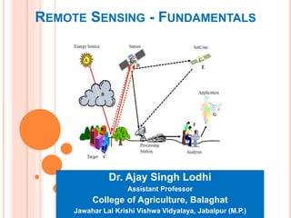
  • 1. REMOTE SENSING - FUNDAMENTALS Dr. Ajay Singh Lodhi Assistant Professor College of Agriculture, Balaghat Jawahar Lal Krishi Vishwa Vidyalaya, Jabalpur (M.P.)
  • 2. REMOTE SENSING SENSORS  Passive sensors: Passive system record energy reflected or emitted by a target illuminated by sun.  e.g. normal photography, most optical satellite sensors.  Active sensors: Active system illuminates target with energy and measure reflection.  e.g. Radar sensors,
  • 3. Passive Remote Sensing  Doesn’t employ any external source of energy.  Measures either reflected radiation from Sun (can be operated only during daytime) or the emitted radiation from the surface (day/night operation).  Suffers from variable illumination conditions of Sun and influence of atmospheric conditions Active Remote sensing  Has its own source of energy  Active sensors emit a controlled beam of energy to the surface and measure the amount of energy reflected back to the sensor.  Controlled illumination signal  Day/night operation
  • 4. Passive sensors : collect electromagnetic radiation in the visible and infra-red part of the spectrum.  Aerial Photographs  Low resolution: Landsat,, SPOT, IRS  High Resolution: Quickbird, IKONOS Active sensors : generate their own radiation.  Air-borne RADAR  Space borne RADAR: ERS 1 / 2, Radarsat  LiDAR (laser scanner)
  • 5. FUNDAMENTAL PHYSICS OF REMOTE SENSING  Remote Sensing relies on the measurement of Electro Magnetic (EM) energy.  The most important source of EM energy is the sun Some sensors detect energy emitted by the Earth itself or provide their own energy (Radar) .  All matter reflects, penetrate, observes and emits of EMR in unique way, which called spectral characteristics  Two characteristic of electromagnetic radiation are particularly important for understanding remote sensing. These are the wavelength and frequency.
  • 6.  The wave length is the length of one wave cycle which can be measured as the distance between successive Wave crests.  Wave length is usually represented by the lambda wave length is measured in meter (M) or some factors of meters such as nanometers (nm) micrometers(um) , centimeters (cm)  Frequency refers to the number of cycles of waves passing a fixed point per unit of time. Frequency is normally measured in hertz (Hz), equivalent to one cycle per second and various multiples of hertz.
  • 7.  Relation between Wavelength and Frequency: Wavelength and frequency are related by the following formula: 𝐶 = 𝜆𝑣 Where 𝜆 = Wavelength (m) 𝑣= frequency (cycles per second, Hz) c = speed of light (3x10⁸ m/s) Therefore, the two are inversely related to each other. The shorter the wave length, the higher the frequency. The longer the wave length, the lower frequency
  • 8.  Electro-magnetic spectrum (EMS) is an array of all EMR, which moves velocity of light, characteristic of wavelength and frequency of energy.  The electromagnetic spectrum ranges from the shorter wavelengths (including gamma and x-rays) to the longer wavelengths (including microwaves and broadcast radio waves)  There are several regions of the electromagnetic spectrum which are useful for remote sensing. Electromagnetic Spectrum (EMS)
  • 9.
  • 10. Ultraviolet Range  This radiation is just beyond the violet portion of the visible wavelengths  Some Earth surface materials, primarily rocks and minerals, emit visible light when illuminated by UV radiation. Visible Range  The light which our eyes - our "remote sensors" can detect is part of the visible spectrum.  The visible wavelengths cover a range from approximately 0.4 to 0.7 µm. The longest visible wavelength is red and the shortest is violet .This is the only portion of the spectrum we can associate with the concept of colours.
  • 11.
  • 12.
  • 13.
  • 14.
  • 15.
  • 16. REMOTE SENSING OBSERVATION PLATFORM  Sensor-the device that actually gathers the remotely sensed data  Platform-the device to which the sensor is attached  The vehicles or carriers for remote sensing are called the platform.  Based on its altitude above earth surface typically platform are satellite and aircraft but they can also, aero plane, balloons, kites. platform may be classified as, 1) Ground borne 2) Air borne 3) Space borne
  • 17.  Air born and space born platform have been in use in remote sensing of earth resources.  The ground based remote sensing system for earth resources studies are mainly used for collecting the ground truth or for laboratory simulation studies.
  • 18.
  • 19.
  • 20.
  • 21.