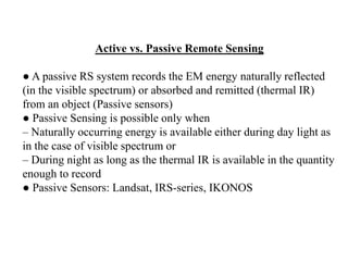
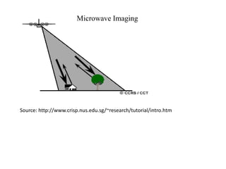
SlideShare a Scribd company logo
1 of 29
Remote Sensing – An Earth Perspective
Remote Sensing – Definition
● Acquisition of Earth information about the state and condition of
an object and/or a process through sensors that are not in physical
contact with it
– RS also includes analysis and interpretation of the acquired
information
– RS: an extension of eye
● Raise our 'eyes' above the surface for synoptic view
● Extend these 'eyes' in to different spectrum to 'see‘ through 'clouds'
and to 'see' at night
● Therefore it is an energy interaction between the target and the
sensor
– Energy: Sun (Passive)
– Energy: Artificial such as Radar, Lasers (Active)
Human Eyes vs. RS
● Human Eyes has 3 major limitations
– Limited to only Visible spectrum
– Dependent on external energy source (Sun)
– Limitation to our own height causing
restricted observation capabilities
Remote Sensing - History
● Hot Air Balloon – 1858 (First aerial photography
above 80m height in Bievre, France)
● Kites – 1880s by British
● Carrier Pigeon camera – Early 1900s
● Airplane photography – first time in 1909 in Italy
● From 1915-1960s: extensive use of aerial
photography for military and civilian use
● First aerial multispectral photograph – 1930 in
Russia
● 1931 – first non-visible (in NIR) film developed by
Kodak research laboratories
● 1947 - First space-borne photo, about 200 km above
space in New Mexico
● Sputnik by Soviet Union: 1957
● First Space program launched: April 1960 by NASA for global
cloud patterns, named Television and Infrared Observation Satellites
● First Satellite RS: Landsat 1- July 23, 1972
● First Indian RS Satellites: IRS–1 in March 1988
● First Commercial satellites IKONOS – 1999
● Quickbird – 2001 (in April 2011 it was raised from from an orbit
of 450km to 482km & on jan 2015 quick bird reenters in earth’s
atmosphere)
Remote Sensing – History (cont.)
RS – Some Basic
● Albedo (for a given surface) = Exitance (all outgoing) /
Irradiance (all incidence)
● Spectral signature: behaviour of an object over various
wavelength of EM, e.g. Snow appears
– 'White' in 'Visible' region (white is produced due to high
and equal amount of Blue, Green and Red
– 'Black' in 'SWIR' (reflectance is near-zero in longer
wavelength) region
● Pixel – radiance measurement at every n meters (unit
area covered by the sensor in a digital image) – a basic
unit of information
● DN: Digital number - a brightness value of the pixel (volts
converted in to intensity value from 0-255 in 8-bit format
Resolution
● Resolution – an ability to distinguish between two
closely space points
– Spectral (VIS, NIR..)
– Spatial (10cm, 1m, 30m, 200m, 1km..)
– Radiometric (8- or 16-bit) - an ability of an imaging
system to differentiate very slight variation in the
energy, i.e. it denotes the sensitivity of a sensor
– Temporal (1972, 2012) – revisiting period of a
sensor
– Angular resolution: sensor's capacity to make
observation of the same area from different angles
Pixel size and Resolution; Intensity
● Pixel size and Resolution:
– Sensor's Resolution Cell = IFOV * A
● Sensor's Resolution Cell is fixed at a particular time of recording
at a particular place
● But Pixel resolution may vary depending on the resampling unit
● Intensity: Total quantity of reflected energy received by a cell in a
given spectral band
– Therefore, intensity value changes in different EM spectrum
– 'Brightness' relates to intensity
Mapping Scale
● Mapping Scale: it shows how many times items represented in a
map are smaller than in reality
– Large scale (1:10,000): low reduction in reality, more detailed
information
– Small scale (1:50,000): large reduction in reality, less detailed
information
● Large mapping scale requires high spatial resolution images and
vice-verse
RELIEF
● A quantitative measurement of vertical elevation change in a
landscape
● It is the difference between maximum and minimum elevations
within a given area
– The relief of a landscape can change with the size of the area over
which it is measured, making the definition of the scale over which it
is measured very important
– Because it is related to the slope of surfaces within the area of
interest and to the gradient of any streams present, the relief of a
landscape is a useful metric in the study of the Earth's surface
SLOPE
● Slope: The slope is commonly taught as "rise over run"
or rise/run between two points on a line.
● In mathematics, the slope or gradient of a line describes
its steepness, incline, or grade. A higher slope value
indicates a steeper incline.
SLOPE Cont..
● The rise of a road between two points is the difference between the altitude
of the road at those two points, say y1 and y2, or in other words, the rise is
(y2 − y1) = Δy.
● For relatively short distances - where the earth's curvature may be
neglected, the run is the difference in distance from a fixed point measured
along a level, horizontal line, or in other words, the run is (x2 − x1) = Δx.
● Here the slope of the road between the two points is simply described as
the
ratio of the altitude change to the horizontal distance between any two points
on the line. In mathematical language,
the slope m of the line is m = Δy/Δx
● The concept of slope applies directly to grades or gradients in geography
and civil engineering.
● Through trigonometry, the grade m of a road is related to its angle of
incline
θ by m = tanθ; The larger the absolute value of a slope, the steeper the line.
● θ= arctan m
Contours
● In cartography, a contour line joins points of equal elevation
(height) above a given level, such as mean sea level
● A contour map is a map illustrated with contour lines, for
example a topographic map, which thus shows valleys and hills,
and the steepness of slopes
● The contour interval of a contour map is the difference in
elevation between successive contour lines
● When the lines are close together the magnitude of the gradient
is large: the variation is steep. A level set is a generalization of a
contour line for functions of any number of variables
● Contour lines are curved or straight lines on a map describing
the intersection of a real or hypothetical surface with one or
more horizontal planes
Optical Remote Sensing
● Imaging in visible, NIR and SWIR of the earth's surface by
detecting the solar radiation reflected from targets on the ground
● Different materials reflect and absorb differently at different
wavelengths
– Thus, the targets can be differentiated by their spectral reflectance
signatures in the remotely sensed images
Optical Remote Sensing
Source: http://www.crisp.nus.edu.sg/~research/tutorial/intro.htm
Optical RS – Types
● Depending on the number of spectral bands used in the
imaging process, Optical RS systems are classified into
● Panchromatic imaging system
● Multispectral ” ”
● Superspectral ” ”
● Hyperspectral ” ”
Active vs. Passive Remote Sensing
● A passive RS system records the EM energy naturally reflected
(in the visible spectrum) or absorbed and remitted (thermal IR)
from an object (Passive sensors)
● Passive Sensing is possible only when
– Naturally occurring energy is available either during day light as
in the case of visible spectrum or
– During night as long as the thermal IR is available in the quantity
enough to record
● Passive Sensors: Landsat, IRS-series, IKONOS
Active vs. Passive Remote Sensing
Source:http://www.oneonta.edu/faculty/baumanpr/geosat2/RS-Introduction/RS-
Introduction.html
Source: http://www.nrcan.gc.ca/earth-
sciences/geographyboundary/
remote-sensing/fundamentals/1212
Active vs. Passive RS Cont..
● An Active RS system supplies its own source of EM energy,
which is directed at the object in order to measure the returned
energy (Active sensors)
– Flash photography is active Remote Sensing in contrast to
available light photography, which is passive
● Active Sensors: RADARSAT, LiDAR, SRTM
● RADAR, which provides its own source of EM energy in the
microwave region
● LASER or LiDAR is a relatively new form of active Remote
Sensing, operating in the visible and NIR wavelength bands
● It encompasses both active and passive RS
● Microwave wavelength spectrum: 1cm to 1m
● Microwave wavelength long- special properties, not susceptible to
atmospheric scattering which affects shorter optical wavelengths
● It penetrate through cloud cover, haze, dust, and all but the heaviest
rainfall
● Detection of microwave energy under almost all weather and
environmental conditions so that data can be collected at any time
Microwave or RADAR Remote Sensing
Passive Microwave Sensing
● All objects emit microwave energy of some magnitude, but the
amounts are generally very small
● A passive microwave sensor (radiometers or scanners) detects
the naturally emitted microwave energy within its field of view
by its antenna
● This emitted energy is related to the temp. and moisture
properties of the emitting object or surface
Passive Microwave Sensing
Source: http://www.nrcan.gc.ca/earth-sciences/geography-boundary/remote-
sensing/fundamentals/2021
Application of Passive Microwave RS
● Meteorology, hydrology, and oceanography
● By looking "at", or "through" the atmosphere, depending on the
wavelength, Meteorologists can use passive microwaves to measure
atmospheric profiles and to determine water and ozone content in the
atmosphere
● Hydrologists use passive microwaves to measure soil moisture
since microwave emission is influenced by moisture content
● Oceanography - mapping sea ice, currents, and surface winds as
well as detection of pollutants, such as oil slicks
Active Microwave or RADAR RS
● RADAR - Radio Detection And Ranging
● Active radar sensors emit microwave radiation in a series of
pulses from an antenna, looking obliquely at the surface
perpendicular to the direction of motion
● When the energy reaches the target, some of the energy is
reflected back towards the sensor. This backscattered microwave
radiation is detected, measured, and timed
● The time required for the energy to travel to the target and return
back to the sensor determines the distance or range to the target
● By recording the range and magnitude of the energy reflected
from all targets as the system passes by, a two dimensional image of
the surface can be produced
● Also, microwave energy is able to penetrate through clouds and
most rain, making it an all-weather sensor
Microwave Imaging
Source: http://www.crisp.nus.edu.sg/~research/tutorial/intro.htm
● Active microwave sensors divided into two
distinct categories:
– imaging and non-imaging
● RADAR - RAdio Detection And Ranging: The
most common imaging active MW sensor
● Altimeters and scatterometers - Non-imaging
microwave sensors
● They are profiling devices which measure in
one linear dimension (as opposed to the twodimensional
representation of imaging sensors)
Active Microwave Sensors
Non-imaging Active MW sensors
● RADAR altimeters transmit short MW pulses (Nadir looking) and
measure the round trip time delay to targets for the target-sensor
distance
● RADAR altimetry is used for altitude finding, topographic
mapping and sea surface height estimation
● Scatterometers are used to measure the amount of energy
backscattered from targets
– The amount of energy backscattered is dependent
on the surface properties (roughness) and
– The angle at which the MW energy strikes the target
Application of Scatterometry MW
● Scatterometry measurements over ocean surfaces can be used to
estimate wind speeds based on the sea surface roughness
● Ground-based scatterometers are used to characterize different
materials and surface types (analogous to the concept of spectral
reflectance curves in the optical spectrum)
Reference Books
● Remote sensing: principles and interpretation
Floyd F. Sabins (Publisher: W.H. Freeman and Company,
1997)
● Introduction to remote sensing, James B. Campbell and
Randolph H. Wynne (5th ed., 2011)
● Remote Sensing And Image Interpretation, Thomas M.
Lillesand, Ralph W. Kiefer, Jonathan W. Chipman, 6th Ed.,
2008
● An Introduction to Geographical Information Systems,
Heywood Ian, Pearson Education India, 2010
● A Primer of GIS: Fundamental Geographic and
Cartographic Concepts, Francis Harvey, The Guilford.

More Related Content

What's hot

Sources of errors in GNSS measurements and dilution of precision (DOP) parame...
Sources of errors in GNSS measurements and dilution of precision (DOP) parame...Sources of errors in GNSS measurements and dilution of precision (DOP) parame...
Sources of errors in GNSS measurements and dilution of precision (DOP) parame...Olexiy Pogurelskiy
 
Relativistic Effect in GPS Satellite and Computation of Time Error
Relativistic Effect in GPS Satellite and Computation of Time Error Relativistic Effect in GPS Satellite and Computation of Time Error
Relativistic Effect in GPS Satellite and Computation of Time Error Vedant Srivastava
 
Satellite Based Positioning.
Satellite Based Positioning.Satellite Based Positioning.
Satellite Based Positioning.saddamshaikh41
 
Gps surveying in Engineering
Gps surveying in EngineeringGps surveying in Engineering
Gps surveying in EngineeringGaneshRaj44
 
Aircraft Navigation- INS / GPS
Aircraft Navigation- INS / GPSAircraft Navigation- INS / GPS
Aircraft Navigation- INS / GPSshankar11122
 
Introduction to Landsat
Introduction to LandsatIntroduction to Landsat
Introduction to LandsatNizam GIS
 
Remote Sensing Platforms and Its types
Remote Sensing Platforms and Its typesRemote Sensing Platforms and Its types
Remote Sensing Platforms and Its typesSenthamizhan M
 
Psa final presentation on gps ....for Rethwan Faiz sir
Psa final presentation on gps ....for Rethwan Faiz sirPsa final presentation on gps ....for Rethwan Faiz sir
Psa final presentation on gps ....for Rethwan Faiz sirSadman Sakib
 
Envi sat satellite
Envi sat satelliteEnvi sat satellite
Envi sat satelliteEhsanYousaf1
 
GNSS Satellite System Basics by ASIM khan GNSS-7
GNSS Satellite System Basics  by ASIM khan GNSS-7GNSS Satellite System Basics  by ASIM khan GNSS-7
GNSS Satellite System Basics by ASIM khan GNSS-7AsimKhan367
 
02 chapter: Earthquake: Strong Motion and Estimation of Seismic Hazard
02 chapter: Earthquake: Strong Motion and Estimation of Seismic Hazard02 chapter: Earthquake: Strong Motion and Estimation of Seismic Hazard
02 chapter: Earthquake: Strong Motion and Estimation of Seismic HazardPriodeep Chowdhury
 
Keplerian orbital elements (lecture 2)
Keplerian orbital elements (lecture 2)Keplerian orbital elements (lecture 2)
Keplerian orbital elements (lecture 2)Olexiy Pogurelskiy
 
Earth Science G10 Module 1 Activity 1
Earth Science G10 Module 1 Activity 1Earth Science G10 Module 1 Activity 1
Earth Science G10 Module 1 Activity 1Alfred Gico
 
Satellite detail Asim khan GNSS-7 IST
Satellite detail  Asim khan GNSS-7 ISTSatellite detail  Asim khan GNSS-7 IST
Satellite detail Asim khan GNSS-7 ISTAsimKhan367
 

What's hot (20)

Navigation
NavigationNavigation
Navigation
 
Gps
GpsGps
Gps
 
Global positioningsystem
Global positioningsystemGlobal positioningsystem
Global positioningsystem
 
Sources of errors in GNSS measurements and dilution of precision (DOP) parame...
Sources of errors in GNSS measurements and dilution of precision (DOP) parame...Sources of errors in GNSS measurements and dilution of precision (DOP) parame...
Sources of errors in GNSS measurements and dilution of precision (DOP) parame...
 
Relativistic Effect in GPS Satellite and Computation of Time Error
Relativistic Effect in GPS Satellite and Computation of Time Error Relativistic Effect in GPS Satellite and Computation of Time Error
Relativistic Effect in GPS Satellite and Computation of Time Error
 
Satellite Based Positioning.
Satellite Based Positioning.Satellite Based Positioning.
Satellite Based Positioning.
 
Gps surveying in Engineering
Gps surveying in EngineeringGps surveying in Engineering
Gps surveying in Engineering
 
Aircraft Navigation- INS / GPS
Aircraft Navigation- INS / GPSAircraft Navigation- INS / GPS
Aircraft Navigation- INS / GPS
 
Introduction to Landsat
Introduction to LandsatIntroduction to Landsat
Introduction to Landsat
 
Remote Sensing Platforms and Its types
Remote Sensing Platforms and Its typesRemote Sensing Platforms and Its types
Remote Sensing Platforms and Its types
 
Psa final presentation on gps ....for Rethwan Faiz sir
Psa final presentation on gps ....for Rethwan Faiz sirPsa final presentation on gps ....for Rethwan Faiz sir
Psa final presentation on gps ....for Rethwan Faiz sir
 
Envi sat satellite
Envi sat satelliteEnvi sat satellite
Envi sat satellite
 
The gps dictionary
The gps dictionaryThe gps dictionary
The gps dictionary
 
GNSS Satellite System Basics by ASIM khan GNSS-7
GNSS Satellite System Basics  by ASIM khan GNSS-7GNSS Satellite System Basics  by ASIM khan GNSS-7
GNSS Satellite System Basics by ASIM khan GNSS-7
 
GPS Orbits
GPS OrbitsGPS Orbits
GPS Orbits
 
02 chapter: Earthquake: Strong Motion and Estimation of Seismic Hazard
02 chapter: Earthquake: Strong Motion and Estimation of Seismic Hazard02 chapter: Earthquake: Strong Motion and Estimation of Seismic Hazard
02 chapter: Earthquake: Strong Motion and Estimation of Seismic Hazard
 
Keplerian orbital elements (lecture 2)
Keplerian orbital elements (lecture 2)Keplerian orbital elements (lecture 2)
Keplerian orbital elements (lecture 2)
 
Nock nov99
Nock nov99Nock nov99
Nock nov99
 
Earth Science G10 Module 1 Activity 1
Earth Science G10 Module 1 Activity 1Earth Science G10 Module 1 Activity 1
Earth Science G10 Module 1 Activity 1
 
Satellite detail Asim khan GNSS-7 IST
Satellite detail  Asim khan GNSS-7 ISTSatellite detail  Asim khan GNSS-7 IST
Satellite detail Asim khan GNSS-7 IST
 

Similar to Remote sensing

Surveying ii ajith sir class5
Surveying ii ajith sir class5Surveying ii ajith sir class5
Surveying ii ajith sir class5SHAMJITH KM
 
rsbasics-150227022648-conversion-gate01.pptx
rsbasics-150227022648-conversion-gate01.pptxrsbasics-150227022648-conversion-gate01.pptx
rsbasics-150227022648-conversion-gate01.pptxBSuresh26
 
RS - Presentation by AP2023.pptx
RS - Presentation by AP2023.pptxRS - Presentation by AP2023.pptx
RS - Presentation by AP2023.pptxDrAbhishekPandey9
 
Unit 1 introduction to remote sensing
Unit  1 introduction to remote sensing Unit  1 introduction to remote sensing
Unit 1 introduction to remote sensing Dhanalakshmi Dasari
 
Basics of Remote Sensing
Basics of Remote SensingBasics of Remote Sensing
Basics of Remote SensingAkash Tikhe
 
Chapter 3: Remote sensing Technology
Chapter 3: Remote sensing TechnologyChapter 3: Remote sensing Technology
Chapter 3: Remote sensing TechnologyShankar Gangaju
 
Remote sensing - Sensors, Platforms and Satellite orbits
Remote sensing - Sensors, Platforms and Satellite orbitsRemote sensing - Sensors, Platforms and Satellite orbits
Remote sensing - Sensors, Platforms and Satellite orbitsAjay Singh Lodhi
 
Microwave remote sensing
Microwave remote sensingMicrowave remote sensing
Microwave remote sensingRohit Kumar
 
Basic Concepts of Remote Sensing
Basic Concepts of Remote Sensing Basic Concepts of Remote Sensing
Basic Concepts of Remote Sensing Somenath Goswami
 
Remote sensing in entomology
Remote sensing in entomologyRemote sensing in entomology
Remote sensing in entomologySatishGolla6
 
APPLICATION OF REMOTE SENSING AND GIS IN AGRICULTURE
APPLICATION OF REMOTE SENSING AND GIS IN AGRICULTUREAPPLICATION OF REMOTE SENSING AND GIS IN AGRICULTURE
APPLICATION OF REMOTE SENSING AND GIS IN AGRICULTURELagnajeetRoy
 
Concepts of Remote Sensing: Process and Stages of Remote Sensing, Remote Sens...
Concepts of Remote Sensing: Process and Stages of Remote Sensing, Remote Sens...Concepts of Remote Sensing: Process and Stages of Remote Sensing, Remote Sens...
Concepts of Remote Sensing: Process and Stages of Remote Sensing, Remote Sens...ShavnamMehta
 

Similar to Remote sensing (20)

RS_GIS_GPS.pdf
RS_GIS_GPS.pdfRS_GIS_GPS.pdf
RS_GIS_GPS.pdf
 
Remote sensing
Remote sensingRemote sensing
Remote sensing
 
Surveying ii ajith sir class5
Surveying ii ajith sir class5Surveying ii ajith sir class5
Surveying ii ajith sir class5
 
remote sensing
remote sensingremote sensing
remote sensing
 
Remote sensing
Remote sensingRemote sensing
Remote sensing
 
rsbasics-150227022648-conversion-gate01.pptx
rsbasics-150227022648-conversion-gate01.pptxrsbasics-150227022648-conversion-gate01.pptx
rsbasics-150227022648-conversion-gate01.pptx
 
Remote sensing
Remote sensingRemote sensing
Remote sensing
 
Iirs rstechnologypdf
Iirs rstechnologypdfIirs rstechnologypdf
Iirs rstechnologypdf
 
RS - Presentation by AP2023.pptx
RS - Presentation by AP2023.pptxRS - Presentation by AP2023.pptx
RS - Presentation by AP2023.pptx
 
Unit 1 introduction to remote sensing
Unit  1 introduction to remote sensing Unit  1 introduction to remote sensing
Unit 1 introduction to remote sensing
 
Basics of Remote Sensing
Basics of Remote SensingBasics of Remote Sensing
Basics of Remote Sensing
 
Chapter 3: Remote sensing Technology
Chapter 3: Remote sensing TechnologyChapter 3: Remote sensing Technology
Chapter 3: Remote sensing Technology
 
Radar tech.ppt
Radar tech.pptRadar tech.ppt
Radar tech.ppt
 
Remote sensing - Sensors, Platforms and Satellite orbits
Remote sensing - Sensors, Platforms and Satellite orbitsRemote sensing - Sensors, Platforms and Satellite orbits
Remote sensing - Sensors, Platforms and Satellite orbits
 
Microwave remote sensing
Microwave remote sensingMicrowave remote sensing
Microwave remote sensing
 
Basic Concepts of Remote Sensing
Basic Concepts of Remote Sensing Basic Concepts of Remote Sensing
Basic Concepts of Remote Sensing
 
Remote sensing in entomology
Remote sensing in entomologyRemote sensing in entomology
Remote sensing in entomology
 
APPLICATION OF REMOTE SENSING AND GIS IN AGRICULTURE
APPLICATION OF REMOTE SENSING AND GIS IN AGRICULTUREAPPLICATION OF REMOTE SENSING AND GIS IN AGRICULTURE
APPLICATION OF REMOTE SENSING AND GIS IN AGRICULTURE
 
Concepts of Remote Sensing: Process and Stages of Remote Sensing, Remote Sens...
Concepts of Remote Sensing: Process and Stages of Remote Sensing, Remote Sens...Concepts of Remote Sensing: Process and Stages of Remote Sensing, Remote Sens...
Concepts of Remote Sensing: Process and Stages of Remote Sensing, Remote Sens...
 
concepts of RM.ppt
concepts of RM.pptconcepts of RM.ppt
concepts of RM.ppt
 

Recently uploaded

Botany 4th semester series (krishna).pdf
Botany 4th semester series (krishna).pdfBotany 4th semester series (krishna).pdf
Botany 4th semester series (krishna).pdfSumit Kumar yadav
 
Presentation Vikram Lander by Vedansh Gupta.pptx
Presentation Vikram Lander by Vedansh Gupta.pptxPresentation Vikram Lander by Vedansh Gupta.pptx
Presentation Vikram Lander by Vedansh Gupta.pptxgindu3009
 
SAMASTIPUR CALL GIRL 7857803690 LOW PRICE ESCORT SERVICE
SAMASTIPUR CALL GIRL 7857803690  LOW PRICE  ESCORT SERVICESAMASTIPUR CALL GIRL 7857803690  LOW PRICE  ESCORT SERVICE
SAMASTIPUR CALL GIRL 7857803690 LOW PRICE ESCORT SERVICEayushi9330
 
American Type Culture Collection (ATCC).pptx
American Type Culture Collection (ATCC).pptxAmerican Type Culture Collection (ATCC).pptx
American Type Culture Collection (ATCC).pptxabhishekdhamu51
 
module for grade 9 for distance learning
module for grade 9 for distance learningmodule for grade 9 for distance learning
module for grade 9 for distance learninglevieagacer
 
Vip profile Call Girls In Lonavala 9748763073 For Genuine Sex Service At Just...
Vip profile Call Girls In Lonavala 9748763073 For Genuine Sex Service At Just...Vip profile Call Girls In Lonavala 9748763073 For Genuine Sex Service At Just...
Vip profile Call Girls In Lonavala 9748763073 For Genuine Sex Service At Just...Monika Rani
 
Labelling Requirements and Label Claims for Dietary Supplements and Recommend...
Labelling Requirements and Label Claims for Dietary Supplements and Recommend...Labelling Requirements and Label Claims for Dietary Supplements and Recommend...
Labelling Requirements and Label Claims for Dietary Supplements and Recommend...Lokesh Kothari
 
Pulmonary drug delivery system M.pharm -2nd sem P'ceutics
Pulmonary drug delivery system M.pharm -2nd sem P'ceuticsPulmonary drug delivery system M.pharm -2nd sem P'ceutics
Pulmonary drug delivery system M.pharm -2nd sem P'ceuticssakshisoni2385
 
Proteomics: types, protein profiling steps etc.
Proteomics: types, protein profiling steps etc.Proteomics: types, protein profiling steps etc.
Proteomics: types, protein profiling steps etc.Silpa
 
Formation of low mass protostars and their circumstellar disks
Formation of low mass protostars and their circumstellar disksFormation of low mass protostars and their circumstellar disks
Formation of low mass protostars and their circumstellar disksSérgio Sacani
 
Discovery of an Accretion Streamer and a Slow Wide-angle Outflow around FUOri...
Discovery of an Accretion Streamer and a Slow Wide-angle Outflow around FUOri...Discovery of an Accretion Streamer and a Slow Wide-angle Outflow around FUOri...
Discovery of an Accretion Streamer and a Slow Wide-angle Outflow around FUOri...Sérgio Sacani
 
Botany 4th semester file By Sumit Kumar yadav.pdf
Botany 4th semester file By Sumit Kumar yadav.pdfBotany 4th semester file By Sumit Kumar yadav.pdf
Botany 4th semester file By Sumit Kumar yadav.pdfSumit Kumar yadav
 
Justdial Call Girls In Indirapuram, Ghaziabad, 8800357707 Escorts Service
Justdial Call Girls In Indirapuram, Ghaziabad, 8800357707 Escorts ServiceJustdial Call Girls In Indirapuram, Ghaziabad, 8800357707 Escorts Service
Justdial Call Girls In Indirapuram, Ghaziabad, 8800357707 Escorts Servicemonikaservice1
 
Connaught Place, Delhi Call girls :8448380779 Model Escorts | 100% verified
Connaught Place, Delhi Call girls :8448380779 Model Escorts | 100% verifiedConnaught Place, Delhi Call girls :8448380779 Model Escorts | 100% verified
Connaught Place, Delhi Call girls :8448380779 Model Escorts | 100% verifiedDelhi Call girls
 
Forensic Biology & Its biological significance.pdf
Forensic Biology & Its biological significance.pdfForensic Biology & Its biological significance.pdf
Forensic Biology & Its biological significance.pdfrohankumarsinghrore1
 
Pests of mustard_Identification_Management_Dr.UPR.pdf
Pests of mustard_Identification_Management_Dr.UPR.pdfPests of mustard_Identification_Management_Dr.UPR.pdf
Pests of mustard_Identification_Management_Dr.UPR.pdfPirithiRaju
 
Chemistry 4th semester series (krishna).pdf
Chemistry 4th semester series (krishna).pdfChemistry 4th semester series (krishna).pdf
Chemistry 4th semester series (krishna).pdfSumit Kumar yadav
 
Pests of cotton_Sucking_Pests_Dr.UPR.pdf
Pests of cotton_Sucking_Pests_Dr.UPR.pdfPests of cotton_Sucking_Pests_Dr.UPR.pdf
Pests of cotton_Sucking_Pests_Dr.UPR.pdfPirithiRaju
 

Recently uploaded (20)

Botany 4th semester series (krishna).pdf
Botany 4th semester series (krishna).pdfBotany 4th semester series (krishna).pdf
Botany 4th semester series (krishna).pdf
 
Presentation Vikram Lander by Vedansh Gupta.pptx
Presentation Vikram Lander by Vedansh Gupta.pptxPresentation Vikram Lander by Vedansh Gupta.pptx
Presentation Vikram Lander by Vedansh Gupta.pptx
 
SAMASTIPUR CALL GIRL 7857803690 LOW PRICE ESCORT SERVICE
SAMASTIPUR CALL GIRL 7857803690  LOW PRICE  ESCORT SERVICESAMASTIPUR CALL GIRL 7857803690  LOW PRICE  ESCORT SERVICE
SAMASTIPUR CALL GIRL 7857803690 LOW PRICE ESCORT SERVICE
 
American Type Culture Collection (ATCC).pptx
American Type Culture Collection (ATCC).pptxAmerican Type Culture Collection (ATCC).pptx
American Type Culture Collection (ATCC).pptx
 
module for grade 9 for distance learning
module for grade 9 for distance learningmodule for grade 9 for distance learning
module for grade 9 for distance learning
 
Vip profile Call Girls In Lonavala 9748763073 For Genuine Sex Service At Just...
Vip profile Call Girls In Lonavala 9748763073 For Genuine Sex Service At Just...Vip profile Call Girls In Lonavala 9748763073 For Genuine Sex Service At Just...
Vip profile Call Girls In Lonavala 9748763073 For Genuine Sex Service At Just...
 
Labelling Requirements and Label Claims for Dietary Supplements and Recommend...
Labelling Requirements and Label Claims for Dietary Supplements and Recommend...Labelling Requirements and Label Claims for Dietary Supplements and Recommend...
Labelling Requirements and Label Claims for Dietary Supplements and Recommend...
 
Pulmonary drug delivery system M.pharm -2nd sem P'ceutics
Pulmonary drug delivery system M.pharm -2nd sem P'ceuticsPulmonary drug delivery system M.pharm -2nd sem P'ceutics
Pulmonary drug delivery system M.pharm -2nd sem P'ceutics
 
Proteomics: types, protein profiling steps etc.
Proteomics: types, protein profiling steps etc.Proteomics: types, protein profiling steps etc.
Proteomics: types, protein profiling steps etc.
 
Site Acceptance Test .
Site Acceptance Test                    .Site Acceptance Test                    .
Site Acceptance Test .
 
Formation of low mass protostars and their circumstellar disks
Formation of low mass protostars and their circumstellar disksFormation of low mass protostars and their circumstellar disks
Formation of low mass protostars and their circumstellar disks
 
Discovery of an Accretion Streamer and a Slow Wide-angle Outflow around FUOri...
Discovery of an Accretion Streamer and a Slow Wide-angle Outflow around FUOri...Discovery of an Accretion Streamer and a Slow Wide-angle Outflow around FUOri...
Discovery of an Accretion Streamer and a Slow Wide-angle Outflow around FUOri...
 
Botany 4th semester file By Sumit Kumar yadav.pdf
Botany 4th semester file By Sumit Kumar yadav.pdfBotany 4th semester file By Sumit Kumar yadav.pdf
Botany 4th semester file By Sumit Kumar yadav.pdf
 
Justdial Call Girls In Indirapuram, Ghaziabad, 8800357707 Escorts Service
Justdial Call Girls In Indirapuram, Ghaziabad, 8800357707 Escorts ServiceJustdial Call Girls In Indirapuram, Ghaziabad, 8800357707 Escorts Service
Justdial Call Girls In Indirapuram, Ghaziabad, 8800357707 Escorts Service
 
Connaught Place, Delhi Call girls :8448380779 Model Escorts | 100% verified
Connaught Place, Delhi Call girls :8448380779 Model Escorts | 100% verifiedConnaught Place, Delhi Call girls :8448380779 Model Escorts | 100% verified
Connaught Place, Delhi Call girls :8448380779 Model Escorts | 100% verified
 
Forensic Biology & Its biological significance.pdf
Forensic Biology & Its biological significance.pdfForensic Biology & Its biological significance.pdf
Forensic Biology & Its biological significance.pdf
 
Pests of mustard_Identification_Management_Dr.UPR.pdf
Pests of mustard_Identification_Management_Dr.UPR.pdfPests of mustard_Identification_Management_Dr.UPR.pdf
Pests of mustard_Identification_Management_Dr.UPR.pdf
 
Chemistry 4th semester series (krishna).pdf
Chemistry 4th semester series (krishna).pdfChemistry 4th semester series (krishna).pdf
Chemistry 4th semester series (krishna).pdf
 
Clean In Place(CIP).pptx .
Clean In Place(CIP).pptx                 .Clean In Place(CIP).pptx                 .
Clean In Place(CIP).pptx .
 
Pests of cotton_Sucking_Pests_Dr.UPR.pdf
Pests of cotton_Sucking_Pests_Dr.UPR.pdfPests of cotton_Sucking_Pests_Dr.UPR.pdf
Pests of cotton_Sucking_Pests_Dr.UPR.pdf
 

Remote sensing

  • 1. Remote Sensing – An Earth Perspective
  • 2. Remote Sensing – Definition ● Acquisition of Earth information about the state and condition of an object and/or a process through sensors that are not in physical contact with it – RS also includes analysis and interpretation of the acquired information – RS: an extension of eye ● Raise our 'eyes' above the surface for synoptic view ● Extend these 'eyes' in to different spectrum to 'see‘ through 'clouds' and to 'see' at night ● Therefore it is an energy interaction between the target and the sensor – Energy: Sun (Passive) – Energy: Artificial such as Radar, Lasers (Active)
  • 3. Human Eyes vs. RS ● Human Eyes has 3 major limitations – Limited to only Visible spectrum – Dependent on external energy source (Sun) – Limitation to our own height causing restricted observation capabilities
  • 4. Remote Sensing - History ● Hot Air Balloon – 1858 (First aerial photography above 80m height in Bievre, France) ● Kites – 1880s by British ● Carrier Pigeon camera – Early 1900s ● Airplane photography – first time in 1909 in Italy ● From 1915-1960s: extensive use of aerial photography for military and civilian use ● First aerial multispectral photograph – 1930 in Russia ● 1931 – first non-visible (in NIR) film developed by Kodak research laboratories ● 1947 - First space-borne photo, about 200 km above space in New Mexico ● Sputnik by Soviet Union: 1957
  • 5. ● First Space program launched: April 1960 by NASA for global cloud patterns, named Television and Infrared Observation Satellites ● First Satellite RS: Landsat 1- July 23, 1972 ● First Indian RS Satellites: IRS–1 in March 1988 ● First Commercial satellites IKONOS – 1999 ● Quickbird – 2001 (in April 2011 it was raised from from an orbit of 450km to 482km & on jan 2015 quick bird reenters in earth’s atmosphere) Remote Sensing – History (cont.)
  • 6. RS – Some Basic ● Albedo (for a given surface) = Exitance (all outgoing) / Irradiance (all incidence) ● Spectral signature: behaviour of an object over various wavelength of EM, e.g. Snow appears – 'White' in 'Visible' region (white is produced due to high and equal amount of Blue, Green and Red – 'Black' in 'SWIR' (reflectance is near-zero in longer wavelength) region ● Pixel – radiance measurement at every n meters (unit area covered by the sensor in a digital image) – a basic unit of information ● DN: Digital number - a brightness value of the pixel (volts converted in to intensity value from 0-255 in 8-bit format
  • 7. Resolution ● Resolution – an ability to distinguish between two closely space points – Spectral (VIS, NIR..) – Spatial (10cm, 1m, 30m, 200m, 1km..) – Radiometric (8- or 16-bit) - an ability of an imaging system to differentiate very slight variation in the energy, i.e. it denotes the sensitivity of a sensor – Temporal (1972, 2012) – revisiting period of a sensor – Angular resolution: sensor's capacity to make observation of the same area from different angles
  • 8. Pixel size and Resolution; Intensity ● Pixel size and Resolution: – Sensor's Resolution Cell = IFOV * A ● Sensor's Resolution Cell is fixed at a particular time of recording at a particular place ● But Pixel resolution may vary depending on the resampling unit ● Intensity: Total quantity of reflected energy received by a cell in a given spectral band – Therefore, intensity value changes in different EM spectrum – 'Brightness' relates to intensity
  • 9. Mapping Scale ● Mapping Scale: it shows how many times items represented in a map are smaller than in reality – Large scale (1:10,000): low reduction in reality, more detailed information – Small scale (1:50,000): large reduction in reality, less detailed information ● Large mapping scale requires high spatial resolution images and vice-verse
  • 10. RELIEF ● A quantitative measurement of vertical elevation change in a landscape ● It is the difference between maximum and minimum elevations within a given area – The relief of a landscape can change with the size of the area over which it is measured, making the definition of the scale over which it is measured very important – Because it is related to the slope of surfaces within the area of interest and to the gradient of any streams present, the relief of a landscape is a useful metric in the study of the Earth's surface
  • 11. SLOPE ● Slope: The slope is commonly taught as "rise over run" or rise/run between two points on a line. ● In mathematics, the slope or gradient of a line describes its steepness, incline, or grade. A higher slope value indicates a steeper incline.
  • 12. SLOPE Cont.. ● The rise of a road between two points is the difference between the altitude of the road at those two points, say y1 and y2, or in other words, the rise is (y2 − y1) = Δy. ● For relatively short distances - where the earth's curvature may be neglected, the run is the difference in distance from a fixed point measured along a level, horizontal line, or in other words, the run is (x2 − x1) = Δx. ● Here the slope of the road between the two points is simply described as the ratio of the altitude change to the horizontal distance between any two points on the line. In mathematical language, the slope m of the line is m = Δy/Δx ● The concept of slope applies directly to grades or gradients in geography and civil engineering. ● Through trigonometry, the grade m of a road is related to its angle of incline θ by m = tanθ; The larger the absolute value of a slope, the steeper the line. ● θ= arctan m
  • 13. Contours ● In cartography, a contour line joins points of equal elevation (height) above a given level, such as mean sea level ● A contour map is a map illustrated with contour lines, for example a topographic map, which thus shows valleys and hills, and the steepness of slopes ● The contour interval of a contour map is the difference in elevation between successive contour lines ● When the lines are close together the magnitude of the gradient is large: the variation is steep. A level set is a generalization of a contour line for functions of any number of variables ● Contour lines are curved or straight lines on a map describing the intersection of a real or hypothetical surface with one or more horizontal planes
  • 14. Optical Remote Sensing ● Imaging in visible, NIR and SWIR of the earth's surface by detecting the solar radiation reflected from targets on the ground ● Different materials reflect and absorb differently at different wavelengths – Thus, the targets can be differentiated by their spectral reflectance signatures in the remotely sensed images
  • 15. Optical Remote Sensing Source: http://www.crisp.nus.edu.sg/~research/tutorial/intro.htm
  • 16. Optical RS – Types ● Depending on the number of spectral bands used in the imaging process, Optical RS systems are classified into ● Panchromatic imaging system ● Multispectral ” ” ● Superspectral ” ” ● Hyperspectral ” ”
  • 17. Active vs. Passive Remote Sensing ● A passive RS system records the EM energy naturally reflected (in the visible spectrum) or absorbed and remitted (thermal IR) from an object (Passive sensors) ● Passive Sensing is possible only when – Naturally occurring energy is available either during day light as in the case of visible spectrum or – During night as long as the thermal IR is available in the quantity enough to record ● Passive Sensors: Landsat, IRS-series, IKONOS
  • 18. Active vs. Passive Remote Sensing Source:http://www.oneonta.edu/faculty/baumanpr/geosat2/RS-Introduction/RS- Introduction.html Source: http://www.nrcan.gc.ca/earth- sciences/geographyboundary/ remote-sensing/fundamentals/1212
  • 19. Active vs. Passive RS Cont.. ● An Active RS system supplies its own source of EM energy, which is directed at the object in order to measure the returned energy (Active sensors) – Flash photography is active Remote Sensing in contrast to available light photography, which is passive ● Active Sensors: RADARSAT, LiDAR, SRTM ● RADAR, which provides its own source of EM energy in the microwave region ● LASER or LiDAR is a relatively new form of active Remote Sensing, operating in the visible and NIR wavelength bands
  • 20. ● It encompasses both active and passive RS ● Microwave wavelength spectrum: 1cm to 1m ● Microwave wavelength long- special properties, not susceptible to atmospheric scattering which affects shorter optical wavelengths ● It penetrate through cloud cover, haze, dust, and all but the heaviest rainfall ● Detection of microwave energy under almost all weather and environmental conditions so that data can be collected at any time Microwave or RADAR Remote Sensing
  • 21. Passive Microwave Sensing ● All objects emit microwave energy of some magnitude, but the amounts are generally very small ● A passive microwave sensor (radiometers or scanners) detects the naturally emitted microwave energy within its field of view by its antenna ● This emitted energy is related to the temp. and moisture properties of the emitting object or surface
  • 22. Passive Microwave Sensing Source: http://www.nrcan.gc.ca/earth-sciences/geography-boundary/remote- sensing/fundamentals/2021
  • 23. Application of Passive Microwave RS ● Meteorology, hydrology, and oceanography ● By looking "at", or "through" the atmosphere, depending on the wavelength, Meteorologists can use passive microwaves to measure atmospheric profiles and to determine water and ozone content in the atmosphere ● Hydrologists use passive microwaves to measure soil moisture since microwave emission is influenced by moisture content ● Oceanography - mapping sea ice, currents, and surface winds as well as detection of pollutants, such as oil slicks
  • 24. Active Microwave or RADAR RS ● RADAR - Radio Detection And Ranging ● Active radar sensors emit microwave radiation in a series of pulses from an antenna, looking obliquely at the surface perpendicular to the direction of motion ● When the energy reaches the target, some of the energy is reflected back towards the sensor. This backscattered microwave radiation is detected, measured, and timed ● The time required for the energy to travel to the target and return back to the sensor determines the distance or range to the target ● By recording the range and magnitude of the energy reflected from all targets as the system passes by, a two dimensional image of the surface can be produced ● Also, microwave energy is able to penetrate through clouds and most rain, making it an all-weather sensor
  • 26. ● Active microwave sensors divided into two distinct categories: – imaging and non-imaging ● RADAR - RAdio Detection And Ranging: The most common imaging active MW sensor ● Altimeters and scatterometers - Non-imaging microwave sensors ● They are profiling devices which measure in one linear dimension (as opposed to the twodimensional representation of imaging sensors) Active Microwave Sensors
  • 27. Non-imaging Active MW sensors ● RADAR altimeters transmit short MW pulses (Nadir looking) and measure the round trip time delay to targets for the target-sensor distance ● RADAR altimetry is used for altitude finding, topographic mapping and sea surface height estimation ● Scatterometers are used to measure the amount of energy backscattered from targets – The amount of energy backscattered is dependent on the surface properties (roughness) and – The angle at which the MW energy strikes the target
  • 28. Application of Scatterometry MW ● Scatterometry measurements over ocean surfaces can be used to estimate wind speeds based on the sea surface roughness ● Ground-based scatterometers are used to characterize different materials and surface types (analogous to the concept of spectral reflectance curves in the optical spectrum)
  • 29. Reference Books ● Remote sensing: principles and interpretation Floyd F. Sabins (Publisher: W.H. Freeman and Company, 1997) ● Introduction to remote sensing, James B. Campbell and Randolph H. Wynne (5th ed., 2011) ● Remote Sensing And Image Interpretation, Thomas M. Lillesand, Ralph W. Kiefer, Jonathan W. Chipman, 6th Ed., 2008 ● An Introduction to Geographical Information Systems, Heywood Ian, Pearson Education India, 2010 ● A Primer of GIS: Fundamental Geographic and Cartographic Concepts, Francis Harvey, The Guilford.