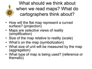
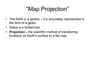
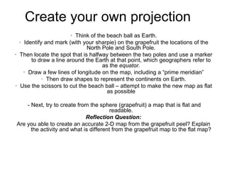
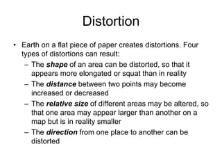
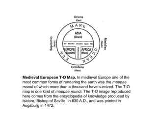
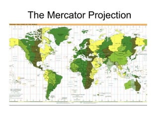
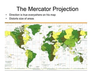
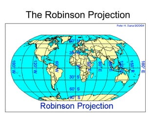
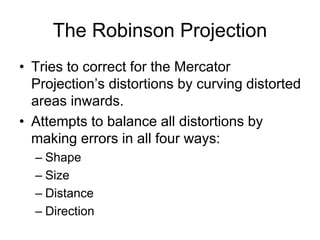
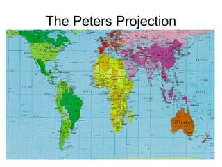
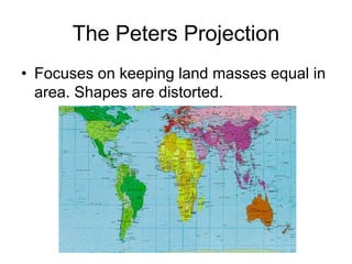
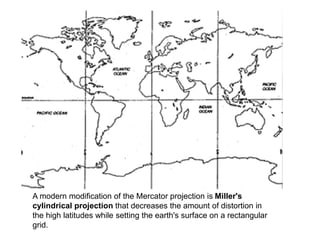
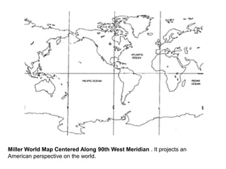
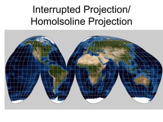
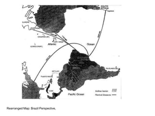
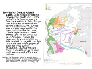
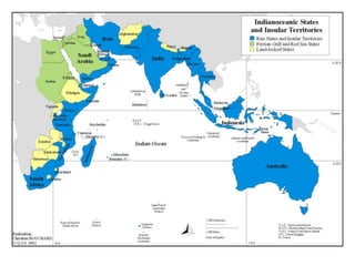
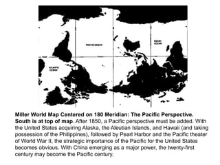
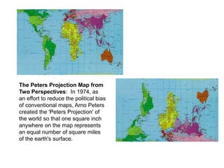
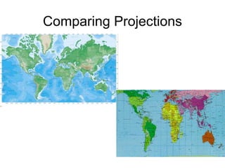
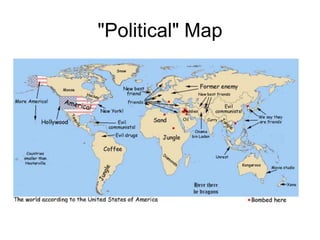
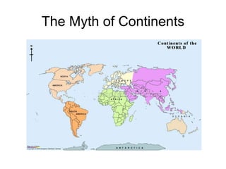
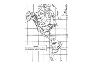
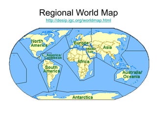
SlideShare a Scribd company logo
Map Projections &
Their Effects on
Perceptions in
the Study of
World History
What is a map?
• A generalized view of an area, usually
some portion of Earth’s surface, as seen
from above at a greatly reduced size
• Any geographical image of the
environment
• A two-dimensional representation of the
spatial distribution of selected phenomena
Why make a map?
• To represent a larger area than we can
see
• To show a phenomenon or process we
can’t see with our eyes
• To present information concisely
• To show spatial relationships
Represent a larger area
Show
what
we
can’t
see
Present info concisely
Show spatial
relationships
What should we think about
when we read maps? What do
cartographers think about?
• How will the flat map represent a curved
surface? (projection)
• Maps are selective views of reality
(simplification)
• Size of the map relative to reality (scale)
• What’s on the map (symbolization)
• What size of unit will be measured by the map
(aggregation)
• What type of map is being used? (reference or
thematic)
“Map Projection”
• The Earth is a sphere – it is accurately represented in
the form of a globe.
• Globe is a limited tool
• Projection – the scientific method of transferring
locations on Earth’s surface to a flat map
Create your own projection
· Think of the beach ball as Earth.
· Identify and mark (with your sharpie) on the grapefruit the locations of the
North Pole and South Pole.
· Then locate the spot that is halfway between the two poles and use a marker
to draw a line around the Earth at that point, which geographers refer to
as the equator.
· Draw a few lines of longitude on the map, including a “prime meridian”
· Then draw shapes to represent the continents on Earth.
· Use the scissors to cut the beach ball – attempt to make the new map as flat
as possible
- Next, try to create from the sphere (grapefruit) a map that is flat and
readable.
Reflection Question:
Are you able to create an accurate 2-D map from the grapefruit peel? Explain
the activity and what is different from the grapefruit map to the flat map?
Distortion
• Earth on a flat piece of paper creates distortions. Four
types of distortions can result:
– The shape of an area can be distorted, so that it
appears more elongated or squat than in reality
– The distance between two points may become
increased or decreased
– The relative size of different areas may be altered, so
that one area may appear larger than another on a
map but is in reality smaller
– The direction from one place to another can be
distorted
Medieval European T-O Map. In medieval Europe one of the
most common forms of rendering the earth was the mappae
mundi of which more than a thousand have survived. The T-O
map is one kind of mappae mundi. The T-O image reproduced
here comes from the encyclopedia of knowledge produced by
Isidore, Bishop of Seville, in 630 A.D., and was printed in
Augsburg in 1472.
The Maya Cosmos. Adopted with modifications from Linda Schele and
David Freidel, A Forest of Kings: The Untold Story of the Ancient Maya
(N.Y.: William Morrow, 1990), p. 67, fig. 2:1. Drawing by Linda Schele,
courtesy Foundation for the Advancement of Mesoamerican Studies, Inc.
(permissions Nov. 7, 2002).
An ancient map that strongly suggests Chinese sailors were first to round the world.
The Mercator Projection
• Direction is true everywhere on his map
• Distorts size of areas
The Robinson Projection
• Tries to correct for the Mercator
Projection’s distortions by curving distorted
areas inwards.
• Attempts to balance all distortions by
making errors in all four ways:
– Shape
– Size
– Distance
– Direction
The Peters Projection
• Focuses on keeping land masses equal in
area. Shapes are distorted.
The West Wing: Map
Projections
What does this clip reveal about
the importance of map
projections?
Other Projections
A modern modification of the Mercator projection is Miller's
cylindrical projection that decreases the amount of distortion in
the high latitudes while setting the earth's surface on a rectangular
grid.
Miller World Map Centered Along 90th West Meridian . It projects an
American perspective on the world.
Interrupted Projection/
Homolsoline Projection
Rearranged Map: Brazil Perspective,
Seventeenth Century Atlantic
Basin. Lines indicate direction of
movement of goods from Europe
and Africa to the Americas and
from the Americas to Asia. Europe
was the source of financial and
commercial activity, while Africa
was primarily important for the
slave trade—so that the main
cultural impacts were those of
Europe upon Africa, and Africa
upon America. This was the
transoceanic arena in which an
Atlantic World emerged in the Age
of Empire, and the geographical
stage for cross-cultural
encounters, Spanish treasure
fleets, a transatlantic slave trade,
and the movement of European
peoples.
Adopted with permission from D.W. Meining, The
Shaping of America: A Geographical Perspective on
500 Years of History. Volume 1, Atlantic America,
1492–1800 (Yale University Press, 1986), p. 56
North America appears to be more involved in the Pacific Basin than South
America (its eastward location pulling it toward the Atlantic). Finally, this
map reveals a major truth about the earth, and that is that the earth is
mostly water not land, the Pacific Ocean amounting to 64,000,000 square
miles (over twice the size of the Atlantic Ocean).
Miller World Map Centered on 180 Meridian: The Pacific Perspective.
South is at top of map. After 1850, a Pacific perspective must be added. With
the United States acquiring Alaska, the Aleutian Islands, and Hawaii (and taking
possession of the Philippines), followed by Pearl Harbor and the Pacific theater
of World War II, the strategic importance of the Pacific for the United States
becomes obvious. With China emerging as a major power, the twenty-first
century may become the Pacific century.
The Peters Projection Map from
Two Perspectives: In 1974, as
an effort to reduce the political bias
of conventional maps, Arno Peters
created the 'Peters Projection' of
the world so that one square inch
anywhere on the map represents
an equal number of square miles
of the earth's surface.
Comparing Projections
"Political" Map
The Myth of Continents
• The traditional notion of continents can be abandoned
(or at least modified). The idea of a North American
continent, separate from South America, encourages
false dichotomies that do not reflect actual biological,
geological, and cultural realities, and that overlooks
many themes that parallel the history of both regions
(from cowboy culture to urbanization).
• By substituting a world regionalism scheme for the
continental one, today's students will be using a regional
classification that better fits the realities of ethnicity,
culture, and history. This, then, would be the beginning
of an attempt to look at the New Old World in a new way.
Regional World Map
http://desip.igc.org/worldmap.html
Which map projection does the College Board use in their WHAP materials?

More Related Content

What's hot

Lec_6_Intro to geo-referencing
Lec_6_Intro to geo-referencingLec_6_Intro to geo-referencing
Lec_6_Intro to geo-referencingAtiqa khan
 
Map projections
Map projectionsMap projections
Map projections
Shayan Ahmad Yar
 
Geospatial reference-systems
Geospatial reference-systemsGeospatial reference-systems
Geospatial reference-systems
Stephen
 
Understanding Coordinate Systems and Projections for ArcGIS
Understanding Coordinate Systems and Projections for ArcGISUnderstanding Coordinate Systems and Projections for ArcGIS
Understanding Coordinate Systems and Projections for ArcGIS
John Schaeffer
 
Raster data and Vector data
Raster data and Vector dataRaster data and Vector data
Raster data and Vector data
Reham Maher El-Safarini
 
Projections and coordinate system
Projections and coordinate systemProjections and coordinate system
Projections and coordinate system
Mohsin Siddique
 
GIS - Topology
GIS - Topology GIS - Topology
GIS - Topology
Malla Reddy University
 
Types of aerial photographs
Types of aerial photographsTypes of aerial photographs
Types of aerial photographs
HARITHANAIR15
 
Basic coordinate system
Basic coordinate systemBasic coordinate system
Basic coordinate system
Shayan Ahmad Yar
 
Gis georeference
Gis georeferenceGis georeference
Gis georeference
Shah Naseer
 
Digital Cartography
Digital CartographyDigital Cartography
Digital Cartography
Patrick Woessner
 
Map scale and projection
Map scale and projectionMap scale and projection
Map scale and projectionlschmidt1170
 
groundtruth collection for remotesensing support
groundtruth collection for remotesensing supportgroundtruth collection for remotesensing support
groundtruth collection for remotesensing support
Thiruvengadam .
 
Remote Sensing error sources
Remote Sensing error sourcesRemote Sensing error sources
Remote Sensing error sourcesGilbert Okoth
 
Map projection
Map projectionMap projection
Map projection
kaslinsas
 
Introduction to Maps
Introduction to MapsIntroduction to Maps
Introduction to Maps
Malla Reddy University
 
History of cartography
History of cartographyHistory of cartography
Seminar on gis analysis functions
Seminar on gis analysis functionsSeminar on gis analysis functions
Seminar on gis analysis functions
Pramoda Raj
 
Relief displacement
Relief displacementRelief displacement
Relief displacement
Mr Amol Ghogare
 

What's hot (20)

Lec_6_Intro to geo-referencing
Lec_6_Intro to geo-referencingLec_6_Intro to geo-referencing
Lec_6_Intro to geo-referencing
 
Map projections
Map projectionsMap projections
Map projections
 
Geospatial reference-systems
Geospatial reference-systemsGeospatial reference-systems
Geospatial reference-systems
 
GIS - lecture-1.ppt
GIS - lecture-1.pptGIS - lecture-1.ppt
GIS - lecture-1.ppt
 
Understanding Coordinate Systems and Projections for ArcGIS
Understanding Coordinate Systems and Projections for ArcGISUnderstanding Coordinate Systems and Projections for ArcGIS
Understanding Coordinate Systems and Projections for ArcGIS
 
Raster data and Vector data
Raster data and Vector dataRaster data and Vector data
Raster data and Vector data
 
Projections and coordinate system
Projections and coordinate systemProjections and coordinate system
Projections and coordinate system
 
GIS - Topology
GIS - Topology GIS - Topology
GIS - Topology
 
Types of aerial photographs
Types of aerial photographsTypes of aerial photographs
Types of aerial photographs
 
Basic coordinate system
Basic coordinate systemBasic coordinate system
Basic coordinate system
 
Gis georeference
Gis georeferenceGis georeference
Gis georeference
 
Digital Cartography
Digital CartographyDigital Cartography
Digital Cartography
 
Map scale and projection
Map scale and projectionMap scale and projection
Map scale and projection
 
groundtruth collection for remotesensing support
groundtruth collection for remotesensing supportgroundtruth collection for remotesensing support
groundtruth collection for remotesensing support
 
Remote Sensing error sources
Remote Sensing error sourcesRemote Sensing error sources
Remote Sensing error sources
 
Map projection
Map projectionMap projection
Map projection
 
Introduction to Maps
Introduction to MapsIntroduction to Maps
Introduction to Maps
 
History of cartography
History of cartographyHistory of cartography
History of cartography
 
Seminar on gis analysis functions
Seminar on gis analysis functionsSeminar on gis analysis functions
Seminar on gis analysis functions
 
Relief displacement
Relief displacementRelief displacement
Relief displacement
 

Similar to map projections.ppt

World geography intro powerpoint
World geography  intro powerpointWorld geography  intro powerpoint
World geography intro powerpoint
confused1913
 
Unit1 160131210057
Unit1 160131210057Unit1 160131210057
Unit1 160131210057
sergio.historia
 
Notes on different terms of Geography
Notes on different terms of GeographyNotes on different terms of Geography
Notes on different terms of Geographyaprilrousseau
 
Geographical Themes and Terms
Geographical Themes and TermsGeographical Themes and Terms
Geographical Themes and Termsafrancksjrcs
 
5 themes and map skills
5 themes and map skills 5 themes and map skills
5 themes and map skills Úcar Marian
 
Introduction to geography
Introduction to geographyIntroduction to geography
Introduction to geography
Fco Javier Montaño Fdez
 
One world view
One world viewOne world view
Cartography – plotting the world
Cartography – plotting the worldCartography – plotting the world
Cartography – plotting the world
Nishant Sinha
 
Geography_Map Skills .pptx
 Geography_Map Skills .pptx Geography_Map Skills .pptx
Geography_Map Skills .pptx
NataliaBurgess
 
Intro to world geography skills
Intro to world geography skillsIntro to world geography skills
Intro to world geography skills
karrinem
 
Maps Projections and Treasure Hunt
Maps Projections and Treasure HuntMaps Projections and Treasure Hunt
Maps Projections and Treasure Hunt
Isabel Ramírez de Arellano Sevilla
 
Unit 1, part 3 the study of geography, cartographers' tools
Unit 1, part 3 the study of geography, cartographers' toolsUnit 1, part 3 the study of geography, cartographers' tools
Unit 1, part 3 the study of geography, cartographers' tools
montathomas
 
BASIC GEOGRAPHY 2011.ppt
BASIC GEOGRAPHY 2011.pptBASIC GEOGRAPHY 2011.ppt
BASIC GEOGRAPHY 2011.ppt
SatyavratDhull2
 
BASIC GEOGRAPHY 2011.ppt
BASIC GEOGRAPHY 2011.pptBASIC GEOGRAPHY 2011.ppt
BASIC GEOGRAPHY 2011.ppt
kirthick06K
 
Fostering Historical Inquiry in the Middle Years Classroom
Fostering Historical Inquiry in the Middle Years ClassroomFostering Historical Inquiry in the Middle Years Classroom
Fostering Historical Inquiry in the Middle Years Classroomcrhart
 

Similar to map projections.ppt (20)

World geography intro powerpoint
World geography  intro powerpointWorld geography  intro powerpoint
World geography intro powerpoint
 
Unit1 160131210057
Unit1 160131210057Unit1 160131210057
Unit1 160131210057
 
Notes on different terms of Geography
Notes on different terms of GeographyNotes on different terms of Geography
Notes on different terms of Geography
 
Geographical Themes and Terms
Geographical Themes and TermsGeographical Themes and Terms
Geographical Themes and Terms
 
5 themes and map skills
5 themes and map skills 5 themes and map skills
5 themes and map skills
 
Unit 1 geography
Unit 1 geographyUnit 1 geography
Unit 1 geography
 
Unit 1 geography
Unit 1 geographyUnit 1 geography
Unit 1 geography
 
Introduction to geography
Introduction to geographyIntroduction to geography
Introduction to geography
 
One world view
One world viewOne world view
One world view
 
Cartography – plotting the world
Cartography – plotting the worldCartography – plotting the world
Cartography – plotting the world
 
Geography_Map Skills .pptx
 Geography_Map Skills .pptx Geography_Map Skills .pptx
Geography_Map Skills .pptx
 
Intro to world geography skills
Intro to world geography skillsIntro to world geography skills
Intro to world geography skills
 
Maps Projections and Treasure Hunt
Maps Projections and Treasure HuntMaps Projections and Treasure Hunt
Maps Projections and Treasure Hunt
 
Unit 1, part 3 the study of geography, cartographers' tools
Unit 1, part 3 the study of geography, cartographers' toolsUnit 1, part 3 the study of geography, cartographers' tools
Unit 1, part 3 the study of geography, cartographers' tools
 
BASIC GEOGRAPHY 2011.ppt
BASIC GEOGRAPHY 2011.pptBASIC GEOGRAPHY 2011.ppt
BASIC GEOGRAPHY 2011.ppt
 
BASIC GEOGRAPHY 2011.ppt
BASIC GEOGRAPHY 2011.pptBASIC GEOGRAPHY 2011.ppt
BASIC GEOGRAPHY 2011.ppt
 
Fostering Historical Inquiry in the Middle Years Classroom
Fostering Historical Inquiry in the Middle Years ClassroomFostering Historical Inquiry in the Middle Years Classroom
Fostering Historical Inquiry in the Middle Years Classroom
 
Exploring geographic world
Exploring geographic worldExploring geographic world
Exploring geographic world
 
World map report
World map reportWorld map report
World map report
 
World map report
World map reportWorld map report
World map report
 

More from AntonetteAlbina3

Week 3 Robert Havighurst.pptx
Week 3 Robert Havighurst.pptxWeek 3 Robert Havighurst.pptx
Week 3 Robert Havighurst.pptx
AntonetteAlbina3
 
ESP 9 Q3 Week 3.pptx
ESP 9 Q3 Week 3.pptxESP 9 Q3 Week 3.pptx
ESP 9 Q3 Week 3.pptx
AntonetteAlbina3
 
RECOGNIZING STRESS.pdf
RECOGNIZING STRESS.pdfRECOGNIZING STRESS.pdf
RECOGNIZING STRESS.pdf
AntonetteAlbina3
 
Advance Physics Report.pptx
Advance Physics Report.pptxAdvance Physics Report.pptx
Advance Physics Report.pptx
AntonetteAlbina3
 
Week 4 How to Deal with Adulting.pptx
Week 4 How to Deal with Adulting.pptxWeek 4 How to Deal with Adulting.pptx
Week 4 How to Deal with Adulting.pptx
AntonetteAlbina3
 
Week 5 Mga Kasanayan Sa Akademikong Pagbasa.pptx
Week 5 Mga Kasanayan Sa Akademikong Pagbasa.pptxWeek 5 Mga Kasanayan Sa Akademikong Pagbasa.pptx
Week 5 Mga Kasanayan Sa Akademikong Pagbasa.pptx
AntonetteAlbina3
 
pshe-monday-think-positive.ppt
pshe-monday-think-positive.pptpshe-monday-think-positive.ppt
pshe-monday-think-positive.ppt
AntonetteAlbina3
 
Week 2 Developing the Whole Person.ppt
Week 2 Developing the Whole Person.pptWeek 2 Developing the Whole Person.ppt
Week 2 Developing the Whole Person.ppt
AntonetteAlbina3
 
Week 1-2 Uri ng Teksto Part 1.pptx
Week 1-2 Uri ng Teksto Part 1.pptxWeek 1-2 Uri ng Teksto Part 1.pptx
Week 1-2 Uri ng Teksto Part 1.pptx
AntonetteAlbina3
 
Week 3 Mga Panandang Kohesyong Gramatikal.pptx
Week 3 Mga Panandang Kohesyong Gramatikal.pptxWeek 3 Mga Panandang Kohesyong Gramatikal.pptx
Week 3 Mga Panandang Kohesyong Gramatikal.pptx
AntonetteAlbina3
 
PE 11 Week 1-2.pptx
PE 11 Week 1-2.pptxPE 11 Week 1-2.pptx
PE 11 Week 1-2.pptx
AntonetteAlbina3
 
Week 1-2 Uri ng Teksto Part 2.pptx
Week 1-2 Uri ng Teksto Part 2.pptxWeek 1-2 Uri ng Teksto Part 2.pptx
Week 1-2 Uri ng Teksto Part 2.pptx
AntonetteAlbina3
 
Recent Discoveries Relevant to Earth Science.pptx
Recent Discoveries Relevant to Earth Science.pptxRecent Discoveries Relevant to Earth Science.pptx
Recent Discoveries Relevant to Earth Science.pptx
AntonetteAlbina3
 
Molecular Genetics final.pptx
Molecular Genetics final.pptxMolecular Genetics final.pptx
Molecular Genetics final.pptx
AntonetteAlbina3
 
m9.pptx
m9.pptxm9.pptx
UCSP Week 1.pptx
UCSP Week 1.pptxUCSP Week 1.pptx
UCSP Week 1.pptx
AntonetteAlbina3
 
ESP 9 Q3 Week 1-2.pptx
ESP 9 Q3 Week 1-2.pptxESP 9 Q3 Week 1-2.pptx
ESP 9 Q3 Week 1-2.pptx
AntonetteAlbina3
 
12nayugtongmakataongkilos-221127112944-b3197067.pdf
12nayugtongmakataongkilos-221127112944-b3197067.pdf12nayugtongmakataongkilos-221127112944-b3197067.pdf
12nayugtongmakataongkilos-221127112944-b3197067.pdf
AntonetteAlbina3
 
weatheringfinal11-151223061952.pdf
weatheringfinal11-151223061952.pdfweatheringfinal11-151223061952.pdf
weatheringfinal11-151223061952.pdf
AntonetteAlbina3
 
Earth Science Report.pptx
Earth Science Report.pptxEarth Science Report.pptx
Earth Science Report.pptx
AntonetteAlbina3
 

More from AntonetteAlbina3 (20)

Week 3 Robert Havighurst.pptx
Week 3 Robert Havighurst.pptxWeek 3 Robert Havighurst.pptx
Week 3 Robert Havighurst.pptx
 
ESP 9 Q3 Week 3.pptx
ESP 9 Q3 Week 3.pptxESP 9 Q3 Week 3.pptx
ESP 9 Q3 Week 3.pptx
 
RECOGNIZING STRESS.pdf
RECOGNIZING STRESS.pdfRECOGNIZING STRESS.pdf
RECOGNIZING STRESS.pdf
 
Advance Physics Report.pptx
Advance Physics Report.pptxAdvance Physics Report.pptx
Advance Physics Report.pptx
 
Week 4 How to Deal with Adulting.pptx
Week 4 How to Deal with Adulting.pptxWeek 4 How to Deal with Adulting.pptx
Week 4 How to Deal with Adulting.pptx
 
Week 5 Mga Kasanayan Sa Akademikong Pagbasa.pptx
Week 5 Mga Kasanayan Sa Akademikong Pagbasa.pptxWeek 5 Mga Kasanayan Sa Akademikong Pagbasa.pptx
Week 5 Mga Kasanayan Sa Akademikong Pagbasa.pptx
 
pshe-monday-think-positive.ppt
pshe-monday-think-positive.pptpshe-monday-think-positive.ppt
pshe-monday-think-positive.ppt
 
Week 2 Developing the Whole Person.ppt
Week 2 Developing the Whole Person.pptWeek 2 Developing the Whole Person.ppt
Week 2 Developing the Whole Person.ppt
 
Week 1-2 Uri ng Teksto Part 1.pptx
Week 1-2 Uri ng Teksto Part 1.pptxWeek 1-2 Uri ng Teksto Part 1.pptx
Week 1-2 Uri ng Teksto Part 1.pptx
 
Week 3 Mga Panandang Kohesyong Gramatikal.pptx
Week 3 Mga Panandang Kohesyong Gramatikal.pptxWeek 3 Mga Panandang Kohesyong Gramatikal.pptx
Week 3 Mga Panandang Kohesyong Gramatikal.pptx
 
PE 11 Week 1-2.pptx
PE 11 Week 1-2.pptxPE 11 Week 1-2.pptx
PE 11 Week 1-2.pptx
 
Week 1-2 Uri ng Teksto Part 2.pptx
Week 1-2 Uri ng Teksto Part 2.pptxWeek 1-2 Uri ng Teksto Part 2.pptx
Week 1-2 Uri ng Teksto Part 2.pptx
 
Recent Discoveries Relevant to Earth Science.pptx
Recent Discoveries Relevant to Earth Science.pptxRecent Discoveries Relevant to Earth Science.pptx
Recent Discoveries Relevant to Earth Science.pptx
 
Molecular Genetics final.pptx
Molecular Genetics final.pptxMolecular Genetics final.pptx
Molecular Genetics final.pptx
 
m9.pptx
m9.pptxm9.pptx
m9.pptx
 
UCSP Week 1.pptx
UCSP Week 1.pptxUCSP Week 1.pptx
UCSP Week 1.pptx
 
ESP 9 Q3 Week 1-2.pptx
ESP 9 Q3 Week 1-2.pptxESP 9 Q3 Week 1-2.pptx
ESP 9 Q3 Week 1-2.pptx
 
12nayugtongmakataongkilos-221127112944-b3197067.pdf
12nayugtongmakataongkilos-221127112944-b3197067.pdf12nayugtongmakataongkilos-221127112944-b3197067.pdf
12nayugtongmakataongkilos-221127112944-b3197067.pdf
 
weatheringfinal11-151223061952.pdf
weatheringfinal11-151223061952.pdfweatheringfinal11-151223061952.pdf
weatheringfinal11-151223061952.pdf
 
Earth Science Report.pptx
Earth Science Report.pptxEarth Science Report.pptx
Earth Science Report.pptx
 

Recently uploaded

aaaaaaaaaaaaaaaaaaaaaaaaaaaaaaaaaaaaaaaaaaaaaaaaaaaaaaa
aaaaaaaaaaaaaaaaaaaaaaaaaaaaaaaaaaaaaaaaaaaaaaaaaaaaaaaaaaaaaaaaaaaaaaaaaaaaaaaaaaaaaaaaaaaaaaaaaaaaaaaaaaaaaa
aaaaaaaaaaaaaaaaaaaaaaaaaaaaaaaaaaaaaaaaaaaaaaaaaaaaaaa
siemaillard
 
Chapter 3 - Islamic Banking Products and Services.pptx
Chapter 3 - Islamic Banking Products and Services.pptxChapter 3 - Islamic Banking Products and Services.pptx
Chapter 3 - Islamic Banking Products and Services.pptx
Mohd Adib Abd Muin, Senior Lecturer at Universiti Utara Malaysia
 
Template Jadual Bertugas Kelas (Boleh Edit)
Template Jadual Bertugas Kelas (Boleh Edit)Template Jadual Bertugas Kelas (Boleh Edit)
Template Jadual Bertugas Kelas (Boleh Edit)
rosedainty
 
How to Break the cycle of negative Thoughts
How to Break the cycle of negative ThoughtsHow to Break the cycle of negative Thoughts
How to Break the cycle of negative Thoughts
Col Mukteshwar Prasad
 
TESDA TM1 REVIEWER FOR NATIONAL ASSESSMENT WRITTEN AND ORAL QUESTIONS WITH A...
TESDA TM1 REVIEWER  FOR NATIONAL ASSESSMENT WRITTEN AND ORAL QUESTIONS WITH A...TESDA TM1 REVIEWER  FOR NATIONAL ASSESSMENT WRITTEN AND ORAL QUESTIONS WITH A...
TESDA TM1 REVIEWER FOR NATIONAL ASSESSMENT WRITTEN AND ORAL QUESTIONS WITH A...
EugeneSaldivar
 
2024.06.01 Introducing a competency framework for languag learning materials ...
2024.06.01 Introducing a competency framework for languag learning materials ...2024.06.01 Introducing a competency framework for languag learning materials ...
2024.06.01 Introducing a competency framework for languag learning materials ...
Sandy Millin
 
Home assignment II on Spectroscopy 2024 Answers.pdf
Home assignment II on Spectroscopy 2024 Answers.pdfHome assignment II on Spectroscopy 2024 Answers.pdf
Home assignment II on Spectroscopy 2024 Answers.pdf
Tamralipta Mahavidyalaya
 
Operation Blue Star - Saka Neela Tara
Operation Blue Star   -  Saka Neela TaraOperation Blue Star   -  Saka Neela Tara
Operation Blue Star - Saka Neela Tara
Balvir Singh
 
aaaaaaaaaaaaaaaaaaaaaaaaaaaaaaaaaaaaaaaaa
aaaaaaaaaaaaaaaaaaaaaaaaaaaaaaaaaaaaaaaaaaaaaaaaaaaaaaaaaaaaaaaaaaaaaaaaaaaaaaaaaa
aaaaaaaaaaaaaaaaaaaaaaaaaaaaaaaaaaaaaaaaa
siemaillard
 
PART A. Introduction to Costumer Service
PART A. Introduction to Costumer ServicePART A. Introduction to Costumer Service
PART A. Introduction to Costumer Service
PedroFerreira53928
 
How to Make a Field invisible in Odoo 17
How to Make a Field invisible in Odoo 17How to Make a Field invisible in Odoo 17
How to Make a Field invisible in Odoo 17
Celine George
 
Unit 2- Research Aptitude (UGC NET Paper I).pdf
Unit 2- Research Aptitude (UGC NET Paper I).pdfUnit 2- Research Aptitude (UGC NET Paper I).pdf
Unit 2- Research Aptitude (UGC NET Paper I).pdf
Thiyagu K
 
Overview on Edible Vaccine: Pros & Cons with Mechanism
Overview on Edible Vaccine: Pros & Cons with MechanismOverview on Edible Vaccine: Pros & Cons with Mechanism
Overview on Edible Vaccine: Pros & Cons with Mechanism
DeeptiGupta154
 
Unit 8 - Information and Communication Technology (Paper I).pdf
Unit 8 - Information and Communication Technology (Paper I).pdfUnit 8 - Information and Communication Technology (Paper I).pdf
Unit 8 - Information and Communication Technology (Paper I).pdf
Thiyagu K
 
The French Revolution Class 9 Study Material pdf free download
The French Revolution Class 9 Study Material pdf free downloadThe French Revolution Class 9 Study Material pdf free download
The French Revolution Class 9 Study Material pdf free download
Vivekanand Anglo Vedic Academy
 
The Roman Empire A Historical Colossus.pdf
The Roman Empire A Historical Colossus.pdfThe Roman Empire A Historical Colossus.pdf
The Roman Empire A Historical Colossus.pdf
kaushalkr1407
 
How to Create Map Views in the Odoo 17 ERP
How to Create Map Views in the Odoo 17 ERPHow to Create Map Views in the Odoo 17 ERP
How to Create Map Views in the Odoo 17 ERP
Celine George
 
special B.ed 2nd year old paper_20240531.pdf
special B.ed 2nd year old paper_20240531.pdfspecial B.ed 2nd year old paper_20240531.pdf
special B.ed 2nd year old paper_20240531.pdf
Special education needs
 
Welcome to TechSoup New Member Orientation and Q&A (May 2024).pdf
Welcome to TechSoup   New Member Orientation and Q&A (May 2024).pdfWelcome to TechSoup   New Member Orientation and Q&A (May 2024).pdf
Welcome to TechSoup New Member Orientation and Q&A (May 2024).pdf
TechSoup
 
The approach at University of Liverpool.pptx
The approach at University of Liverpool.pptxThe approach at University of Liverpool.pptx
The approach at University of Liverpool.pptx
Jisc
 

Recently uploaded (20)

aaaaaaaaaaaaaaaaaaaaaaaaaaaaaaaaaaaaaaaaaaaaaaaaaaaaaaa
aaaaaaaaaaaaaaaaaaaaaaaaaaaaaaaaaaaaaaaaaaaaaaaaaaaaaaaaaaaaaaaaaaaaaaaaaaaaaaaaaaaaaaaaaaaaaaaaaaaaaaaaaaaaaa
aaaaaaaaaaaaaaaaaaaaaaaaaaaaaaaaaaaaaaaaaaaaaaaaaaaaaaa
 
Chapter 3 - Islamic Banking Products and Services.pptx
Chapter 3 - Islamic Banking Products and Services.pptxChapter 3 - Islamic Banking Products and Services.pptx
Chapter 3 - Islamic Banking Products and Services.pptx
 
Template Jadual Bertugas Kelas (Boleh Edit)
Template Jadual Bertugas Kelas (Boleh Edit)Template Jadual Bertugas Kelas (Boleh Edit)
Template Jadual Bertugas Kelas (Boleh Edit)
 
How to Break the cycle of negative Thoughts
How to Break the cycle of negative ThoughtsHow to Break the cycle of negative Thoughts
How to Break the cycle of negative Thoughts
 
TESDA TM1 REVIEWER FOR NATIONAL ASSESSMENT WRITTEN AND ORAL QUESTIONS WITH A...
TESDA TM1 REVIEWER  FOR NATIONAL ASSESSMENT WRITTEN AND ORAL QUESTIONS WITH A...TESDA TM1 REVIEWER  FOR NATIONAL ASSESSMENT WRITTEN AND ORAL QUESTIONS WITH A...
TESDA TM1 REVIEWER FOR NATIONAL ASSESSMENT WRITTEN AND ORAL QUESTIONS WITH A...
 
2024.06.01 Introducing a competency framework for languag learning materials ...
2024.06.01 Introducing a competency framework for languag learning materials ...2024.06.01 Introducing a competency framework for languag learning materials ...
2024.06.01 Introducing a competency framework for languag learning materials ...
 
Home assignment II on Spectroscopy 2024 Answers.pdf
Home assignment II on Spectroscopy 2024 Answers.pdfHome assignment II on Spectroscopy 2024 Answers.pdf
Home assignment II on Spectroscopy 2024 Answers.pdf
 
Operation Blue Star - Saka Neela Tara
Operation Blue Star   -  Saka Neela TaraOperation Blue Star   -  Saka Neela Tara
Operation Blue Star - Saka Neela Tara
 
aaaaaaaaaaaaaaaaaaaaaaaaaaaaaaaaaaaaaaaaa
aaaaaaaaaaaaaaaaaaaaaaaaaaaaaaaaaaaaaaaaaaaaaaaaaaaaaaaaaaaaaaaaaaaaaaaaaaaaaaaaaa
aaaaaaaaaaaaaaaaaaaaaaaaaaaaaaaaaaaaaaaaa
 
PART A. Introduction to Costumer Service
PART A. Introduction to Costumer ServicePART A. Introduction to Costumer Service
PART A. Introduction to Costumer Service
 
How to Make a Field invisible in Odoo 17
How to Make a Field invisible in Odoo 17How to Make a Field invisible in Odoo 17
How to Make a Field invisible in Odoo 17
 
Unit 2- Research Aptitude (UGC NET Paper I).pdf
Unit 2- Research Aptitude (UGC NET Paper I).pdfUnit 2- Research Aptitude (UGC NET Paper I).pdf
Unit 2- Research Aptitude (UGC NET Paper I).pdf
 
Overview on Edible Vaccine: Pros & Cons with Mechanism
Overview on Edible Vaccine: Pros & Cons with MechanismOverview on Edible Vaccine: Pros & Cons with Mechanism
Overview on Edible Vaccine: Pros & Cons with Mechanism
 
Unit 8 - Information and Communication Technology (Paper I).pdf
Unit 8 - Information and Communication Technology (Paper I).pdfUnit 8 - Information and Communication Technology (Paper I).pdf
Unit 8 - Information and Communication Technology (Paper I).pdf
 
The French Revolution Class 9 Study Material pdf free download
The French Revolution Class 9 Study Material pdf free downloadThe French Revolution Class 9 Study Material pdf free download
The French Revolution Class 9 Study Material pdf free download
 
The Roman Empire A Historical Colossus.pdf
The Roman Empire A Historical Colossus.pdfThe Roman Empire A Historical Colossus.pdf
The Roman Empire A Historical Colossus.pdf
 
How to Create Map Views in the Odoo 17 ERP
How to Create Map Views in the Odoo 17 ERPHow to Create Map Views in the Odoo 17 ERP
How to Create Map Views in the Odoo 17 ERP
 
special B.ed 2nd year old paper_20240531.pdf
special B.ed 2nd year old paper_20240531.pdfspecial B.ed 2nd year old paper_20240531.pdf
special B.ed 2nd year old paper_20240531.pdf
 
Welcome to TechSoup New Member Orientation and Q&A (May 2024).pdf
Welcome to TechSoup   New Member Orientation and Q&A (May 2024).pdfWelcome to TechSoup   New Member Orientation and Q&A (May 2024).pdf
Welcome to TechSoup New Member Orientation and Q&A (May 2024).pdf
 
The approach at University of Liverpool.pptx
The approach at University of Liverpool.pptxThe approach at University of Liverpool.pptx
The approach at University of Liverpool.pptx
 

map projections.ppt

  • 1. Map Projections & Their Effects on Perceptions in the Study of World History
  • 2. What is a map? • A generalized view of an area, usually some portion of Earth’s surface, as seen from above at a greatly reduced size • Any geographical image of the environment • A two-dimensional representation of the spatial distribution of selected phenomena
  • 3. Why make a map? • To represent a larger area than we can see • To show a phenomenon or process we can’t see with our eyes • To present information concisely • To show spatial relationships
  • 8. What should we think about when we read maps? What do cartographers think about? • How will the flat map represent a curved surface? (projection) • Maps are selective views of reality (simplification) • Size of the map relative to reality (scale) • What’s on the map (symbolization) • What size of unit will be measured by the map (aggregation) • What type of map is being used? (reference or thematic)
  • 9. “Map Projection” • The Earth is a sphere – it is accurately represented in the form of a globe. • Globe is a limited tool • Projection – the scientific method of transferring locations on Earth’s surface to a flat map
  • 10. Create your own projection · Think of the beach ball as Earth. · Identify and mark (with your sharpie) on the grapefruit the locations of the North Pole and South Pole. · Then locate the spot that is halfway between the two poles and use a marker to draw a line around the Earth at that point, which geographers refer to as the equator. · Draw a few lines of longitude on the map, including a “prime meridian” · Then draw shapes to represent the continents on Earth. · Use the scissors to cut the beach ball – attempt to make the new map as flat as possible - Next, try to create from the sphere (grapefruit) a map that is flat and readable. Reflection Question: Are you able to create an accurate 2-D map from the grapefruit peel? Explain the activity and what is different from the grapefruit map to the flat map?
  • 11. Distortion • Earth on a flat piece of paper creates distortions. Four types of distortions can result: – The shape of an area can be distorted, so that it appears more elongated or squat than in reality – The distance between two points may become increased or decreased – The relative size of different areas may be altered, so that one area may appear larger than another on a map but is in reality smaller – The direction from one place to another can be distorted
  • 12. Medieval European T-O Map. In medieval Europe one of the most common forms of rendering the earth was the mappae mundi of which more than a thousand have survived. The T-O map is one kind of mappae mundi. The T-O image reproduced here comes from the encyclopedia of knowledge produced by Isidore, Bishop of Seville, in 630 A.D., and was printed in Augsburg in 1472.
  • 13. The Maya Cosmos. Adopted with modifications from Linda Schele and David Freidel, A Forest of Kings: The Untold Story of the Ancient Maya (N.Y.: William Morrow, 1990), p. 67, fig. 2:1. Drawing by Linda Schele, courtesy Foundation for the Advancement of Mesoamerican Studies, Inc. (permissions Nov. 7, 2002).
  • 14. An ancient map that strongly suggests Chinese sailors were first to round the world.
  • 16. The Mercator Projection • Direction is true everywhere on his map • Distorts size of areas
  • 18. The Robinson Projection • Tries to correct for the Mercator Projection’s distortions by curving distorted areas inwards. • Attempts to balance all distortions by making errors in all four ways: – Shape – Size – Distance – Direction
  • 20. The Peters Projection • Focuses on keeping land masses equal in area. Shapes are distorted.
  • 21. The West Wing: Map Projections What does this clip reveal about the importance of map projections?
  • 23. A modern modification of the Mercator projection is Miller's cylindrical projection that decreases the amount of distortion in the high latitudes while setting the earth's surface on a rectangular grid.
  • 24. Miller World Map Centered Along 90th West Meridian . It projects an American perspective on the world.
  • 26. Rearranged Map: Brazil Perspective,
  • 27. Seventeenth Century Atlantic Basin. Lines indicate direction of movement of goods from Europe and Africa to the Americas and from the Americas to Asia. Europe was the source of financial and commercial activity, while Africa was primarily important for the slave trade—so that the main cultural impacts were those of Europe upon Africa, and Africa upon America. This was the transoceanic arena in which an Atlantic World emerged in the Age of Empire, and the geographical stage for cross-cultural encounters, Spanish treasure fleets, a transatlantic slave trade, and the movement of European peoples. Adopted with permission from D.W. Meining, The Shaping of America: A Geographical Perspective on 500 Years of History. Volume 1, Atlantic America, 1492–1800 (Yale University Press, 1986), p. 56
  • 28.
  • 29. North America appears to be more involved in the Pacific Basin than South America (its eastward location pulling it toward the Atlantic). Finally, this map reveals a major truth about the earth, and that is that the earth is mostly water not land, the Pacific Ocean amounting to 64,000,000 square miles (over twice the size of the Atlantic Ocean).
  • 30. Miller World Map Centered on 180 Meridian: The Pacific Perspective. South is at top of map. After 1850, a Pacific perspective must be added. With the United States acquiring Alaska, the Aleutian Islands, and Hawaii (and taking possession of the Philippines), followed by Pearl Harbor and the Pacific theater of World War II, the strategic importance of the Pacific for the United States becomes obvious. With China emerging as a major power, the twenty-first century may become the Pacific century.
  • 31. The Peters Projection Map from Two Perspectives: In 1974, as an effort to reduce the political bias of conventional maps, Arno Peters created the 'Peters Projection' of the world so that one square inch anywhere on the map represents an equal number of square miles of the earth's surface.
  • 34. The Myth of Continents
  • 35.
  • 36.
  • 37. The Myth of Continents • The traditional notion of continents can be abandoned (or at least modified). The idea of a North American continent, separate from South America, encourages false dichotomies that do not reflect actual biological, geological, and cultural realities, and that overlooks many themes that parallel the history of both regions (from cowboy culture to urbanization). • By substituting a world regionalism scheme for the continental one, today's students will be using a regional classification that better fits the realities of ethnicity, culture, and history. This, then, would be the beginning of an attempt to look at the New Old World in a new way.
  • 39. Which map projection does the College Board use in their WHAP materials?

Editor's Notes

  1. It seems more likely that the world and all its continents were discovered by a Chinese admiral named Zheng He, whose fleets roamed the oceans between 1405 and 1435. His exploits, which are well documented in Chinese historical records, were written about in a book which appeared in China around 1418 called "The Marvellous Visions of the Star Raft". One of Zheng He's fleet's adventures, blown off course to the east to the New World, provides a fascinating thread in Neil Stephenson's fabulous fiction, Cryptonomicon. It is a copy, made in 1763, of a map, dated 1418, which contains notes that substantially match the descriptions in the book . Each fleet would have at least one "Treasure ship", used by the commander of the fleet and his deputies (nine-masted, about 120 meters (400 ft) long and 50 m (160 ft) wide).
  2. The greatest "inventor" of sixteenth century Europe was map maker Gerhardus Mercator whose 1569 summary map, publicized by the learned Richard Hakluyt in his Principal Navigations, Voyages and Discoveries of the English Nation (London: 1589), liberated cartography from dependence on Ptolemy, and included a projection that allowed navigators to understand the coasts of the New World. These maps silently promoted a Eurocentric view that privileged the Western image. Generations of European and American students have been indoctrinated with the glories of nationalism and colonialism through this map.
  3. This projection was presented by Arthur H. Robinson in 1963, and is also called the Orthophanic projection, which means right appearing. Scale is true along the 38º parallels and is constant along any parallel or between any pair of parallels equidistant from the Equator. It is not free of distortion at any point, but distortion is very low within about 45º of the center and along the Equator. This projection is not equal-area, conformal, or equidistant; however, it is considered to look right for world maps, and hence is widely used by Rand McNally, the National Geographic Society, and others. This feature is achieved through the use of tabular coordinates rather than mathematical formulae for the graticules.
  4. If the map is cut to place the center along the Prime Meridian, the result is a Eurocentric map useful for many purposes but not the only way to view the world.
  5. Note how the three major countries of North America, the United States, Canada, and Mexico, face both the Atlantic and Pacific oceans, while in South America only Colombia has a two-ocean perspective. Obviously, the two oceans have affected the history of North America more than South America, where Chile and Peru are Pacific-oriented countries while Brazil is an Atlantic-oriented nation. The Arctic circle is mostly filled with land, with only a sea gap between Scandinavia and Iceland. Certainly Norsemen and Vikings would note this feature. When viewing this map it is easy to see that the location of South America is to the east of North America.
  6. it becomes obvious that Brazil has no frontage on the Pacific Ocean, is bordered in the west by the Andes, and is strictly an Atlantic Basin country. The equator intersects Brazil at the Amazon and Africa between Nigeria and Angola, with Brazil being closer in nautical miles to Europe and Africa than most of North America. With seventy percent of Brazil's 172.8 million people clustered near the Atlantic coast, it is no wonder that it has been more influenced by Europe (e.g., the national language is Portuguese) and Africa (a multiracial population in which African influences dominate music and religion) than North America. Again, the bulk of African slaves imported into the New World in the eighteenth century went to Brazil, a feature of the relative closeness of the equatorial region of Brazil to a similar climatic zone in Angola and West Africa.
  7. The current sevenfold categorization of the earth into the continents (that is, continuous, discrete masses of land) of Asia, Europe, Africa, North America, South America, Oceania (Australia and New Zealand), and Antarctica, is a recent convention beginning with the threefold system of the Ancient Greeks and modified over time into today's system. The problem with this kind of classification is that most people consider "continents" to be "real" geographical realities "discovered" through scientific inquiry, instead of what they are—the product of creative imagination and metageography. Continents not only supposedly reflect physical reality, but natural and human features as well . In the field of geology, tectonic plates do not respect the geographer's continental system, with Europe and Asia sharing the same plate for more than thirty-five million years, and India being tectonically linked, not to Asia, but to distant Australia! While it is ridiculous to conceive of Europe as a continent and India a subcontinent, the continental status of Europe (which shares a land mass with Asia), serves to reassure Europeans that their sense of western superiority and false dichotomies (Europe equals West; Asia equals East) will go unchallenged.