Maps
•Download as PPT, PDF•
1 like•949 views

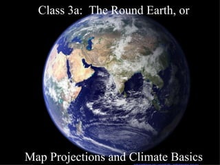
This document discusses key concepts relating to map projections and climate basics. It explains that temperature is determined by factors like insolation, cloud cover, altitude, water vapor, and air movement. It also outlines that the earth's tilt and rotation cause the seasons, and that latitude and longitude are used to locate positions on the globe. Finally, it summarizes different types of map projections, including cylindrical, conic, and planar projections, and notes tradeoffs between accurately representing area, shape, and distance.
Report
Share
Report
Share
![How hot is it? ,[object Object],[object Object],[object Object],[object Object],[object Object],[object Object],[object Object]](data:image/gif;base64,R0lGODlhAQABAIAAAAAAAP///yH5BAEAAAAALAAAAAABAAEAAAIBRAA7)
Recommended
Class3b
The document discusses different topics related to climate and weather:
1) It describes different types of map projections and considerations for how to project a spherical globe onto a flat surface, balancing properties like area, shape, and distance.
2) It explains air pressure and global wind patterns, how warmer air rises at the equator and sinks at 30 degrees latitude, and how this influences ocean currents and precipitation patterns.
3) It introduces the Köppen climate classification system and has students identify climate types and locations that exemplify different climates to understand the factors influencing local climates.
4) It provides a brief overview of hurricanes, noting they start from low pressure centers and release energy through condensation
Models and dimensions of earth
Maps provide pictures of areas and regions that can tell us many things through correct interpretation. The Earth is approximately a sphere, and locations on its surface are commonly described using latitude and longitude, which are angular distances measured from the center. The Earth is most accurately described as an oblate spheroid, flattened at the poles and bulging at the equator. Observation of changes in the altitude of Polaris as one moves north or south provides evidence that the Earth is spherical.
Models of the Earth - Mapping
This document discusses models of the Earth and methods for finding locations on its surface. It explains that the globe is a spherical representation with no top or bottom and uses the Earth's rotation as a reference point. Latitude and longitude are used to specify locations, where latitude is the distance north or south of the equator and longitude is the distance east or west of the prime meridian. Various map projections like Mercator and conic are described which allow depicting the spherical Earth on a flat surface.
Ch 5 View Of Earth Notes
The document provides an overview of landforms, views of Earth, and mapping techniques. It discusses the three main landforms - plains, plateaus, and mountains - and how each forms. It then covers latitude and longitude for determining locations, global time zones, and types of map projections like Mercator and topographic maps using contour lines. Finally, it discusses remote sensing techniques from satellites and underwater to map and study Earth's surface and oceans.
Maps as Models of Earth
This document provides information about key concepts for reading and understanding topographic maps, including:
- Contour lines connect points of equal elevation and are used to show elevation changes on topographic maps. Closer contour lines indicate steeper slopes.
- Relief, elevation difference between highest and lowest points in an area, determines the contour interval or spacing between lines.
- Contour lines have set rules like never crossing, being V-shaped in valleys, and forming closed circles around peaks.
Globe
What is a globe?
Earth's surface
Features of the earth
Equator
Hemispheres
Longitude and Latitudes
Earth Grid
Locating Places on the map/globe
Maps and globes
This document provides information about maps and globes, including their advantages and disadvantages. It explains that globes accurately show the shapes and sizes of landmasses and oceans, while maps represent these on a flat surface, which can distort sizes and distances. The document also defines geographic lines like the equator and prime meridian that divide the globe. It notes different map projections can distort shapes depending on their purpose. Finally, it poses questions about locations of cities and superlatives like largest bodies of water and countries.
Maps And Globes Are Models Of The Earth
1. Maps and globes are models that represent features on Earth's surface. Maps show natural and human features from an above view, while globes show Earth as seen from space with accurate sizes and shapes.
2. Maps use symbols to indicate different land features such as mountains, plateaus, and plains. They also use scales and legends to relate distances on maps to actual distances and explain symbols.
3. Latitude and longitude lines are used to locate positions on Earth, with latitude measuring distances north and south of the equator and longitude measuring distances east and west of the prime meridian.
Cartographic Projections
This document discusses different types of map projections used to represent the spherical Earth on a flat surface. It describes terrestrial globes which do not distort the Earth's surface but are not useful for studying details. It then explains that all map projections inevitably introduce some distortion and describes three main categories of projections - equivalent, equidistant, and conformal - based on how they portray specific characteristics. The rest of the document provides details on cylindrical, conic, and azimuthal/zenithal projection types and their unique properties and distortions.
Map+compass
This document provides instructions for three activities to teach navigation skills using a map and compass:
1) Finding bearings from a map by placing the compass on the map and orienting it along the line between start and finish points.
2) Aiming off to compensate for obstacles like streams or trails by adjusting the bearing 5 degrees before following it to the destination.
3) Understanding declination, the difference between magnetic and grid north, and how to add or subtract degrees to a compass bearing depending on whether declination is east or west. The goal is to avoid following an incorrect route to the intended destination.
Maps and globes power point
This document provides an overview of a third grade unit on maps and globes. Students will develop map skills by positioning and labeling the seven continents and five oceans to create a world map. They will use the equator and prime meridian to identify the four hemispheres and locate specific countries. Students will also read, construct, and interpret maps, tables, graphs and charts. The document reviews key terms like hemisphere, equator, prime meridian and using a grid system to locate places on a map.
Maps as Models of Earth
This document provides an overview of key concepts for understanding topographic maps, including:
- Contour lines connect points of equal elevation and are used to show elevation changes on topographic maps. Contour interval is the difference in elevation between lines.
- Steeper slopes are shown by closer contour line spacing, while more gentle slopes have lines farther apart. Contour lines never cross and have specific shapes depending on terrain features.
- Topographic maps also use symbols, colors, and index contours to represent landforms and elevation information. These maps provide important data for understanding Earth's surface features and elevation.
Presentation1
This document summarizes different types of weather phenomena including air masses, fronts, and high and low pressure systems. It explains that air masses have similar properties and fronts form boundaries between different air masses, often causing stormy weather. It also outlines how cold fronts and warm fronts form as different air masses interact, and how stationary fronts can cause variable weather. Finally, it discusses how meteorologists use weather maps showing symbols for fronts and pressure systems to predict weather patterns.
Pau (2)
Cartography involves making maps and using key geographic concepts like latitude, longitude, and map scale. Latitude ranges from 0 to 90 degrees north and south of the equator, while longitude extends from 0 to 360 degrees east and west of the Greenwich meridian. Map scale relates distances on a map to actual distances on earth. The most relevant lines for latitude and longitude are the equator, tropics, Arctic and Antarctic circles. The major continents are North America, South America, Europe, Africa, Antarctica, Australia, and Asia, with subcontinents including Indian, European, and West Asian regions.
Pau (2)
Cartography is the study and practice of making maps. Latitude measures the location north or south of the equator from 0 to 90 degrees, while longitude measures the location east or west of the prime meridian from 0 to 360 degrees. Map scale defines the ratio of distances on a map to distances on the ground. The document then discusses the relevant measures of latitude and longitude for Earth and identifies the continents and subcontinents.
Pau
Cartography is the study and practice of making maps. Latitude measures the location north or south of the equator from 0 to 90 degrees. Longitude measures the east-west location from 0 to 360 degrees. Map scale is the ratio of distances on a map to distances on the ground. The most relevant measures of latitude and longitude for the Earth are 23.5 degrees north and south of the equator, while longitude ranges from 0 to 180 degrees east and west. The main continents are North America, South America, Europe, Africa, Antarctica, Australia, and Asia, with subcontinents including India, USA, Europe, and the Middle East.
Lab two location and time
The document discusses latitude and longitude, which are used to locate positions on Earth. Latitude lines run horizontally around the globe and indicate how far north or south a place is from the equator. Longitude lines run vertically and indicate how far east or west a place is from the prime meridian in Greenwich, England. Together, a latitude and longitude coordinate precisely locates any place on Earth. The document also discusses time zones and standard time, which were developed to allow for consistent timekeeping across different regions as travel and communication expanded globally.
Latitudes and longitudes
1. A globe is a miniature model of the Earth that shows its true spherical shape and allows locations to be precisely pinpointed using lines of latitude and longitude.
2. The globe can be rotated on its axis and is marked with the Equator, Tropic of Cancer at 23.5° N, Tropic of Capricorn at 23.5° S, and other important parallels of latitude. Meridians of longitude divide the globe into Eastern and Western hemispheres.
3. Locations are specified using their latitude and longitude coordinates - degrees north or south of the Equator, and degrees east or west of the Prime Meridian passing through Greenwich, England. This grid system allows any place
Presentation1
This document summarizes key concepts about weather and climate, including how different weather occurs due to atmospheric motion and how major air masses and the jet stream affect weather across North America. It describes key terms like air masses, fronts, high and low pressure systems, and how weather maps can be used to track these systems and predict future weather conditions.
Chapter1
The document provides an overview of world regional geography, including its key concepts, tools, and objectives. It discusses the branches of geography, the six essential elements studied in geography, and the world regional approach used to examine different parts of the world. It also describes important geographic tools like maps, geographic information systems, and remote sensing technologies.
11 weather forecasting
The document discusses how weather affects daily life and decisions, and what tools meteorologists use to predict weather, including computers, satellites, climatology, and identifying patterns in weather data. Meteorologists can predict weather up to 5 days in advance by interpreting symbols on maps including high and low pressure systems, cloud cover, and the movement of fronts. Forecasting involves analyzing these symbols and conditions shown on weather maps to determine what weather to expect.
Lines of Latitude and Longitude – PowerPoint
PowerPoint on Lines of Latitude, Lines of Longitude, Climate Zones, Equinoxes, Solstices, The Three Norths, Prime Meridian, International Date Line, Greenwich Mean Time, Coordinated Universal Time.
Lines of Latitude and Longitude – Worksheet at:
http://www.slideshare.net/yaryalitsa/lines-of-latitude-and-longitude-worksheet
Weather Basics Notes
Air masses are large bodies of air that take on the characteristics of the area over which they sit. They are classified by their temperature and moisture content as either continental or maritime, and either polar or tropical. Continental air masses are dry while maritime are wet. Polar air masses are cold and tropical are warm. Fronts occur at boundaries between air masses and can cause precipitation, particularly cold fronts which involve cold air wedging under warm air. Warm fronts occur when warm air advances, replacing cold air over a large area.
Location and time
The document discusses the concepts of latitude, longitude, time zones, and how locations on Earth are specified using these coordinate systems. It explains that latitude lines run parallel east-west and longitude lines run perpendicular north-south, with the Prime Meridian at Greenwich, England defining 0 degrees. It describes how the Earth is divided into 24 time zones that are approximately 15 degrees wide to standardized time globally.
Unit 1 mapping
This document provides information about latitude and longitude, different map projections, topographic maps, and remote sensing. It defines key terms and concepts and describes how cartographers use lines of latitude and longitude to locate positions on Earth. It also explains how different map projections, such as Mercator and conic, represent the globe on a flat surface and how topographic maps use contour lines to show elevation changes. The document concludes by discussing how satellites, sonar, and GPS are used in remote sensing to map and study Earth's surface and oceans from a distance.
Forecasting the weather powerpoint
This document discusses weather forecasting and understanding weather maps. It explains that weather maps show isobars which indicate wind patterns around high and low pressure systems. Closer isobars mean stronger winds. It describes features of high and low pressure systems including wind direction. Cold fronts are shown where cold air pushes warm air upwards, potentially causing rain. Mechanisms that can trigger rain include fronts, low pressure systems, hills and turbulence. Clouds alone do not guarantee rain as clouds need sufficient moisture and lifting of air to produce meaningful rainfall.
Longitude time and ist 1
The document discusses longitudes and how they are used to precisely locate places on Earth. [1] Longitudes are lines that run north-south and are measured in degrees east or west from the Prime Meridian, which passes through Greenwich, England. [2] Unlike parallels of latitude, all meridians of longitude are equal in length. [3] Standard time zones were established because the local solar time differs across longitudes, making coordination of schedules like train timetables difficult without standardization.
The Globe And It's Features
This document provides information about the globe and its features, including:
- The earliest known globe was constructed by Greek geographer Crates of Mallus.
- Cartographers use lines of latitude and longitude to locate points on Earth, with the equator and prime meridian serving as reference points.
- Latitude circles the globe parallel to the equator, while longitude runs perpendicular in semicircles.
- Time zones, of which there are 24, divide Earth according to longitude into standardized times.
- The seven continents are listed in order of size from Asia to Antarctica. Four main oceans are also named.
Science On A Sphere
Spherical projection technology at Oregon Museum of Science & Industry. Developed at NOAA, this PPT reviews spherical projection for WhereCamp Portland, October, 2009
World map projections
This document discusses different map projections and their effects on representing sizes and distances accurately. It compares the sizes of Greenland and Africa on the Mercator and Robinson projections, showing that Greenland appears larger than Africa on Mercator when in fact Africa's actual size is over 14 times larger than Greenland. Other map projections like Goode's projection attempt to address the distortions of size introduced by different ways of projecting a 3D globe onto a 2D surface.
More Related Content
What's hot
Cartographic Projections
This document discusses different types of map projections used to represent the spherical Earth on a flat surface. It describes terrestrial globes which do not distort the Earth's surface but are not useful for studying details. It then explains that all map projections inevitably introduce some distortion and describes three main categories of projections - equivalent, equidistant, and conformal - based on how they portray specific characteristics. The rest of the document provides details on cylindrical, conic, and azimuthal/zenithal projection types and their unique properties and distortions.
Map+compass
This document provides instructions for three activities to teach navigation skills using a map and compass:
1) Finding bearings from a map by placing the compass on the map and orienting it along the line between start and finish points.
2) Aiming off to compensate for obstacles like streams or trails by adjusting the bearing 5 degrees before following it to the destination.
3) Understanding declination, the difference between magnetic and grid north, and how to add or subtract degrees to a compass bearing depending on whether declination is east or west. The goal is to avoid following an incorrect route to the intended destination.
Maps and globes power point
This document provides an overview of a third grade unit on maps and globes. Students will develop map skills by positioning and labeling the seven continents and five oceans to create a world map. They will use the equator and prime meridian to identify the four hemispheres and locate specific countries. Students will also read, construct, and interpret maps, tables, graphs and charts. The document reviews key terms like hemisphere, equator, prime meridian and using a grid system to locate places on a map.
Maps as Models of Earth
This document provides an overview of key concepts for understanding topographic maps, including:
- Contour lines connect points of equal elevation and are used to show elevation changes on topographic maps. Contour interval is the difference in elevation between lines.
- Steeper slopes are shown by closer contour line spacing, while more gentle slopes have lines farther apart. Contour lines never cross and have specific shapes depending on terrain features.
- Topographic maps also use symbols, colors, and index contours to represent landforms and elevation information. These maps provide important data for understanding Earth's surface features and elevation.
Presentation1
This document summarizes different types of weather phenomena including air masses, fronts, and high and low pressure systems. It explains that air masses have similar properties and fronts form boundaries between different air masses, often causing stormy weather. It also outlines how cold fronts and warm fronts form as different air masses interact, and how stationary fronts can cause variable weather. Finally, it discusses how meteorologists use weather maps showing symbols for fronts and pressure systems to predict weather patterns.
Pau (2)
Cartography involves making maps and using key geographic concepts like latitude, longitude, and map scale. Latitude ranges from 0 to 90 degrees north and south of the equator, while longitude extends from 0 to 360 degrees east and west of the Greenwich meridian. Map scale relates distances on a map to actual distances on earth. The most relevant lines for latitude and longitude are the equator, tropics, Arctic and Antarctic circles. The major continents are North America, South America, Europe, Africa, Antarctica, Australia, and Asia, with subcontinents including Indian, European, and West Asian regions.
Pau (2)
Cartography is the study and practice of making maps. Latitude measures the location north or south of the equator from 0 to 90 degrees, while longitude measures the location east or west of the prime meridian from 0 to 360 degrees. Map scale defines the ratio of distances on a map to distances on the ground. The document then discusses the relevant measures of latitude and longitude for Earth and identifies the continents and subcontinents.
Pau
Cartography is the study and practice of making maps. Latitude measures the location north or south of the equator from 0 to 90 degrees. Longitude measures the east-west location from 0 to 360 degrees. Map scale is the ratio of distances on a map to distances on the ground. The most relevant measures of latitude and longitude for the Earth are 23.5 degrees north and south of the equator, while longitude ranges from 0 to 180 degrees east and west. The main continents are North America, South America, Europe, Africa, Antarctica, Australia, and Asia, with subcontinents including India, USA, Europe, and the Middle East.
Lab two location and time
The document discusses latitude and longitude, which are used to locate positions on Earth. Latitude lines run horizontally around the globe and indicate how far north or south a place is from the equator. Longitude lines run vertically and indicate how far east or west a place is from the prime meridian in Greenwich, England. Together, a latitude and longitude coordinate precisely locates any place on Earth. The document also discusses time zones and standard time, which were developed to allow for consistent timekeeping across different regions as travel and communication expanded globally.
Latitudes and longitudes
1. A globe is a miniature model of the Earth that shows its true spherical shape and allows locations to be precisely pinpointed using lines of latitude and longitude.
2. The globe can be rotated on its axis and is marked with the Equator, Tropic of Cancer at 23.5° N, Tropic of Capricorn at 23.5° S, and other important parallels of latitude. Meridians of longitude divide the globe into Eastern and Western hemispheres.
3. Locations are specified using their latitude and longitude coordinates - degrees north or south of the Equator, and degrees east or west of the Prime Meridian passing through Greenwich, England. This grid system allows any place
Presentation1
This document summarizes key concepts about weather and climate, including how different weather occurs due to atmospheric motion and how major air masses and the jet stream affect weather across North America. It describes key terms like air masses, fronts, high and low pressure systems, and how weather maps can be used to track these systems and predict future weather conditions.
Chapter1
The document provides an overview of world regional geography, including its key concepts, tools, and objectives. It discusses the branches of geography, the six essential elements studied in geography, and the world regional approach used to examine different parts of the world. It also describes important geographic tools like maps, geographic information systems, and remote sensing technologies.
11 weather forecasting
The document discusses how weather affects daily life and decisions, and what tools meteorologists use to predict weather, including computers, satellites, climatology, and identifying patterns in weather data. Meteorologists can predict weather up to 5 days in advance by interpreting symbols on maps including high and low pressure systems, cloud cover, and the movement of fronts. Forecasting involves analyzing these symbols and conditions shown on weather maps to determine what weather to expect.
Lines of Latitude and Longitude – PowerPoint
PowerPoint on Lines of Latitude, Lines of Longitude, Climate Zones, Equinoxes, Solstices, The Three Norths, Prime Meridian, International Date Line, Greenwich Mean Time, Coordinated Universal Time.
Lines of Latitude and Longitude – Worksheet at:
http://www.slideshare.net/yaryalitsa/lines-of-latitude-and-longitude-worksheet
Weather Basics Notes
Air masses are large bodies of air that take on the characteristics of the area over which they sit. They are classified by their temperature and moisture content as either continental or maritime, and either polar or tropical. Continental air masses are dry while maritime are wet. Polar air masses are cold and tropical are warm. Fronts occur at boundaries between air masses and can cause precipitation, particularly cold fronts which involve cold air wedging under warm air. Warm fronts occur when warm air advances, replacing cold air over a large area.
Location and time
The document discusses the concepts of latitude, longitude, time zones, and how locations on Earth are specified using these coordinate systems. It explains that latitude lines run parallel east-west and longitude lines run perpendicular north-south, with the Prime Meridian at Greenwich, England defining 0 degrees. It describes how the Earth is divided into 24 time zones that are approximately 15 degrees wide to standardized time globally.
Unit 1 mapping
This document provides information about latitude and longitude, different map projections, topographic maps, and remote sensing. It defines key terms and concepts and describes how cartographers use lines of latitude and longitude to locate positions on Earth. It also explains how different map projections, such as Mercator and conic, represent the globe on a flat surface and how topographic maps use contour lines to show elevation changes. The document concludes by discussing how satellites, sonar, and GPS are used in remote sensing to map and study Earth's surface and oceans from a distance.
Forecasting the weather powerpoint
This document discusses weather forecasting and understanding weather maps. It explains that weather maps show isobars which indicate wind patterns around high and low pressure systems. Closer isobars mean stronger winds. It describes features of high and low pressure systems including wind direction. Cold fronts are shown where cold air pushes warm air upwards, potentially causing rain. Mechanisms that can trigger rain include fronts, low pressure systems, hills and turbulence. Clouds alone do not guarantee rain as clouds need sufficient moisture and lifting of air to produce meaningful rainfall.
Longitude time and ist 1
The document discusses longitudes and how they are used to precisely locate places on Earth. [1] Longitudes are lines that run north-south and are measured in degrees east or west from the Prime Meridian, which passes through Greenwich, England. [2] Unlike parallels of latitude, all meridians of longitude are equal in length. [3] Standard time zones were established because the local solar time differs across longitudes, making coordination of schedules like train timetables difficult without standardization.
The Globe And It's Features
This document provides information about the globe and its features, including:
- The earliest known globe was constructed by Greek geographer Crates of Mallus.
- Cartographers use lines of latitude and longitude to locate points on Earth, with the equator and prime meridian serving as reference points.
- Latitude circles the globe parallel to the equator, while longitude runs perpendicular in semicircles.
- Time zones, of which there are 24, divide Earth according to longitude into standardized times.
- The seven continents are listed in order of size from Asia to Antarctica. Four main oceans are also named.
What's hot (20)
Viewers also liked
Science On A Sphere
Spherical projection technology at Oregon Museum of Science & Industry. Developed at NOAA, this PPT reviews spherical projection for WhereCamp Portland, October, 2009
World map projections
This document discusses different map projections and their effects on representing sizes and distances accurately. It compares the sizes of Greenland and Africa on the Mercator and Robinson projections, showing that Greenland appears larger than Africa on Mercator when in fact Africa's actual size is over 14 times larger than Greenland. Other map projections like Goode's projection attempt to address the distortions of size introduced by different ways of projecting a 3D globe onto a 2D surface.
Map_Projections
This document discusses map projections and coordinate systems in GIS. It explains that there are two main types of coordinate systems: geographic and projected. Geographic coordinate systems use spherical coordinates to identify Earth surface features, while projected coordinate systems use planar coordinates to identify features by projecting them onto a flat surface. It also discusses datums, which provide a reference framework for measuring locations on the Earth's surface, as well as how map projections introduce distortions like changes to shape, area, distance and direction when converting from a spherical to planar surface.
Maps
This document provides an overview of maps and map projections for web developers. It discusses common map projections like Mercator and UTM, how to represent latitude and longitude, tools for working with maps like Proj4 and GDAL, popular map providers like Google Maps, Bing Maps and OpenStreetMap, and how to create your own map server using tools like Mapnik, PostGIS, and tile rendering.
00 charlton map_projections
The document discusses maps and map projections. It provides information on different types of map projections like cylindrical, conic, and planar projections. It explains key concepts like latitude, longitude, datums, and how different projections distort shapes and distances in different ways in order to portray the spherical Earth on a flat surface. No single projection can preserve all geometric properties.
Chapter 2:3 Maps
Maps are used to locate places and show distributions of features on Earth's surface. There are different types of map projections that show shapes and sizes of landmasses in different ways. Topographic maps model elevation changes using contour lines and indicate natural and human-made features. Geologic maps show the arrangement and types of rocks at the surface and below.
Map skills – measuring distance and using a
This document explains how to use a map scale to measure distances. It provides instructions on using a ruler or piece of paper to follow a route on a map and measure the distance in centimeters. The distance must then be converted to kilometers using the scale ratio shown on the map. Examples are given of measuring distances between various locations in New Zealand.
Map Projections
The document discusses different types of map projections used to represent the spherical Earth on a flat surface. It describes distortions inherent in all flat map projections and highlights several specific projections including the Mercator, interrupted, Peters, Robinson projections. The key point is that no single projection is perfect and mapmakers must choose one best suited to their specific needs, minimizing important distortions.
Geography Skills
There are several types of map projections that are used to represent the spherical Earth on a flat surface. All map projections involve some degree of distortion of shapes, sizes, or distances. The Mercator projection increasingly distorts distances the farther one moves from the equator, while the Robinson and Goode's interrupted projections aim to minimize distortion of landmasses. Other map features discussed include hemispheres, latitude and longitude grid systems, directions, scales, and different types of thematic maps.
Open data initiatives
This document discusses open data and open source initiatives in the Philippines. It begins with a disclaimer from the author Maning Sambale about his perspectives. It then discusses concepts like open data, free culture movements, open source software, open formats, and free content. Examples of open initiatives in the Philippines are provided like OpenStreetMap and Project NOAH. The document ends with excuses people give for not sharing data openly and messages from users of open mapping data in the Philippines.
Projections Eps
This document discusses map projections and coordinate systems. It begins with a review of ellipsoids and datums that are used to approximate the shape of the Earth. It then discusses different types of map projections used to transform the spherical Earth onto a flat surface with minimal distortion. Finally, it reviews different coordinate systems and examples of horizontal and vertical datums.
Map scale and projection
This document discusses map scale and projections. It defines scale as the relationship between distances on a map and in reality. Scale can be indicated graphically using a bar scale or fractionally as a ratio. Larger scale maps show smaller areas in greater detail while smaller scale maps show larger areas with less detail. Map projections transfer the spherical Earth onto a flat surface, inevitably introducing some distortion of shapes, sizes or distances. Different projections prioritize conformality, equivalence or other properties depending on the map's intended use.
Introduction to MAPS,Coordinate System and Projection System
This document discusses key concepts in GIS including maps, coordinate systems, map projections, and their application in Nepal. It defines analog and digital maps, and explains that the earth is an ellipsoid rather than a perfect sphere. It introduces geographic and rectangular coordinate systems, and defines map projections as methods to represent the curved earth on a flat surface. The document outlines the Everest ellipsoid and UTM/MUTM projection systems used in Nepal.
map projections
This document summarizes a lesson on map projections. It begins with asking students to discuss differences between maps and the meaning of "projection." It then outlines the agenda which includes learning about map making problems, types of projections, and focusing on the Mercator projection. The objectives are for students to learn about different map projections. Types of projections discussed include cylindrical, conic, plane and interrupted projections. Specific projections like Mercator and Gall-Peters are also covered.
Map projections
This document discusses map projections and their properties. Map projections transform the three-dimensional globe onto a two-dimensional surface, necessarily introducing some distortions. The best projection depends on the map's purpose and region. Common projections include cylindrical (like Mercator), conic, and planar/polar types. Key properties that projections aim to preserve, like shape, area, distance and direction, often involve tradeoffs. Choosing a projection minimizes distortions for a map's intended use and geographic extent.
Viewers also liked (15)
Introduction to MAPS,Coordinate System and Projection System
Introduction to MAPS,Coordinate System and Projection System
Similar to Maps
Coordinate systems
The document discusses geographic coordinate systems (GCS) and projected coordinate systems (PCS). It explains that a GCS uses latitude and longitude to define locations on Earth based on the equator and prime meridian. A PCS projects locations onto a flat surface using x,y coordinates defined by a grid. It also discusses datums, which define ellipsoids and their position relative to Earth's center, providing a reference frame. Map projections transform locations from the ellipsoid to the flat grid using mathematical formulas that can distort shapes, areas, or distances.
Coordinate System.pdf
The document discusses coordinate systems and geo-referencing. It describes geographic coordinate systems (GCS) which use latitude and longitude based on an ellipsoid and datum. It also describes projected coordinate systems (PCS) which use x,y coordinates on a flat plane for mapping purposes. The document outlines how different map projections transform the ellipsoid to the flat plane, introducing various types of distortion. It emphasizes the importance of coordinate systems and transformations for accurately locating points on maps and overlaying spatial data.
ch5-georeferencing.ppt
This document provides an overview of different methods of georeferencing, or assigning locations to information on maps. It discusses various systems like placenames, addresses, postcodes, cadastral maps, and coordinate systems. Latitude and longitude provide a comprehensive global standard, but distortions require map projections like UTM for GIS. GPS allows direct measurement of coordinates with increasing accuracy from basic to differential systems. Georeferences must be unique, shared, and persistent over time to be useful references in maps and spatial analysis.
Surveying geodesy ajith sir
The Earth is not a perfect sphere, but is slightly flattened at the poles. The Earth rotates daily on its tilted axis, causing seasons and influencing climate. Parallels of latitude and meridians of longitude form a grid system to locate positions on the Earth's surface. The Earth revolves around the Sun annually in an elliptical orbit, with the seasons resulting from the tilt of its axis of rotation. Precise geodetic coordinates define locations on the reference ellipsoid used to model the oblate spheroid shape of the Earth.
2_Earth_and_its_coordinates.ppt
The document describes the Earth's coordinate system of latitude and longitude. It defines key terms like the equator, which divides the Earth into northern and southern hemispheres. Latitude is the angular distance north or south of the equator, while longitude is the angular distance east or west of the prime meridian. Together, latitude and longitude provide a framework for precisely locating any position on Earth.
Unit 1 - Earth in space
The document summarizes key information about planet Earth and its place in the solar system. It describes Earth's structure, including the atmosphere, hydrosphere, and lithosphere. It also discusses Earth's rotation and revolution around the sun, which causes seasons. The document explains how to locate places using latitude and longitude coordinates on maps and read different types of maps. It provides details on time zones and how the Earth is divided for time.
What is Latitude and Longhitude and How it affects the Weather.pptx
Latitude and Longhitude are invisible lines
Prime Meridian,Equator, Latitude and longitude
This document defines and explains key concepts related to latitude, longitude, and their use in determining locations on Earth. It discusses the prime meridian, equator, latitude, longitude, north and south latitudes, east and west longitudes, and the international date line. Latitude lines run parallel around the globe, measuring angles north and south of the equator, while longitude lines converge at the poles, measuring angles east and west of the prime meridian. Together, latitude and longitude precisely locate positions worldwide.
Globe & latitude 1
CBSE NCERT SOCIAL SCIENCE HISTORY GEOGRAPHY POLITICAL SCIENCE ECONOMICS CLASS 6,9 AND 11 CHAPTER LATITUDES AND LONGFITUDES
Latitude and longitude for Demo.pptx
Quarter 4, module 1. Its about latitude and longitude. in this lesson, we are going to identify the location of the earth.
LATITUDE.powerpoint presention documents
This powerful PowerPoint presentation is made by a graduating student that pushes her study even more because she believe that while doing something she loves, it can be easy for them to study and to strive even more for their studies
Latitude
Latitude is a geographic coordinate that specifies the north-south position of a point on the Earth's surface. Lines of constant latitude, or parallels, run east-west as circles parallel to the equator. Latitude ranges from 0° at the Equator to 90° (North or South) at the poles. Latitude is used together with longitude to specify the precise location of features on the Earth's surface. The document discusses how latitude is defined on both a spherical model of the Earth as well as a more accurate ellipsoidal model.
Science 4th
1. The International Date Line is an imaginary line that runs through the Pacific Ocean near 180° longitude, separating calendar dates.
2. It is not a perfectly straight line and bends in some areas, like near Kiribati, to keep countries and territories within the same date.
3. Crossing the date line from east to west adds a day to the calendar date, while crossing from west to east subtracts a day. This maintains a consistent calendar around the globe.
NS2 3.3 Wind and Weather
The document discusses different types of winds and weather patterns around the world. It explains how uneven heating of the Earth's surface causes atmospheric pressure differences that drive global wind patterns, including the trade winds, prevailing westerlies, and polar easterlies. It also describes local winds like monsoons and mountain winds, and how features like ocean currents and landforms can influence regional weather conditions.
Geographical Themes and Terms
This document provides an overview of key geographic concepts and terms. It discusses different map projections like the Mercator, Goode, and Robinson projections. It also defines important location systems like latitude, longitude, and hemispheres. Additionally, it outlines features found on maps like legends, scale bars, and contour lines. Finally, it defines geographic entities like continents, oceans, and different types of maps.
_L-14 The Globe- Latitudes and Longitudes new.pptx
Here are the answers:
1. The local time of a place situated 60° W of London will be 6 pm if it is noon in London. Since each 15° of longitude represents a 1 hour time difference, and the place is 60° west of London, the time difference will be 60/15 = 4 hours. So if it is noon in London, the local time at the place 60° W will be noon + 4 hours = 6 pm.
2. The local time of a place situated 90° E of London will be 3 pm if it is 9 am in London. Since each 15° of longitude represents a 1 hour time difference, and the place is 90° east of London, the time difference will be
Location and time
The document discusses the history and development of latitude, longitude, and timekeeping systems. It explains that latitude and longitude were developed in the Middle Ages to create a global grid system for location. It then provides details on latitude and longitude lines and degrees, and how they are used to precisely locate places on Earth. The document also outlines the development of standardized time zones to facilitate global communication and travel, and covers the establishment of the Prime Meridian, International Date Line, and daylight saving time.
Aerial NAVIGATION and FLIGHT PLANNING.pptx
Air navigation for BS aviation
undergraduate programme . This ppt explains basic concepts of air navigation. this is used to teach BS aviation, undergrad
Unit1 160131210057
1. The document discusses the structure and content of a unit on planet Earth and its representation. It will cover topics like the shape and movements of the Earth, coordinates, maps, and time zones.
2. Key concepts that will be explained include the rotation and revolution of the Earth, latitude and longitude, map projections that represent the spherical Earth on a flat surface, and different types of maps and scales.
3. Questions to be answered relate to the position of Earth in the solar system, its movements and seasons, geographic coordinates, representations of Earth, and defining features of maps like scale and time zones. Useful vocabulary is also provided.
Similar to Maps (20)
What is Latitude and Longhitude and How it affects the Weather.pptx
What is Latitude and Longhitude and How it affects the Weather.pptx
Beige Brown Vintage Group Project Presentation.pdf
Beige Brown Vintage Group Project Presentation.pdf
_L-14 The Globe- Latitudes and Longitudes new.pptx
_L-14 The Globe- Latitudes and Longitudes new.pptx
More from Renee Henderson
Discovery Education Taking a Closer Look
This document discusses Prince George's County Public School's transition to digital learning. It notes that the school system has a 1:1 staff computer to 3:1 student computer ratio. The primary goal is to ensure students graduate college and career ready by developing 21st century skills through digital media and environments, as outlined by ISTE standards and aligned with Common Core standards. It emphasizes using multiple media and tools for communication, composition, and showing knowledge. The document promotes engaging and transforming students to achieve academic excellence through lifelong learning and discovery, with the goal of having a technology training team and "DEN Star" in every school.
Parent Newsletter
This newsletter provides information about upcoming events and assignments for the 3rd grade class of Ms. Mayo at Esther M. Sutton Academy. It includes details about science, math, and social studies lessons for the week, as well as reminders about bringing money for a field trip lunch and an umbrella. It also lists this week's homework assignments, highlights such as a classroom open house and ice cream social, and an upcoming school assembly where students can dress as storybook characters.
Hobson Back To School Newsletter
This newsletter welcomes students and parents to Ms. Hobson's 3rd grade class. It provides information about communicating with parents through Google groups, a class newsletter, and homework folders. It emphasizes developing critical thinking, understanding, creativity and respect. It also discusses the MSA standardized test, bullying prevention, required school supplies, grading through an online system, and promoting family nights.
Porttowns
The document provides information for parents on how to help their children at home, including:
1) Giving encouragement when children complete tasks and assignments, talking about their school day, and allowing creative exploration with materials.
2) The document also outlines classroom rules and behavior expectations, homework policies, and contact information for the 5th grade teacher. Parents are encouraged to communicate with the teacher via email, phone or conferences.
3) The homework is expected to take 45-60 minutes daily and include reading, language arts, spelling, math, social studies and science. Parents should check and initial completed homework.
Back to school Newsletter J Henderson
The newsletter welcomes parents and caregivers to a new school year at Sunshine Elementary. It emphasizes the importance of school-teacher-parent communication and encourages parents to support their children's education at home. The document also provides information about instructional strategies, joining the PTA, and the classroom schedule, which includes centers for different skills and activities related to students' individual education plans. The principal looks forward to working with students, parents, and volunteers to achieve academic success.
Back To School Newsletter
Ms. Phillip introduces herself as the first grade teacher for the upcoming school year. She outlines some of the core subjects that will be taught like math, reading, science, and social studies. She also discusses classroom policies regarding homework, behavior charts, and contact information for parents. The overall message is one of welcome and setting expectations for a productive year of learning.
Standard 2B
The document outlines a lesson plan for teaching students about technology. It involves having students share what they already know, watching a movie to learn new terms, and doing exercises in groups to create and share a PowerPoint and email autobiography of an inventor. For homework, students will create a Voki and for a test they will create a biography, email it, and do a Voki about themselves within 30 minutes in the computer lab.
2009 Portfolio
Talecia Stephens shares her journey to becoming an effective educator through her experiences teaching pre-K and 3-year-olds. She gained knowledge of subject matter and effective teaching strategies through her academic studies and field experiences. She utilized technology, multiple assessments, and a multicultural perspective in her lessons. She also gained experience teaching special populations. Her reflective practice and positive relationships with students, parents, and colleagues helped strengthen her skills. Her future plans are to continue her education and teaching career.
Final Step Wiki Ppt
The document discusses setting up and using wikis in the classroom. It provides an agenda for a workshop on wikis including an introduction to wikis, requirements for classroom wikis, dos and don'ts of using wikis, examples of wikis, and how to create a classroom wiki. It also includes a warm-up quiz about wikis.
Final Step Wiki Ppt
The document discusses setting up and using wikis in the classroom. It provides an agenda for a workshop on wikis including an introduction to wikis, requirements for classroom wikis, dos and don'ts of using wikis, examples of wikis, and how to create a classroom wiki. It also includes examples of widgets that can be added to wikis and how discussion boards and student access can be set up.
Technology Literacy Project Micca 110508
The document discusses Maryland's plans to measure technology literacy among students, teachers, and administrators. It describes the development of the Maryland Measure of Student Technology Literacy (MMSTL) to assess all 7th grade students, and technology literacy inventories for teachers and administrators based on state standards. All instruments will be administered online in spring 2009 to provide baseline data and inform professional development needs to achieve technology goals.
Document Camera in Science Class
The document discusses using document cameras for science instruction. It describes how document cameras allow students to view microscope images of onion root tips in mitosis, observe heart dissections when there are not enough organs for the whole class, view student-created atomic models of elements to take photos for a class PowerPoint, and identify plant parts and label diagrams at their desks while viewing specimens under the document camera.
More from Renee Henderson (12)
Recently uploaded
Communications Mining Series - Zero to Hero - Session 1
This session provides introduction to UiPath Communication Mining, importance and platform overview. You will acquire a good understand of the phases in Communication Mining as we go over the platform with you. Topics covered:
• Communication Mining Overview
• Why is it important?
• How can it help today’s business and the benefits
• Phases in Communication Mining
• Demo on Platform overview
• Q/A
Climate Impact of Software Testing at Nordic Testing Days
My slides at Nordic Testing Days 6.6.2024
Climate impact / sustainability of software testing discussed on the talk. ICT and testing must carry their part of global responsibility to help with the climat warming. We can minimize the carbon footprint but we can also have a carbon handprint, a positive impact on the climate. Quality characteristics can be added with sustainability, and then measured continuously. Test environments can be used less, and in smaller scale and on demand. Test techniques can be used in optimizing or minimizing number of tests. Test automation can be used to speed up testing.
“I’m still / I’m still / Chaining from the Block”
“An Outlook of the Ongoing and Future Relationship between Blockchain Technologies and Process-aware Information Systems.” Invited talk at the joint workshop on Blockchain for Information Systems (BC4IS) and Blockchain for Trusted Data Sharing (B4TDS), co-located with with the 36th International Conference on Advanced Information Systems Engineering (CAiSE), 3 June 2024, Limassol, Cyprus.
UiPath Test Automation using UiPath Test Suite series, part 6
Welcome to UiPath Test Automation using UiPath Test Suite series part 6. In this session, we will cover Test Automation with generative AI and Open AI.
UiPath Test Automation with generative AI and Open AI webinar offers an in-depth exploration of leveraging cutting-edge technologies for test automation within the UiPath platform. Attendees will delve into the integration of generative AI, a test automation solution, with Open AI advanced natural language processing capabilities.
Throughout the session, participants will discover how this synergy empowers testers to automate repetitive tasks, enhance testing accuracy, and expedite the software testing life cycle. Topics covered include the seamless integration process, practical use cases, and the benefits of harnessing AI-driven automation for UiPath testing initiatives. By attending this webinar, testers, and automation professionals can gain valuable insights into harnessing the power of AI to optimize their test automation workflows within the UiPath ecosystem, ultimately driving efficiency and quality in software development processes.
What will you get from this session?
1. Insights into integrating generative AI.
2. Understanding how this integration enhances test automation within the UiPath platform
3. Practical demonstrations
4. Exploration of real-world use cases illustrating the benefits of AI-driven test automation for UiPath
Topics covered:
What is generative AI
Test Automation with generative AI and Open AI.
UiPath integration with generative AI
Speaker:
Deepak Rai, Automation Practice Lead, Boundaryless Group and UiPath MVP
A tale of scale & speed: How the US Navy is enabling software delivery from l...
Rapid and secure feature delivery is a goal across every application team and every branch of the DoD. The Navy’s DevSecOps platform, Party Barge, has achieved:
- Reduction in onboarding time from 5 weeks to 1 day
- Improved developer experience and productivity through actionable findings and reduction of false positives
- Maintenance of superior security standards and inherent policy enforcement with Authorization to Operate (ATO)
Development teams can ship efficiently and ensure applications are cyber ready for Navy Authorizing Officials (AOs). In this webinar, Sigma Defense and Anchore will give attendees a look behind the scenes and demo secure pipeline automation and security artifacts that speed up application ATO and time to production.
We will cover:
- How to remove silos in DevSecOps
- How to build efficient development pipeline roles and component templates
- How to deliver security artifacts that matter for ATO’s (SBOMs, vulnerability reports, and policy evidence)
- How to streamline operations with automated policy checks on container images
20 Comprehensive Checklist of Designing and Developing a Website
Dive into the world of Website Designing and Developing with Pixlogix! Looking to create a stunning online presence? Look no further! Our comprehensive checklist covers everything you need to know to craft a website that stands out. From user-friendly design to seamless functionality, we've got you covered. Don't miss out on this invaluable resource! Check out our checklist now at Pixlogix and start your journey towards a captivating online presence today.
Alt. GDG Cloud Southlake #33: Boule & Rebala: Effective AppSec in SDLC using ...
Effective Application Security in Software Delivery lifecycle using Deployment Firewall and DBOM
The modern software delivery process (or the CI/CD process) includes many tools, distributed teams, open-source code, and cloud platforms. Constant focus on speed to release software to market, along with the traditional slow and manual security checks has caused gaps in continuous security as an important piece in the software supply chain. Today organizations feel more susceptible to external and internal cyber threats due to the vast attack surface in their applications supply chain and the lack of end-to-end governance and risk management.
The software team must secure its software delivery process to avoid vulnerability and security breaches. This needs to be achieved with existing tool chains and without extensive rework of the delivery processes. This talk will present strategies and techniques for providing visibility into the true risk of the existing vulnerabilities, preventing the introduction of security issues in the software, resolving vulnerabilities in production environments quickly, and capturing the deployment bill of materials (DBOM).
Speakers:
Bob Boule
Robert Boule is a technology enthusiast with PASSION for technology and making things work along with a knack for helping others understand how things work. He comes with around 20 years of solution engineering experience in application security, software continuous delivery, and SaaS platforms. He is known for his dynamic presentations in CI/CD and application security integrated in software delivery lifecycle.
Gopinath Rebala
Gopinath Rebala is the CTO of OpsMx, where he has overall responsibility for the machine learning and data processing architectures for Secure Software Delivery. Gopi also has a strong connection with our customers, leading design and architecture for strategic implementations. Gopi is a frequent speaker and well-known leader in continuous delivery and integrating security into software delivery.
GraphSummit Singapore | The Future of Agility: Supercharging Digital Transfor...
Leonard Jayamohan, Partner & Generative AI Lead, Deloitte
This keynote will reveal how Deloitte leverages Neo4j’s graph power for groundbreaking digital twin solutions, achieving a staggering 100x performance boost. Discover the essential role knowledge graphs play in successful generative AI implementations. Plus, get an exclusive look at an innovative Neo4j + Generative AI solution Deloitte is developing in-house.
Removing Uninteresting Bytes in Software Fuzzing
Imagine a world where software fuzzing, the process of mutating bytes in test seeds to uncover hidden and erroneous program behaviors, becomes faster and more effective. A lot depends on the initial seeds, which can significantly dictate the trajectory of a fuzzing campaign, particularly in terms of how long it takes to uncover interesting behaviour in your code. We introduce DIAR, a technique designed to speedup fuzzing campaigns by pinpointing and eliminating those uninteresting bytes in the seeds. Picture this: instead of wasting valuable resources on meaningless mutations in large, bloated seeds, DIAR removes the unnecessary bytes, streamlining the entire process.
In this work, we equipped AFL, a popular fuzzer, with DIAR and examined two critical Linux libraries -- Libxml's xmllint, a tool for parsing xml documents, and Binutil's readelf, an essential debugging and security analysis command-line tool used to display detailed information about ELF (Executable and Linkable Format). Our preliminary results show that AFL+DIAR does not only discover new paths more quickly but also achieves higher coverage overall. This work thus showcases how starting with lean and optimized seeds can lead to faster, more comprehensive fuzzing campaigns -- and DIAR helps you find such seeds.
- These are slides of the talk given at IEEE International Conference on Software Testing Verification and Validation Workshop, ICSTW 2022.
Full-RAG: A modern architecture for hyper-personalization
Mike Del Balso, CEO & Co-Founder at Tecton, presents "Full RAG," a novel approach to AI recommendation systems, aiming to push beyond the limitations of traditional models through a deep integration of contextual insights and real-time data, leveraging the Retrieval-Augmented Generation architecture. This talk will outline Full RAG's potential to significantly enhance personalization, address engineering challenges such as data management and model training, and introduce data enrichment with reranking as a key solution. Attendees will gain crucial insights into the importance of hyperpersonalization in AI, the capabilities of Full RAG for advanced personalization, and strategies for managing complex data integrations for deploying cutting-edge AI solutions.
TrustArc Webinar - 2024 Global Privacy Survey
How does your privacy program stack up against your peers? What challenges are privacy teams tackling and prioritizing in 2024?
In the fifth annual Global Privacy Benchmarks Survey, we asked over 1,800 global privacy professionals and business executives to share their perspectives on the current state of privacy inside and outside of their organizations. This year’s report focused on emerging areas of importance for privacy and compliance professionals, including considerations and implications of Artificial Intelligence (AI) technologies, building brand trust, and different approaches for achieving higher privacy competence scores.
See how organizational priorities and strategic approaches to data security and privacy are evolving around the globe.
This webinar will review:
- The top 10 privacy insights from the fifth annual Global Privacy Benchmarks Survey
- The top challenges for privacy leaders, practitioners, and organizations in 2024
- Key themes to consider in developing and maintaining your privacy program
Mind map of terminologies used in context of Generative AI
Mind map of common terms used in context of Generative AI.
20240605 QFM017 Machine Intelligence Reading List May 2024
Everything I found interesting about machines behaving intelligently during May 2024
Building RAG with self-deployed Milvus vector database and Snowpark Container...
This talk will give hands-on advice on building RAG applications with an open-source Milvus database deployed as a docker container. We will also introduce the integration of Milvus with Snowpark Container Services.
“Building and Scaling AI Applications with the Nx AI Manager,” a Presentation...
“Building and Scaling AI Applications with the Nx AI Manager,” a Presentation...Edge AI and Vision Alliance
For the full video of this presentation, please visit: https://www.edge-ai-vision.com/2024/06/building-and-scaling-ai-applications-with-the-nx-ai-manager-a-presentation-from-network-optix/
Robin van Emden, Senior Director of Data Science at Network Optix, presents the “Building and Scaling AI Applications with the Nx AI Manager,” tutorial at the May 2024 Embedded Vision Summit.
In this presentation, van Emden covers the basics of scaling edge AI solutions using the Nx tool kit. He emphasizes the process of developing AI models and deploying them globally. He also showcases the conversion of AI models and the creation of effective edge AI pipelines, with a focus on pre-processing, model conversion, selecting the appropriate inference engine for the target hardware and post-processing.
van Emden shows how Nx can simplify the developer’s life and facilitate a rapid transition from concept to production-ready applications.He provides valuable insights into developing scalable and efficient edge AI solutions, with a strong focus on practical implementation.Observability Concepts EVERY Developer Should Know -- DeveloperWeek Europe.pdf
Monitoring and observability aren’t traditionally found in software curriculums and many of us cobble this knowledge together from whatever vendor or ecosystem we were first introduced to and whatever is a part of your current company’s observability stack.
While the dev and ops silo continues to crumble….many organizations still relegate monitoring & observability as the purview of ops, infra and SRE teams. This is a mistake - achieving a highly observable system requires collaboration up and down the stack.
I, a former op, would like to extend an invitation to all application developers to join the observability party will share these foundational concepts to build on:
Recently uploaded (20)
Monitoring Java Application Security with JDK Tools and JFR Events
Monitoring Java Application Security with JDK Tools and JFR Events
Communications Mining Series - Zero to Hero - Session 1
Communications Mining Series - Zero to Hero - Session 1
Climate Impact of Software Testing at Nordic Testing Days
Climate Impact of Software Testing at Nordic Testing Days
UiPath Test Automation using UiPath Test Suite series, part 6
UiPath Test Automation using UiPath Test Suite series, part 6
A tale of scale & speed: How the US Navy is enabling software delivery from l...
A tale of scale & speed: How the US Navy is enabling software delivery from l...
20 Comprehensive Checklist of Designing and Developing a Website
20 Comprehensive Checklist of Designing and Developing a Website
Alt. GDG Cloud Southlake #33: Boule & Rebala: Effective AppSec in SDLC using ...
Alt. GDG Cloud Southlake #33: Boule & Rebala: Effective AppSec in SDLC using ...
GraphSummit Singapore | The Future of Agility: Supercharging Digital Transfor...
GraphSummit Singapore | The Future of Agility: Supercharging Digital Transfor...
Full-RAG: A modern architecture for hyper-personalization
Full-RAG: A modern architecture for hyper-personalization
Mind map of terminologies used in context of Generative AI
Mind map of terminologies used in context of Generative AI
20240605 QFM017 Machine Intelligence Reading List May 2024
20240605 QFM017 Machine Intelligence Reading List May 2024
Building RAG with self-deployed Milvus vector database and Snowpark Container...
Building RAG with self-deployed Milvus vector database and Snowpark Container...
“Building and Scaling AI Applications with the Nx AI Manager,” a Presentation...
“Building and Scaling AI Applications with the Nx AI Manager,” a Presentation...
Observability Concepts EVERY Developer Should Know -- DeveloperWeek Europe.pdf
Observability Concepts EVERY Developer Should Know -- DeveloperWeek Europe.pdf