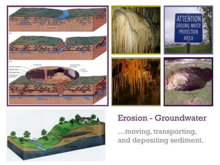
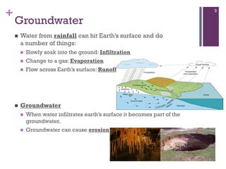
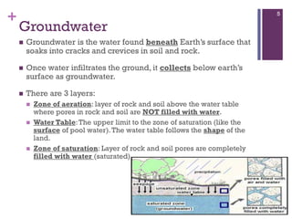
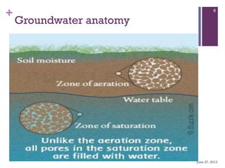
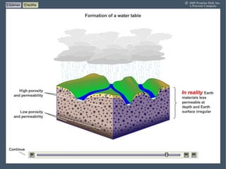
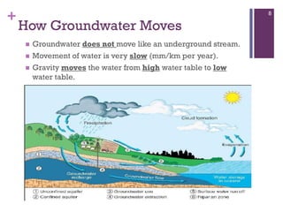
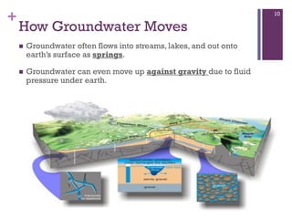
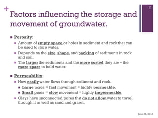
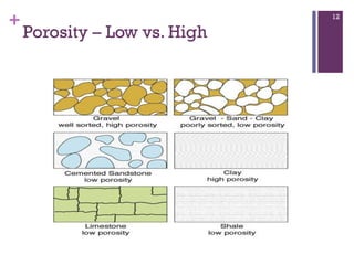
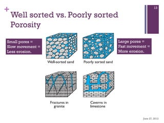
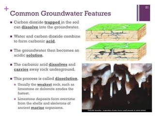
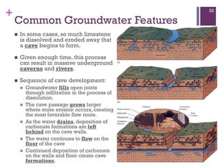
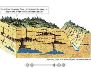
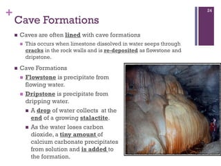
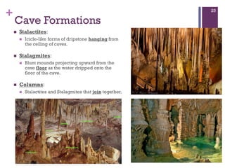
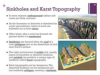
Groundwater forms when water infiltrates the earth's surface and collects underground. It is found in the saturated zone below the water table. Groundwater moves slowly through the pores and cracks in soil, sand, and rock. Over time, groundwater can cause erosion and dissolve limestone bedrock to form caves, sinkholes, and karst topography.
Flowing water has the ability to dissolve the soluble mineral substances available on its way. The processes enacted by streams are called as fluvial processes. The word “fluvius” is derived from the latin word meaning “ river”. The world fluvial is used to denote the running water as streams or rivers. Fluvial processes entail the erosion, transportation, and deposition of earth materials by running water. Fluvial processes and fluvial landforms dominate land surfaces the world over, as opposed to the limited effects of glacial, coastal, and wind processes.
Physical Geography Lecture 09 - Water Resources (Ground water and ice) 110716angelaorr
Movement and locations of water. Underground water. Soil water belt, subsurface flow. Percolation. Porosity and Permeability. Hydrologic Zones. Zone of aeration, zone of saturation, water table, effluent and influent condition. Zone of confined water, aquaclude, aquifer, artesian well. Waterless zone. Groundwater management. Groundwater management issues. Aquifer recharge, cone of depression, subsidence, groundwater contamination. The case of Venice Italy. Hydrothermal activity. Hot springs, geysers, fumaroles. Permafrost, melting permafrost. Glaciers, alpine and continental glaciers. Melting glaciers. Lakes. Destruction of the Aral Sea. Swamps and marshes. Streams.
Drainage pattern & morphometric analyses of drainage basinsUjjavalPatel16
Drainage Pattern & Morphometric analyses of drainage basins.
In geomorphology, the patterns formed by the streams, rivers, and lakes in a particular drainage basin. Also known as drainage systems or river systems.
According to the configuration of the channels, drainage systems can fall into one of several categories known as drainage patterns. Drainage patterns depend on the topography & geology of the land.
Drainage basins: The total land surface drained by a system of stream leading to the same outflow.
Drainage system: The stream, tributaries, and other bodies of water by which a region is called drained.
Drainage divide: The boundary between adjacent drainage basins.
An area of land drained by a river and its tributaries.
It is also called the Catchment area.
Any precipitation which falls into the basin is collected and drains into the main river or its tributaries by runoff, throughflow or groundwater flow.
Its boundary marked by a ridge of high land called watershed.
Drainage basins have one main stream and many tributaries.
Each tributaries of main stream forms sub-drainage basin.
Glaciers are the moving masses of ice. They are the permanent masses of ice that form over the land. These glaciers are originated from the compaction and crystallization of snow. When low temperature and sufficient snowfalls occur over a region we get the glaciers and snow fields will be having very low temperature and continuous snowfalls, glaciers are masses of ice that flow under the action of gravity. Glacier is a natural moving body of crystalline ice of great dimension. A glacier is a typical geological agent and as ice flows over the mountains and regions or land plain lands glaciers can erode, transport and deposit the materials carried away by suspension.
Geological work of the wind, deflation, wind abrasion, desert pavement,
ventifacts, desert dunes and sand sheets, sand seas or ergs, loess, coastal dunes, sand hills and
sabkhas, loess and evolution of deserts: Wind action and desert landscape
TRUE OR FALSE: The Earth’s surface has stayed the same for thousands of years
FALSE: the Earth’s surface is always changing
EXAMPLE
EROSION & DEPOSITION
EROSION
Is the process by which natural forces move weathered rock and soil from one place to another.
Sediment – material moved by erosion .
DEPOSITION
Occurs where the agents of erosion lay down sediment.
Mass Movement
Any one of several processes that move sediment downhill.
Different types of Mass Movement
Landslide
- occurs when rock and soil slide quickly down a steep slope.
Different types of Mass Movement
Mudflow
- mudflow is a rapid downhill movement of a mixture of water, rock, and soil.
Different types of Mass Movement
Slump
- a mass of rock and soil suddenly slips down a slope.
Different types of Mass Movement
Creep
- very slow downhill movement of rock and soil.
Water Erosion
Rills and Gullies
Rills
- tiny grooves in the soil.
Gully
- a large groove , or channel, in the soil that carries runoff after a rainstorm
Streams and Rivers
Stream
- a channel along which water is continually flowing down a slope.
River
- a large stream
Amount of Runoff
In an area depends on five main factors:
1st – amount of rain
2nd – vegetation
3rd – type of soil
4th – shape of the land
5th – how people use the land
Erosion by River
Through erosion, a river creates a waterfalls, flood plains, meanders, and oxbow lakes.
Waterfall
May occur where a river meets an area of rock that is very hard and erodes slowly.
Flood plain
Flat, wide area of land along a river.
Meander
A loop like bend in the course of the river
Oxbow lake
A meander that has been cut off from the river.
Deposits by River
Deposition creates landforms such as alluvial fans and deltas. It can also add soil to a river’s flood plain.
Alluvial Fans
A wide, sloping deposit of sediment formed where a stream leaves a mountain range.
Deltas
Sediment deposited where a river flows into an ocean or lake.
Groundwater Erosion
Groundwater can cause erosion through a process of chemical weathering.
Stalactite – hangs down from the roof of a cave.
Stalagmite – pointed piece of rock that sticks u p from the floor.
How Water Erode and Carries Sediment
Most sediment washes or falls into the river as a result of mass movement and runoff. Other sediment erodes from the bottom or sides of the river.
Abrasion- is the wearing away of rock by grinding action.
- occurs when particles of sediment in flowing water bumped into the steam again and again.
Erosion and Sediment Load
A river’s slope, volume of flow, and the shape of its trembled all affect how fast the river flows and how much sediment it can erode.
Slope
Is the amount the river drops toward sea level over a give distance.
Volume of Flow
A river’s flow is the volume of water that moves past a point on the river on a given time.
Streambed Shape
Affects the
2024.06.01 Introducing a competency framework for languag learning materials ...Sandy Millin
http://sandymillin.wordpress.com/iateflwebinar2024
Published classroom materials form the basis of syllabuses, drive teacher professional development, and have a potentially huge influence on learners, teachers and education systems. All teachers also create their own materials, whether a few sentences on a blackboard, a highly-structured fully-realised online course, or anything in between. Despite this, the knowledge and skills needed to create effective language learning materials are rarely part of teacher training, and are mostly learnt by trial and error.
Knowledge and skills frameworks, generally called competency frameworks, for ELT teachers, trainers and managers have existed for a few years now. However, until I created one for my MA dissertation, there wasn’t one drawing together what we need to know and do to be able to effectively produce language learning materials.
This webinar will introduce you to my framework, highlighting the key competencies I identified from my research. It will also show how anybody involved in language teaching (any language, not just English!), teacher training, managing schools or developing language learning materials can benefit from using the framework.
Synthetic Fiber Construction in lab .pptxPavel ( NSTU)
Synthetic fiber production is a fascinating and complex field that blends chemistry, engineering, and environmental science. By understanding these aspects, students can gain a comprehensive view of synthetic fiber production, its impact on society and the environment, and the potential for future innovations. Synthetic fibers play a crucial role in modern society, impacting various aspects of daily life, industry, and the environment. ynthetic fibers are integral to modern life, offering a range of benefits from cost-effectiveness and versatility to innovative applications and performance characteristics. While they pose environmental challenges, ongoing research and development aim to create more sustainable and eco-friendly alternatives. Understanding the importance of synthetic fibers helps in appreciating their role in the economy, industry, and daily life, while also emphasizing the need for sustainable practices and innovation.
Welcome to TechSoup New Member Orientation and Q&A (May 2024).pdfTechSoup
In this webinar you will learn how your organization can access TechSoup's wide variety of product discount and donation programs. From hardware to software, we'll give you a tour of the tools available to help your nonprofit with productivity, collaboration, financial management, donor tracking, security, and more.
Palestine last event orientationfvgnh .pptxRaedMohamed3
An EFL lesson about the current events in Palestine. It is intended to be for intermediate students who wish to increase their listening skills through a short lesson in power point.
We all have good and bad thoughts from time to time and situation to situation. We are bombarded daily with spiraling thoughts(both negative and positive) creating all-consuming feel , making us difficult to manage with associated suffering. Good thoughts are like our Mob Signal (Positive thought) amidst noise(negative thought) in the atmosphere. Negative thoughts like noise outweigh positive thoughts. These thoughts often create unwanted confusion, trouble, stress and frustration in our mind as well as chaos in our physical world. Negative thoughts are also known as “distorted thinking”.
This is a presentation by Dada Robert in a Your Skill Boost masterclass organised by the Excellence Foundation for South Sudan (EFSS) on Saturday, the 25th and Sunday, the 26th of May 2024.
He discussed the concept of quality improvement, emphasizing its applicability to various aspects of life, including personal, project, and program improvements. He defined quality as doing the right thing at the right time in the right way to achieve the best possible results and discussed the concept of the "gap" between what we know and what we do, and how this gap represents the areas we need to improve. He explained the scientific approach to quality improvement, which involves systematic performance analysis, testing and learning, and implementing change ideas. He also highlighted the importance of client focus and a team approach to quality improvement.
How to Make a Field invisible in Odoo 17Celine George
It is possible to hide or invisible some fields in odoo. Commonly using “invisible” attribute in the field definition to invisible the fields. This slide will show how to make a field invisible in odoo 17.
3. +
Groundwater
Water from rainfall can hit Earth’s surface and do
a number of things:
Slowly soak into the ground: Infiltration
Change to a gas: Evaporation
Flow across Earth’s surface: Runoff
3
Groundwater
When water infiltrates earth’s surface it becomes part of the
groundwater.
Groundwater can cause erosion
4. +
Factors affecting infiltration
June 27, 2013
4
The intensity and duration of rainfall
The harder and longer it rains, the less infiltration
The water content of the soil
Is the soil saturated, or can rainfall soak into it?
Slope of the land
Water will run off and not soak into a steep slope.
Vegetation
Vegetation can slow runoff and allow the surface
water to soak in.
Porosity and Permeability of rock
How easily water moves through pores (holes) in
the rock and sediment.
5. +
Groundwater
Groundwater is the water found beneath Earth’s surface that
soaks into cracks and crevices in soil and rock.
Once water infiltrates the ground, it collects below earth’s
surface as groundwater.
There are 3 layers:
Zone of aeration: layer of rock and soil above the water table
where pores in rock and soil are NOT filled with water.
Water Table:The upper limit to the zone of saturation (like the
surface of pool water).The water table follows the shape of the
land.
Zone of saturation: Layer of rock and soil pores are completely
filled with water (saturated).
5
8. +
How Groundwater Moves
Groundwater does not move like an underground stream.
Movement of water is very slow (mm/km per year).
Gravity moves the water from high water table to low
water table.
8
10. +
How Groundwater Moves
10
Groundwater often flows into streams, lakes, and out onto
earth’s surface as springs.
Groundwater can even move up against gravity due to fluid
pressure under earth.
11. +
Factors influencing the storage and
movement of groundwater.
Porosity:
Amount of empty space or holes in sediment and rock that can
be used to store water.
Depends on the size, shape, and packing of sediments in rock
and soil.
The larger the sediments and the more sorted they are – the
more space to hold water.
Permeability:
How easily water flows through sediment and rock.
Large pores = fast movement = highly permeable.
Small pores = slow movement = highly impermeable.
Clays have unconnected pores that do not allow water to travel
through it as well as sand and gravel.
June 27, 2013
11
13. +
Well sorted vs. Poorly sorted
Porosity
June 27, 2013
13
Large pores =
Fast movement =
More erosion.
Small pores =
Slow movement =
Less erosion.
14. +
Common Groundwater Features
Aquitards
Layer of soil or rock that are impermeable.
Usually layers of clay.
Groundwater cannot pass through.
Aquifers:
Layers of rock and soil that are highly permeable.
Usually sand and gravel.
Groundwater can pass through easily.
14
16. +
Common groundwater features
Wells:
To obtain water by drilling through the water table into the zone
of saturation.
The water table rises and falls throughout the year as conditions
change from dry to wet.
The drier it is, the lower the water table = water levels in wells
are lower.
The wetter it is, the higher the water table = water levels in
wells are higher.
16
17. +
Common groundwater features
17
Cone of Depression
When too many wells are dug in the same area, the water table can also go
down.
It creates a dip in the water table.
19. +
Common groundwater features
Artesian Wells:
A free flowing well where water rises on its own.
Created by pressure produced when water is trapped between
two impermeable layers.
19
21. +
Common Groundwater Features
Carbon dioxide trapped in the soil
can dissolve into the groundwater.
Water and carbon dioxide combine
to form carbonic acid.
The groundwater then becomes an
acidic solution.
The carbonic acid dissolves and
carries away rock underground.
This process is called dissolution.
Usually the weakest rock, such as
limestone or dolomite erodes the
fastest.
Limestone deposits form overtime
from the shells and skeletons of
ancient marine organisms.
21
22. +
Common Groundwater Features
In some cases, so much limestone
is dissolved and eroded away that
a cave begins to form.
Given enough time, this process
can result in massive underground
caverns and rivers.
Sequence of cave development:
Groundwater fills open joints
through infiltration in the process of
dissolution.
The cave passage grows larger
where more erosion occurs, creating
the most favorable flow route.
As the water drains, deposition of
carbonate formations are left
behind on the cave walls.
The water continues to flow on the
floor of the cave
Continued deposition of carbonate
on the walls and floor create cave
formations. June 27, 2013
22
24. +
Cave Formations
Caves are often lined with cave formations
This occurs when limestone dissolved in water seeps through
cracks in the rock walls and is re-deposited as flowstone and
dripstone.
24
Cave Formations
Flowstone is precipitate from
flowing water.
Dripstone is precipitate from
dripping water.
A drop of water collects at the
end of a growing stalactite.
As the water loses carbon
dioxide, a tiny amount of
calcium carbonate precipitates
from solution and is added to
the formation.
25. +
Cave Formations
Stalactites:
Icicle-like forms of dripstone hanging from
the ceiling of caves.
Stalagmites:
Blunt mounds projecting upward from the
cave floor as the water dripped onto the
floor of the cave.
Columns:
Stalactites and Stalagmites that join together.
25
26. +
Sinkholes and Karst Topography
In some regions, underground valleys and
caves are fairly common.
As the limestone or dolomite is dissolved by
acidic groundwater, layers of earth are
hollowed out to form caves.
Often times, after a cave has formed, the
ground above it is weakened.
Sinkholes are formed when the roof of a
cave collapses due to the dissolution of rock
near Earth’s surface.
The right environment of acidic soil, usually
layers of limestone or dolomite bedrock,
and rainfall can produce a unique type of
landform called karst topography.
Karst topography can be dangerous.The
dissolved bedrock can be weakened and
can suddenly collapse, creating a sinkhole.
26