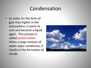
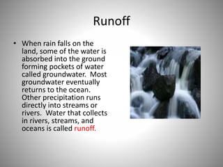
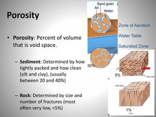
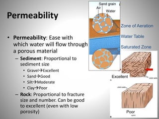
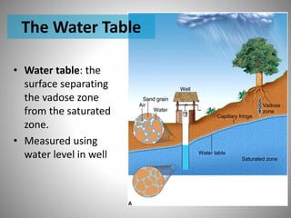
The document discusses various topics related to hydrologic cycles and groundwater including:
1) The water cycle is driven by energy from the sun and involves evaporation, transpiration, condensation, precipitation, and runoff.
2) Groundwater occurs below the ground surface in voids and fractures in rocks and soil based on porosity and permeability.
3) Aquifers are underground areas that store and transmit groundwater while aquicludes and aquitards have low permeability and transmit water slowly or not at all.
4) Different rock types like sedimentary, igneous, and metamorphic rocks can serve as aquifers depending on their porosity and permeability.
The subsurface occurrence of groundwater may be divided into zones of aeration and saturation. The vertical distribution of groundwater is explained in this module.
It includes the definition, properties, classification of groundwater with appropriate examples and figures in details. It also deals about the formation of groundwater. The properties of aquifers (all of 7) are described here in details with figures and mathematical terms.
An aquifer is an underground layer of water-bearing rock. Water-bearing rocks are permeable, meaning that they have openings that liquids and gases can pass through. Sedimentary rock such as sandstone, as well as sand and gravel, are examples of water-bearing rock.
paper about the underground water and its geotechnical problems and how to control it
This is a large and complex topic and I have to focus on some key points that you need it to finish the project of the tunneling subject that you're working on it
Groundwater province is an area or region in which geology and climate combine to produce groundwater conditions consistent enough to permit useful generalisations.
Stream flow representing the runoff phase of the hydrologic cycle is the most important basic data for hydrologic studies. Runoff is generated by rainstorms. Its occurrence and quantity are dependent on the characteristics of the rainfall event, i.e. intensity, duration and distribution. This module highlights about runoff components of the hydrological cycle.
The Chicot Aquifer and the I-49 Connector ProjectRodney Hess
This presentation from the Upper Lafayette "Focus on I-49 Connector” panel discussion held March 16th at the LITE Center, provides information about the Chicot Aquifer.
Hydrologic Cycle is also called as Water Cycle. It basically deals with transformation of water in different forms starting from gaseous stage (water vapor) to liquid state (water on earth's surface), and water inside soil as underground water.and again back to gaseous stage. The cycle has no starting or end.
The hydrological cycle is the system which describes the distribution and movement of water between the earth and its atmosphere. The model involves the continual circulation of water between the oceans, the atmosphere, vegetation and land.
AS Level Physical Geography - Hydrology and Fluvial GeomorphologyArm Punyathorn
Water is an agent of change in the atmosphere, geosphere and biosphere. In this chapter we will try to understand the passage of water as it changes states.We will also look at how the forces of river can shape land forms as well as civilization
Hydrology and Fluvial Geo morphology for CAMBRIDGE AS level Yonas Gemeda
This power point lesson describes about the hydrology and rivers work in detail with different tools, which is more important for students and candidates of Cambridge Examination at AS level.
3. Topic
• Hydrologic Cycle
• Sources Of Ground water
• Occurance of Ground water
• Terms related to Ground water
• Types of Aquifers
• Different Rocks as Aquifers
• Artificial Recharge
4.
5. Water never leaves the Earth. It is constantly being
cycled through the atmosphere, ocean, and land.
This process, known as the water cycle, is driven by
energy from the sun. The water cycle is crucial to the
existence of life on our planet.
6. Evaporation
• During part of the water
cycle, the sun heats up
liquid water and changes
it to a gas by the process
of evaporation. Water
that evaporates from
Earth’s oceans, lakes,
rivers, and moist soil rises
up into the atmosphere.
7. Transpiration
• The process of
evaporation from
plants is called
transpiration. (In
other words, it’s
like plants
sweating.)
8. Condensation
• As water (in the form of
gas) rises higher in the
atmosphere, it starts to
cool and become a liquid
again. This process is
called condensation.
When a large amount of
water vapor condenses, it
results in the formation of
clouds.
9. Precipitation
• When the water in the
clouds gets too heavy,
the water falls back to
the earth. This is called
precipitation.
10. Runoff
• When rain falls on the
land, some of the water is
absorbed into the ground
forming pockets of water
called groundwater. Most
groundwater eventually
returns to the ocean.
Other precipitation runs
directly into streams or
rivers. Water that collects
in rivers, streams, and
oceans is called runoff.
11. Meteorological factors affecting
surface (over soil) runoff
- Type of precipitation
- Rainfall intensity
- Rainfall amount
- Rainfall duration
- Distribution of rainfall over the drainage basin
- Direction of storm movement
- Precipitation that occurred earlier and resulting soil
moisture
- Meteorological conditions that affect
evapotranspiration
12. Physical characteristics affecting
surface runoff
- Land use
- Vegetation
- Soil type
- Drainage area
- Basin shape
- Elevation
- Topography, especially the slope
of the land
- Drainage network patterns
- Ponds, lakes, reservoirs, sinks, etc.
in the basin, which prevent or
delay runoff from continuing
downstream
13. Groundwater begins as INFILTRATION
Precipitation falls and
infiltrates into the
subsurface soil and
rock
•Can remain in shallow soil layer
•Might seep into a stream bank
•May infiltrate deeper, recharging an aquifer
•May travel long distances
•May stay in storage as ground water
14. Factors affecting infiltration
• Precipitation (greatest factor)
• Magnitude, intensity, duration
• Characteristics (rain, snow)
• Soil Characteristics
– Clay absorbs less water at a slower rate than sand
• Soil Saturation
– Higher saturation leads to more runoff instead
• Land Cover
• Slope of the Land
– Hills enhance runoff velocity
• Evapotranspiration
– Plants use soil moisture to grow and transpire
15. Source of Ground Water
• springs
• Infiltration Galleries
• Well
• Karez
16. • Springs :
– A spring is a flow of
ground water at the
ground surface.
– A pervious layer,
sandwiched
between two
impervious layers,
give rice to a
natural spring.
17. • Infiltration Galleries :
– An infiltration gallery is a
horizontal conduit
having permeable
boundaries so that
ground water can
infiltrate into the same.
It is generally provided in
highly permeable
aquifers with high water
table so that adequate
head is available for
gravity flow of ground
water into the gallery.
18. Occurance of Ground Water
• The rainfall that percolates below the ground
surface, passes through the voids of the rocks,
and joints the water table. This voids are
generally interconnected, permitting the
movement of the ground water.
• Occurance of ground water mainly depends
upon two geological features :
– The porosity of the rocks
– The permeability of the rocks
19. Porosity
• Porosity: Percent of volume
that is void space.
– Sediment: Determined by how
tightly packed and how clean
(silt and clay), (usually
between 20 and 40%)
Zone of Aeration
Water Table
Saturated Zone
5%
30%
– Rock: Determined by size and
number of fractures (most
often very low, <5%) 1%
20. Permeability
• Permeability: Ease with
which water will flow through
a porous material
– Sediment: Proportional to
sediment size
• GravelExcellent
• SandGood
• SiltModerate
• ClayPoor
– Rock: Proportional to fracture
size and number. Can be good
to excellent (even with low
porosity)
Zone of Aeration
Water Table
Saturated Zone
Excellent
Poor
21. Terms Related to Ground Water
• Aquifer
• Aquiclude
• Aquitard
• Aquifuge
• Porosity
• Specific yield
• Specific retention
• Storage co-efficient
• Co-efficient of permeability
• Co-efficient of transmissibility
• Water table
22. • Aquifer:
Saturated
sediment or
porous rock that is
sufficiently
permeable to
supply useable
amounts of water
23. • Aquiclude :
– An aquiclude may be define as a geological
formation of relatively in permeable material
which permits storage of water but it is not
capable of transmitting water in sufficient
quantity.
– For example,
• Clay
24. • Aquitard :
– A geological formation that as poor permeability,
but through which seepage is possible, and hence,
it does not yield water freely to wells.
– It may be transmit vertically appreciable
quantities of water to or from adjacent aquifers.
– For example,
• Sandy clay
25. The Water Table
• Water table: the
surface separating
the vadose zone
from the saturated
zone.
• Measured using
water level in well
27. Unconfined and Confined Aquifer
• Unconfined Aquifer: open to atmosphere
e.g., overlain by permeable rocks and soils
• Confined aquifer: sandwiched between
aquitards
–Artesian System: Water rises above the
level in aquifer because of hydrostatic
pressure
28. Different Rocks as Aquifers
• Igneous rocks :
– It are either intrusive or extrusive in nature.
– The intrusive igneous rocks like Granites,
Syenites. etc.
29. • Sedimentary rocks :
– Among sedimentary rocks, the most common ones
are shales, sandstones and limestone shales are
impermeable rocks, though considerably porous.
– Clay may have 50-60% porosity.
– For example,
• Gravels
• Sand beds
• Sandstones
• limestones
30. • Metamorphic rocks :
–Non-foliated metamorphic rocks like
marble and quartzite are generally
impermeable.
–These rocks, thus behave as
aquicludes.
31. Artificial Recharge
• Due to rapid industrialisation,
population increase, intensive
agriculture, etc. the use of water has
been considerably increased.
• For these purpose water is pumped
from the ground water sources.
32. Methods of Recharging
• Recharging of open wells
• Infiltration bore well
• Hidden dam
• Infiltration tank
• Infiltration tank in river bed
• Infiltration borewell or tube well in river bed
• Recharging of lost rivers
• Check dam