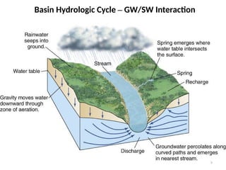
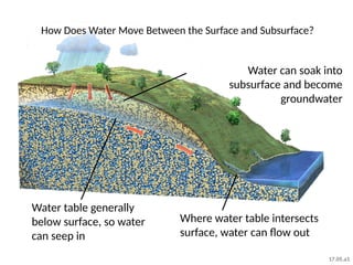
How Does WaterMove Between the Surface and Subsurface?
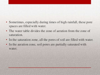
Water table generally
below surface, so water
can seep in
Water can soak into
subsurface and become
groundwater
Where water table intersects
surface, water can flow out
17.05.a1
20.
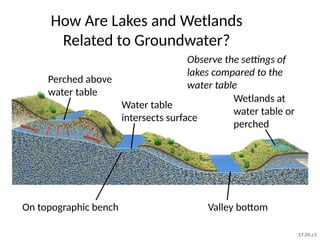
How Are Lakesand Wetlands
Related to Groundwater?
Observe the settings of
lakes compared to the
water table
Water table
intersects surface
Perched above
water table
Wetlands at
water table or
perched
On topographic bench Valley bottom
17.05.c1
21.
How Do StreamsInteract with Water
Table?
Stream higher than
water table: loses
water
Stream lower than water
table: gains water
Mound of groundwater below stream
from water flowing into subsurface
17.05.d
22.
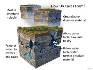
How Do CavesForm?
Groundwater
dissolves material
Most in
limestone
(soluble)
Features
widen to
cavities
and caves
Above water
table, cave may
be dry
Below water
table water
further dissolves
material
17.06.a1
23.
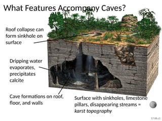
What Features AccompanyCaves?
Dripping water
evaporates,
precipitates
calcite
Roof collapse can
form sinkhole on
surface
Cave formations on roof,
floor, and walls
Surface with sinkholes, limestone
pillars, disappearing streams =
karst topography
17.06.c1
24.
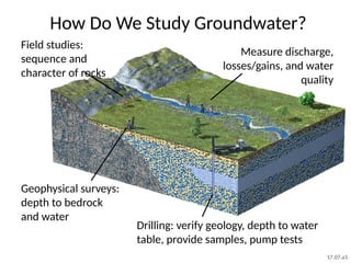
How Do WeStudy Groundwater?
Geophysical surveys:
depth to bedrock
and water
Field studies:
sequence and
character of rocks
Drilling: verify geology, depth to water
table, provide samples, pump tests
Measure discharge,
losses/gains, and water
quality
17.07.a1
25.
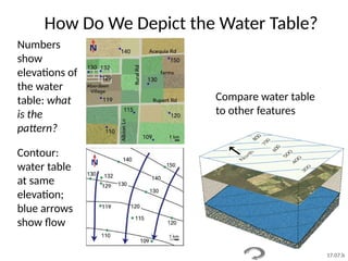
How Do WeDepict the Water Table?
Contour:
water table
at same
elevation;
blue arrows
show flow
Numbers
show
elevations of
the water
table: what
is the
pattern?
Compare water table
to other features
17.07.b
26.
Effects of OverpumpingGroundwater
After pumping:
cone of depression
Before
overpumping
17.08.a
27.
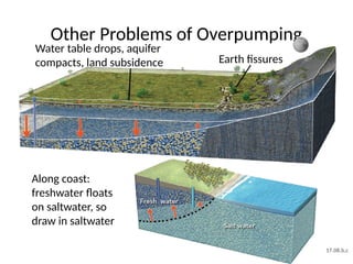
Other Problems ofOverpumping
Along coast:
freshwater floats
on saltwater, so
draw in saltwater
Water table drops, aquifer
compacts, land subsidence Earth fissures
17.08.b,c
28.
How Can Water
BecomeContaminated?
Identify possible sources of
surface water and
groundwater contamination
Landfill
Mining and naturally
mineralized rock
Septic
tank
Farm
Leaking tank
in gas station Truck
fuel
spill
Dry
cleaner
Brought
by river
Factory wells,
spills, emissions
Fuel
storage
tanks
Brought from outside
area by groundwater
Households
17.09.a1
29.
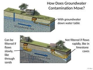
How Does Groundwater
ContaminationMove?
Can be
filtered if
flows
slowly,
like
through
sands
With groundwater
down water table
Not filtered if flows
rapidly, like in
limestone
caves
17.10.a
30.
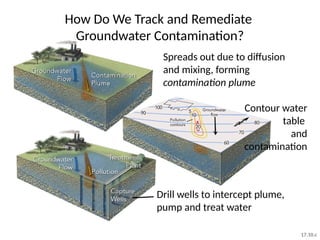
How Do WeTrack and Remediate
Groundwater Contamination?
Contour water
table
and
contamination
Drill wells to intercept plume,
pump and treat water
Spreads out due to diffusion
and mixing, forming
contamination plume
17.10.c
32.
32
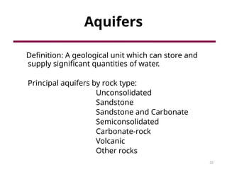
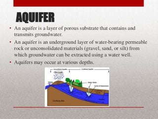
Aquifers
Definition: A geologicalunit which can store and
supply significant quantities of water.
Principal aquifers by rock type:
Unconsolidated
Sandstone
Sandstone and Carbonate
Semiconsolidated
Carbonate-rock
Volcanic
Other rocks
33.
33
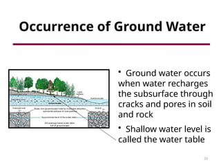
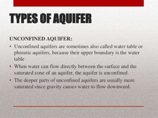
Occurrence of GroundWater
• Ground water occurs
when water recharges
the subsurface through
cracks and pores in soil
and rock
• Shallow water level is
called the water table
34.
34
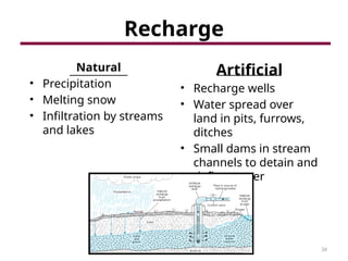
Recharge
Natural
• Precipitation
• Meltingsnow
• Infiltration by streams
and lakes
Artificial
• Recharge wells
• Water spread over
land in pits, furrows,
ditches
• Small dams in stream
channels to detain and
deflect water
37
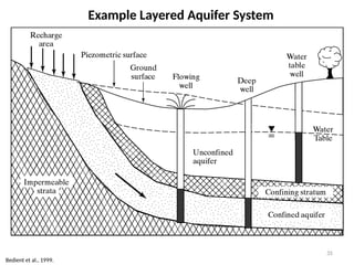
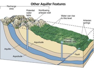
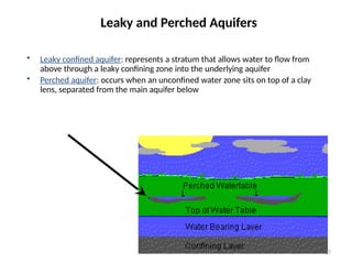
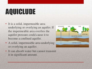
• Leaky confinedaquifer: represents a stratum that allows water to flow from
above through a leaky confining zone into the underlying aquifer
• Perched aquifer: occurs when an unconfined water zone sits on top of a clay
lens, separated from the main aquifer below
Leaky and Perched Aquifers
Editor's Notes
#19 EXPLANATION
Precipitation, snowmelt, and surface water can soak into subsurface and become groundwater
Water table is generally below surface, providing unsaturated zone into which water can seep
Where water table intersects surface, water can flow out into spring, lake, or river
#20 INSTRUCTIONS TO STUDENTS
Observe how the water table relates to these lakes and wetlands
(After explanation) How do you think you could determine which of these settings a lake would be in?
Possible answers
determine elevation of water table by drilling
see whether a lake was losing or gaining water by modeling inflow, outflow, and evaporation
compare the chemistry of the lake water with runoff and with groundwater
EXPLANATION
Perched above water table with outflow to subsurface
Where water table intersects the surface (normal setting for lakes)
Lake on bench (flat area) in topography
Lake on bottom of valley, where water table is flat
Wetlands can be at water table or perched above an impermeable zone
#21 INSTRUCTIONS TO STUDENTS
Observe how each river relates to the water table and whether water flows from the river to groundwater or from groundwater to the river
How do you think you could determine which situation was occurring?
Possible answers
determine elevation of water table by drilling
see whether a lake was losing or gaining water by modeling inflow, outflow, and evaporation
compare the chemistry of the lake water with runoff and with groundwater
EXPLANATION
River lower than water table can gain water from inflow of groundwater
River higher than water table can lose water to groundwater
Mound of groundwater can form below river due to outflow of river water into groundwater
#22 INSTRUCTIONS TO STUDENTS
(after explanation) How might we determine whether a cave is present at depth but not expressed at the surface?
Possible answers
see if the rock limestone at the surface
drilling
geophysical surveys, such as ground-penetrating radar, if shallow
EXPLANATION
Most caves form in soluble rocks, such as limestone
Groundwater in fractures and bedding planes dissolves material
Dissolution widens bedding planes and fractures until they become cavities and caves
Part of cave above water table may be mostly dry
Cave below water table will contain water that further dissolves material, enlarging cave
A sinkhole develops over the collapsed part of the cave on the right side
A cave may not have any expression at the surface, as on the left side
#23 MEDIA
1706a2_Plateau_Sinkholes.kmz
1706a2_Florida_Sinkhole_Lakes.kmz
1706b1_Karst_WV.kmz
EXPLANATION
Roof of a cave can collapse, forming sinkhole on surface (especially a cave above water table)
Water dripping off roof evaporates, precipitating calcite and other minerals
Minerals build up cave formations from roof, floor, and walls
Surface with sinkholes, limestone pillars, disappearing streams = karst topography
If the cave is filled with water, it is less likely to collapse because the water is helping hold up the roof
If the cave is filled with water, typical cave formations are not forming because there are no drips or evaporation
Some caves may have been partially filled with water or were once dry, and have since been refilled when the water table rose
Water in caves can flow or be stationary
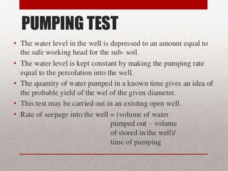
#24 EXPLANATION
Explain a pumping test
Field studies
Types of rock and sediment
Estimate of overall permeability
Abundance and orientation of fractures
Orientation of layers
Presence or absence of cavities
Characteristics of the material, such as clast size and degree of sorting
Geophysical surveys
Gravity surveys to determine depth to bedrock
Seismic surveys to determine geometry of layers, units, and faults
Electrical surveys to determine location of water table and geometry of units
Drilling
Describe the sequence of materials versus depth
Characteristics of the materials (clast size)
Abundance and dip of fractures
Lowering special video cameras down the drill hole
Geophysical surveys done within a drill hole, such as how much radioactivity each layer gives off
#25 MEDIA
1707b3_groundwater_map.mov
Relates the sloping groundwater surface in the aquifer to the land surface and a groundwater contour map
INSTRUCTIONS TO STUDENTS
Examine the map on the upper left, which shows elevations of the water table
What is the pattern of elevations, and which way do you think groundwater would flow?
EXPLANATION
Contours mark where water table is at same elevation; blue arrows show flow
We visualize system to compare water table to other features, such as farms with wells that pump high volumes (this is a different area)
EXERCISE
Have students contour a simple map showing only the elevation of points, and then draw arrows perpendicular to contours and in a downslope direction
#26 EXPLANATION
Before over-pumping, water table is fairly flat and water flows to left, past small well
Larger well causes cone of depression in water table, changing direction of flow
A cone of depression forms because water cannot flow fast enough to replenish the amount of water that is withdrawn from the well
In many cones, the water table becomes steeper near the well because water is withdrawn too fast
#27 MEDIA
1708b4_Picacho_Peak_Fissures.kmz
Google Earth file of Picacho Peak area, Arizona, shows earth fissures crossing desert, canal, and I-10
Central Arizona Canal (up against the mountain) was built close to bedrock to try to avoid the fissures
EXPLANATION
As water table drops, the aquifer compacts, causing subsidence of land surface
Fissures form along boundaries between more and less subsidence
Along coast, freshwater floats on saltwater, so overpumping can draw saltwater into bottom of coastal wells
Areas can drop meters to tens of meters in elevation
Detect subsidence with repeated surveying with conventional surveying equipment, GPS, and other satellite measurements
Once compaction occurs, the pore space cannot be regained if the water table is allowed to rise (lost permeability, porosity, and storage capacity of the reservoir)
Fissures related to subsidence can be tens of meters wide, kilometers long, and tens to over a hundred meters deep
Fissures provide easy access for contaminant into the groundwater without being filtered
#28 INSTRUCTIONS TO STUDENTS
Observe this scene and identify all possible sources of water contamination
#29 EXPLANATION
Contamination largely moves with groundwater down the slope of the water table
Can be naturally filtered out with enough time: flows slowly and in contact with material like sand
Not filtered if flows rapidly through a rock, such as a limestone with open cavities
Importance for considering the direction of groundwater flow when sighting the relative positions of a water well and contamination sources, such as a septic tank
In general, put the well uphill of a septic tank, but be aware of what is farther up the hill
#30 EXPLANATION
Contamination spreads out due to diffusion and mixing, forming a contamination plume
Contour water table and concentration of contaminant to track plume
Drill wells to intercept plume, pump out and treat water
Dispose of contaminated water or treat it with activated charcoal or certain geologic materials