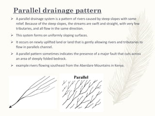
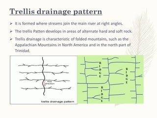
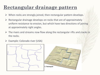
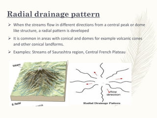
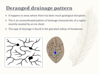
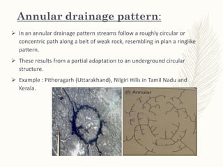
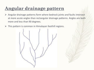
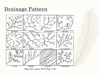
Drainage Pattern
Kamrul Islam Karim
Drainage Pattern
– drainage systems, also known as river systems.
– the patterns formed by the streams, rivers, and lakes in a
particular drainage basin.
– A drainage basin is the topographic region from which a
stream receives runoff, through flow, and groundwater flow.
– Drainage patterns:
– According to the configuration of the channels, drainage
systems can fall into one of several categories known as
drainage patterns.
– Drainage patterns depend the topography and geology of the
land.
Types of Drainage Pattern
1. Dendritic drainage pattern
2. Parallel drainage pattern
3. Trellis drainage pattern
4. Rectangular drainage pattern
5. Radial drainage pattern
6. Centripetal drainage pattern
7. Deranged drainage pattern
8. Annular drainage pattern:
9. Angular drainage pattern
10. Discordant drainage patterns
Dendritic drainage pattern
 In a dendritic system, there are many contributing streams (analogous to the
twigs of a tree), which are then joined together into the tributaries of the main
river (the branches and the trunk of the tree, respectively).
 They develop where the river channel follows the slope of the terrain.
 Dendritic systems form in V-shaped valleys; as a result, the rock types must be
impervious and non-porous.
Examples: Indus, Godavari, Mahanadi, Cauvery, Krishna.
Parallel drainage pattern
 A parallel drainage system is a pattern of rivers caused by steep slopes with some
relief. Because of the steep slopes, the streams are swift and straight, with very few
tributaries, and all flow in the same direction.
 This system forms on uniformly sloping surfaces.
 It occurs on newly uplifted land or land that is gently allowing rivers and tributaries to
flow in parallels channel.
 A parallel pattern sometimes indicates the presence of a major fault that cuts across
an area of steeply folded bedrock.
 example:rivers flowing southeast from the Aberdare Mountains in Kenya.
Trellis drainage pattern
 It is formed where streams join the main river at right angles.
 The trellis Patten develops in areas of alternate hard and soft rock.
 Trellis drainage is characteristic of folded mountains, such as the
Appalachian Mountains in North America and in the north part of
Trinidad.
Rectangular drainage pattern
 When rocks are strongly joined, then rectangular pattern develops.
 Rectangular drainage develops on rocks that are of approximately
uniform resistance to erosion, but which have two directions of joining
at approximately right angles.
 The rivers and streams now flow along the rectangular rifts and cracks in
the rocks.
 Example: Colorado river (USA)
Radial drainage pattern
 When the streams flow in different directions from a central peak or dome
like structure, a radial pattern is developed
 It is common in areas with conical and domes for example volcanic cones
and other conical landforms.
 Examples: Streams of Saurashtra region, Central French Plateau
Centripetal drainage pattern
 Is found in area where rivers drain towards a central inland lake , swamp or
deoression.
 It is in essence an inland drainage system e.g. as in the case of the dead sea.
 In a low laying basin the streams converge from all side .
 Examples: streams of Ladakh, Tibet, and the Baghmati and its tributaries in
Nepal.
Deranged drainage pattern
 It happens in areas where there has been much geological disruption.
 This is an uncoordinated pattern of drainage characteristic of a region
recently vacated by an ice-sheet.
 This type of drainage is found in the glaciated valleys of Karakoram.
Annular drainage pattern:
 In an annular drainage pattern streams follow a roughly circular or
concentric path along a belt of weak rock, resembling in plan a ringlike
pattern.
 These results from a partial adaptation to an underground circular
structure.
 Example : Pithoragarh (Uttarakhand), Nilgiri Hills in Tamil Nadu and
Kerala.
Angular drainage pattern
 Angular drainage patterns form where bedrock joints and faults intersect
at more acute angles than rectangular drainage patterns. Angles are both
more and less than 90 degrees.
 This pattern is common in Himalayan foothill regions.
Drainage Pattern
Thank you

Types Drainage pattern presentation

  • 1.
  • 2.
    Drainage Pattern – drainagesystems, also known as river systems. – the patterns formed by the streams, rivers, and lakes in a particular drainage basin. – A drainage basin is the topographic region from which a stream receives runoff, through flow, and groundwater flow. – Drainage patterns: – According to the configuration of the channels, drainage systems can fall into one of several categories known as drainage patterns. – Drainage patterns depend the topography and geology of the land.
  • 3.
    Types of DrainagePattern 1. Dendritic drainage pattern 2. Parallel drainage pattern 3. Trellis drainage pattern 4. Rectangular drainage pattern 5. Radial drainage pattern 6. Centripetal drainage pattern 7. Deranged drainage pattern 8. Annular drainage pattern: 9. Angular drainage pattern 10. Discordant drainage patterns
  • 4.
    Dendritic drainage pattern In a dendritic system, there are many contributing streams (analogous to the twigs of a tree), which are then joined together into the tributaries of the main river (the branches and the trunk of the tree, respectively).  They develop where the river channel follows the slope of the terrain.  Dendritic systems form in V-shaped valleys; as a result, the rock types must be impervious and non-porous. Examples: Indus, Godavari, Mahanadi, Cauvery, Krishna.
  • 5.
    Parallel drainage pattern A parallel drainage system is a pattern of rivers caused by steep slopes with some relief. Because of the steep slopes, the streams are swift and straight, with very few tributaries, and all flow in the same direction.  This system forms on uniformly sloping surfaces.  It occurs on newly uplifted land or land that is gently allowing rivers and tributaries to flow in parallels channel.  A parallel pattern sometimes indicates the presence of a major fault that cuts across an area of steeply folded bedrock.  example:rivers flowing southeast from the Aberdare Mountains in Kenya.
  • 6.
    Trellis drainage pattern It is formed where streams join the main river at right angles.  The trellis Patten develops in areas of alternate hard and soft rock.  Trellis drainage is characteristic of folded mountains, such as the Appalachian Mountains in North America and in the north part of Trinidad.
  • 7.
    Rectangular drainage pattern When rocks are strongly joined, then rectangular pattern develops.  Rectangular drainage develops on rocks that are of approximately uniform resistance to erosion, but which have two directions of joining at approximately right angles.  The rivers and streams now flow along the rectangular rifts and cracks in the rocks.  Example: Colorado river (USA)
  • 8.
    Radial drainage pattern When the streams flow in different directions from a central peak or dome like structure, a radial pattern is developed  It is common in areas with conical and domes for example volcanic cones and other conical landforms.  Examples: Streams of Saurashtra region, Central French Plateau
  • 9.
    Centripetal drainage pattern Is found in area where rivers drain towards a central inland lake , swamp or deoression.  It is in essence an inland drainage system e.g. as in the case of the dead sea.  In a low laying basin the streams converge from all side .  Examples: streams of Ladakh, Tibet, and the Baghmati and its tributaries in Nepal.
  • 10.
    Deranged drainage pattern It happens in areas where there has been much geological disruption.  This is an uncoordinated pattern of drainage characteristic of a region recently vacated by an ice-sheet.  This type of drainage is found in the glaciated valleys of Karakoram.
  • 11.
    Annular drainage pattern: In an annular drainage pattern streams follow a roughly circular or concentric path along a belt of weak rock, resembling in plan a ringlike pattern.  These results from a partial adaptation to an underground circular structure.  Example : Pithoragarh (Uttarakhand), Nilgiri Hills in Tamil Nadu and Kerala.
  • 12.
    Angular drainage pattern Angular drainage patterns form where bedrock joints and faults intersect at more acute angles than rectangular drainage patterns. Angles are both more and less than 90 degrees.  This pattern is common in Himalayan foothill regions.
  • 13.
  • 14.