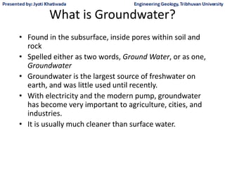
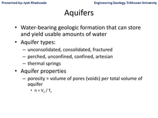
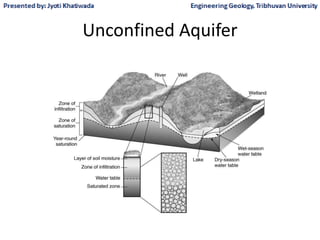
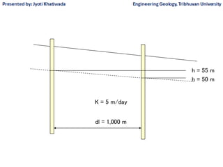
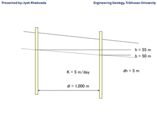
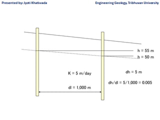
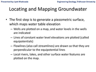
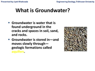
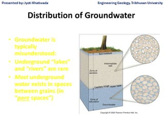
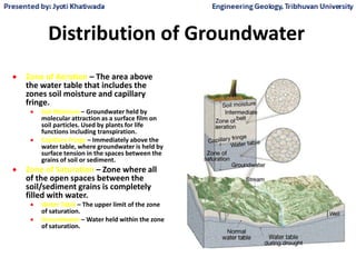
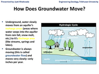
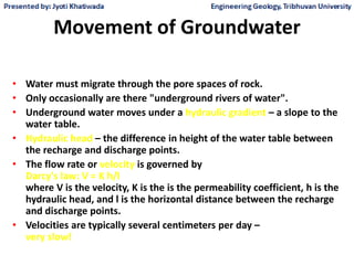
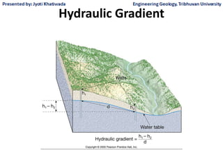
SlideShare a Scribd company logo
1 of 75
Hydrogeology
• Collected by Jyoti Anischit
Groundwater Hydrology
• What is Groundwater?
• What is Groundwater Hydrology?
• The Geology of Groundwater
• Groundwater Recharge
• Aquifers
• Groundwater Movement
• Age of Groundwater
• Locating and Mapping Groundwater
• Drilling a Groundwater Well
contd
What is Groundwater?
• Found in the subsurface, inside pores within soil and
rock
• Spelled either as two words, Ground Water, or as one,
Groundwater
• Groundwater is the largest source of freshwater on
earth, and was little used until recently.
• With electricity and the modern pump, groundwater
has become very important to agriculture, cities, and
industries.
• It is usually much cleaner than surface water.
What is Groundwater Hydrology?
• It is the study of the characteristics, movement,
and occurrence of water found below the surface.
• Groundwater and aquifers are like surface water
and watersheds
– An aquifer is a geologic unit that transmits water.
– Piezometric surfaces are used to map water levels,
similar to topographic lines on maps.
– Each aquifer has its own piezometric surface.
– The water level elevation in wells are used to create the
piezometric surface.
The Geology of Groundwater
• Sedimentary Rocks
– sandstone, shale, limestone, conglomerate
• Glaciated Terrain
– large valleys and basins were carved out
– sediments (sands, clays) were left behind
• Alluvial Valleys and Fans
– along rivers and streams
• Tectonic Formations
– solid rock is fractured by pressures due to earth’s
movement
Wikipedia
Groundwater Recharge
• Water that replenishes aquifers
• Usually from surface water or precipitation that
infiltrates, and then percolates through the vadose zone
• Recharge happens when percolating water finally
reaches the water table, which is the top of the
saturated zone.
• Above the water table is the unsaturated zone where
water is held by capillary forces
• The root zone may capture some water that infiltrates
and lift it back to the atmosphere.
Figure 4.6 Lakes and wetland complexes often exist in areas with shallow
groundwater elevations that intercept the land surface..
Groundwater Recharge
Fetter, Applied Hydrology
Infiltration
Percolation
Saturated zone
Evapotranspiration
Overland flow
Aquifers
• Water-bearing geologic formation that can store
and yield usable amounts of water
• Aquifer types:
– unconsolidated, consolidated, fractured
– perched, unconfined, confined, artesian
– thermal springs
• Aquifer properties
– porosity = volume of pores (voids) per total volume of
aquifer
• n = Vv / Tt
Unconfined Aquifer
Figure 4.10 The Ogallala Aquifer provides water to irrigators, cities, and
other groundwater users in parts of South Dakota, Nebraska, Wyoming,
Colorado, Kansas, Oklahoma, Texas, and New Mexico.
Land surface elevation
in meters
Figure 4.7 Two conditions are necessary to create an artesian groundwater system: a
confined aquifer and sufficient pressure in the aquifer to force water in a well or other opening
to rise above the static water level of the aquifer.
Confined Aquifer
Aquifer Porosity
Example Porosity Calculation
• Take a 1000-mL beaker (1 liter)
• Fill it with sand to the top
• Measure how much water it takes to fill the beaker
to the top (say 300 mL)
• The porosity = (300 mL) / (1000 mL) = 30%
Groundwater Movement
• Water moves because of two factors
– The force pushing through the subsurface
– The permeability of the geologic media
• Darcy’s Law says that the flux of water (flow per
unit area) is calculated using these two factors:
– q = K i
– q = flux of water, ft / s
– K = hydraulic conductivity, ft / s
– i = hydraulic gradient, ft / ft
Note they both
have the same
units
• The hydraulic conductivity, K, is a measure of the
permeability of the aquifer
– gravels have large hydraulic conductivities
– clays and solid rock have small values
• The hydraulic gradient is a measure of the force acting on
the water
– it is like the slope of the land surface, water flows faster where it
is steep
– i = dh / dl = slope of the water surface
– h is the hydraulic head, or water level in a well
– dh is the change in water level between two wells
– dl is the distance between the wells
– determines the direction of flow.
Direction of Flow?
Soil surface
Water table
dh
dl
dl = 1,000 m
h = 50 m
h = 55 m
K = 5 m/day
dl = 1,000 m
h = 50 m
h = 55 m
K = 5 m/day dh = 5 m
dl = 1,000 m
h = 50 m
h = 55 m
K = 5 m/day dh = 5 m
dh/dl = 5/1,000 = 0.005
dl = 1,000 m
h = 50 m
h = 55 m
K = 5 m/day dh = 5 m
dh/dl = 5/1,000 = 0.005
q = K i = 5 x 0.005
q = 0.025 m/day
Karst Aquifers
Wikipedia
Underground Rivers?
Only in Karst aquifers!!
Wikipedia
Specific Yield
• Volume of water that can be removed per unit
volume of aquifer
– less than the porosity - hard to get the last drop!
Specific Yield Calculation
• Take a 1000-mL beaker (1 liter)
• Fill it with sand to the top
• Measure how much water it takes to fill the beaker
to the top (say 300 mL)
• The porosity = (300 mL) / (1000 mL) = 30%
• We pour the water out and 250 mL is collected
• What is the specific yield?
• (250 mL) / (1000 mL) = 25%
– Can’t get the last drop!
Age of Groundwater
• Time it takes for water to move through the
subsurface
• Maybe 1 to 25 years in aquifers near Athens
• Up to 30,000 years for water down on the
coast
Locating and Mapping Groundwater
• The first step is to generate a piezometric surface,
which maps water table elevation
– Wells are plotted on a map, and water levels in the wells
are indicated
– Lines of constant water level elevations are plotted (called
equipotentials)
– Flowlines (also call streamlines) are drawn so that they are
perpendicular to the equipotential lines
– Local rivers, lakes, and other surface water features are
plotted on the map.
Figure 3.45 Water levels (in feet above sea level) in monitoring wells and
contours of total potential (piezometric surface or water table surface) at a
contaminated site (Fetter, 1988).
Figure 3.45 Water levels (in feet above sea level) in monitoring wells and
contours of total potential (piezometric surface or water table surface) at a
contaminated site (Fetter, 1988).
Drilling a Groundwater Well
• Various methods are available for drilling a well
• A simple method is the auger method, which uses a
screw-like bit. This works in soft materials
• For solid rock, a simple technique is the hammer or
percussion method which pounds a hole in the rock
• Rotary methods uses a harden steel bit tipped with
diamonds to cut through the rock. Either water, air or
mud can be used to lubricate and to lift the cuttings.
Well Components
• A well pad is placed on the surface to hold up the
well.
• A blank casing is used from the surface down to the
aquifer. Clay or concrete fills the space outside the
casing.
• A screened casing is used in the aquifer. Sand or
gravel fills the space outside the casing
• A submerged turbine pump lifts the water to the
surface. The motor that drives the pump is either on
the surface or also submerged.
Cone of
depression in
potentiometric
surface near
Albany GA
Stream Depletion Factors
• Used to assess the effects of well pumping on
stream flow
• Depend on
– the distance to the stream (less effect with greater
distance)
– properties of the aquifer
Part II
• Jyoti Anischit
The Hydrologic Cycle
Where is the Water ?
Figure 16.2
Groundwater is a Resource
• The amount of groundwater is vast but not
unlimited.
• About 0.6% of the world's water found
underground.
• It provides:
• 50% of the world's drinking water
• 40% of the water used for irrigation
• 25% of industry's needs
Nevertheless, in many places overuse and
misuse has resulted in:
streamflow depletion
land subsidence
saltwater intrusion
increased pumping costs from ever
deeper supplies
contamination
What is Groundwater?
 Groundwater is water that is
found underground in the
cracks and spaces in soil, sand,
and rocks.
 Groundwater is stored in—and
moves slowly through—
geologic formations called
aquifers.
Distribution of Groundwater
• Groundwater is
typically
misunderstood:
• Underground “lakes”
and “rivers” are rare
• Most underground
water exists in spaces
between grains (in
“pore spaces”)
Distribution of Groundwater
 Zone of Aeration – The area above
the water table that includes the
zones soil moisture and capillary
fringe.
 Soil Moisture – Groundwater held by
molecular attraction as a surface film on
soil particles. Used by plants for life
functions including transpiration.
 Capillary Fringe – Immediately above the
water table, where groundwater is held by
surface tension in the spaces between the
grains of soil or sediment.
 Zone of Saturation – Zone where all
of the open spaces between the
soil/sediment grains is completely
filled with water.
 Water Table – The upper limit of the zone
of saturation.
 Groundwater – Water held within the zone
of saturation.
How Does Groundwater Move?
 Underground, water slowly
moves from an aquifer’s
recharge areas (areas where
water seeps into the aquifer
from rain fall, snow melt,
etc.) to it’s discharge area
(like streams, springs and
lakes).
 Groundwater is always
moving (this is called
groundwater flow) and
moves very slowly--only
inches per year.
groundwater flow discharge area
evaporation
recharge area
precipitation
condensation
runoff
transpiration
aquifer
water table
infiltration
Hydrologic Cycle
The water table is rarely level; it is a subdued
replica of the surface topography. This reflects:
• Variations in rainfall (seasonal).
• The slow rate at which water moves through
the subsurface.
• The effects of gravity.
• Where a stream, lake or swamp is found, the
water table coincides with the surface of the
body of water.
Gaining Streams – Gain
water from the inflow of
groundwater through the
streambed
(the elevation of the water
table must be higher that
the elevation of the
surface of the stream).
Losing Streams – Streams
that lose water to the
groundwater system by
outflow through the
streambed
(the elevation of the water
table is lower than the
elevation of the surface of
the stream).
Figure 17.4
Factors Influencing the Storage and
Movement of Groundwater
• Rock and sediment contain voids called pore
spaces.
• The porosity is the percentage of the total
volume of rock that consists of pore spaces.
The quantity of water that can be stored
depends on the porosity.
The Solution
• You started with 5 ml. of Sand; this includes both the
sand and the pore space, in other words this is the
TOTAL VOLUME
• You poured in 5 ml of water, 4 ml remained above the
sand, 1 ml went into the sand. Where did it go? Into
the pores. The PORE SPACE VOLUME = 1 ml.
• 1ml/5ml x 100% = 20% Porosity
Different Rock Types Have Different
Porosities
• Sediment might have porosities from 10 to 50%.
• The porosity of most igneous and metamorphic rocks
is less than 1%.
• Porosity in sediments tends to be:
Higher if sediment is well sorted
Lower if sediment is well packed
Lower if sediment is well cemented
Fractures can increase the porosity in igneous,
metamorphic rocks, and certain sedimentary rocks
(especially limestones).
The quantity of groundwater that can be stored
depends on the porosity of the material.
The Permeability of Rock is It’s Ability
to Transmit Water
• Depends on porosity and
interconnectedness.
• Molecular attraction or surface tension
inhibits flow particularly in small pore spaces
(shales).
• Aquifers are rocks with high permeability
(easily transmit water).
• Aquitards are impermeable (barrier to water
flow).
If pore spaces are too small, surface tension
keeps water from moving
Aquitards Hinder or
Prevent Groundwater
Movement
Aquifer Permeability
http://serc.carleton.edu/NAGTWorkshops/visualization/collections/groundwater.html
Aquifer Speed Animation
Movement of Groundwater
• Water must migrate through the pore spaces of rock.
• Only occasionally are there "underground rivers of water".
• Underground water moves under a hydraulic gradient – a slope to the
water table.
• Hydraulic head – the difference in height of the water table between
the recharge and discharge points.
• The flow rate or velocity is governed by
Darcy's law: V = K h/l
where V is the velocity, K is the is the permeability coefficient, h is the
hydraulic head, and l is the horizontal distance between the recharge
and discharge points.
• Velocities are typically several centimeters per day –
very slow!
Hydraulic Gradient
Figure 17.6
Springs
• Outflow of groundwater that occurs where the water table
intersects the earth's surface.
• Or where there is a perched aquifer
Springs
Springs: Desert Oases
Hot Springs and Geysers
• Water in hot springs is 6-9°C (10-15°F) warmer than
the mean annual air temperature.
• Water in hot springs and geysers moves up from
greater depths where it has been heated by the
natural geothermal gradient, or by cooling igneous
bodies.
• Primarily found in young geological environments
such as western U.S.
Wells
• Where water is artificially withdrawn from the earth.
• Result in drawdown of the water table – a conical depression in
the water table known as a cone of depression.
• Cone of depression increases the hydraulic gradient in the
vicinity of the well. This may be good over the short-run, but
has long-term adverse consequences.
 Lowers the water table overall
 Cone of depression becomes larger
 Reduces the column of water in contact with the well
Artesian Well
• Where the hydraulic gradient causes the water
in a well to move to a level above the aquifer.
• Non-flowing artesian well – water does not
come to the surface.
• Flowing artesian well – water rises to the
surface and flows freely.
Artesian Well
• Must have the following conditions:
Water must be confined to an inclined aquifer.
Aquitards must be present both above and below the
aquifer to keep the water from escaping.
• Friction reduces the artesian effect the further the
well is from the recharge area.
• A city water supply system is a good example of an
artificial artesian system.
Artesian Wells
Artesian Wells
Artificial Artesian System
Problems associated with
Groundwater Withdrawal
• Continued pumping (withdrawal) can lead to
a drop in the water table.
• Groundwater becomes a nonrenewable
resource
• Subsidence
• Saltwater Intrusion

More Related Content

What's hot

Aquifer Parameter Estimation
Aquifer Parameter EstimationAquifer Parameter Estimation
Aquifer Parameter EstimationC. P. Kumar
 
Chapter 1 occurrence of groundwater
Chapter 1  occurrence of groundwaterChapter 1  occurrence of groundwater
Chapter 1 occurrence of groundwaterUsama Waly
 
Hydrologic cycle & groundwater
Hydrologic cycle & groundwaterHydrologic cycle & groundwater
Hydrologic cycle & groundwaterKaustubh Sane
 
Gravity & magnetic methods in geology
Gravity & magnetic methods in geologyGravity & magnetic methods in geology
Gravity & magnetic methods in geologyMd Asif Hasan
 
GROUNDWATER PROVINCES IN INDIA
GROUNDWATER PROVINCES IN INDIAGROUNDWATER PROVINCES IN INDIA
GROUNDWATER PROVINCES IN INDIAharikrishnankch
 
Type of groundwater ppt jai narayan vyas university jodhpur
Type of groundwater ppt jai narayan vyas university jodhpurType of groundwater ppt jai narayan vyas university jodhpur
Type of groundwater ppt jai narayan vyas university jodhpurVISHNU BARUPAL
 
HYDROLOGICAL PROPERTIES OF WATER BEARING STRATA
HYDROLOGICAL PROPERTIES OF WATER BEARING STRATA HYDROLOGICAL PROPERTIES OF WATER BEARING STRATA
HYDROLOGICAL PROPERTIES OF WATER BEARING STRATA Student
 
Introduction to groundwater and aquifer
Introduction to groundwater and aquiferIntroduction to groundwater and aquifer
Introduction to groundwater and aquiferPutika Ashfar Khoiri
 
Groundwater Investigation Techniques-Geophysical Methods
Groundwater Investigation Techniques-Geophysical MethodsGroundwater Investigation Techniques-Geophysical Methods
Groundwater Investigation Techniques-Geophysical MethodsGowri Prabhu
 
Spring hydrogeology and its classification
Spring hydrogeology and its classificationSpring hydrogeology and its classification
Spring hydrogeology and its classificationIndia Water Portal
 
Sedimentary ore forming process
Sedimentary ore forming processSedimentary ore forming process
Sedimentary ore forming processAbdul Bari Qanit
 
Geological mapping
Geological mappingGeological mapping
Geological mappingPramoda Raj
 
Seismic Refraction Surveying
Seismic Refraction SurveyingSeismic Refraction Surveying
Seismic Refraction SurveyingAli Osman Öncel
 
GROUNDWATER LEVEL FLUCTUATION
GROUNDWATER LEVEL FLUCTUATIONGROUNDWATER LEVEL FLUCTUATION
GROUNDWATER LEVEL FLUCTUATIONharikrishnankch
 

What's hot (20)

Aquifer Parameter Estimation
Aquifer Parameter EstimationAquifer Parameter Estimation
Aquifer Parameter Estimation
 
Principles of groundwater flow
Principles of groundwater flowPrinciples of groundwater flow
Principles of groundwater flow
 
Chapter 1 occurrence of groundwater
Chapter 1  occurrence of groundwaterChapter 1  occurrence of groundwater
Chapter 1 occurrence of groundwater
 
Hydrologic cycle & groundwater
Hydrologic cycle & groundwaterHydrologic cycle & groundwater
Hydrologic cycle & groundwater
 
Ground water exploration
Ground water explorationGround water exploration
Ground water exploration
 
Gravity & magnetic methods in geology
Gravity & magnetic methods in geologyGravity & magnetic methods in geology
Gravity & magnetic methods in geology
 
Groundwater exploration methods
Groundwater exploration methodsGroundwater exploration methods
Groundwater exploration methods
 
GROUNDWATER PROVINCES IN INDIA
GROUNDWATER PROVINCES IN INDIAGROUNDWATER PROVINCES IN INDIA
GROUNDWATER PROVINCES IN INDIA
 
Type of groundwater ppt jai narayan vyas university jodhpur
Type of groundwater ppt jai narayan vyas university jodhpurType of groundwater ppt jai narayan vyas university jodhpur
Type of groundwater ppt jai narayan vyas university jodhpur
 
HYDROLOGICAL PROPERTIES OF WATER BEARING STRATA
HYDROLOGICAL PROPERTIES OF WATER BEARING STRATA HYDROLOGICAL PROPERTIES OF WATER BEARING STRATA
HYDROLOGICAL PROPERTIES OF WATER BEARING STRATA
 
Introduction to groundwater and aquifer
Introduction to groundwater and aquiferIntroduction to groundwater and aquifer
Introduction to groundwater and aquifer
 
Fe-deposits
Fe-depositsFe-deposits
Fe-deposits
 
Groundwater Investigation Techniques-Geophysical Methods
Groundwater Investigation Techniques-Geophysical MethodsGroundwater Investigation Techniques-Geophysical Methods
Groundwater Investigation Techniques-Geophysical Methods
 
Placer formation
Placer formationPlacer formation
Placer formation
 
Spring hydrogeology and its classification
Spring hydrogeology and its classificationSpring hydrogeology and its classification
Spring hydrogeology and its classification
 
Sedimentary ore forming process
Sedimentary ore forming processSedimentary ore forming process
Sedimentary ore forming process
 
Geological mapping
Geological mappingGeological mapping
Geological mapping
 
Seismic Refraction Surveying
Seismic Refraction SurveyingSeismic Refraction Surveying
Seismic Refraction Surveying
 
GROUNDWATER LEVEL FLUCTUATION
GROUNDWATER LEVEL FLUCTUATIONGROUNDWATER LEVEL FLUCTUATION
GROUNDWATER LEVEL FLUCTUATION
 
Pumping test
Pumping testPumping test
Pumping test
 

Similar to Groundwater Hydrogeology

Irwe 320 hydrogeology ppt1
Irwe 320 hydrogeology ppt1Irwe 320 hydrogeology ppt1
Irwe 320 hydrogeology ppt1masunga jandika
 
AS Level Physical Geography - Hydrology and Fluvial Geomorphology
AS Level Physical Geography - Hydrology and Fluvial GeomorphologyAS Level Physical Geography - Hydrology and Fluvial Geomorphology
AS Level Physical Geography - Hydrology and Fluvial GeomorphologyArm Punyathorn
 
Chapter4groundwaterhydrology 130630055824-phpapp02
Chapter4groundwaterhydrology 130630055824-phpapp02Chapter4groundwaterhydrology 130630055824-phpapp02
Chapter4groundwaterhydrology 130630055824-phpapp02Cleophas Rwemera
 
dokumen.tips_lecture-hydrogeology.pdf
dokumen.tips_lecture-hydrogeology.pdfdokumen.tips_lecture-hydrogeology.pdf
dokumen.tips_lecture-hydrogeology.pdfDamilareDanielOlaniy
 
Eng geology Lec III.pptx
Eng geology Lec III.pptxEng geology Lec III.pptx
Eng geology Lec III.pptxMajzoob1
 
Chapter 4 groundwater hydrology
Chapter 4 groundwater hydrologyChapter 4 groundwater hydrology
Chapter 4 groundwater hydrologyMohammed Salahat
 
Lecture4(hydro)
Lecture4(hydro)Lecture4(hydro)
Lecture4(hydro)mltan4
 
Water resarch and ground water
Water resarch and ground waterWater resarch and ground water
Water resarch and ground watervivek gami
 
Hydrology and Fluvial Geo morphology for CAMBRIDGE AS level
Hydrology and Fluvial Geo morphology for CAMBRIDGE AS level Hydrology and Fluvial Geo morphology for CAMBRIDGE AS level
Hydrology and Fluvial Geo morphology for CAMBRIDGE AS level Yonas Gemeda
 
Lecture 5
Lecture 5Lecture 5
Lecture 5RayF42
 
What is the river discharge and what factors
What is the river discharge and what factorsWhat is the river discharge and what factors
What is the river discharge and what factorsMischa Knight
 
Week-2: Basics of Groundwater,
Week-2: Basics of Groundwater, Week-2: Basics of Groundwater,
Week-2: Basics of Groundwater, Suyog Khose
 
Water resourcs engineering
Water resourcs engineeringWater resourcs engineering
Water resourcs engineeringkajol panchal
 
GEOG 100 lecture 10--Water Resources (ground water and ice)
GEOG 100 lecture 10--Water Resources (ground water and ice)GEOG 100 lecture 10--Water Resources (ground water and ice)
GEOG 100 lecture 10--Water Resources (ground water and ice)angelaorr
 

Similar to Groundwater Hydrogeology (20)

Irwe 320 hydrogeology ppt1
Irwe 320 hydrogeology ppt1Irwe 320 hydrogeology ppt1
Irwe 320 hydrogeology ppt1
 
AS Level Physical Geography - Hydrology and Fluvial Geomorphology
AS Level Physical Geography - Hydrology and Fluvial GeomorphologyAS Level Physical Geography - Hydrology and Fluvial Geomorphology
AS Level Physical Geography - Hydrology and Fluvial Geomorphology
 
Chapter4groundwaterhydrology 130630055824-phpapp02
Chapter4groundwaterhydrology 130630055824-phpapp02Chapter4groundwaterhydrology 130630055824-phpapp02
Chapter4groundwaterhydrology 130630055824-phpapp02
 
Ct 301 hydrology 5th
Ct 301 hydrology 5thCt 301 hydrology 5th
Ct 301 hydrology 5th
 
dokumen.tips_lecture-hydrogeology.pdf
dokumen.tips_lecture-hydrogeology.pdfdokumen.tips_lecture-hydrogeology.pdf
dokumen.tips_lecture-hydrogeology.pdf
 
Eng geology Lec III.pptx
Eng geology Lec III.pptxEng geology Lec III.pptx
Eng geology Lec III.pptx
 
Chapter 4 groundwater hydrology
Chapter 4 groundwater hydrologyChapter 4 groundwater hydrology
Chapter 4 groundwater hydrology
 
Irrigation Channels
Irrigation ChannelsIrrigation Channels
Irrigation Channels
 
Lecture4(hydro)
Lecture4(hydro)Lecture4(hydro)
Lecture4(hydro)
 
Groundwater 1
Groundwater 1Groundwater 1
Groundwater 1
 
Water resarch and ground water
Water resarch and ground waterWater resarch and ground water
Water resarch and ground water
 
Hydrology 1
Hydrology 1Hydrology 1
Hydrology 1
 
Ground water
Ground waterGround water
Ground water
 
Hydrology and Fluvial Geo morphology for CAMBRIDGE AS level
Hydrology and Fluvial Geo morphology for CAMBRIDGE AS level Hydrology and Fluvial Geo morphology for CAMBRIDGE AS level
Hydrology and Fluvial Geo morphology for CAMBRIDGE AS level
 
Groundwater
GroundwaterGroundwater
Groundwater
 
Lecture 5
Lecture 5Lecture 5
Lecture 5
 
What is the river discharge and what factors
What is the river discharge and what factorsWhat is the river discharge and what factors
What is the river discharge and what factors
 
Week-2: Basics of Groundwater,
Week-2: Basics of Groundwater, Week-2: Basics of Groundwater,
Week-2: Basics of Groundwater,
 
Water resourcs engineering
Water resourcs engineeringWater resourcs engineering
Water resourcs engineering
 
GEOG 100 lecture 10--Water Resources (ground water and ice)
GEOG 100 lecture 10--Water Resources (ground water and ice)GEOG 100 lecture 10--Water Resources (ground water and ice)
GEOG 100 lecture 10--Water Resources (ground water and ice)
 

More from Jyoti Khatiwada

Presentation of TU students, 2018 at Ehime University
Presentation of TU students, 2018 at Ehime UniversityPresentation of TU students, 2018 at Ehime University
Presentation of TU students, 2018 at Ehime UniversityJyoti Khatiwada
 
Power point presentation on inclinometers
Power point presentation on inclinometersPower point presentation on inclinometers
Power point presentation on inclinometersJyoti Khatiwada
 
Slope stability question answers
Slope stability question answersSlope stability question answers
Slope stability question answersJyoti Khatiwada
 
Drill bit types advantages and disadvantages
Drill bit types advantages and disadvantagesDrill bit types advantages and disadvantages
Drill bit types advantages and disadvantagesJyoti Khatiwada
 
Stress types around excavation opening
Stress types around excavation openingStress types around excavation opening
Stress types around excavation openingJyoti Khatiwada
 
Dam and types of dam with site selection
Dam and types of dam with site selectionDam and types of dam with site selection
Dam and types of dam with site selectionJyoti Khatiwada
 
Geophysical methods brief summary
Geophysical methods brief summaryGeophysical methods brief summary
Geophysical methods brief summaryJyoti Khatiwada
 
Similarities between gravity and magnetics and application of different geoph...
Similarities between gravity and magnetics and application of different geoph...Similarities between gravity and magnetics and application of different geoph...
Similarities between gravity and magnetics and application of different geoph...Jyoti Khatiwada
 
Types of groundwater pumps
Types of groundwater pumpsTypes of groundwater pumps
Types of groundwater pumpsJyoti Khatiwada
 
To determine the particle size distribution of soil by hydrometer method
To determine the particle size distribution of soil by hydrometer methodTo determine the particle size distribution of soil by hydrometer method
To determine the particle size distribution of soil by hydrometer methodJyoti Khatiwada
 
To determine specific gravity of the solids by density bottle method
To determine specific gravity of the solids by density bottle methodTo determine specific gravity of the solids by density bottle method
To determine specific gravity of the solids by density bottle methodJyoti Khatiwada
 
To determine dry density of soil by core cutter method
To determine dry density of soil by core cutter methodTo determine dry density of soil by core cutter method
To determine dry density of soil by core cutter methodJyoti Khatiwada
 
Rock mechanics for engineering geology part 3
Rock mechanics for engineering geology part 3Rock mechanics for engineering geology part 3
Rock mechanics for engineering geology part 3Jyoti Khatiwada
 
Rock density and porosity lab
Rock density and porosity labRock density and porosity lab
Rock density and porosity labJyoti Khatiwada
 

More from Jyoti Khatiwada (20)

Project proposal
Project proposalProject proposal
Project proposal
 
Presentation of TU students, 2018 at Ehime University
Presentation of TU students, 2018 at Ehime UniversityPresentation of TU students, 2018 at Ehime University
Presentation of TU students, 2018 at Ehime University
 
Thesis Proposal example
Thesis Proposal exampleThesis Proposal example
Thesis Proposal example
 
Aggregrates
AggregratesAggregrates
Aggregrates
 
Power point presentation on inclinometers
Power point presentation on inclinometersPower point presentation on inclinometers
Power point presentation on inclinometers
 
Fem 1
Fem 1Fem 1
Fem 1
 
Slope stability question answers
Slope stability question answersSlope stability question answers
Slope stability question answers
 
Drilling and blasting
Drilling and blastingDrilling and blasting
Drilling and blasting
 
Drill bit types advantages and disadvantages
Drill bit types advantages and disadvantagesDrill bit types advantages and disadvantages
Drill bit types advantages and disadvantages
 
Stress types around excavation opening
Stress types around excavation openingStress types around excavation opening
Stress types around excavation opening
 
Rock failure criteria
Rock failure criteriaRock failure criteria
Rock failure criteria
 
Dam and types of dam with site selection
Dam and types of dam with site selectionDam and types of dam with site selection
Dam and types of dam with site selection
 
Geophysical methods brief summary
Geophysical methods brief summaryGeophysical methods brief summary
Geophysical methods brief summary
 
Similarities between gravity and magnetics and application of different geoph...
Similarities between gravity and magnetics and application of different geoph...Similarities between gravity and magnetics and application of different geoph...
Similarities between gravity and magnetics and application of different geoph...
 
Types of groundwater pumps
Types of groundwater pumpsTypes of groundwater pumps
Types of groundwater pumps
 
To determine the particle size distribution of soil by hydrometer method
To determine the particle size distribution of soil by hydrometer methodTo determine the particle size distribution of soil by hydrometer method
To determine the particle size distribution of soil by hydrometer method
 
To determine specific gravity of the solids by density bottle method
To determine specific gravity of the solids by density bottle methodTo determine specific gravity of the solids by density bottle method
To determine specific gravity of the solids by density bottle method
 
To determine dry density of soil by core cutter method
To determine dry density of soil by core cutter methodTo determine dry density of soil by core cutter method
To determine dry density of soil by core cutter method
 
Rock mechanics for engineering geology part 3
Rock mechanics for engineering geology part 3Rock mechanics for engineering geology part 3
Rock mechanics for engineering geology part 3
 
Rock density and porosity lab
Rock density and porosity labRock density and porosity lab
Rock density and porosity lab
 

Recently uploaded

Pests of Blackgram, greengram, cowpea_Dr.UPR.pdf
Pests of Blackgram, greengram, cowpea_Dr.UPR.pdfPests of Blackgram, greengram, cowpea_Dr.UPR.pdf
Pests of Blackgram, greengram, cowpea_Dr.UPR.pdfPirithiRaju
 
Microteaching on terms used in filtration .Pharmaceutical Engineering
Microteaching on terms used in filtration .Pharmaceutical EngineeringMicroteaching on terms used in filtration .Pharmaceutical Engineering
Microteaching on terms used in filtration .Pharmaceutical EngineeringPrajakta Shinde
 
Call Girls in Munirka Delhi 💯Call Us 🔝8264348440🔝
Call Girls in Munirka Delhi 💯Call Us 🔝8264348440🔝Call Girls in Munirka Delhi 💯Call Us 🔝8264348440🔝
Call Girls in Munirka Delhi 💯Call Us 🔝8264348440🔝soniya singh
 
User Guide: Pulsar™ Weather Station (Columbia Weather Systems)
User Guide: Pulsar™ Weather Station (Columbia Weather Systems)User Guide: Pulsar™ Weather Station (Columbia Weather Systems)
User Guide: Pulsar™ Weather Station (Columbia Weather Systems)Columbia Weather Systems
 
Environmental Biotechnology Topic:- Microbial Biosensor
Environmental Biotechnology Topic:- Microbial BiosensorEnvironmental Biotechnology Topic:- Microbial Biosensor
Environmental Biotechnology Topic:- Microbial Biosensorsonawaneprad
 
THE ROLE OF PHARMACOGNOSY IN TRADITIONAL AND MODERN SYSTEM OF MEDICINE.pptx
THE ROLE OF PHARMACOGNOSY IN TRADITIONAL AND MODERN SYSTEM OF MEDICINE.pptxTHE ROLE OF PHARMACOGNOSY IN TRADITIONAL AND MODERN SYSTEM OF MEDICINE.pptx
THE ROLE OF PHARMACOGNOSY IN TRADITIONAL AND MODERN SYSTEM OF MEDICINE.pptxNandakishor Bhaurao Deshmukh
 
LIGHT-PHENOMENA-BY-CABUALDIONALDOPANOGANCADIENTE-CONDEZA (1).pptx
LIGHT-PHENOMENA-BY-CABUALDIONALDOPANOGANCADIENTE-CONDEZA (1).pptxLIGHT-PHENOMENA-BY-CABUALDIONALDOPANOGANCADIENTE-CONDEZA (1).pptx
LIGHT-PHENOMENA-BY-CABUALDIONALDOPANOGANCADIENTE-CONDEZA (1).pptxmalonesandreagweneth
 
User Guide: Orion™ Weather Station (Columbia Weather Systems)
User Guide: Orion™ Weather Station (Columbia Weather Systems)User Guide: Orion™ Weather Station (Columbia Weather Systems)
User Guide: Orion™ Weather Station (Columbia Weather Systems)Columbia Weather Systems
 
Call Girls in Majnu Ka Tilla Delhi 🔝9711014705🔝 Genuine
Call Girls in Majnu Ka Tilla Delhi 🔝9711014705🔝 GenuineCall Girls in Majnu Ka Tilla Delhi 🔝9711014705🔝 Genuine
Call Girls in Majnu Ka Tilla Delhi 🔝9711014705🔝 Genuinethapagita
 
FREE NURSING BUNDLE FOR NURSES.PDF by na
FREE NURSING BUNDLE FOR NURSES.PDF by naFREE NURSING BUNDLE FOR NURSES.PDF by na
FREE NURSING BUNDLE FOR NURSES.PDF by naJASISJULIANOELYNV
 
Pests of castor_Binomics_Identification_Dr.UPR.pdf
Pests of castor_Binomics_Identification_Dr.UPR.pdfPests of castor_Binomics_Identification_Dr.UPR.pdf
Pests of castor_Binomics_Identification_Dr.UPR.pdfPirithiRaju
 
(9818099198) Call Girls In Noida Sector 14 (NOIDA ESCORTS)
(9818099198) Call Girls In Noida Sector 14 (NOIDA ESCORTS)(9818099198) Call Girls In Noida Sector 14 (NOIDA ESCORTS)
(9818099198) Call Girls In Noida Sector 14 (NOIDA ESCORTS)riyaescorts54
 
Pests of jatropha_Bionomics_identification_Dr.UPR.pdf
Pests of jatropha_Bionomics_identification_Dr.UPR.pdfPests of jatropha_Bionomics_identification_Dr.UPR.pdf
Pests of jatropha_Bionomics_identification_Dr.UPR.pdfPirithiRaju
 
Speech, hearing, noise, intelligibility.pptx
Speech, hearing, noise, intelligibility.pptxSpeech, hearing, noise, intelligibility.pptx
Speech, hearing, noise, intelligibility.pptxpriyankatabhane
 
The dark energy paradox leads to a new structure of spacetime.pptx
The dark energy paradox leads to a new structure of spacetime.pptxThe dark energy paradox leads to a new structure of spacetime.pptx
The dark energy paradox leads to a new structure of spacetime.pptxEran Akiva Sinbar
 
Base editing, prime editing, Cas13 & RNA editing and organelle base editing
Base editing, prime editing, Cas13 & RNA editing and organelle base editingBase editing, prime editing, Cas13 & RNA editing and organelle base editing
Base editing, prime editing, Cas13 & RNA editing and organelle base editingNetHelix
 
Citronella presentation SlideShare mani upadhyay
Citronella presentation SlideShare mani upadhyayCitronella presentation SlideShare mani upadhyay
Citronella presentation SlideShare mani upadhyayupadhyaymani499
 
Good agricultural practices 3rd year bpharm. herbal drug technology .pptx
Good agricultural practices 3rd year bpharm. herbal drug technology .pptxGood agricultural practices 3rd year bpharm. herbal drug technology .pptx
Good agricultural practices 3rd year bpharm. herbal drug technology .pptxSimeonChristian
 
Neurodevelopmental disorders according to the dsm 5 tr
Neurodevelopmental disorders according to the dsm 5 trNeurodevelopmental disorders according to the dsm 5 tr
Neurodevelopmental disorders according to the dsm 5 trssuser06f238
 

Recently uploaded (20)

Pests of Blackgram, greengram, cowpea_Dr.UPR.pdf
Pests of Blackgram, greengram, cowpea_Dr.UPR.pdfPests of Blackgram, greengram, cowpea_Dr.UPR.pdf
Pests of Blackgram, greengram, cowpea_Dr.UPR.pdf
 
Microteaching on terms used in filtration .Pharmaceutical Engineering
Microteaching on terms used in filtration .Pharmaceutical EngineeringMicroteaching on terms used in filtration .Pharmaceutical Engineering
Microteaching on terms used in filtration .Pharmaceutical Engineering
 
Call Girls in Munirka Delhi 💯Call Us 🔝8264348440🔝
Call Girls in Munirka Delhi 💯Call Us 🔝8264348440🔝Call Girls in Munirka Delhi 💯Call Us 🔝8264348440🔝
Call Girls in Munirka Delhi 💯Call Us 🔝8264348440🔝
 
User Guide: Pulsar™ Weather Station (Columbia Weather Systems)
User Guide: Pulsar™ Weather Station (Columbia Weather Systems)User Guide: Pulsar™ Weather Station (Columbia Weather Systems)
User Guide: Pulsar™ Weather Station (Columbia Weather Systems)
 
Environmental Biotechnology Topic:- Microbial Biosensor
Environmental Biotechnology Topic:- Microbial BiosensorEnvironmental Biotechnology Topic:- Microbial Biosensor
Environmental Biotechnology Topic:- Microbial Biosensor
 
THE ROLE OF PHARMACOGNOSY IN TRADITIONAL AND MODERN SYSTEM OF MEDICINE.pptx
THE ROLE OF PHARMACOGNOSY IN TRADITIONAL AND MODERN SYSTEM OF MEDICINE.pptxTHE ROLE OF PHARMACOGNOSY IN TRADITIONAL AND MODERN SYSTEM OF MEDICINE.pptx
THE ROLE OF PHARMACOGNOSY IN TRADITIONAL AND MODERN SYSTEM OF MEDICINE.pptx
 
LIGHT-PHENOMENA-BY-CABUALDIONALDOPANOGANCADIENTE-CONDEZA (1).pptx
LIGHT-PHENOMENA-BY-CABUALDIONALDOPANOGANCADIENTE-CONDEZA (1).pptxLIGHT-PHENOMENA-BY-CABUALDIONALDOPANOGANCADIENTE-CONDEZA (1).pptx
LIGHT-PHENOMENA-BY-CABUALDIONALDOPANOGANCADIENTE-CONDEZA (1).pptx
 
User Guide: Orion™ Weather Station (Columbia Weather Systems)
User Guide: Orion™ Weather Station (Columbia Weather Systems)User Guide: Orion™ Weather Station (Columbia Weather Systems)
User Guide: Orion™ Weather Station (Columbia Weather Systems)
 
Call Girls in Majnu Ka Tilla Delhi 🔝9711014705🔝 Genuine
Call Girls in Majnu Ka Tilla Delhi 🔝9711014705🔝 GenuineCall Girls in Majnu Ka Tilla Delhi 🔝9711014705🔝 Genuine
Call Girls in Majnu Ka Tilla Delhi 🔝9711014705🔝 Genuine
 
FREE NURSING BUNDLE FOR NURSES.PDF by na
FREE NURSING BUNDLE FOR NURSES.PDF by naFREE NURSING BUNDLE FOR NURSES.PDF by na
FREE NURSING BUNDLE FOR NURSES.PDF by na
 
Pests of castor_Binomics_Identification_Dr.UPR.pdf
Pests of castor_Binomics_Identification_Dr.UPR.pdfPests of castor_Binomics_Identification_Dr.UPR.pdf
Pests of castor_Binomics_Identification_Dr.UPR.pdf
 
(9818099198) Call Girls In Noida Sector 14 (NOIDA ESCORTS)
(9818099198) Call Girls In Noida Sector 14 (NOIDA ESCORTS)(9818099198) Call Girls In Noida Sector 14 (NOIDA ESCORTS)
(9818099198) Call Girls In Noida Sector 14 (NOIDA ESCORTS)
 
Pests of jatropha_Bionomics_identification_Dr.UPR.pdf
Pests of jatropha_Bionomics_identification_Dr.UPR.pdfPests of jatropha_Bionomics_identification_Dr.UPR.pdf
Pests of jatropha_Bionomics_identification_Dr.UPR.pdf
 
Speech, hearing, noise, intelligibility.pptx
Speech, hearing, noise, intelligibility.pptxSpeech, hearing, noise, intelligibility.pptx
Speech, hearing, noise, intelligibility.pptx
 
The dark energy paradox leads to a new structure of spacetime.pptx
The dark energy paradox leads to a new structure of spacetime.pptxThe dark energy paradox leads to a new structure of spacetime.pptx
The dark energy paradox leads to a new structure of spacetime.pptx
 
Base editing, prime editing, Cas13 & RNA editing and organelle base editing
Base editing, prime editing, Cas13 & RNA editing and organelle base editingBase editing, prime editing, Cas13 & RNA editing and organelle base editing
Base editing, prime editing, Cas13 & RNA editing and organelle base editing
 
Citronella presentation SlideShare mani upadhyay
Citronella presentation SlideShare mani upadhyayCitronella presentation SlideShare mani upadhyay
Citronella presentation SlideShare mani upadhyay
 
Good agricultural practices 3rd year bpharm. herbal drug technology .pptx
Good agricultural practices 3rd year bpharm. herbal drug technology .pptxGood agricultural practices 3rd year bpharm. herbal drug technology .pptx
Good agricultural practices 3rd year bpharm. herbal drug technology .pptx
 
Neurodevelopmental disorders according to the dsm 5 tr
Neurodevelopmental disorders according to the dsm 5 trNeurodevelopmental disorders according to the dsm 5 tr
Neurodevelopmental disorders according to the dsm 5 tr
 
Hot Sexy call girls in Moti Nagar,🔝 9953056974 🔝 escort Service
Hot Sexy call girls in  Moti Nagar,🔝 9953056974 🔝 escort ServiceHot Sexy call girls in  Moti Nagar,🔝 9953056974 🔝 escort Service
Hot Sexy call girls in Moti Nagar,🔝 9953056974 🔝 escort Service
 

Groundwater Hydrogeology

  • 2. Groundwater Hydrology • What is Groundwater? • What is Groundwater Hydrology? • The Geology of Groundwater • Groundwater Recharge • Aquifers • Groundwater Movement • Age of Groundwater • Locating and Mapping Groundwater • Drilling a Groundwater Well
  • 4. What is Groundwater? • Found in the subsurface, inside pores within soil and rock • Spelled either as two words, Ground Water, or as one, Groundwater • Groundwater is the largest source of freshwater on earth, and was little used until recently. • With electricity and the modern pump, groundwater has become very important to agriculture, cities, and industries. • It is usually much cleaner than surface water.
  • 5. What is Groundwater Hydrology? • It is the study of the characteristics, movement, and occurrence of water found below the surface. • Groundwater and aquifers are like surface water and watersheds – An aquifer is a geologic unit that transmits water. – Piezometric surfaces are used to map water levels, similar to topographic lines on maps. – Each aquifer has its own piezometric surface. – The water level elevation in wells are used to create the piezometric surface.
  • 6. The Geology of Groundwater • Sedimentary Rocks – sandstone, shale, limestone, conglomerate • Glaciated Terrain – large valleys and basins were carved out – sediments (sands, clays) were left behind • Alluvial Valleys and Fans – along rivers and streams • Tectonic Formations – solid rock is fractured by pressures due to earth’s movement
  • 8. Groundwater Recharge • Water that replenishes aquifers • Usually from surface water or precipitation that infiltrates, and then percolates through the vadose zone • Recharge happens when percolating water finally reaches the water table, which is the top of the saturated zone. • Above the water table is the unsaturated zone where water is held by capillary forces • The root zone may capture some water that infiltrates and lift it back to the atmosphere.
  • 9. Figure 4.6 Lakes and wetland complexes often exist in areas with shallow groundwater elevations that intercept the land surface..
  • 10. Groundwater Recharge Fetter, Applied Hydrology Infiltration Percolation Saturated zone Evapotranspiration Overland flow
  • 11. Aquifers • Water-bearing geologic formation that can store and yield usable amounts of water • Aquifer types: – unconsolidated, consolidated, fractured – perched, unconfined, confined, artesian – thermal springs • Aquifer properties – porosity = volume of pores (voids) per total volume of aquifer • n = Vv / Tt
  • 13. Figure 4.10 The Ogallala Aquifer provides water to irrigators, cities, and other groundwater users in parts of South Dakota, Nebraska, Wyoming, Colorado, Kansas, Oklahoma, Texas, and New Mexico. Land surface elevation in meters
  • 14. Figure 4.7 Two conditions are necessary to create an artesian groundwater system: a confined aquifer and sufficient pressure in the aquifer to force water in a well or other opening to rise above the static water level of the aquifer. Confined Aquifer
  • 16. Example Porosity Calculation • Take a 1000-mL beaker (1 liter) • Fill it with sand to the top • Measure how much water it takes to fill the beaker to the top (say 300 mL) • The porosity = (300 mL) / (1000 mL) = 30%
  • 17.
  • 18. Groundwater Movement • Water moves because of two factors – The force pushing through the subsurface – The permeability of the geologic media • Darcy’s Law says that the flux of water (flow per unit area) is calculated using these two factors: – q = K i – q = flux of water, ft / s – K = hydraulic conductivity, ft / s – i = hydraulic gradient, ft / ft Note they both have the same units
  • 19.
  • 20. • The hydraulic conductivity, K, is a measure of the permeability of the aquifer – gravels have large hydraulic conductivities – clays and solid rock have small values • The hydraulic gradient is a measure of the force acting on the water – it is like the slope of the land surface, water flows faster where it is steep – i = dh / dl = slope of the water surface – h is the hydraulic head, or water level in a well – dh is the change in water level between two wells – dl is the distance between the wells – determines the direction of flow.
  • 23. dh dl
  • 24. dl = 1,000 m h = 50 m h = 55 m K = 5 m/day
  • 25. dl = 1,000 m h = 50 m h = 55 m K = 5 m/day dh = 5 m
  • 26. dl = 1,000 m h = 50 m h = 55 m K = 5 m/day dh = 5 m dh/dl = 5/1,000 = 0.005
  • 27. dl = 1,000 m h = 50 m h = 55 m K = 5 m/day dh = 5 m dh/dl = 5/1,000 = 0.005 q = K i = 5 x 0.005 q = 0.025 m/day
  • 29. Underground Rivers? Only in Karst aquifers!! Wikipedia
  • 30. Specific Yield • Volume of water that can be removed per unit volume of aquifer – less than the porosity - hard to get the last drop!
  • 31. Specific Yield Calculation • Take a 1000-mL beaker (1 liter) • Fill it with sand to the top • Measure how much water it takes to fill the beaker to the top (say 300 mL) • The porosity = (300 mL) / (1000 mL) = 30% • We pour the water out and 250 mL is collected • What is the specific yield? • (250 mL) / (1000 mL) = 25% – Can’t get the last drop!
  • 32. Age of Groundwater • Time it takes for water to move through the subsurface • Maybe 1 to 25 years in aquifers near Athens • Up to 30,000 years for water down on the coast
  • 33.
  • 34. Locating and Mapping Groundwater • The first step is to generate a piezometric surface, which maps water table elevation – Wells are plotted on a map, and water levels in the wells are indicated – Lines of constant water level elevations are plotted (called equipotentials) – Flowlines (also call streamlines) are drawn so that they are perpendicular to the equipotential lines – Local rivers, lakes, and other surface water features are plotted on the map.
  • 35. Figure 3.45 Water levels (in feet above sea level) in monitoring wells and contours of total potential (piezometric surface or water table surface) at a contaminated site (Fetter, 1988). Figure 3.45 Water levels (in feet above sea level) in monitoring wells and contours of total potential (piezometric surface or water table surface) at a contaminated site (Fetter, 1988).
  • 36. Drilling a Groundwater Well • Various methods are available for drilling a well • A simple method is the auger method, which uses a screw-like bit. This works in soft materials • For solid rock, a simple technique is the hammer or percussion method which pounds a hole in the rock • Rotary methods uses a harden steel bit tipped with diamonds to cut through the rock. Either water, air or mud can be used to lubricate and to lift the cuttings.
  • 37.
  • 38. Well Components • A well pad is placed on the surface to hold up the well. • A blank casing is used from the surface down to the aquifer. Clay or concrete fills the space outside the casing. • A screened casing is used in the aquifer. Sand or gravel fills the space outside the casing • A submerged turbine pump lifts the water to the surface. The motor that drives the pump is either on the surface or also submerged.
  • 39.
  • 40.
  • 42.
  • 43. Stream Depletion Factors • Used to assess the effects of well pumping on stream flow • Depend on – the distance to the stream (less effect with greater distance) – properties of the aquifer
  • 44. Part II • Jyoti Anischit
  • 46. Where is the Water ? Figure 16.2
  • 47. Groundwater is a Resource • The amount of groundwater is vast but not unlimited. • About 0.6% of the world's water found underground. • It provides: • 50% of the world's drinking water • 40% of the water used for irrigation • 25% of industry's needs
  • 48. Nevertheless, in many places overuse and misuse has resulted in: streamflow depletion land subsidence saltwater intrusion increased pumping costs from ever deeper supplies contamination
  • 49. What is Groundwater?  Groundwater is water that is found underground in the cracks and spaces in soil, sand, and rocks.  Groundwater is stored in—and moves slowly through— geologic formations called aquifers.
  • 50. Distribution of Groundwater • Groundwater is typically misunderstood: • Underground “lakes” and “rivers” are rare • Most underground water exists in spaces between grains (in “pore spaces”)
  • 51. Distribution of Groundwater  Zone of Aeration – The area above the water table that includes the zones soil moisture and capillary fringe.  Soil Moisture – Groundwater held by molecular attraction as a surface film on soil particles. Used by plants for life functions including transpiration.  Capillary Fringe – Immediately above the water table, where groundwater is held by surface tension in the spaces between the grains of soil or sediment.  Zone of Saturation – Zone where all of the open spaces between the soil/sediment grains is completely filled with water.  Water Table – The upper limit of the zone of saturation.  Groundwater – Water held within the zone of saturation.
  • 52. How Does Groundwater Move?  Underground, water slowly moves from an aquifer’s recharge areas (areas where water seeps into the aquifer from rain fall, snow melt, etc.) to it’s discharge area (like streams, springs and lakes).  Groundwater is always moving (this is called groundwater flow) and moves very slowly--only inches per year. groundwater flow discharge area evaporation recharge area precipitation condensation runoff transpiration aquifer water table infiltration Hydrologic Cycle
  • 53. The water table is rarely level; it is a subdued replica of the surface topography. This reflects: • Variations in rainfall (seasonal). • The slow rate at which water moves through the subsurface. • The effects of gravity. • Where a stream, lake or swamp is found, the water table coincides with the surface of the body of water.
  • 54. Gaining Streams – Gain water from the inflow of groundwater through the streambed (the elevation of the water table must be higher that the elevation of the surface of the stream). Losing Streams – Streams that lose water to the groundwater system by outflow through the streambed (the elevation of the water table is lower than the elevation of the surface of the stream). Figure 17.4
  • 55. Factors Influencing the Storage and Movement of Groundwater • Rock and sediment contain voids called pore spaces. • The porosity is the percentage of the total volume of rock that consists of pore spaces. The quantity of water that can be stored depends on the porosity.
  • 56. The Solution • You started with 5 ml. of Sand; this includes both the sand and the pore space, in other words this is the TOTAL VOLUME • You poured in 5 ml of water, 4 ml remained above the sand, 1 ml went into the sand. Where did it go? Into the pores. The PORE SPACE VOLUME = 1 ml. • 1ml/5ml x 100% = 20% Porosity
  • 57. Different Rock Types Have Different Porosities • Sediment might have porosities from 10 to 50%. • The porosity of most igneous and metamorphic rocks is less than 1%. • Porosity in sediments tends to be: Higher if sediment is well sorted Lower if sediment is well packed Lower if sediment is well cemented Fractures can increase the porosity in igneous, metamorphic rocks, and certain sedimentary rocks (especially limestones).
  • 58. The quantity of groundwater that can be stored depends on the porosity of the material.
  • 59. The Permeability of Rock is It’s Ability to Transmit Water • Depends on porosity and interconnectedness. • Molecular attraction or surface tension inhibits flow particularly in small pore spaces (shales). • Aquifers are rocks with high permeability (easily transmit water). • Aquitards are impermeable (barrier to water flow).
  • 60. If pore spaces are too small, surface tension keeps water from moving Aquitards Hinder or Prevent Groundwater Movement
  • 62. Movement of Groundwater • Water must migrate through the pore spaces of rock. • Only occasionally are there "underground rivers of water". • Underground water moves under a hydraulic gradient – a slope to the water table. • Hydraulic head – the difference in height of the water table between the recharge and discharge points. • The flow rate or velocity is governed by Darcy's law: V = K h/l where V is the velocity, K is the is the permeability coefficient, h is the hydraulic head, and l is the horizontal distance between the recharge and discharge points. • Velocities are typically several centimeters per day – very slow!
  • 64. Springs • Outflow of groundwater that occurs where the water table intersects the earth's surface. • Or where there is a perched aquifer
  • 67. Hot Springs and Geysers • Water in hot springs is 6-9°C (10-15°F) warmer than the mean annual air temperature. • Water in hot springs and geysers moves up from greater depths where it has been heated by the natural geothermal gradient, or by cooling igneous bodies. • Primarily found in young geological environments such as western U.S.
  • 68. Wells • Where water is artificially withdrawn from the earth. • Result in drawdown of the water table – a conical depression in the water table known as a cone of depression. • Cone of depression increases the hydraulic gradient in the vicinity of the well. This may be good over the short-run, but has long-term adverse consequences.  Lowers the water table overall  Cone of depression becomes larger  Reduces the column of water in contact with the well
  • 69.
  • 70. Artesian Well • Where the hydraulic gradient causes the water in a well to move to a level above the aquifer. • Non-flowing artesian well – water does not come to the surface. • Flowing artesian well – water rises to the surface and flows freely.
  • 71. Artesian Well • Must have the following conditions: Water must be confined to an inclined aquifer. Aquitards must be present both above and below the aquifer to keep the water from escaping. • Friction reduces the artesian effect the further the well is from the recharge area. • A city water supply system is a good example of an artificial artesian system.
  • 75. Problems associated with Groundwater Withdrawal • Continued pumping (withdrawal) can lead to a drop in the water table. • Groundwater becomes a nonrenewable resource • Subsidence • Saltwater Intrusion