Geomorphology Topic 1 (Part 1) - Basic Concepts
•Download as PPT, PDF•
76 likes•18,618 views

This document provides an overview of key concepts in geomorphology. It defines geomorphology as the study of landforms and discusses how landforms are shaped by tectonic and hydrologic processes. Early theories that invoked supernatural causes are contrasted with modern theories of uniformitarianism and plate tectonics. The roles of various controlling factors - including geomorphic agents, surficial materials, tectonic setting, and climate - are examined. Different types of crustal features like continents, mountain belts, shields, and continental shelves are also introduced.

Recommended
More Related Content
What's hot
What's hot (20)
Viewers also liked
Viewers also liked (19)
Similar to Geomorphology Topic 1 (Part 1) - Basic Concepts
Similar to Geomorphology Topic 1 (Part 1) - Basic Concepts (20)
More from William W. Little
More from William W. Little (20)
Recently uploaded
Recently uploaded (20)
Geomorphology Topic 1 (Part 1) - Basic Concepts
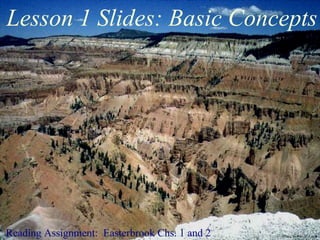
- 1. Reading Assignment: Easterbrook Chs. 1 and 2 Lesson 1 Slides: Basic Concepts Photo by PW. W. Little
- 2. The word “geomorphology" comes from the Greek roots "geo,“ “morph,” and “logos,” meaning “earth,” “form,” and “study,” respectively. Therefore, geomorphology is literally “the study of earth forms.” Geomorphologists are concerned primarily with earth’s surficial features, including their origin, history, composition, and impact on human activity. Geomorphology concentrates primarily on Quaternary (Pleistocene and Holocene) features. Earth’s landforms reflect the local and regional balance between hydrologic and tectonic processes. What is Geomorphology? Photo by NASA
- 3. Supernatural Intervention • Volcanoes and earthquakes are caused by angry gods and/or devils. • Fossils placed by the devil to confuse man. Throughout most of human history, natural phenomena have been interpreted through myths and legends to be the result of supernatural intervention.
- 4. Creationism is the theory that all earth’s features, from grains of sand to mountain ranges, were designed and created individually by God. Creationism
- 5. Photo by W. W. Little Catastrophism vs. Uniformitarianism Early ideas considered geological features, such as mountain ranges, to have been created through sudden, catastrophic, events. Uniformitarianism is the idea that the same physical, chemical, and biological processes operating on and in the earth today were also active in the past and that, therefore, all geologic phenomena can be explained as natural occurrences.
- 6. Scientists make observations of an event or an object and then try to explain those observations by organizing them into a logical system. As rock bodies can cover extensive areas and represent vast periods of time, much of geological research cannot be done as controlled experiments in a formal laboratory setting. In these situations, we rely on the assumption that physical, chemical and biological laws are constant. That is, the processes operating today are the same as those that operated in the past. For instance, since water flows down hill today, it must have done so in the past. Therefore, if we identify a body of rocks that exhibits characteristics similar to those found in a modern geological environment, we assume that it must have formed in a similar manner. Uniformitarianism Ancient river channels Modern river channels Photos by W. W. LittlePhotographer unknown
- 7. • Both sedimentary and igneous rocks were precipitated in a global sea. Erosion was caused by the “rush” of water as the sea receded. • No explanation as to the fate of the missing sea water. Neptunism Abraham Gottlob Werner
- 8. • The ocean floor and continents are both ancient and are fixed in their positions. • Mountain ranges formed through crustal contraction during gradual cooling of a molten planetary surface. Similar to the wrinkling of dried fruit. • Crustal folding and sea-level changes (uplift/subsidence) are due to cooling and contraction of the earth's interior. Shrinking Earth Theory
- 9. Virtually everything we see on the earth's surface is the result of the interaction between two dynamic systems - tectonics and hydrology. Dynamic Systems From Tarbuck and Lutgens
- 10. Plate tectonics is the process by which rock material is moved from within the earth to its surface and, in some cases, back to its interior and by which the lithosphere is broken into a series of plates that move with respect to one another.
- 12. • Driven by the earth's internal heat, which is generated by the radioactive decay of K, U, Th, and other elements; by friction as material moves through the earth, and from residual heat related to planetary accretion. • Responsible for earthquakes, volcanic activity, mountain formation, and continental drift • Builds things up • Primary processes include mantle convection and isostacy Tectonic System Unknown source
- 13. Controlling Factors for Geomorphology Tectonic Factors • Structural style (normal faulting, thrust faulting, folding, vertical uplift) • Plate position (active margin, passive margin, somewhere in between) Hydrologic Factors • Climate (temperature, humidity, atmospheric and oceanic circulation patterns) • Transporting medium (flowing water, ice, wind, waves, tides) Prior Geologic History • Nature of surficial materials • Inherited structures Geomorphology reflects the local and regional balance between tectonic and hydrologic forces.
- 14. Controlling Factors Geomorphic Agents and Processes: Affect how rocks and sediment are eroded and transported. Surficial Materials: Rocks and sediment of different types are located at the earth’s surface. Tectonic Setting: Determines what materials are exposed at the earth’s surface and the manner in which they are distributed. Climate: Determines what geologic agents are available to interact with exposed rock materials and influences the rate of physical and chemical reactions.
- 15. Controlling Factors Geomorphic Agents and Processes: Affect how rocks and sediment are eroded and transported. Surficial Materials: Rocks and sediment of different types are located at the earth’s surface. Tectonic Setting: Determines what materials are exposed at the earth’s surface and the manner in which they are distributed. Climate: Determines what geologic agents are available to interact with exposed rock materials and influences the rate of physical and chemical reactions.
- 16. Tectonic Setting Determines what materials are exposed at the earth’s surface and the manner in which they are distributed.
- 18. There are two major crustal components, continental masses and ocean basins. They differ in elevation, rock type, density, chemical composition, age, and history. Crustal Features
- 19. • Relatively low density rocks derived from felsic and intermediate sources. • Include the oldest rocks on earth (up to 4.0 Ga). • Divided into 4 major components; shields, stable platforms, mountain belts, and continental shelves. Continents Mountain Belt Shield Stable Platform Continental Shelf
- 23. From Tarbuck and Lutgens • Typically found along continental margins • Linear belts of folded sedimentary layers overlying intrusive igneous and metamorphic rocks • Highly deformed by horizontal and vertical forces • Characterized by internal zig-zag pattern • E.g. Rockies and Appalachians Folded Mountain Belts
- 35. • Regional surface of low relief with gentle warping (resembles the shape of a Greco-Roman shield). • Metamorphic and intrusive igneous rocks formed deep within the earth and later elevated to the surface through isostacy as overlying material was eroded. • E.g. Canadian shield Shields
- 42. From Hamblin & Christiansen (2001) • Horizontal and slightly deformed sedimentary layers overlying the shields. • Little deformation or vertical movement over hundreds of millions of years. Can have broad domes and basins • E.g. U.S. Midwest between the Rockies and the Appalachians. Stable Platforms
- 67. Continental shelf • Submerged, flat continental area • Very low seaward gradient • Thick sediment cover obscures complex underlying fault structures. Continental slope • Edge of continental shelf to sea floor. • Steeper than shelf, but still relatively flat. • The base of the slope is known as the continental rise. • Can include thick, fan-shaped deposits formed by submarine "avalanches." Continental Shelves From Tarbuck and Lutgens Continental Shelves and slopes are considered to be parts of continents but form transition zones with ocean basins.
Editor's Notes
- In this first lesson, you will be introduced to the processes that govern the development of earth’s physical features. You will learn that there are two fundamental systems responsible for virtually everything we see at the earth’s surface. These are the tectonic and hydrologic systems. The tectonic system is driven by the earth’s internal heat and tends to build things up, producing angular features. Mountain ranges, earthquakes, volcanoes, island chains, and the break up and drifting of continents are all products of the tectonic system. The hydrologic system receives its energy from the Sun and wears things down, smoothing out the angular features produced by tectonics. Rivers, lakes, sand dunes, glaciers, and beaches are all the result of hydrologic processes. What we see at any one spot on the earth’s surface is the result of the local balance of these two opposing systems. Where the tectonic system dominates, high mountains are formed and shorelines are irregular. The west coasts of North and South America, the island chains of the Pacific Ocean, and the Himalayan Mountain Range are areas dominated by tectonic processes. Areas influenced primarily by hydrologic processes tend to be flatter with relatively smooth coast lines, such as the great plains and Gulf coast of the United States.