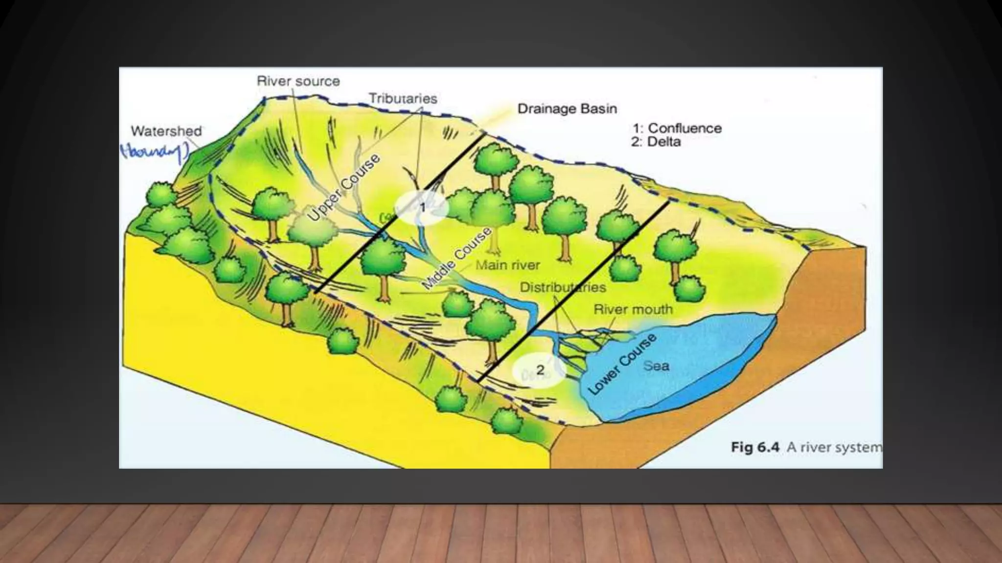
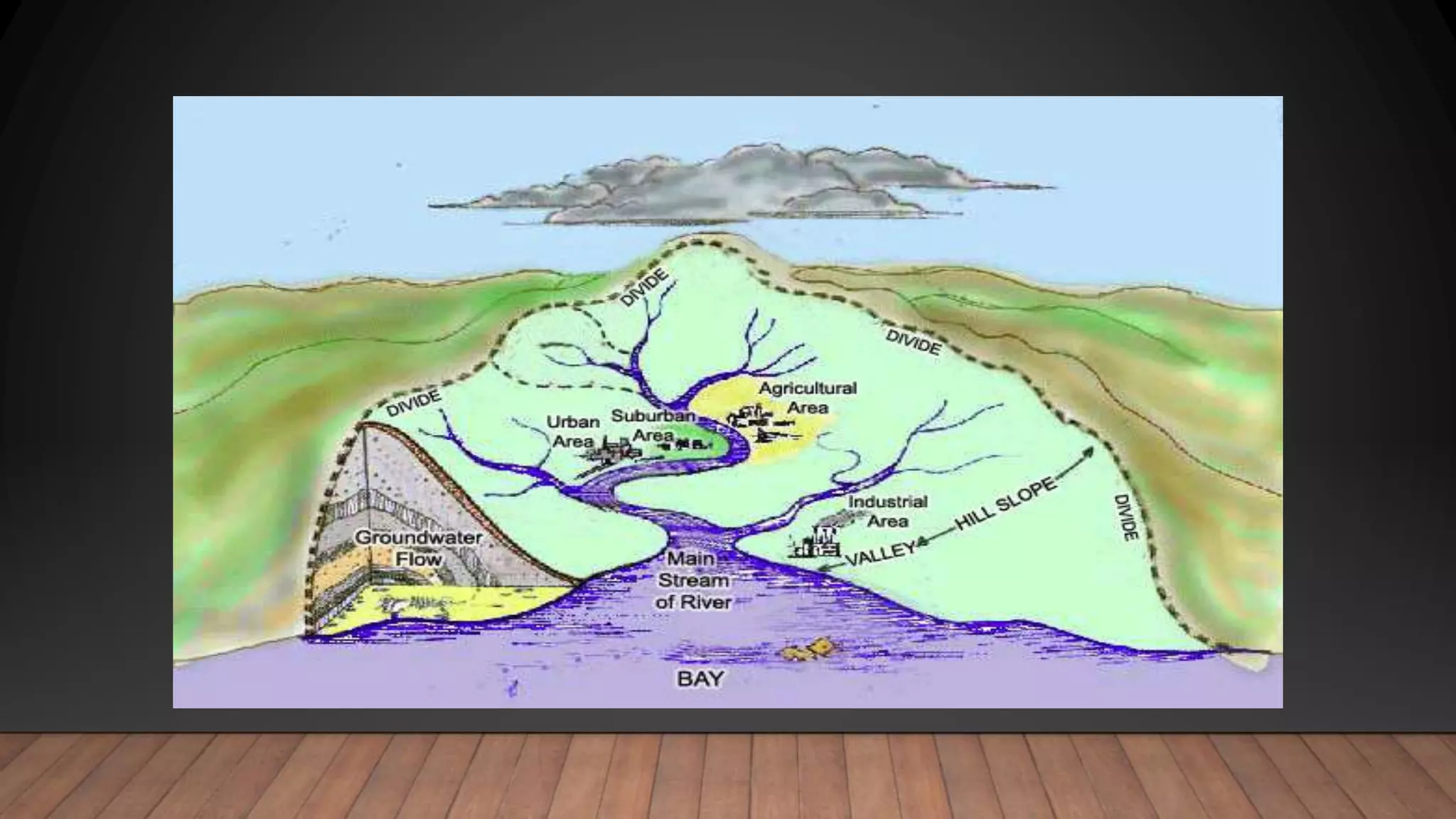
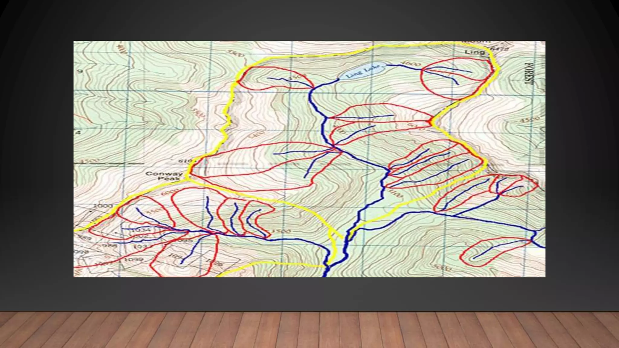
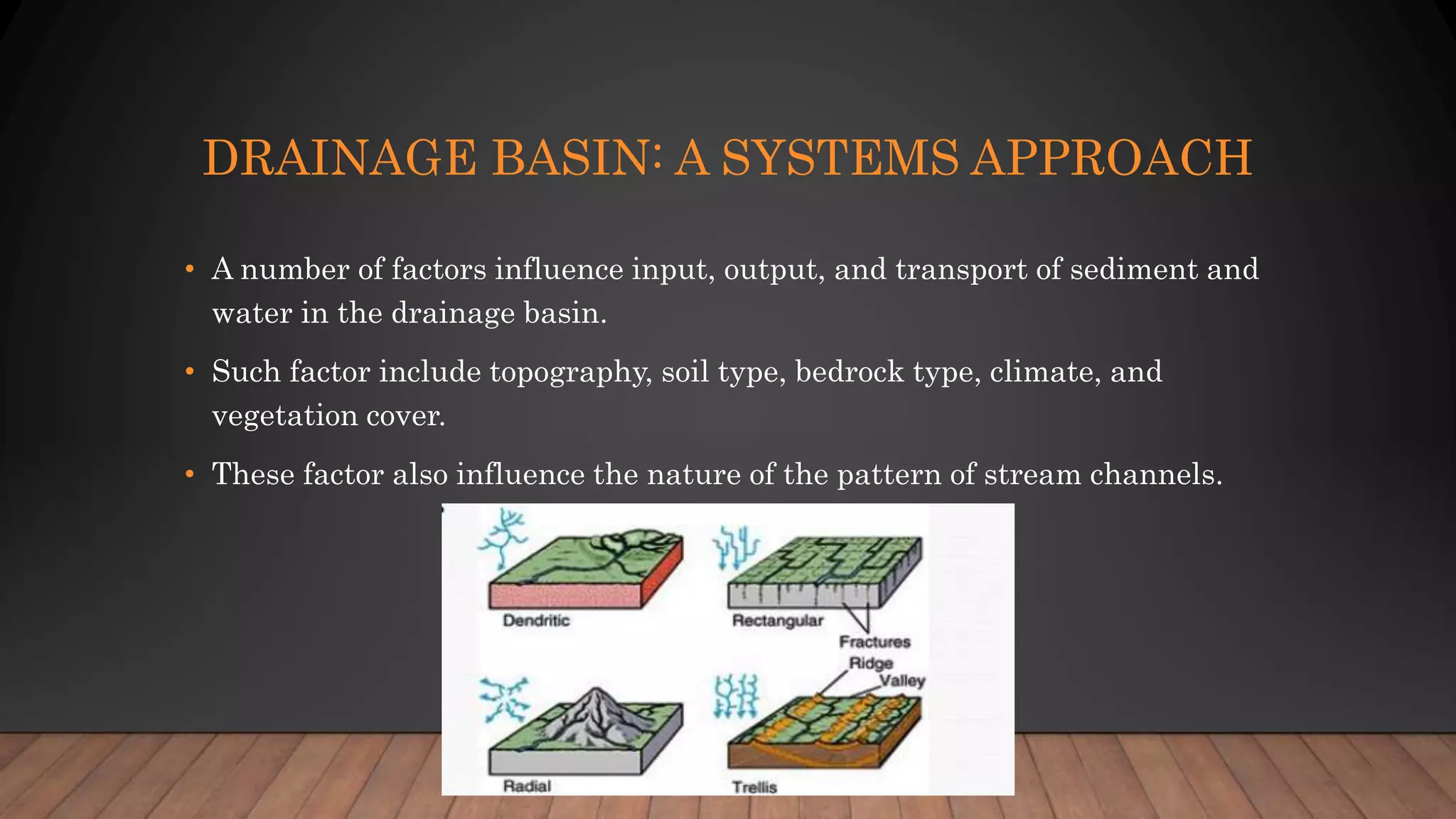
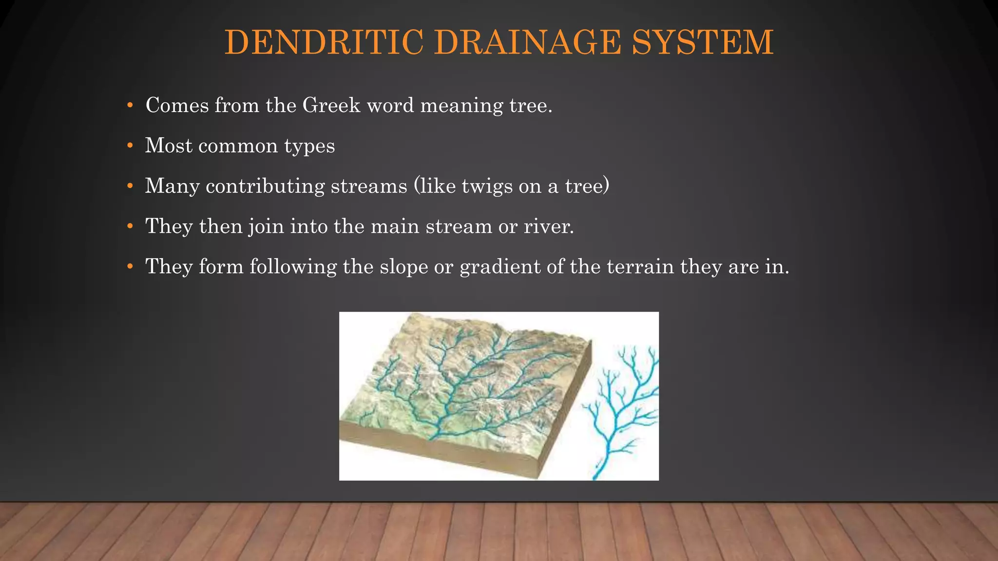
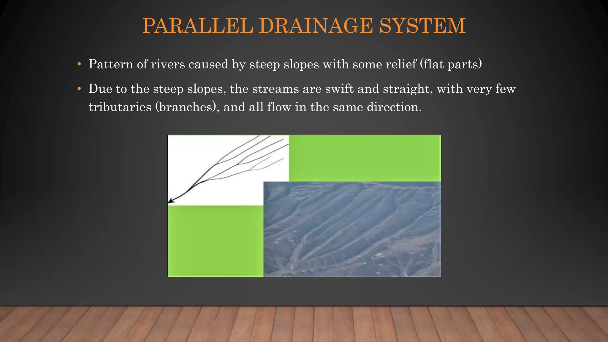
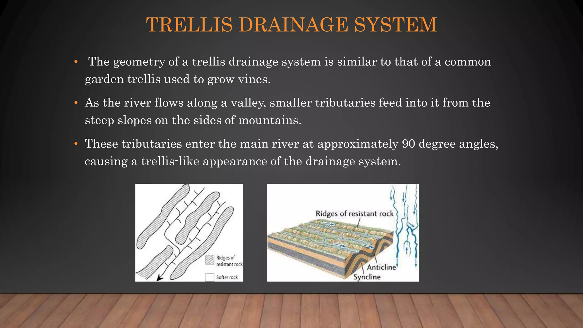
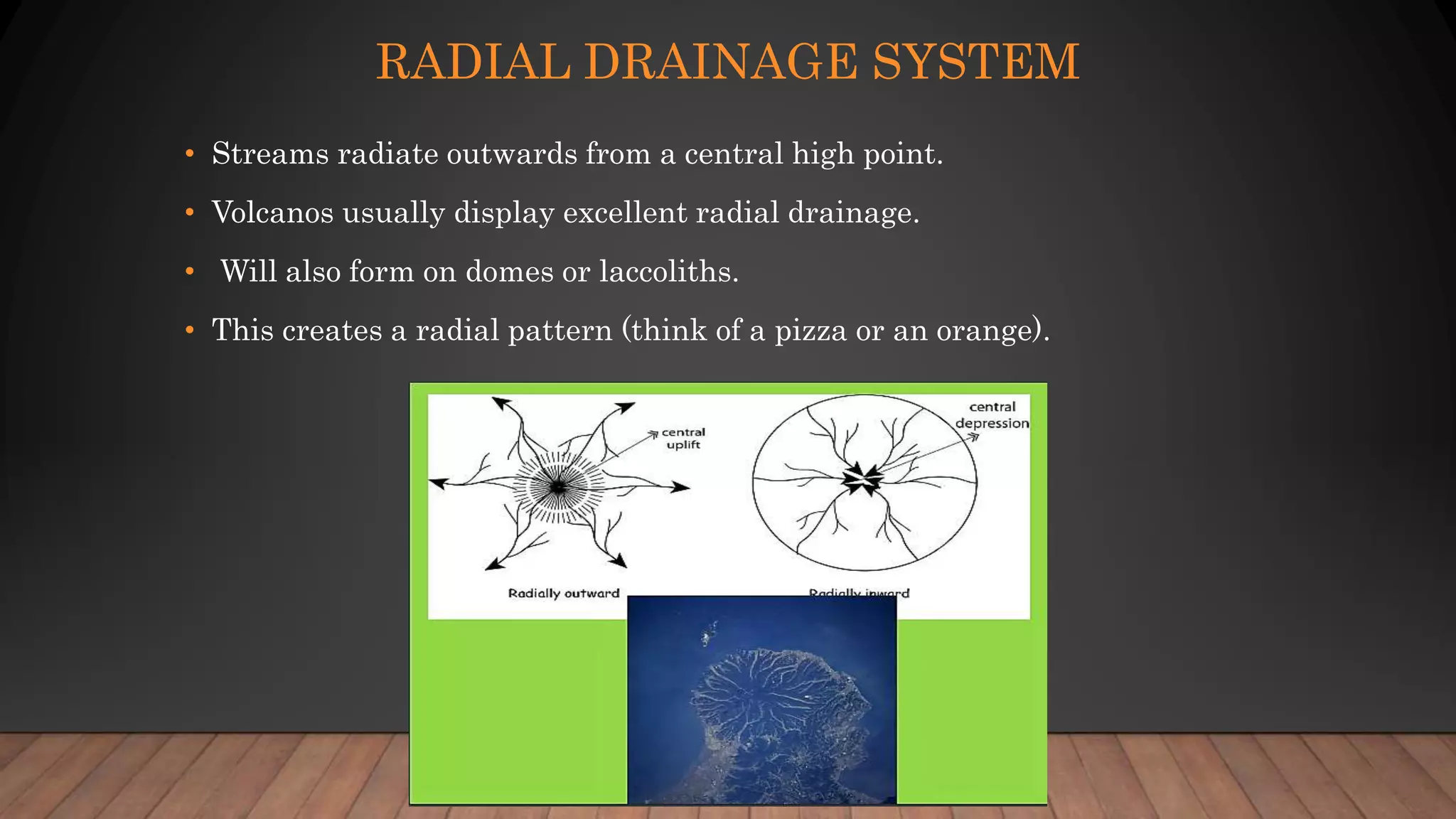
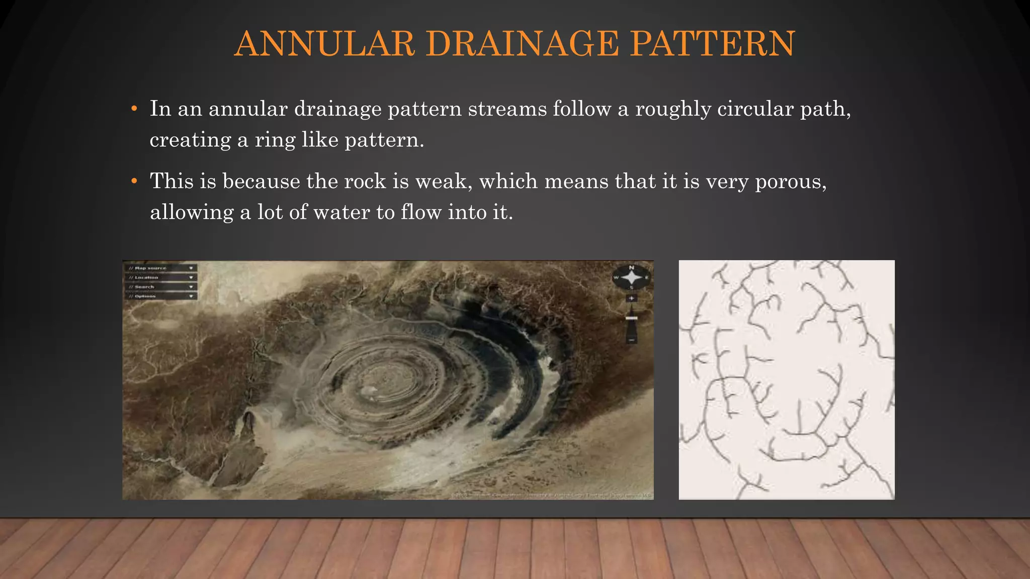
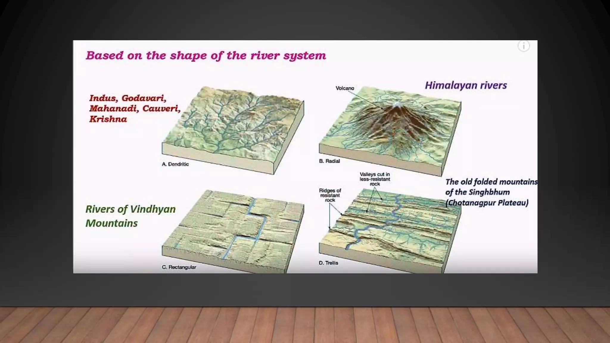
SlideShare a Scribd company logo
DRAINAGE PATTERN & MORPHOMETRIC
ANALYSES OF DRAINAGE BASINS.
Ujjaval Patel
GEL 410
DRAINAGE BASIN
• In geomorphology, the patterns formed by the streams, rivers, and lakes in a
particular drainage basin. Also known as drainage systems or river systems.
• According to the configuration of the channels, drainage systems can fall into one of
several categories known as drainage patterns. Drainage patterns depend on
the topography & geology of the land.
• Drainage basins: The total land surface drained by a system of stream leading to the
same outflow.
• Drainage system: The stream, tributaries, and other bodies of water by which a
region is called drained.
• Drainage divide: The boundary between adjacent drainage basins.
• An area of land drained by a river and its tributaries.
• It is also called the Catchment area.
• Any precipitation which falls into the basin is collected and drains into the main river or its
tributaries by runoff, throughflow or groundwater flow.
• Its boundary marked by a ridge of high land called watershed.
• Drainage basins have one main stream and many tributaries.
• Each tributaries of main stream forms sub-drainage basin.
DRAINAGE BASIN: A SYSTEMS APPROACH
• A number of factors influence input, output, and transport of sediment and
water in the drainage basin.
• Such factor include topography, soil type, bedrock type, climate, and
vegetation cover.
• These factor also influence the nature of the pattern of stream channels.
TYPES OF DRAINAGE SYSTEM
• Drainage systems can fall into one of several categories, depending on the
topography and geology of the land:
• Dendritic drainage pattern.
• Parallel drainage pattern.
• Trellis drainage pattern.
• Rectangular drainage system
• Radial drainage system
• Deranged drainage system
• Annular drainage pattern
DENDRITIC DRAINAGE SYSTEM
• Comes from the Greek word meaning tree.
• Most common types
• Many contributing streams (like twigs on a tree)
• They then join into the main stream or river.
• They form following the slope or gradient of the terrain they are in.
PARALLEL DRAINAGE SYSTEM
• Pattern of rivers caused by steep slopes with some relief (flat parts)
• Due to the steep slopes, the streams are swift and straight, with very few
tributaries (branches), and all flow in the same direction.
TRELLIS DRAINAGE SYSTEM
• The geometry of a trellis drainage system is similar to that of a common
garden trellis used to grow vines.
• As the river flows along a valley, smaller tributaries feed into it from the
steep slopes on the sides of mountains.
• These tributaries enter the main river at approximately 90 degree angles,
causing a trellis-like appearance of the drainage system.
RADIAL DRAINAGE SYSTEM
• Streams radiate outwards from a central high point.
• Volcanos usually display excellent radial drainage.
• Will also form on domes or laccoliths.
• This creates a radial pattern (think of a pizza or an orange).
ANNULAR DRAINAGE PATTERN
• In an annular drainage pattern streams follow a roughly circular path,
creating a ring like pattern.
• This is because the rock is weak, which means that it is very porous,
allowing a lot of water to flow into it.
DRAINAGE BASIN MORPHOMETRY
• Morphometric analysis is refers as the quantitative evaluation of form
characteristics of the earth surface and any landform unit.
• This is the most common technique in basin analysis, as morphometry
form an ideal areal unit for interpretation and analysis of fluvial originated
landforms where they exhibits and example of open systems of operation.
• The composition of the stream system of a drainage basin in expressed
quantitatively with stream order, drainage density, bifurcation ration and
stream length ratio
• It incorporates quantitative study of the various components such as,
stream segments, basin length, basin parameters, basin area, altitude,
volume, slope, profiles of the land which indicates the nature of
development of the basin.
• Stream Order (U)
 Stream Order (U) There are four different system of ordering streams that are
available Gravelius (1914), Horton (1945), Strahler (1952) and Schideggar
(1970). Strahler’s system, which is a slightly modified of Hortons system, has
been followed because of its simplicity. Where the smallest, unbranched
fingertip streams are designated as 1st order, the confluence of two 1st order
channels give a channel segments of 2nd order, two 2nd order streams join to
form a segment of 3rd order and so on. When two channel of different order join
then the higher order is maintained. The trunk stream is the stream segment
of highest order.
• Stream Number (Nu)
 The total number of stream segments present in each order is the stream
number (Nu). Nu is number of streams of order u.
• Stream Length (Lu)
 The total length of individual stream segments of each order is the stream
length of that order. Stream length measures the average (or mean) length of a
stream in each orders, and is calculated by dividing the total length of all
streams in a particular order by the number of streams in that order. The
stream length in each order increases exponentially with increasing stream
order.
• Bifurcation Ratio (Rb)
 The bifurcation ratio is the ratio between the number of streams in one order
and in the next. It is calculated by dividing the number of streams in the lower
by the number in the higher of the two orders; the bifurcation ration of large
basins is generally the average of the bifurcation rations of the stream orders
within it.
𝑅𝑏 = 𝑁𝑢
Nu+1
• Drainage Density (Dd)
• Drainage density has long been recognised as topographic characteristic of fundamental
significance. This arise from that fact that drainage density is sensitive parameter
which in many ways provides the link between the form attributes of the basin and the
processes operating along stream course (Gregory and Welling, 1973). It reflects the
landuse and affects infiltration and the basin response time between precipitation and
discharge. It is also of geomorphological interest particularly for the development of
slopes. Drainage basin with high Dd indicates that a large proportion of the
precipitation runs off. On the other hand, a low drainage density indicates the most
rainfall infiltrates the ground and few channels are required to carry the runoff (Roger,
1971). Dd is considered to be an important index; it is expresses as the ratio of the total
sum of all channel segments within a basin to the basin area i.e., the length of streams
per unit of drainage density. It is a dimension inverse of length (Horton, 1932). Dd is a
measure of the texture of the network, and indicates the balance between the erosive
power of overland flow and the resistance of surface soils and rocks. The factors affecting
drainage density include geology and density of vegetation. The vegetation density
influenced drainage density by binding the surface layer and slows down the rate of
overland flow, and stores some of the water for short periods of time. The effect of
lithology on drainage density is marked. Permeable rocks with a high infiltration rate
reduce overland flow, and consequently drainage density is low.
REFERENCES
• http://shodhganga.inflibnet.ac.in/bitstream/10603/5456/9/09_chapter%205.p
df

More Related Content

What's hot

Fluvial cycle
Fluvial cycleFluvial cycle
Fluvial cycle
Pramoda Raj
 
Geomorphology and its application to hydrogeology
Geomorphology and its application to hydrogeologyGeomorphology and its application to hydrogeology
Geomorphology and its application to hydrogeology
suchi4
 
Fluvial depositional landform geomorphology
Fluvial depositional  landform geomorphologyFluvial depositional  landform geomorphology
Fluvial depositional landform geomorphology
Shivam Jain
 
Types Drainage pattern presentation
Types Drainage pattern presentationTypes Drainage pattern presentation
Types Drainage pattern presentation
Kamrul Islam Karim
 
River Channel Processes & Landforms
River Channel Processes & LandformsRiver Channel Processes & Landforms
River Channel Processes & LandformsMalia Damit
 
Deltas- types, formation, case studies
Deltas- types, formation, case studiesDeltas- types, formation, case studies
Deltas- types, formation, case studies
Nishay Patel
 
Fluvial process
Fluvial processFluvial process
Fluvial process
Pramoda Raj
 
Karst topography
Karst topographyKarst topography
Karst topography
Shivam Jain
 
Geomorphology applications
Geomorphology applicationsGeomorphology applications
Geomorphology applicationsvyshalik
 
Glacial landforms (geomorphology)
Glacial landforms (geomorphology) Glacial landforms (geomorphology)
Glacial landforms (geomorphology)
Shivam Jain
 
morphometry of drainage basin.pptx
morphometry of drainage basin.pptxmorphometry of drainage basin.pptx
morphometry of drainage basin.pptx
soja5
 
Fluvial landforms
Fluvial landformsFluvial landforms
Fluvial landformsMs Geoflake
 
Aerial photographs and their interpretation
Aerial photographs and their interpretationAerial photographs and their interpretation
Aerial photographs and their interpretationSumant Diwakar
 
Fundmetal concepts of geomorphology
Fundmetal concepts of geomorphologyFundmetal concepts of geomorphology
Fundmetal concepts of geomorphology
Nikhil Sherekar
 
Fluvial Morphology Handbook
Fluvial Morphology HandbookFluvial Morphology Handbook
Fluvial Morphology Handbook
Mohammad Mohaiminul Islam
 
Cycle of erosion
Cycle of erosionCycle of erosion
Cycle of erosion
Surabhirani4
 
Drainage pattern
Drainage patternDrainage pattern
Drainage pattern
Md Asif Hasan
 
Periglacial landforms-processes, formation
Periglacial landforms-processes, formationPeriglacial landforms-processes, formation
Periglacial landforms-processes, formation
Nishay Patel
 
Morphogenetic region-Geomorhology Chapter
Morphogenetic region-Geomorhology ChapterMorphogenetic region-Geomorhology Chapter
Morphogenetic region-Geomorhology Chapter
Kaium Chowdhury
 
Introduction to Geomorphology
Introduction to Geomorphology Introduction to Geomorphology
Introduction to Geomorphology
P.K. Mani
 

What's hot (20)

Fluvial cycle
Fluvial cycleFluvial cycle
Fluvial cycle
 
Geomorphology and its application to hydrogeology
Geomorphology and its application to hydrogeologyGeomorphology and its application to hydrogeology
Geomorphology and its application to hydrogeology
 
Fluvial depositional landform geomorphology
Fluvial depositional  landform geomorphologyFluvial depositional  landform geomorphology
Fluvial depositional landform geomorphology
 
Types Drainage pattern presentation
Types Drainage pattern presentationTypes Drainage pattern presentation
Types Drainage pattern presentation
 
River Channel Processes & Landforms
River Channel Processes & LandformsRiver Channel Processes & Landforms
River Channel Processes & Landforms
 
Deltas- types, formation, case studies
Deltas- types, formation, case studiesDeltas- types, formation, case studies
Deltas- types, formation, case studies
 
Fluvial process
Fluvial processFluvial process
Fluvial process
 
Karst topography
Karst topographyKarst topography
Karst topography
 
Geomorphology applications
Geomorphology applicationsGeomorphology applications
Geomorphology applications
 
Glacial landforms (geomorphology)
Glacial landforms (geomorphology) Glacial landforms (geomorphology)
Glacial landforms (geomorphology)
 
morphometry of drainage basin.pptx
morphometry of drainage basin.pptxmorphometry of drainage basin.pptx
morphometry of drainage basin.pptx
 
Fluvial landforms
Fluvial landformsFluvial landforms
Fluvial landforms
 
Aerial photographs and their interpretation
Aerial photographs and their interpretationAerial photographs and their interpretation
Aerial photographs and their interpretation
 
Fundmetal concepts of geomorphology
Fundmetal concepts of geomorphologyFundmetal concepts of geomorphology
Fundmetal concepts of geomorphology
 
Fluvial Morphology Handbook
Fluvial Morphology HandbookFluvial Morphology Handbook
Fluvial Morphology Handbook
 
Cycle of erosion
Cycle of erosionCycle of erosion
Cycle of erosion
 
Drainage pattern
Drainage patternDrainage pattern
Drainage pattern
 
Periglacial landforms-processes, formation
Periglacial landforms-processes, formationPeriglacial landforms-processes, formation
Periglacial landforms-processes, formation
 
Morphogenetic region-Geomorhology Chapter
Morphogenetic region-Geomorhology ChapterMorphogenetic region-Geomorhology Chapter
Morphogenetic region-Geomorhology Chapter
 
Introduction to Geomorphology
Introduction to Geomorphology Introduction to Geomorphology
Introduction to Geomorphology
 

Similar to Drainage pattern & morphometric analyses of drainage basins

drain.pdf
drain.pdfdrain.pdf
drain.pdf
bhvKmrThkr
 
Presentation_Morphometry_pptx.pptx
Presentation_Morphometry_pptx.pptxPresentation_Morphometry_pptx.pptx
Presentation_Morphometry_pptx.pptx
AnirbanKundu36
 
CHARACTERISTICS OF RUNOFF.ppt
CHARACTERISTICS OF RUNOFF.pptCHARACTERISTICS OF RUNOFF.ppt
CHARACTERISTICS OF RUNOFF.ppt
eshitaakter2
 
Sediments transport
Sediments transportSediments transport
Sediments transport
Jyoti Khatiwada
 
Chapter one. River morphology.pptx
Chapter one. River morphology.pptxChapter one. River morphology.pptx
Chapter one. River morphology.pptx
Amanuel Beza
 
Introduction to River Engineering
Introduction to River EngineeringIntroduction to River Engineering
Introduction to River Engineering
ManamnoBeza1
 
Hydrology 1
Hydrology 1Hydrology 1
Hydrology 1
AmanuelGitamo
 
Week2 lecture 3 dredging engineering_13_jun2020
Week2 lecture 3 dredging engineering_13_jun2020Week2 lecture 3 dredging engineering_13_jun2020
Week2 lecture 3 dredging engineering_13_jun2020
Knnt Thein
 
Civil 4th year-2.pptx
Civil 4th year-2.pptxCivil 4th year-2.pptx
Civil 4th year-2.pptx
Amanuel Beza
 
Chapter one. River morphology.pdf
Chapter one. River morphology.pdfChapter one. River morphology.pdf
Chapter one. River morphology.pdf
Amanuel Beza
 
River_Landform.ppt
River_Landform.pptRiver_Landform.ppt
River_Landform.ppt
PapuKumarNaik1
 
River Landforms
River LandformsRiver Landforms
River Landforms
Leonardo Felipe
 
Lec 9 Border irrigation – Design and hydraulics.ppt
Lec 9 Border irrigation – Design and hydraulics.pptLec 9 Border irrigation – Design and hydraulics.ppt
Lec 9 Border irrigation – Design and hydraulics.ppt
pavik13
 
Hydrology and Fluvial Geo morphology for CAMBRIDGE AS level
Hydrology and Fluvial Geo morphology for CAMBRIDGE AS level Hydrology and Fluvial Geo morphology for CAMBRIDGE AS level
Hydrology and Fluvial Geo morphology for CAMBRIDGE AS level
Yonas Gemeda
 
River training work
River training workRiver training work
River training work
Hanamantray sk
 
Rivers and drainage basins n
Rivers and drainage basins nRivers and drainage basins n
Rivers and drainage basins n
NishaviRanasinghe
 
Bentuk bentang alam fluvial, materi kuliah semester 2
Bentuk bentang alam fluvial, materi kuliah semester 2Bentuk bentang alam fluvial, materi kuliah semester 2
Bentuk bentang alam fluvial, materi kuliah semester 2
Turyadi3
 
1 grassed water ways
1 grassed water ways1 grassed water ways
1 grassed water ways
Md Irfan Ansari
 
Lecture4(hydro)
Lecture4(hydro)Lecture4(hydro)
Lecture4(hydro)mltan4
 
Fluvial Process And Related Land Forms
Fluvial Process And Related Land Forms Fluvial Process And Related Land Forms
Fluvial Process And Related Land Forms sileshi
 

Similar to Drainage pattern & morphometric analyses of drainage basins (20)

drain.pdf
drain.pdfdrain.pdf
drain.pdf
 
Presentation_Morphometry_pptx.pptx
Presentation_Morphometry_pptx.pptxPresentation_Morphometry_pptx.pptx
Presentation_Morphometry_pptx.pptx
 
CHARACTERISTICS OF RUNOFF.ppt
CHARACTERISTICS OF RUNOFF.pptCHARACTERISTICS OF RUNOFF.ppt
CHARACTERISTICS OF RUNOFF.ppt
 
Sediments transport
Sediments transportSediments transport
Sediments transport
 
Chapter one. River morphology.pptx
Chapter one. River morphology.pptxChapter one. River morphology.pptx
Chapter one. River morphology.pptx
 
Introduction to River Engineering
Introduction to River EngineeringIntroduction to River Engineering
Introduction to River Engineering
 
Hydrology 1
Hydrology 1Hydrology 1
Hydrology 1
 
Week2 lecture 3 dredging engineering_13_jun2020
Week2 lecture 3 dredging engineering_13_jun2020Week2 lecture 3 dredging engineering_13_jun2020
Week2 lecture 3 dredging engineering_13_jun2020
 
Civil 4th year-2.pptx
Civil 4th year-2.pptxCivil 4th year-2.pptx
Civil 4th year-2.pptx
 
Chapter one. River morphology.pdf
Chapter one. River morphology.pdfChapter one. River morphology.pdf
Chapter one. River morphology.pdf
 
River_Landform.ppt
River_Landform.pptRiver_Landform.ppt
River_Landform.ppt
 
River Landforms
River LandformsRiver Landforms
River Landforms
 
Lec 9 Border irrigation – Design and hydraulics.ppt
Lec 9 Border irrigation – Design and hydraulics.pptLec 9 Border irrigation – Design and hydraulics.ppt
Lec 9 Border irrigation – Design and hydraulics.ppt
 
Hydrology and Fluvial Geo morphology for CAMBRIDGE AS level
Hydrology and Fluvial Geo morphology for CAMBRIDGE AS level Hydrology and Fluvial Geo morphology for CAMBRIDGE AS level
Hydrology and Fluvial Geo morphology for CAMBRIDGE AS level
 
River training work
River training workRiver training work
River training work
 
Rivers and drainage basins n
Rivers and drainage basins nRivers and drainage basins n
Rivers and drainage basins n
 
Bentuk bentang alam fluvial, materi kuliah semester 2
Bentuk bentang alam fluvial, materi kuliah semester 2Bentuk bentang alam fluvial, materi kuliah semester 2
Bentuk bentang alam fluvial, materi kuliah semester 2
 
1 grassed water ways
1 grassed water ways1 grassed water ways
1 grassed water ways
 
Lecture4(hydro)
Lecture4(hydro)Lecture4(hydro)
Lecture4(hydro)
 
Fluvial Process And Related Land Forms
Fluvial Process And Related Land Forms Fluvial Process And Related Land Forms
Fluvial Process And Related Land Forms
 

Recently uploaded

BÀI TẬP BỔ TRỢ TIẾNG ANH GLOBAL SUCCESS LỚP 3 - CẢ NĂM (CÓ FILE NGHE VÀ ĐÁP Á...
BÀI TẬP BỔ TRỢ TIẾNG ANH GLOBAL SUCCESS LỚP 3 - CẢ NĂM (CÓ FILE NGHE VÀ ĐÁP Á...BÀI TẬP BỔ TRỢ TIẾNG ANH GLOBAL SUCCESS LỚP 3 - CẢ NĂM (CÓ FILE NGHE VÀ ĐÁP Á...
BÀI TẬP BỔ TRỢ TIẾNG ANH GLOBAL SUCCESS LỚP 3 - CẢ NĂM (CÓ FILE NGHE VÀ ĐÁP Á...
Nguyen Thanh Tu Collection
 
Thesis Statement for students diagnonsed withADHD.ppt
Thesis Statement for students diagnonsed withADHD.pptThesis Statement for students diagnonsed withADHD.ppt
Thesis Statement for students diagnonsed withADHD.ppt
EverAndrsGuerraGuerr
 
Supporting (UKRI) OA monographs at Salford.pptx
Supporting (UKRI) OA monographs at Salford.pptxSupporting (UKRI) OA monographs at Salford.pptx
Supporting (UKRI) OA monographs at Salford.pptx
Jisc
 
Mule 4.6 & Java 17 Upgrade | MuleSoft Mysore Meetup #46
Mule 4.6 & Java 17 Upgrade | MuleSoft Mysore Meetup #46Mule 4.6 & Java 17 Upgrade | MuleSoft Mysore Meetup #46
Mule 4.6 & Java 17 Upgrade | MuleSoft Mysore Meetup #46
MysoreMuleSoftMeetup
 
The Diamonds of 2023-2024 in the IGRA collection
The Diamonds of 2023-2024 in the IGRA collectionThe Diamonds of 2023-2024 in the IGRA collection
The Diamonds of 2023-2024 in the IGRA collection
Israel Genealogy Research Association
 
Introduction to AI for Nonprofits with Tapp Network
Introduction to AI for Nonprofits with Tapp NetworkIntroduction to AI for Nonprofits with Tapp Network
Introduction to AI for Nonprofits with Tapp Network
TechSoup
 
Multithreading_in_C++ - std::thread, race condition
Multithreading_in_C++ - std::thread, race conditionMultithreading_in_C++ - std::thread, race condition
Multithreading_in_C++ - std::thread, race condition
Mohammed Sikander
 
JEE1_This_section_contains_FOUR_ questions
JEE1_This_section_contains_FOUR_ questionsJEE1_This_section_contains_FOUR_ questions
JEE1_This_section_contains_FOUR_ questions
ShivajiThube2
 
Biological Screening of Herbal Drugs in detailed.
Biological Screening of Herbal Drugs in detailed.Biological Screening of Herbal Drugs in detailed.
Biological Screening of Herbal Drugs in detailed.
Ashokrao Mane college of Pharmacy Peth-Vadgaon
 
Lapbook sobre os Regimes Totalitários.pdf
Lapbook sobre os Regimes Totalitários.pdfLapbook sobre os Regimes Totalitários.pdf
Lapbook sobre os Regimes Totalitários.pdf
Jean Carlos Nunes Paixão
 
Acetabularia Information For Class 9 .docx
Acetabularia Information For Class 9  .docxAcetabularia Information For Class 9  .docx
Acetabularia Information For Class 9 .docx
vaibhavrinwa19
 
Model Attribute Check Company Auto Property
Model Attribute  Check Company Auto PropertyModel Attribute  Check Company Auto Property
Model Attribute Check Company Auto Property
Celine George
 
Best Digital Marketing Institute In NOIDA
Best Digital Marketing Institute In NOIDABest Digital Marketing Institute In NOIDA
Best Digital Marketing Institute In NOIDA
deeptiverma2406
 
A Strategic Approach: GenAI in Education
A Strategic Approach: GenAI in EducationA Strategic Approach: GenAI in Education
A Strategic Approach: GenAI in Education
Peter Windle
 
Pride Month Slides 2024 David Douglas School District
Pride Month Slides 2024 David Douglas School DistrictPride Month Slides 2024 David Douglas School District
Pride Month Slides 2024 David Douglas School District
David Douglas School District
 
A Survey of Techniques for Maximizing LLM Performance.pptx
A Survey of Techniques for Maximizing LLM Performance.pptxA Survey of Techniques for Maximizing LLM Performance.pptx
A Survey of Techniques for Maximizing LLM Performance.pptx
thanhdowork
 
The Challenger.pdf DNHS Official Publication
The Challenger.pdf DNHS Official PublicationThe Challenger.pdf DNHS Official Publication
The Challenger.pdf DNHS Official Publication
Delapenabediema
 
1.4 modern child centered education - mahatma gandhi-2.pptx
1.4 modern child centered education - mahatma gandhi-2.pptx1.4 modern child centered education - mahatma gandhi-2.pptx
1.4 modern child centered education - mahatma gandhi-2.pptx
JosvitaDsouza2
 
Unit 8 - Information and Communication Technology (Paper I).pdf
Unit 8 - Information and Communication Technology (Paper I).pdfUnit 8 - Information and Communication Technology (Paper I).pdf
Unit 8 - Information and Communication Technology (Paper I).pdf
Thiyagu K
 
Digital Artifact 1 - 10VCD Environments Unit
Digital Artifact 1 - 10VCD Environments UnitDigital Artifact 1 - 10VCD Environments Unit
Digital Artifact 1 - 10VCD Environments Unit
chanes7
 

Recently uploaded (20)

BÀI TẬP BỔ TRỢ TIẾNG ANH GLOBAL SUCCESS LỚP 3 - CẢ NĂM (CÓ FILE NGHE VÀ ĐÁP Á...
BÀI TẬP BỔ TRỢ TIẾNG ANH GLOBAL SUCCESS LỚP 3 - CẢ NĂM (CÓ FILE NGHE VÀ ĐÁP Á...BÀI TẬP BỔ TRỢ TIẾNG ANH GLOBAL SUCCESS LỚP 3 - CẢ NĂM (CÓ FILE NGHE VÀ ĐÁP Á...
BÀI TẬP BỔ TRỢ TIẾNG ANH GLOBAL SUCCESS LỚP 3 - CẢ NĂM (CÓ FILE NGHE VÀ ĐÁP Á...
 
Thesis Statement for students diagnonsed withADHD.ppt
Thesis Statement for students diagnonsed withADHD.pptThesis Statement for students diagnonsed withADHD.ppt
Thesis Statement for students diagnonsed withADHD.ppt
 
Supporting (UKRI) OA monographs at Salford.pptx
Supporting (UKRI) OA monographs at Salford.pptxSupporting (UKRI) OA monographs at Salford.pptx
Supporting (UKRI) OA monographs at Salford.pptx
 
Mule 4.6 & Java 17 Upgrade | MuleSoft Mysore Meetup #46
Mule 4.6 & Java 17 Upgrade | MuleSoft Mysore Meetup #46Mule 4.6 & Java 17 Upgrade | MuleSoft Mysore Meetup #46
Mule 4.6 & Java 17 Upgrade | MuleSoft Mysore Meetup #46
 
The Diamonds of 2023-2024 in the IGRA collection
The Diamonds of 2023-2024 in the IGRA collectionThe Diamonds of 2023-2024 in the IGRA collection
The Diamonds of 2023-2024 in the IGRA collection
 
Introduction to AI for Nonprofits with Tapp Network
Introduction to AI for Nonprofits with Tapp NetworkIntroduction to AI for Nonprofits with Tapp Network
Introduction to AI for Nonprofits with Tapp Network
 
Multithreading_in_C++ - std::thread, race condition
Multithreading_in_C++ - std::thread, race conditionMultithreading_in_C++ - std::thread, race condition
Multithreading_in_C++ - std::thread, race condition
 
JEE1_This_section_contains_FOUR_ questions
JEE1_This_section_contains_FOUR_ questionsJEE1_This_section_contains_FOUR_ questions
JEE1_This_section_contains_FOUR_ questions
 
Biological Screening of Herbal Drugs in detailed.
Biological Screening of Herbal Drugs in detailed.Biological Screening of Herbal Drugs in detailed.
Biological Screening of Herbal Drugs in detailed.
 
Lapbook sobre os Regimes Totalitários.pdf
Lapbook sobre os Regimes Totalitários.pdfLapbook sobre os Regimes Totalitários.pdf
Lapbook sobre os Regimes Totalitários.pdf
 
Acetabularia Information For Class 9 .docx
Acetabularia Information For Class 9  .docxAcetabularia Information For Class 9  .docx
Acetabularia Information For Class 9 .docx
 
Model Attribute Check Company Auto Property
Model Attribute  Check Company Auto PropertyModel Attribute  Check Company Auto Property
Model Attribute Check Company Auto Property
 
Best Digital Marketing Institute In NOIDA
Best Digital Marketing Institute In NOIDABest Digital Marketing Institute In NOIDA
Best Digital Marketing Institute In NOIDA
 
A Strategic Approach: GenAI in Education
A Strategic Approach: GenAI in EducationA Strategic Approach: GenAI in Education
A Strategic Approach: GenAI in Education
 
Pride Month Slides 2024 David Douglas School District
Pride Month Slides 2024 David Douglas School DistrictPride Month Slides 2024 David Douglas School District
Pride Month Slides 2024 David Douglas School District
 
A Survey of Techniques for Maximizing LLM Performance.pptx
A Survey of Techniques for Maximizing LLM Performance.pptxA Survey of Techniques for Maximizing LLM Performance.pptx
A Survey of Techniques for Maximizing LLM Performance.pptx
 
The Challenger.pdf DNHS Official Publication
The Challenger.pdf DNHS Official PublicationThe Challenger.pdf DNHS Official Publication
The Challenger.pdf DNHS Official Publication
 
1.4 modern child centered education - mahatma gandhi-2.pptx
1.4 modern child centered education - mahatma gandhi-2.pptx1.4 modern child centered education - mahatma gandhi-2.pptx
1.4 modern child centered education - mahatma gandhi-2.pptx
 
Unit 8 - Information and Communication Technology (Paper I).pdf
Unit 8 - Information and Communication Technology (Paper I).pdfUnit 8 - Information and Communication Technology (Paper I).pdf
Unit 8 - Information and Communication Technology (Paper I).pdf
 
Digital Artifact 1 - 10VCD Environments Unit
Digital Artifact 1 - 10VCD Environments UnitDigital Artifact 1 - 10VCD Environments Unit
Digital Artifact 1 - 10VCD Environments Unit
 

Drainage pattern & morphometric analyses of drainage basins

  • 1. DRAINAGE PATTERN & MORPHOMETRIC ANALYSES OF DRAINAGE BASINS. Ujjaval Patel GEL 410
  • 2. DRAINAGE BASIN • In geomorphology, the patterns formed by the streams, rivers, and lakes in a particular drainage basin. Also known as drainage systems or river systems. • According to the configuration of the channels, drainage systems can fall into one of several categories known as drainage patterns. Drainage patterns depend on the topography & geology of the land. • Drainage basins: The total land surface drained by a system of stream leading to the same outflow. • Drainage system: The stream, tributaries, and other bodies of water by which a region is called drained. • Drainage divide: The boundary between adjacent drainage basins.
  • 3. • An area of land drained by a river and its tributaries. • It is also called the Catchment area. • Any precipitation which falls into the basin is collected and drains into the main river or its tributaries by runoff, throughflow or groundwater flow. • Its boundary marked by a ridge of high land called watershed. • Drainage basins have one main stream and many tributaries. • Each tributaries of main stream forms sub-drainage basin.
  • 4.
  • 5.
  • 6.
  • 7. DRAINAGE BASIN: A SYSTEMS APPROACH • A number of factors influence input, output, and transport of sediment and water in the drainage basin. • Such factor include topography, soil type, bedrock type, climate, and vegetation cover. • These factor also influence the nature of the pattern of stream channels.
  • 8. TYPES OF DRAINAGE SYSTEM • Drainage systems can fall into one of several categories, depending on the topography and geology of the land: • Dendritic drainage pattern. • Parallel drainage pattern. • Trellis drainage pattern. • Rectangular drainage system • Radial drainage system • Deranged drainage system • Annular drainage pattern
  • 9. DENDRITIC DRAINAGE SYSTEM • Comes from the Greek word meaning tree. • Most common types • Many contributing streams (like twigs on a tree) • They then join into the main stream or river. • They form following the slope or gradient of the terrain they are in.
  • 10. PARALLEL DRAINAGE SYSTEM • Pattern of rivers caused by steep slopes with some relief (flat parts) • Due to the steep slopes, the streams are swift and straight, with very few tributaries (branches), and all flow in the same direction.
  • 11. TRELLIS DRAINAGE SYSTEM • The geometry of a trellis drainage system is similar to that of a common garden trellis used to grow vines. • As the river flows along a valley, smaller tributaries feed into it from the steep slopes on the sides of mountains. • These tributaries enter the main river at approximately 90 degree angles, causing a trellis-like appearance of the drainage system.
  • 12. RADIAL DRAINAGE SYSTEM • Streams radiate outwards from a central high point. • Volcanos usually display excellent radial drainage. • Will also form on domes or laccoliths. • This creates a radial pattern (think of a pizza or an orange).
  • 13. ANNULAR DRAINAGE PATTERN • In an annular drainage pattern streams follow a roughly circular path, creating a ring like pattern. • This is because the rock is weak, which means that it is very porous, allowing a lot of water to flow into it.
  • 14.
  • 15. DRAINAGE BASIN MORPHOMETRY • Morphometric analysis is refers as the quantitative evaluation of form characteristics of the earth surface and any landform unit. • This is the most common technique in basin analysis, as morphometry form an ideal areal unit for interpretation and analysis of fluvial originated landforms where they exhibits and example of open systems of operation. • The composition of the stream system of a drainage basin in expressed quantitatively with stream order, drainage density, bifurcation ration and stream length ratio • It incorporates quantitative study of the various components such as, stream segments, basin length, basin parameters, basin area, altitude, volume, slope, profiles of the land which indicates the nature of development of the basin.
  • 16. • Stream Order (U)  Stream Order (U) There are four different system of ordering streams that are available Gravelius (1914), Horton (1945), Strahler (1952) and Schideggar (1970). Strahler’s system, which is a slightly modified of Hortons system, has been followed because of its simplicity. Where the smallest, unbranched fingertip streams are designated as 1st order, the confluence of two 1st order channels give a channel segments of 2nd order, two 2nd order streams join to form a segment of 3rd order and so on. When two channel of different order join then the higher order is maintained. The trunk stream is the stream segment of highest order. • Stream Number (Nu)  The total number of stream segments present in each order is the stream number (Nu). Nu is number of streams of order u.
  • 17. • Stream Length (Lu)  The total length of individual stream segments of each order is the stream length of that order. Stream length measures the average (or mean) length of a stream in each orders, and is calculated by dividing the total length of all streams in a particular order by the number of streams in that order. The stream length in each order increases exponentially with increasing stream order. • Bifurcation Ratio (Rb)  The bifurcation ratio is the ratio between the number of streams in one order and in the next. It is calculated by dividing the number of streams in the lower by the number in the higher of the two orders; the bifurcation ration of large basins is generally the average of the bifurcation rations of the stream orders within it. 𝑅𝑏 = 𝑁𝑢 Nu+1
  • 18. • Drainage Density (Dd) • Drainage density has long been recognised as topographic characteristic of fundamental significance. This arise from that fact that drainage density is sensitive parameter which in many ways provides the link between the form attributes of the basin and the processes operating along stream course (Gregory and Welling, 1973). It reflects the landuse and affects infiltration and the basin response time between precipitation and discharge. It is also of geomorphological interest particularly for the development of slopes. Drainage basin with high Dd indicates that a large proportion of the precipitation runs off. On the other hand, a low drainage density indicates the most rainfall infiltrates the ground and few channels are required to carry the runoff (Roger, 1971). Dd is considered to be an important index; it is expresses as the ratio of the total sum of all channel segments within a basin to the basin area i.e., the length of streams per unit of drainage density. It is a dimension inverse of length (Horton, 1932). Dd is a measure of the texture of the network, and indicates the balance between the erosive power of overland flow and the resistance of surface soils and rocks. The factors affecting drainage density include geology and density of vegetation. The vegetation density influenced drainage density by binding the surface layer and slows down the rate of overland flow, and stores some of the water for short periods of time. The effect of lithology on drainage density is marked. Permeable rocks with a high infiltration rate reduce overland flow, and consequently drainage density is low.