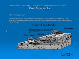
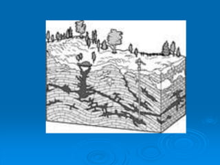
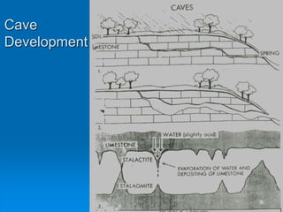
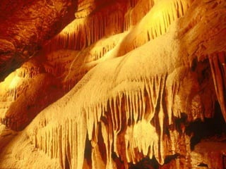
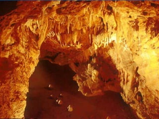
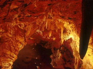
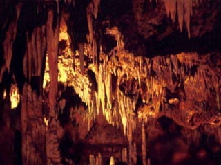
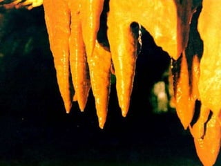
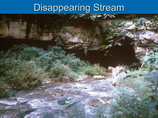
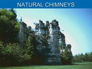
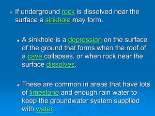
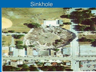
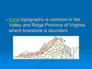
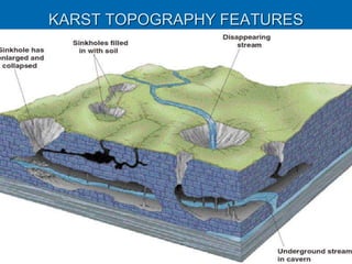
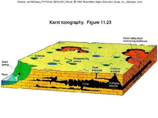
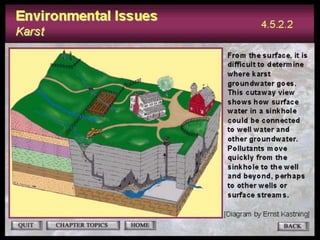
Karst topography develops in areas underlain by carbonate rocks like limestone and dolomite. Groundwater dissolves these rocks by mixing with carbon dioxide to form acidic water, enlarging cracks and creating underground caves and features. Sinkholes can form if underground rock dissolves near the surface or a cave roof collapses. Karst topography is common where sufficient rainfall supplies groundwater that continues dissolving the soluble bedrock over time.
Introduction
In simple words, the term karst describes a distinctive topography that indicates dissolution of underlying soluble rocks by surface water or ground water.
Although commonly associated with carbonate rocks (limestone and dolomite) other highly soluble rocks such as evaporates (gypsum and rock salt) can be sculpted into karst terrain.
Essential conditions
Relatively thick massive soluble rock, i.e., limestone, dolomite, or chalk.
Carbonate rocks should be very close to the ground surface.
Limestone should be highly folded, faulted or fractured.
Considerable relief so that water is capable of circulation to cause typical karst topography.
Moderate to heavy rainfall to cause solution of rocks.
Development of Karst terrain
As rain falls through the atmosphere it picks up carbon dioxide (CO2).
When this rain reaches the ground and passes through the soil it picks up more CO2 and forms a weak solution of carbonic acid.
As the acidified rain water trickles down through cracks in the limestone, it begins to dissolve the rock.
Over time it progressively enlarges the cracks and openings in the ground an underground drainage system starts to develop.
SURFACE FEATURES
Examples of some of the most common surface karst features encountered are as follows:
Sinkhole
A topographically closed depression that is circular or elliptical in shape and with steep to vertical sidewalls.
Karst springs
These are the natural outflows of karst groundwater onto the surface. They form where the water table reaches the surface.
Karst valley:
Larger karst landforms include dry valleys and gorges, carved by past rivers that now flow underground
Solution valley:
The collapse of a cavern over a large area can create a feature referred to as a solution valley or basin, sometimes referred to as a karst gulf
Disappearing Stream:
A stream that disappears into an underground channel and does not reappear in the same, or even in an adjacent, drainage basin.
In karst regions, streams commonly disappear into sinkholes and follow channels through caves.
SUBSURFACE FEATURES
Cave
Karst Caves are voids in the rock that form naturally when water erodes away limestone or other soluble rocks.
Karst caves are shaped by chemical weathering of the bedrock. These formations are commonly found in limestone areas.
Underground Stream:
A body of subsurface water flowing through a cave or a group of communicating caves, as in a karst region
Stalactites:
Stalactites are mineral depositions that originate from the ceiling of a cave and continue to “grow” downward towards the ground.
They are rock formations that have a duct in the center, through which water continues to circulate with minerals.
Stalagmites:
Stalagmites are mineral depositions originated in the floor of a cave and, unlike stalactites; they do not have the central duct such as stalactites
They are usually solid shapes much more rounded and irregular than stalactites.
Karst topography is unique landform that is underground to understand more about this vist my youtube channel
https://youtu.be/PdB_6Ua1ymE
#karst topograpghy #geography
Karst topography is unique landform that is underground to understand more about this vist my youtube channel
https://youtu.be/PdB_6Ua1ymE
#karst topograpghy #geography
About
Indigenized remote control interface card suitable for MAFI system CCR equipment. Compatible for IDM8000 CCR. Backplane mounted serial and TCP/Ethernet communication module for CCR remote access. IDM 8000 CCR remote control on serial and TCP protocol.
• Remote control: Parallel or serial interface.
• Compatible with MAFI CCR system.
• Compatible with IDM8000 CCR.
• Compatible with Backplane mount serial communication.
• Compatible with commercial and Defence aviation CCR system.
• Remote control system for accessing CCR and allied system over serial or TCP.
• Indigenized local Support/presence in India.
• Easy in configuration using DIP switches.
Technical Specifications
Indigenized remote control interface card suitable for MAFI system CCR equipment. Compatible for IDM8000 CCR. Backplane mounted serial and TCP/Ethernet communication module for CCR remote access. IDM 8000 CCR remote control on serial and TCP protocol.
Key Features
Indigenized remote control interface card suitable for MAFI system CCR equipment. Compatible for IDM8000 CCR. Backplane mounted serial and TCP/Ethernet communication module for CCR remote access. IDM 8000 CCR remote control on serial and TCP protocol.
• Remote control: Parallel or serial interface
• Compatible with MAFI CCR system
• Copatiable with IDM8000 CCR
• Compatible with Backplane mount serial communication.
• Compatible with commercial and Defence aviation CCR system.
• Remote control system for accessing CCR and allied system over serial or TCP.
• Indigenized local Support/presence in India.
Application
• Remote control: Parallel or serial interface.
• Compatible with MAFI CCR system.
• Compatible with IDM8000 CCR.
• Compatible with Backplane mount serial communication.
• Compatible with commercial and Defence aviation CCR system.
• Remote control system for accessing CCR and allied system over serial or TCP.
• Indigenized local Support/presence in India.
• Easy in configuration using DIP switches.
Industrial Training at Shahjalal Fertilizer Company Limited (SFCL)MdTanvirMahtab2
This presentation is about the working procedure of Shahjalal Fertilizer Company Limited (SFCL). A Govt. owned Company of Bangladesh Chemical Industries Corporation under Ministry of Industries.
Hierarchical Digital Twin of a Naval Power SystemKerry Sado
A hierarchical digital twin of a Naval DC power system has been developed and experimentally verified. Similar to other state-of-the-art digital twins, this technology creates a digital replica of the physical system executed in real-time or faster, which can modify hardware controls. However, its advantage stems from distributing computational efforts by utilizing a hierarchical structure composed of lower-level digital twin blocks and a higher-level system digital twin. Each digital twin block is associated with a physical subsystem of the hardware and communicates with a singular system digital twin, which creates a system-level response. By extracting information from each level of the hierarchy, power system controls of the hardware were reconfigured autonomously. This hierarchical digital twin development offers several advantages over other digital twins, particularly in the field of naval power systems. The hierarchical structure allows for greater computational efficiency and scalability while the ability to autonomously reconfigure hardware controls offers increased flexibility and responsiveness. The hierarchical decomposition and models utilized were well aligned with the physical twin, as indicated by the maximum deviations between the developed digital twin hierarchy and the hardware.
Immunizing Image Classifiers Against Localized Adversary Attacksgerogepatton
This paper addresses the vulnerability of deep learning models, particularly convolutional neural networks
(CNN)s, to adversarial attacks and presents a proactive training technique designed to counter them. We
introduce a novel volumization algorithm, which transforms 2D images into 3D volumetric representations.
When combined with 3D convolution and deep curriculum learning optimization (CLO), itsignificantly improves
the immunity of models against localized universal attacks by up to 40%. We evaluate our proposed approach
using contemporary CNN architectures and the modified Canadian Institute for Advanced Research (CIFAR-10
and CIFAR-100) and ImageNet Large Scale Visual Recognition Challenge (ILSVRC12) datasets, showcasing
accuracy improvements over previous techniques. The results indicate that the combination of the volumetric
input and curriculum learning holds significant promise for mitigating adversarial attacks without necessitating
adversary training.
CFD Simulation of By-pass Flow in a HRSG module by R&R Consult.pptxR&R Consult
CFD analysis is incredibly effective at solving mysteries and improving the performance of complex systems!
Here's a great example: At a large natural gas-fired power plant, where they use waste heat to generate steam and energy, they were puzzled that their boiler wasn't producing as much steam as expected.
R&R and Tetra Engineering Group Inc. were asked to solve the issue with reduced steam production.
An inspection had shown that a significant amount of hot flue gas was bypassing the boiler tubes, where the heat was supposed to be transferred.
R&R Consult conducted a CFD analysis, which revealed that 6.3% of the flue gas was bypassing the boiler tubes without transferring heat. The analysis also showed that the flue gas was instead being directed along the sides of the boiler and between the modules that were supposed to capture the heat. This was the cause of the reduced performance.
Based on our results, Tetra Engineering installed covering plates to reduce the bypass flow. This improved the boiler's performance and increased electricity production.
It is always satisfying when we can help solve complex challenges like this. Do your systems also need a check-up or optimization? Give us a call!
Work done in cooperation with James Malloy and David Moelling from Tetra Engineering.
More examples of our work https://www.r-r-consult.dk/en/cases-en/
1. A COMMON TOPOGRAPHIC FEATURE EFFECT BY POROSITY AND PERMEABILITY IS……
Karst Topography
What is Karst topography?
topography developed in areas underlain by carbonate rocks, including limestone and dolomite. Karst
topography includes features like caves and sinkholes and forms when limestone is slowly dissolved away by
slightly acidic groundwater.
2.
3. Groundwater mixes with carbon dioxide to
form carbonic acid.
Limestone is a rock that is easily dissolved
by carbonic acid.
As the acidic groundwater moves through
pores in limestone, the rock dissolves,
enlarging cracks until an underground
opening called a cave is formed.
4. Groundwater not only dissolves limestone
to make caves, but it also can make
deposits on the insides of caves.
Water dripping from the cave walls
contains calcium ions dissolved from the
limestone. If the water evaporates while
hanging from the ceiling, the calcium
carbonate is left behind and builds up to
form a stalactite.
Where water drops fall to the floor, a
stalagmite forms.
17. If underground rock is dissolved near the
surface a sinkhole may form.
A sinkhole is a depression on the surface
of the ground that forms when the roof of
a cave collapses, or when rock near the
surface dissolves.
These are common in areas that have lots
of limestone and enough rain water to
keep the groundwater system supplied
with water.
23. Human Impact on Groundwater
Groundwater accounts for 20% of all water
used in the U.S.
Unwise use of this valuable resource can
damage or deplete groundwater reservoirs
Some of the problems related to groundwater
use include:
overpumping-lowering the water table
subsidence
contamination
24.
25. Pollutants
Contaminants introduced at the land surface may
infiltrate to the water table and flow towards a point
of discharge, either the well or the stream.
26. A SOURCE OF GROUNDWATER
CONTAMINATION: SEPTIC TANKS