The water cycle recycles the Earth's water supply, with water evaporating from oceans, lakes and vegetation before condensing into clouds and falling as precipitation. Most of the Earth's water is saltwater, while just over 1% is fresh surface and groundwater. Groundwater is stored in aquifers underground, where it is recharged through infiltration and flows through porous rock, being pumped up by wells. However, overuse and pollution threaten this important freshwater resource.
This document provides an overview of key concepts about rivers and water systems from an Earth Science textbook. It begins by describing how moving water causes erosion and shapes the landscape. It explains the water cycle and defines important river features like tributaries, watersheds, and gradients. Later sections discuss how rivers deposit sediment to form features like deltas and floodplains. It also explains groundwater systems, describing aquifers, springs, wells, and how erosion can form caves and sinkholes. The document concludes by discussing water pollution, water treatment, and conservation strategies.
Solution caves are the most common type of cave, formed by groundwater dissolving carbonate rocks like limestone along joints and fractures. The document discusses four main types of caves - solution caves, lava tubes, sea caves eroded by wave action, and glacier caves formed by meltwater. It also covers related topics like karst terrain and its significance for infrastructure planning, as well as cave formation processes and risks of building in cave-prone coastal areas.
Groundwater is water located beneath the Earth's surface that saturates pores and fractures in rock and soil. It is the largest supply of fresh water available for human use. Groundwater occurs naturally and is replenished through precipitation, though the amount that can be accessed through wells varies significantly between locations. It is stored in porous geologic formations called aquifers and can be confined by layers of impermeable rock. Wells are constructed to access groundwater from aquifers, with casing, screens, grout and gravel packs used to properly construct the well. Groundwater can become contaminated if wells are improperly built or toxic materials leak into the ground near a well.
This document provides an overview of key concepts in hydrogeology and groundwater measurement methods. It defines groundwater as water held within saturated rock beneath the land surface. It describes the hydrologic cycle and how water moves through the unsaturated and saturated zones. It then discusses the different types of aquifers (unconfined and confined) and how groundwater flows within them. The document also explains how to measure groundwater levels using piezometers and wells, and the importance of understanding where the measurement is taken within the subsurface.
Groundwater exists below the Earth's surface within the pore spaces and fractures of rocks and sediments. It originates from rainfall and snowmelt that percolates underground, where it moves slowly through the saturated zone and eventually resurfaces in streams, lakes, or oceans. The movement and storage of groundwater is dependent on the porosity, permeability, and saturation of geological formations. When groundwater is pumped from wells faster than it can recharge, water tables decline and other issues like land subsidence can occur. Groundwater supports various geological features and processes near the surface.
Groundwater is water located beneath the Earth's surface. It is replenished by precipitation and flows slowly through pores and cracks in rock, filling aquifers. The water table marks the top of the saturated zone where all pores are filled. Factors like slope and permeability affect flow rate. Wells tap into aquifers for water access. Springs occur where aquifers meet the surface. Heavy pumping can lower water tables and cause land subsidence if withdrawal exceeds recharge. Groundwater pollution stems from agriculture, dumps, and industry. Geothermal energy harnesses underground heat to generate electricity.
The document provides information on groundwater including:
1. Groundwater is water found underground in soil and rock cracks and spaces called aquifers. It is stored and moves slowly through these geologic formations.
2. Groundwater exists below the land surface in saturated zones called aquifers. The upper boundary is the water table. Wells tap into groundwater by drawing water up from aquifers.
3. Groundwater is an important natural resource and water source where surface water is scarce. Proper treatment is needed for both groundwater and surface water to provide safe drinking water.
Prentice Hall Earth Science ch06 Surface Water, Ground WaterTim Corner
The document discusses the water cycle and processes involved like evaporation, transpiration, precipitation, infiltration, and runoff. It describes how streams erode, transport sediments through dissolved, suspended and bed loads, and deposit materials in deltas. The characteristics of streams like gradient, discharge, meanders, and cutoffs are explained. Groundwater is discussed, including the zones of aeration and saturation, and the movement of groundwater through porous and permeable rocks and sediments within aquifers. Wells, cones of depression, and groundwater contamination are also summarized. Karst topography, sinkholes, caves, and cave formations like stalagmites and stalactites are defined.
Here are the answers to the quiz questions:
1. From Well A to Well B
2. 3 m/1000 m = 0.003
3. 0.003 * 10 m/day = 0.03 m/day = 0.03 m3/day
4. 25%
5. The remaining 50 mL of water is held in the pores by capillary forces.
6. Less, since clay has lower porosity than sand
7. Less, since clay has lower specific yield than sand
8. True
9. False
10. False
11. True
12. Stream Depletion Factors are used to assess the effects of well pumping on stream flow. They depend on
Here are the answers to the quiz questions:
1. Groundwater is flowing from Well A to Well B.
2. The hydraulic gradient is (102 m - 105 m) / 1000 m = 0.003
3. The flux is q = K i = 10 m/day * 0.003 = 0.03 m/day
4. The porosity is 250 mL / 1000 mL = 25%
5. The remaining 50 mL of water is held in the material by capillary forces.
6. The porosity would be less for clay than sand.
7. Less water would pour out if we use clay instead of sand.
8. [T/F] An aquiclude is
Groundwater is water found underground in soil and rock formations. It is stored and moves slowly through aquifers, which are geologic formations containing porous rock or sediment. Less than 1% of the total water on Earth is groundwater, yet it amounts to 40 times more water than all freshwater lakes and streams combined. Groundwater is replenished by rainfall and flows very slowly through the subsurface, influenced by surface topography. The water table marks the upper boundary of saturated groundwater and determines the depth at which wells can access this resource. Groundwater is a crucial source of fresh water for drinking and agriculture.
This document discusses groundwater and its importance as a resource. It provides definitions of key groundwater concepts like aquifers, porosity, permeability and describes how groundwater moves underground slowly through the pores and cracks in soil, sand and rock. It notes that while vast, groundwater supplies are not unlimited, and overuse has led to issues like land subsidence and saltwater intrusion in many areas. The document outlines where groundwater is typically found and how it is distributed, and explains factors that influence groundwater storage and movement.
This document discusses groundwater and its importance as a resource. It provides definitions of key groundwater concepts like aquifers, porosity, permeability and describes how groundwater moves underground slowly through the pores and cracks in soil, sand and rock. It notes that while vast, groundwater supplies are not unlimited, and overuse has led to issues like land subsidence and saltwater intrusion in many areas. The document also describes different groundwater features like springs, geysers and the formation of cones of depression around wells.
This document provides a preliminary investigation of the underground water supply for the hamlet of Waye. It summarizes that the three houses in Waye are each supplied by their own dug wells about 10 meters deep in fractured granite. The wells were likely sited where intermittent springs originally occurred. Rainwater percolates through different saturation zones in the bedrock to replenish the groundwater. Modern water usage risks exceeding the sustainable yield of the wells. Immediate remedies include water conservation measures, while longer-term options could include deepening the wells, drilling boreholes, or connecting to the public water system.
- A drainage basin is the area of land where rain and snowmelt drains into a body of water, such as a river, lake, reservoir or sea.
- Larger drainage basins contain many tributaries that feed into the main river channel. This increases the risk of flooding.
- Impermeable rock and soil, steep slopes, deforestation and heavy rainfall all increase surface runoff in a drainage basin, raising flood risk. Controlling land use and replanting trees can help reduce this.
Groundwater is water found below the Earth's surface. It occupies pore spaces in rocks and soil. There are three main types of aquifers - confined, unconfined, and semi-confined. Confined aquifers are bounded above and below by layers of rock that do not allow water to move through them easily. Unconfined aquifers have a layer of permeable rock or soil at the top that allows water to recharge. Semi-confined aquifers have a layer of low permeability at the top. Important properties of aquifers include porosity, specific yield, hydraulic conductivity, and the type and permeability of the rock material.
The document summarizes the structure and distribution of Earth's hydrosphere. It notes that oceans contain 97% of the planet's water, with the remaining 3% consisting of fresh water found primarily as ice (2.3%), groundwater (0.4%), and surface fresh water (0.05%). It describes the locations and characteristics of oceans, ice, fresh water in rivers, lakes, groundwater aquifers, and wetlands.
This document discusses groundwater concepts including:
- Groundwater occurs below the earth's surface and its movement is controlled by the porosity and permeability of geological materials.
- Aquifers are geological formations that yield significant water quantities while aquitards impede groundwater movement.
- The water table delineates the saturated and unsaturated zones. It fluctuates seasonally and due to pumping which causes cones of depression.
- Groundwater flow depends on factors like hydraulic gradients, bedding planes, faults and the permeability of geological materials.
The document discusses various topics related to hydrology and oceanography. It defines hydrology as the study of Earth's water in its different states and how it circulates between oceans, atmosphere, and land. It also defines oceanography as the scientific study of oceans, their physical and biological properties, and the ocean floor. It outlines the major water reservoirs on Earth and describes the water cycle and groundwater systems.
Earth has a unique combination of water in its atmosphere, oceans, and land. The water cycle describes the continuous movement of water on, above, and below the Earth's surface through different states of matter and includes precipitation, infiltration, storage, and evaporation. Below the surface, groundwater flows through zones of saturation and aeration within permeable rocks and soils called aquifers, eventually emerging in springs, streams or being used by humans.
This document discusses groundwater and aquifers. It defines groundwater as water located below the earth's surface in spaces between rock particles and fractures. Precipitation infiltrates through the unsaturated zone and collects in the saturated zone below. The saturated zone contains groundwater, which can be extracted via wells. Groundwater flow is described by Darcy's Law, with velocity proportional to hydraulic gradient. Groundwater generally flows from areas of high elevation to low elevation, following the slope of the water table. The document also defines different types of aquifers and their characteristics, including unconfined, confined, perched, and artesian aquifers. Wells can tap unconfined or confined groundwater sources.
The document summarizes the drilling of a borehole at Waye Cottage to supplement the existing domestic water supply. A 69m deep borehole was drilled into the granite bedrock and intercepted groundwater at multiple fractures. Initial testing found the borehole could supply over 14,000 liters of water per day. Water quality testing revealed higher than recommended levels of manganese, aluminum, and iron that required treatment equipment. The total cost of drilling and completing the borehole well was £4,467.01.
- 97% of Earth's water is salt water found in oceans and seas, while only 3% is freshwater. Most freshwater is frozen in glaciers and ice sheets near the poles.
- Water cycles between the hydrosphere (oceans, lakes, rivers, atmosphere, and land) through the processes of evaporation, transpiration, condensation, and precipitation. This is known as the water or hydrologic cycle.
- The water cycle involves water evaporating from surfaces, transpiring from plants, condensing in clouds, and falling as precipitation to then collect and flow across the land and into oceans, only to repeat the cycle.
- 97% of Earth's water is salt water found in oceans and seas, while only 3% is freshwater. Most freshwater is frozen in glaciers and polar ice caps.
- Water cycles between the hydrosphere (oceans, lakes, rivers, atmosphere, and land) through the processes of evaporation, transpiration, condensation, and precipitation. This is known as the water or hydrologic cycle.
- The document discusses the water cycle in detail and provides examples of how it can be observed, such as through the formation and evaporation of puddles. It also defines the four processes involved and how they work.
This document discusses groundwater and lakes. It begins by explaining the water cycle and how water infiltrates the ground to become groundwater. There are different sources and types of groundwater classified based on their origin, such as meteoric, juvenile, connate, and oceanic water. Factors like climate, slope, vegetation and rock permeability affect the distribution and flow of groundwater. Springs, wells, and artesian basins are also described. Karst landscapes are formed by the dissolution of limestone and features like sinkholes, caves and underground rivers are discussed. Finally, lakes are classified based on their formation from earth movements, erosion, deposition, volcanism, or other processes.
15. the astonishing genesis flood, part 2Ariel Roth
This document discusses evidence for the Genesis Flood described in the Bible. It summarizes five pieces of evidence from the document:
1) Abundant marine sediments are found on continents, which is unusual since continents normally float above denser rocks below oceans. This distribution of sediments is better explained by a worldwide flood bringing ocean sediments inland.
2) Turbidites and other deposits indicating rapid underwater activity and sediment movement are commonly found on continents far from oceans, suggesting past submergence.
3) Sediment layers show continent-wide currents dominated in one direction, rather than local flows in all directions as seen today, further indicating a large-scale catastrophic event.
4) Some fossil layers contain
Gender and Mental Health - Counselling and Family Therapy Applications and In...PsychoTech Services
A proprietary approach developed by bringing together the best of learning theories from Psychology, design principles from the world of visualization, and pedagogical methods from over a decade of training experience, that enables you to: Learn better, faster!
CapTechTalks Webinar Slides June 2024 Donovan Wright.pptxCapitolTechU
Slides from a Capitol Technology University webinar held June 20, 2024. The webinar featured Dr. Donovan Wright, presenting on the Department of Defense Digital Transformation.
How to Manage Reception Report in Odoo 17Celine George
A business may deal with both sales and purchases occasionally. They buy things from vendors and then sell them to their customers. Such dealings can be confusing at times. Because multiple clients may inquire about the same product at the same time, after purchasing those products, customers must be assigned to them. Odoo has a tool called Reception Report that can be used to complete this assignment. By enabling this, a reception report comes automatically after confirming a receipt, from which we can assign products to orders.
Temple of Asclepius in Thrace. Excavation resultsKrassimira Luka
The temple and the sanctuary around were dedicated to Asklepios Zmidrenus. This name has been known since 1875 when an inscription dedicated to him was discovered in Rome. The inscription is dated in 227 AD and was left by soldiers originating from the city of Philippopolis (modern Plovdiv).
🔥🔥🔥🔥🔥🔥🔥🔥🔥
إضغ بين إيديكم من أقوى الملازم التي صممتها
ملزمة تشريح الجهاز الهيكلي (نظري 3)
💀💀💀💀💀💀💀💀💀💀
تتميز هذهِ الملزمة بعِدة مُميزات :
1- مُترجمة ترجمة تُناسب جميع المستويات
2- تحتوي على 78 رسم توضيحي لكل كلمة موجودة بالملزمة (لكل كلمة !!!!)
#فهم_ماكو_درخ
3- دقة الكتابة والصور عالية جداً جداً جداً
4- هُنالك بعض المعلومات تم توضيحها بشكل تفصيلي جداً (تُعتبر لدى الطالب أو الطالبة بإنها معلومات مُبهمة ومع ذلك تم توضيح هذهِ المعلومات المُبهمة بشكل تفصيلي جداً
5- الملزمة تشرح نفسها ب نفسها بس تكلك تعال اقراني
6- تحتوي الملزمة في اول سلايد على خارطة تتضمن جميع تفرُعات معلومات الجهاز الهيكلي المذكورة في هذهِ الملزمة
واخيراً هذهِ الملزمة حلالٌ عليكم وإتمنى منكم إن تدعولي بالخير والصحة والعافية فقط
كل التوفيق زملائي وزميلاتي ، زميلكم محمد الذهبي 💊💊
🔥🔥🔥🔥🔥🔥🔥🔥🔥
This presentation was provided by Racquel Jemison, Ph.D., Christina MacLaughlin, Ph.D., and Paulomi Majumder. Ph.D., all of the American Chemical Society, for the second session of NISO's 2024 Training Series "DEIA in the Scholarly Landscape." Session Two: 'Expanding Pathways to Publishing Careers,' was held June 13, 2024.
3. Groundwater moves slowly. 1 mm –
1.6 km per day
Spring—where water table meets
surface
Groundwater helps keep rivers, lakes
and wetlands full of water
Groundwater—water
under the ground where
the soil is completely
filled with water.
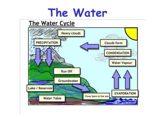
6. Zone of Aeration: area where the pore
spaces in the rock/soil are empty of water
Zone of Saturation: area where the pore
spaces in the rock/soil are filled with water
Water Table: boundary between zone of
saturation & zone of aeration; wells must go
below the water table to reach water
Vocabulary
7. Porosity: the
percent of a
material’s volume
that is pore space
Permeability: how
quickly water can travel
through a material
Porosity and Permeability
12. Page 304 of your textbook…
2. What rock typically makes
up the upper impermeable
layer?
3. What type of sediment is
that rock make from?
4. The ________ in the
aquifer is under
_____________ and may
________ upwards when
an ___________ well is
drilled.
1. What is an artesian formation?
21. Stalactites ‘hold on tight’ to the ceiling while stalagmites are on
the cavern floor.
The Stalactite results from dripping
water (infiltrating) through the cavern
ceiling. With it, it brings calcium
carbonate, or calcite, in it. Over time,
this deposits as each drip hardens.
22. Karst Topography
Overhead view of sinkholes filled with
water in Turkey
An area with lots of
sinkholes & fissures
in the ground where
it has collapsed into
limestone caverns
formed when acidic
water dissolved the
limestone.
23.
24. Step 1: Acidic groundwater dissolves
limestone. Then the water table drops,
leaving empty caves.
Development of Karst Topography
Step 2: Ground above the caves is
eroded away.
Step 3: Thin rock above the cave
collapses, creating a sinkhole.
29. Video Clip here Flooding from tropical storm Agatha caused an enormous
sinkhole that swallowed a building in Guatemala City
30.
31.
32.
33. WATER REVIEW!!!!
Objective: To construct a 10-question multiple
choice quiz focused on the Water material. All
questions must be in multiple choice format. You
must include 3 to 4 possible answers for each
question. CIRCLE THE CORRECT ANSWER
FOR EACH ONE. Include at least 1 diagram.
Chapter 13 Surface Water, 5 Questions
Chapter 14, Ground Water, 5 Questions
STAPLE THIS HAND-WRITTEN PAGE TO
THE END OF YOUR TAKE-HOME UNIT.
34. CONGRATS.. YOU ARE
FINISHED!
• Double-check that all portions of your take-
home packet are filled in correctly.
• Make sure your 10-question review quiz is
stapled at the end (and written neatly).
• BE CAREFUL IN THAT ALL WORK
YOU SUBMIT IS INDIVIDUAL AND
SHOULD NOT BE COMPLETED AS A
GROUP EFFORT.