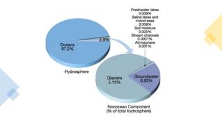
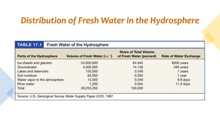
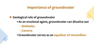
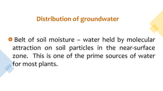
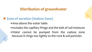
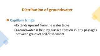
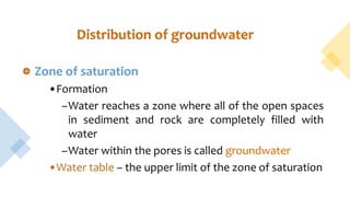
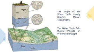
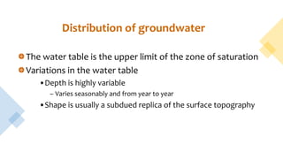
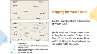
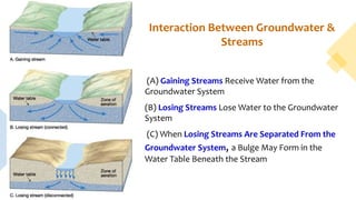
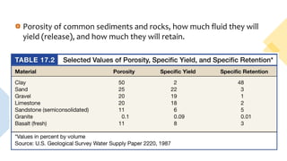
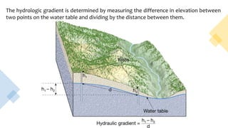
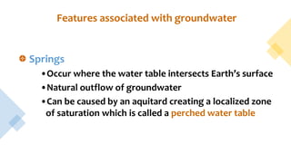
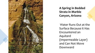
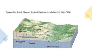
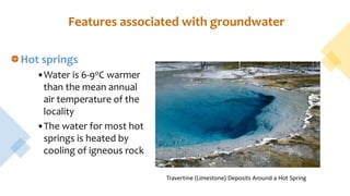
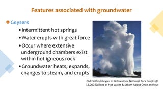
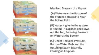
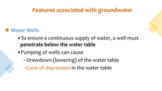
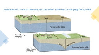
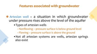
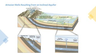
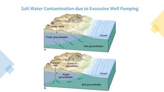
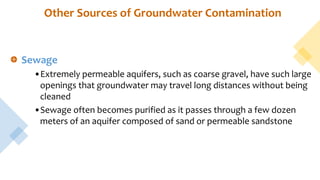
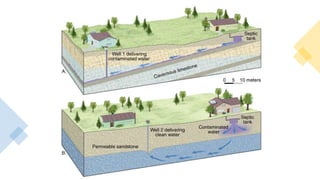
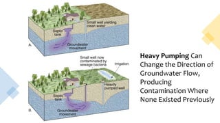
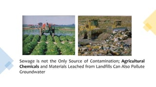
Alzaiem Alazhari University
Faculty of engineering
Civil Engineering Department
Eng. Majzoob Mohammed Arbab
30 August 2022
‫الرحيم‬ ‫الرحمن‬ ‫هللا‬ ‫بسم‬
Engineering Geology
Groundwater
Importance of groundwater
Groundwater is water found in the pores of soil,
sediment & rocks; it also occurs in narrow fractures in
bedrock
Groundwater is the largest reservoir of fresh water that
is readily available to humans
Distribution of Fresh Water in the Hydrosphere
Importance of groundwater
Geological role of groundwater
•As an erosional agent, groundwater can dissolve out
–Sinkholes
–Caverns
•Groundwater serves as an equalizer of streamflow
Distribution of groundwater
Belt of soil moisture – water held by molecular
attraction on soil particles in the near-surface
zone. This is one of the prime sources of water
for most plants.
Distribution of groundwater
Zone of aeration (Vadose Zone)
•Area above the water table
•Includes the capillary fringe and the belt of soil moisture
•Water cannot be pumped from the vadose zone
because it clings too tightly to the rock & soil particles
Capillary fringe
•Extends upward from the water table
•Groundwater is held by surface tension in tiny passages
between grains of soil or sediment
Distribution of groundwater
Zone of saturation
•Formation
–Water reaches a zone where all of the open spaces
in sediment and rock are completely filled with
water
–Water within the pores is called groundwater
•Water table – the upper limit of the zone of saturation
Distribution of groundwater
The Shape of the
Water Table Usually
Roughly Mimics
Topography.
The Water Table Falls
During Periods of
Prolonged Drought
The water table is the upper limit of the zone of saturation
Variations in the water table
•Depth is highly variable
– Varies seasonably and from year to year
•Shape is usually a subdued replica of the surface topography
Distribution of groundwater
The water table
Variations in the water table
•Factors that contribute to the irregular surface of the water
table
–Water tends to “pile up” or build up beneath high areas
(topographic “highs”)
–Variations in rainfall
–Variations in permeability from place to place
Mapping the Water Table
(A) Plot Well Locations & Elevations
of Water Table
(B) Draw Water Table Contour Lines
at Regular Intervals. Dashed Lines
Show Projected Groundwater Flow,
Which Is Roughly Perpendicular to
the Water Table Contours.
The water table
Interaction between groundwater and streams
•Constitutes a basic link in the hydrologic cycle
•Three types of interactions
–Gaining streams – gain water from the inflow of groundwater
through the streambed
–Losing streams – lose water to the groundwater system by
outflow through the streambed
Interaction Between Groundwater &
Streams
(A) Gaining Streams Receive Water from the
Groundwater System
(B) Losing Streams Lose Water to the Groundwater
System
(C) When Losing Streams Are Separated From the
Groundwater System, a Bulge May Form in the
Water Table Beneath the Stream
The water table
Interaction between groundwater and streams
•Combinations
–A combination of the first two – a stream gains in some
sections and loses in other areas
–Most streams are “combinations”
Factors influencing the storage and movement of
groundwater
Porosity – percentage of total volume of rock or sediment
that consists of pore spaces
•Determines how much groundwater can be stored
•Variations can be considerable over short distances
Porosity of common sediments and rocks, how much fluid they will
yield (release), and how much they will retain.
Factors influencing the storage and movement
of groundwater
Permeability, aquitards, and aquifers
•Permeability – the ability of a material to transmit a fluid
•Aquitard (SEAL) – an impermeable layer that hinders or
prevents water movement (such as clay)
•Aquifer (RESERVOIR) – permeable rock strata or sediment
that transmits groundwater freely (such as sands and
gravels)
Movement of groundwater
Exceedingly slow – typical rate of movement is a few
centimeters per day.
Energy for the movement is provided by the force of
gravity.
Darcy’s Law – if permeability remains uniform, the
velocity of groundwater will increase as the slope of
the water table increases.
Movement of groundwater
Darcy’s Law
•Hydraulic gradient – the water table slope, determined
by dividing the vertical difference between the recharge
and discharge points by the length of flow between
these points
•Hydraulic head – the vertical difference between the
recharge and discharge points
The hydrologic gradient is determined by measuring the difference in elevation between
two points on the water table and dividing by the distance between them.
Features associated with groundwater
Springs
•Occur where the water table intersects Earth’s surface
•Natural outflow of groundwater
•Can be caused by an aquitard creating a localized zone
of saturation which is called a perched water table
A Spring in Bedded
Strata in Marble
Canyon, Arizona
Water Runs Out at the
Surface Because it Has
Encountered an
Aquitard
(Impermeable Layer)
and Can Not Move
Downward
Springs Can Result When an Aquitard Creates a Locally Perched Water Table
Features associated with groundwater
Hot springs
•Water is 6-9oC warmer
than the mean annual
air temperature of the
locality
•The water for most hot
springs is heated by
cooling of igneous rock
Travertine (Limestone) Deposits Around a Hot Spring
Features associated with groundwater
Geysers
•Intermittent hot springs
•Water erupts with great force
•Occur where extensive
underground chambers exist
within hot igneous rock
•Groundwater heats, expands,
changes to steam, and erupts
Old Faithful Geyser in Yellowstone National Park Erupts @
12,000 Gallons of Hot Water & Steam About Once an Hour
Idealized Diagram of a Geyser
(A) Water near the Bottom of
the System is Heated to Near
the Boiling Point
(B) Water Higher in the system
is Heated. It Expands and Flows
out the Top, Reducing Pressure
on Water at the Bottom
(C) Under Reduced Pressure,
Bottom Water Boils and the
Resulting Steam Expands,
Causing an Eruption
Features associated with groundwater
Water Wells
•To ensure a continuous supply of water, a well must
penetrate below the water table
•Pumping of wells can cause
–Drawdown (lowering) of the water table
–Cone of depression in the water table
Formation of a Cone of Depression in the Water Table due to Pumping from a Well
Features associated with groundwater
Artesian well – a situation in which groundwater
under pressure rises above the level of the aquifer
•Types of artesian wells
–Nonflowing – pressure surface is below ground level
–Flowing – pressure surface is above the ground
•Not all artesian systems are wells, artesian springs
also exist
Artesian Wells Resulting from an Inclined Aquifer
Problems associated with groundwater withdrawal
Treating groundwater as a nonrenewable resource
• In many places the water available to recharge the aquifer falls
significantly short of the amount being withdrawn
Subsidence
• Ground sinks when water is pumped from wells faster than natural
recharge processes can replace it (San Joaquin Valley of California)
Saltwater contamination
• Excessive groundwater withdrawal causes saltwater to be drawn into
wells, thus contaminating the freshwater supply This is primarily a
problem is coastal areas
Salt Water Contamination due to Excessive Well Pumping
Other Sources of Groundwater Contamination
Sewage
•Extremely permeable aquifers, such as coarse gravel, have such large
openings that groundwater may travel long distances without being
cleaned
•Sewage often becomes purified as it passes through a few dozen
meters of an aquifer composed of sand or permeable sandstone
Groundwater contamination
Sinking a well can lead to groundwater pollution problems
Other sources and types of contamination include substances
such as
•Highway salt
•Fertilizers
•Pesticides
•Chemical and industrial materials
Heavy Pumping Can
Change the Direction of
Groundwater Flow,
Producing
Contamination Where
None Existed Previously
Sewage is not the Only Source of Contamination; Agricultural
Chemicals and Materials Leached from Landfills Can Also Pollute
Groundwater
Questions?
Eng geology Lec III.pptx

Eng geology Lec III.pptx

  • 1.
    Alzaiem Alazhari University Facultyof engineering Civil Engineering Department Eng. Majzoob Mohammed Arbab 30 August 2022 ‫الرحيم‬ ‫الرحمن‬ ‫هللا‬ ‫بسم‬ Engineering Geology Groundwater
  • 2.
    Importance of groundwater Groundwateris water found in the pores of soil, sediment & rocks; it also occurs in narrow fractures in bedrock Groundwater is the largest reservoir of fresh water that is readily available to humans
  • 4.
    Distribution of FreshWater in the Hydrosphere
  • 5.
    Importance of groundwater Geologicalrole of groundwater •As an erosional agent, groundwater can dissolve out –Sinkholes –Caverns •Groundwater serves as an equalizer of streamflow
  • 6.
    Distribution of groundwater Beltof soil moisture – water held by molecular attraction on soil particles in the near-surface zone. This is one of the prime sources of water for most plants.
  • 7.
    Distribution of groundwater Zoneof aeration (Vadose Zone) •Area above the water table •Includes the capillary fringe and the belt of soil moisture •Water cannot be pumped from the vadose zone because it clings too tightly to the rock & soil particles
  • 8.
    Capillary fringe •Extends upwardfrom the water table •Groundwater is held by surface tension in tiny passages between grains of soil or sediment Distribution of groundwater
  • 9.
    Zone of saturation •Formation –Waterreaches a zone where all of the open spaces in sediment and rock are completely filled with water –Water within the pores is called groundwater •Water table – the upper limit of the zone of saturation Distribution of groundwater
  • 10.
    The Shape ofthe Water Table Usually Roughly Mimics Topography. The Water Table Falls During Periods of Prolonged Drought
  • 11.
    The water tableis the upper limit of the zone of saturation Variations in the water table •Depth is highly variable – Varies seasonably and from year to year •Shape is usually a subdued replica of the surface topography Distribution of groundwater
  • 12.
    The water table Variationsin the water table •Factors that contribute to the irregular surface of the water table –Water tends to “pile up” or build up beneath high areas (topographic “highs”) –Variations in rainfall –Variations in permeability from place to place
  • 13.
    Mapping the WaterTable (A) Plot Well Locations & Elevations of Water Table (B) Draw Water Table Contour Lines at Regular Intervals. Dashed Lines Show Projected Groundwater Flow, Which Is Roughly Perpendicular to the Water Table Contours.
  • 14.
    The water table Interactionbetween groundwater and streams •Constitutes a basic link in the hydrologic cycle •Three types of interactions –Gaining streams – gain water from the inflow of groundwater through the streambed –Losing streams – lose water to the groundwater system by outflow through the streambed
  • 15.
    Interaction Between Groundwater& Streams (A) Gaining Streams Receive Water from the Groundwater System (B) Losing Streams Lose Water to the Groundwater System (C) When Losing Streams Are Separated From the Groundwater System, a Bulge May Form in the Water Table Beneath the Stream
  • 16.
    The water table Interactionbetween groundwater and streams •Combinations –A combination of the first two – a stream gains in some sections and loses in other areas –Most streams are “combinations”
  • 17.
    Factors influencing thestorage and movement of groundwater Porosity – percentage of total volume of rock or sediment that consists of pore spaces •Determines how much groundwater can be stored •Variations can be considerable over short distances
  • 18.
    Porosity of commonsediments and rocks, how much fluid they will yield (release), and how much they will retain.
  • 19.
    Factors influencing thestorage and movement of groundwater Permeability, aquitards, and aquifers •Permeability – the ability of a material to transmit a fluid •Aquitard (SEAL) – an impermeable layer that hinders or prevents water movement (such as clay) •Aquifer (RESERVOIR) – permeable rock strata or sediment that transmits groundwater freely (such as sands and gravels)
  • 20.
    Movement of groundwater Exceedinglyslow – typical rate of movement is a few centimeters per day. Energy for the movement is provided by the force of gravity. Darcy’s Law – if permeability remains uniform, the velocity of groundwater will increase as the slope of the water table increases.
  • 21.
    Movement of groundwater Darcy’sLaw •Hydraulic gradient – the water table slope, determined by dividing the vertical difference between the recharge and discharge points by the length of flow between these points •Hydraulic head – the vertical difference between the recharge and discharge points
  • 22.
    The hydrologic gradientis determined by measuring the difference in elevation between two points on the water table and dividing by the distance between them.
  • 23.
    Features associated withgroundwater Springs •Occur where the water table intersects Earth’s surface •Natural outflow of groundwater •Can be caused by an aquitard creating a localized zone of saturation which is called a perched water table
  • 24.
    A Spring inBedded Strata in Marble Canyon, Arizona Water Runs Out at the Surface Because it Has Encountered an Aquitard (Impermeable Layer) and Can Not Move Downward
  • 25.
    Springs Can ResultWhen an Aquitard Creates a Locally Perched Water Table
  • 26.
    Features associated withgroundwater Hot springs •Water is 6-9oC warmer than the mean annual air temperature of the locality •The water for most hot springs is heated by cooling of igneous rock Travertine (Limestone) Deposits Around a Hot Spring
  • 27.
    Features associated withgroundwater Geysers •Intermittent hot springs •Water erupts with great force •Occur where extensive underground chambers exist within hot igneous rock •Groundwater heats, expands, changes to steam, and erupts Old Faithful Geyser in Yellowstone National Park Erupts @ 12,000 Gallons of Hot Water & Steam About Once an Hour
  • 28.
    Idealized Diagram ofa Geyser (A) Water near the Bottom of the System is Heated to Near the Boiling Point (B) Water Higher in the system is Heated. It Expands and Flows out the Top, Reducing Pressure on Water at the Bottom (C) Under Reduced Pressure, Bottom Water Boils and the Resulting Steam Expands, Causing an Eruption
  • 29.
    Features associated withgroundwater Water Wells •To ensure a continuous supply of water, a well must penetrate below the water table •Pumping of wells can cause –Drawdown (lowering) of the water table –Cone of depression in the water table
  • 30.
    Formation of aCone of Depression in the Water Table due to Pumping from a Well
  • 31.
    Features associated withgroundwater Artesian well – a situation in which groundwater under pressure rises above the level of the aquifer •Types of artesian wells –Nonflowing – pressure surface is below ground level –Flowing – pressure surface is above the ground •Not all artesian systems are wells, artesian springs also exist
  • 32.
    Artesian Wells Resultingfrom an Inclined Aquifer
  • 33.
    Problems associated withgroundwater withdrawal Treating groundwater as a nonrenewable resource • In many places the water available to recharge the aquifer falls significantly short of the amount being withdrawn Subsidence • Ground sinks when water is pumped from wells faster than natural recharge processes can replace it (San Joaquin Valley of California) Saltwater contamination • Excessive groundwater withdrawal causes saltwater to be drawn into wells, thus contaminating the freshwater supply This is primarily a problem is coastal areas
  • 34.
    Salt Water Contaminationdue to Excessive Well Pumping
  • 35.
    Other Sources ofGroundwater Contamination Sewage •Extremely permeable aquifers, such as coarse gravel, have such large openings that groundwater may travel long distances without being cleaned •Sewage often becomes purified as it passes through a few dozen meters of an aquifer composed of sand or permeable sandstone
  • 37.
    Groundwater contamination Sinking awell can lead to groundwater pollution problems Other sources and types of contamination include substances such as •Highway salt •Fertilizers •Pesticides •Chemical and industrial materials
  • 38.
    Heavy Pumping Can Changethe Direction of Groundwater Flow, Producing Contamination Where None Existed Previously
  • 39.
    Sewage is notthe Only Source of Contamination; Agricultural Chemicals and Materials Leached from Landfills Can Also Pollute Groundwater
  • 40.