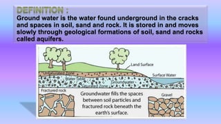
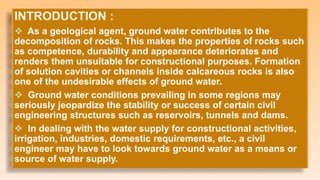
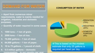
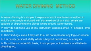
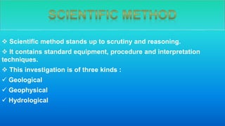
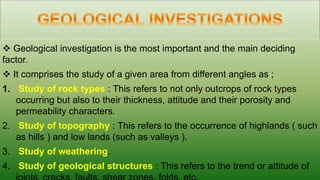
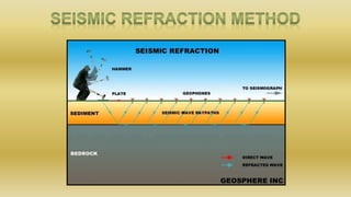
Sheet Pile Wall Design and Construction: A Practical Guide for Civil Engineer...
Ground water
1.
2. Ground water is the water found underground in the cracks
and spaces in soil, sand and rock. It is stored in and moves
slowly through geological formations of soil, sand and rocks
called aquifers.
3. As a geological agent, ground water contributes to the
decomposition of rocks. This makes the properties of rocks such
as competence, durability and appearance deteriorates and
renders them unsuitable for constructional purposes. Formation
of solution cavities or channels inside calcareous rocks is also
one of the undesirable effects of ground water.
Ground water conditions prevailing in some regions may
seriously jeopardize the stability or success of certain civil
engineering structures such as reservoirs, tunnels and dams.
In dealing with the water supply for constructional activities,
irrigation, industries, domestic requirements, etc., a civil
engineer may have to look towards ground water as a means or
source of water supply.
4. Apart from numerous minor
requirements, water is mainly needed for
irrigation, industries and domestic
purposes.
Quantity of water required in some cases
:
1. 1000 tons – 1 ton of grain.
2. 2000 tons – 1 ton of rice.
3. 70,000 gallons – 1 ton of steel.
4. 64,000 gallons – 1 ton of paper.
5. 10 to 75 gallons – 1 pound of cloth.
6. 5.5 million gallons – domestic
CONSUMPTION OF WATER
IRRIGATION
(75%)
INDUSTRIES
(20%)
DOMESTIC
PURPOSE
(5%)
This is based on the modest
estimate that only 25 gallons is
required per head per day.
5. In simple terms, porosity may be
described as the amount of openings
present in a rock.
It may be defined as the “ ratio of the
volume of voids in a rock mass to the total
volume of the rock expressed in
percentage “.
Porosity present in rocks may be either
primary or secondary.
Primary porosity is that which is present
in the rock right from its formation.
Secondary porosity is that which is
present in the rock after the concerned rock
6. Permeability is the ability of the
rock to transmit water through it, i.e.,
permeable rocks allow the water to pass
through them. This property of the rock
is due to interconnected voids present
in the rock. Thus, permeability is
dependent on the porosity character of
the rock.
Factors influencing permeability :
1. Size and shape of constituent grains.
2. Sorting of grains.
3. Continuity and nature of interstices.
7.
8. Zone of saturation :
• The percolation of rain water leads to the development of a zone of
saturation above the bedrock, in which all openings are filled with
water. Such a water is called ground water, in the true sense.
Water table :
• The upper surface of the zone of saturation is called “ water table “.
Zone of aeration :
• Above the zone of saturation and below the ground surface is the
zone of aeration, in which water fills only a portion of the pore space.
9. Types of ground water which
occur in the zone of aeration
1. Soil water
2. Pellicular water
3. Vadose water
4. Perched water
5.Capillary water
1. Unconfined or free ground
water
2. Confined water
3. Fixed ground water
4. Connate water
5. Internal water
6. Juvenile water
Types of ground water which
occur in the zone of saturation
10. Out of different types of ground water, only perched water, free water and
confined water can be utilized under favourable conditions as suitable sources of
water supply.
The usefulness of perched water as a dependable source of water supply is
determined by :
1. The nature, shape and extent of the impermeable barrier on which the
perched water accumulates and
2. The rate of percolation of water in the zone of aeration.
Confined water, can be tapped through artesian wells, springs, and the
amount of water supply from such sources depend on the size and shape of
the aquifer and the recharge or percolation that takes place into it from the
surface.
Free water is the most commonly used type of ground water by digging open
wells or drilling bore wells and penetrating the saturated zone below the water
11. Based on type of ground water
contained, aquifers are named
as ;
Unconfined aquifers
Confined or artesian aquifers
Perched aquifers
12.
13.
14. Definition : The region shaped like an inverted cone in which the
water table is drawn down or depressed in the vicinity of a borehole
from which ground water is being abstracted by pumping.
The shape of this cone of depression on the water table around a
pumped well depends on the permeability nature of the aquifer body.
In case of highly permeable materials, the cone of depression is
nearly flat, while in less permeable aquifers, it is very steep.
The boundary of the cone of depression is known as the ground
water divide.
The area enclosed by the ground water divide is known as the area
of pumping depression.
The distance between the well and ground water divide is termed as
the radius of influence.
15. The radius of influence will be more where the cone of
depression is flat, i.e., in highly permeable aquifers and vice
versa.
The values of the radius of influence in some of the
unconsolidated sediments are as follows :
In coarse gravel = 400 to 800 mts.
In fine gravel to coarse sand = 200 to 400 mts.
In fine sand to medium sand = 100 to 200 mts.
In silt = 30 to 100 mts.
16. Ground water movement in the zone of aeration takes place under the
influence of gravity. But the factors influencing ground water
movement in the zone of saturation are of different kinds. Most of
them are geological and are as follows :
The permeability character of rocks.
The most important geological control is the kind of secondary
porosity associated with the rocks. Well – developed joints, if present,
guide the movement of ground water along their alignment. Faults, if
present also influence the ground water to move along them.
17. Attitude of bedding. If beds occur inclined or folded the percolated
water moves along the bedding planes only, i.e., not vertically
downwards as usual under the influence of gravity.
The buried river channels and unconformities also influence the
ground water movement as they are more porous and permeable.
Relatively small pockets of zones of saturation occur within the
zone of aeration as perched water bodies only due to the prevention
of movement of vadose water by the locally occurring impermeable
formation.
Occurrence of vertical or steeply inclined dolerite dykes, quartz
veins, etc., may act as barriers to the natural flow of ground water
and force it to stop and accumulate on one side of them.
Another important factor which influences ground water movement
is the hydraulic gradient.
18. To explore with the general shortage of water and
growing demands of water, to explore and to
locate places where ground water occurs in plenty,
there are two different approaches :
1. Water divining method
2. Scientific method
19. Water divining is a simple, inexpensive and instantaneous method in
which some people endowed with some extraordinary sixth sense are
capable of pinpointing the places where ground water occurs.
They do not make use of any instrument except a small ‘ Y–shaped ‘ twig
sometimes.
Their findings, even if they are true, do not represent any logic or reason.
It is purely personal ability which is beyond questioning or analysis.
Thus it has no scientific basis, it is improper, not authentic and liable to
cheating too.
20. Scientific method stands up to scrutiny and reasoning.
It contains standard equipment, procedure and interpretation
techniques.
This investigation is of three kinds :
Geological
Geophysical
Hydrological
21. Geological investigation is the most important and the main deciding
factor.
It comprises the study of a given area from different angles as ;
1. Study of rock types : This refers to not only outcrops of rock types
occurring but also to their thickness, attitude and their porosity and
permeability characters.
2. Study of topography : This refers to the occurrence of highlands ( such
as hills ) and low lands (such as valleys ).
3. Study of weathering.
4. Study of geological structures : This refers to the trend or attitude of
22. 5. Study of intrusive rocks : This refers to the occurrence, trend and
extent of dolerite dykes, quartz veins etc.
6. Geological mapping : This of course reveals most of the foregoing field
data and hence is very important.
Drawbacks :
Geological investigations remain incomplete because
i. The outcrops of in situ rocks may be absent or few and widely scattered,
ii. The surface is covered with soil, sediments, etc., and
iii. The rapidly expanding fields of cultivation cover vast areas.
23. Geophysical investigations are made on the surface, quickly,
with the help of some simple portable instruments.
Though there are different types of geophysical methods by
which ground water studies can be made, in more than 80% of the
cases,
“ Electrical Resistivity method “ is employed and in the
remaining cases the “Seismic Refraction method “ is followed.
24.
25. The resistivity method is popular because it is very successful.
This not only helps in determining the aquifer zone but is also helpful in
knowing fresh water and salt water contacts in shore regions.
“ Profiling “ and “ Sounding “ are the two types of resistivity methods
which can be carried out separately or together depending on the necessity.
The fieldwork is done according to the “ Wenner “ or “ Schlumberger “
methods.
The interpretation is made by the “ curve matching method “, “ inverse
slope method “, etc.
The principle involved in resistivity investigation is that subsurface
resistivity is influenced by the rock type, fracturing, moisture content and
salinity of moisture.
26.
27. Seismic investigations depend on the principle that the velocity of shock
waves depends on the fracturing of the medium.
In the compact formations shock waves have a higher velocity than in
their fractured equivalents. Therefore, these investigations are helpful in
detecting subsurface fault zones, shear zones, etc., which are potential
places for ground water occurrence.
Of course, the seismic study only reveals whether fractured zones occur
in an area or not. It does not reveal whether ground water occurs in them or
not.
Geophysical methods also help in locating dolerite dykes, buried river
valleys, etc., which have a significant bearing on ground water movement.
28. Such investigations are relatively simple but very important in the
assessment of the ground water potentially in any region.
1. Study of the water table : In any region, the observation and estimation
of the depth of the static level of water in a number of wells and
borewells offer valuable information about the relative position, the
nature of the slope of the water table and the probable direction of flow
of ground water in an area concerned.
2. Study of surface water bodies : This refers to the occurrence of
networks of streams, ponds, lakes, reservoirs, etc., in the area.
29. 3. Study of springs and seepages : If natural seepages and springs
occur in an area, this indicates a high water table position and rich
ground water conditions. Any alignment of springs indicates faults.
Faulting contributes to rich ground water occurrence.
4. Quality of water : It is necessary to know whether ground water is
potable or not.
5. Study of rainfall, climate, etc. : These details are of a suggestive
nature.
6. Pumping tests : These are very important to know the yield
characteristics of the aquifer concerned. The rates of drawdown
recorded during pumping reveal this information.