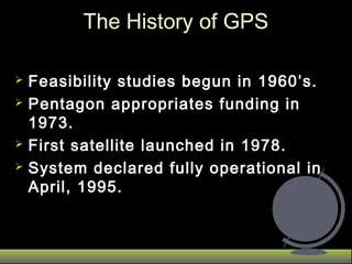
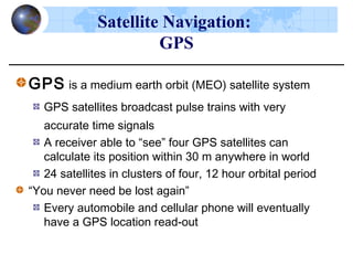
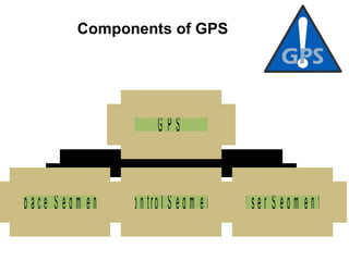
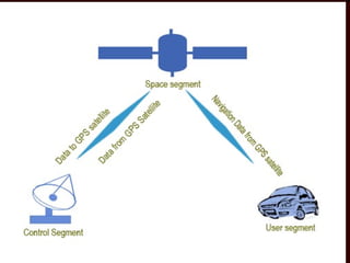
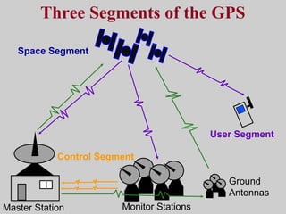
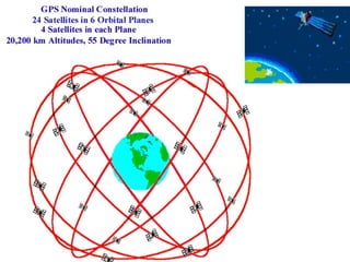
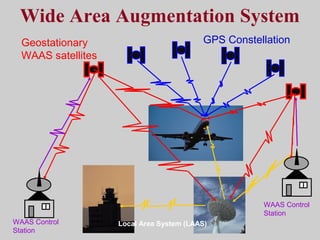
GPS
These applications fall into five :
Location - determining a basic position
Navigation - getting from one location to another
Tracking - monitoring the movement of people/things
Mapping - creating maps of the world
Timing - bringing precise timing to the world
AJAL.A.J
Assistant Professor –Dept of ECE,
Federal Institute of Science And Technology (FISAT)TM
  
 MAIL: ec2reach@gmail.com
Satellite OrbitsSatellite Orbits
F1
(Gravitational
Force)
v (velocity)
Why do satellites stay moving
and in orbit?
F2
(Inertial-Centrifugal
Force)
   
GPS
 Feasibility studies begun in 1960’s.Feasibility studies begun in 1960’s.
 Pentagon appropriates funding inPentagon appropriates funding in
1973.1973.
 First satellite launched in 1978.First satellite launched in 1978.
 System declared fully operational inSystem declared fully operational in
April, 1995.April, 1995.
The History of GPSThe History of GPS
Radio Frequency Spectrum
Commonly Used Bands
AM HF VHF UHF L S C X KuKa V Q
1 10 100 1
MHz GHz
 Terrestrial Bands
Space Bands
Shared (Terrestrial and Space)
SHF
0.1 10010
GPS is a medium earth orbit (MEO) satellite system
GPS satellites broadcast pulse trains with very
accurate time signals
A receiver able to “see” four GPS satellites can
calculate its position within 30 m anywhere in world
24 satellites in clusters of four, 12 hour orbital period
“You never need be lost again”
Every automobile and cellular phone will eventually
have a GPS location read-out
Satellite Navigation:
GPS
   
S p a c e  S e g m e n t C o n tro l S e g m e n t U s e r S e g m e n t
G P S
Components of GPS
   
Control Segment
Space Segment
User Segment
Three Segments of the GPS
Monitor Stations
Ground
Antennas
Master Station
Space Segment:
 24 GPS space vehicles
(SVs). Now 27
 6 orbital planes inclined
at 55 degrees with the
equator.
 This constellation
provides 5 to 8 SVs
from any point on the
earth.
Control Segment
Ground Antenna
Master Control Station
Monitor Station
Functions of
 Master control station estimates parameters
describing satellites' orbit and clock performance,
 It also assesses health status of the satellites and
determines if any re-positioning may be required.
 This information is then returned to three uplink
stations which transmit the information to satellites.
Master Control Station
Functions of
 These stations are the eyes and ears of GPS,
monitoring satellites as they pass overhead by
measuring distances to them every 1.5 seconds
 This data is then smoothed using ionospheric and
meteorological information and sent to Master
Control Station at Colorado Springs.
 The ionospheric and meteorological data is needed
to get more accurate delay measurements, which in
turn improve location estimation.
Monitor Station
Ground Antenna
Ground
Antennas
User segment
GPS antennas & receiver/processors
Position
Velocity
Precise timing
Used by
Aircraft
Ground vehicles
Ships
Individuals
User Segment:
It consists of receivers that decode the signals from the
satellites.
The receiver performs following tasks:
Selecting one or more satellites
Acquiring GPS signals
Measuring and tracking
Recovering navigation data
 Position and coordinates.
 The distance and direction between any two waypoints, or a
position and a waypoint.
 Travel progress reports.
 Accurate time measurement.
Four Basic Functions of GPS
– Each GPS satellite transmits an accurate position and
time signal.
– The user’s receiver measures the time delay for the
signal to reach the receiver.
– Measurements collected from 4 satellites are
processed to solve for the 3D position, velocity and
time.
How does GPS Work?
Sources of Signal Interference
Earth’s Atmosphere
Solid Structures
Metal Electro-magnetic Fields
Planning a Navigation Route
Start
= Waypoint
Ideal Satellite Geometry
N
S
W E
Good Satellite Geometry
Poor Satellite Geometry
N
S
W E
Wide Area Augmentation System
Geostationary
WAAS satellites
GPS Constellation
WAAS Control
Station
Local Area System (LAAS)
WAAS Control
Station
Important Terminology
 Satellite transmits Ephemeris and Almanac Data to
GPS receivers.
Ephemeris data : contains important
information about status of satellite (healthy or
unhealthy), current date and time. This part of signal
is essential for determining a position.
 Almanac data : tells GPS receiver where each
GPS satellite should be at any time throughout day.
Each satellite transmits almanac data showing
orbital information for that satellite and for every
other satellite in the system.
TOA Concept
 GPS uses concept of time of arrival (TOA) of
signals to determine user position.
 This involves measuring time it takes for a signal
transmitted by an emitter (satellite) at a known
location to reach a user receiver.
 Time interval is basically signal propagation time.
 By measuring propagation time of signals
broadcast from multiple satellites at known
locations, receiver can determine its position.
Measuring Distance
 The length of the delay is equal to the signal's travel
time.
 The receiver multiplies this time by the speed of light
to determine how far the signal traveled.
 Assuming the signal traveled
 in a straight line, this is the
 distance from receiver to
 satellite.
Sources of Unintentional
Timing Errors
Typical Errors
Source of Error Typical Error in Meters
(per satellite)
Satellite Clocks 1.5
Orbit Errors 2.5
Ionosphere 5.0
Troposphere 0.5
Receiver Noise 0.3
Multipath 0.6
Real Time CommunicationsReal Time Communications
Local Area
Wireless-RF
Wireless Wide
Area Networks
• UHF/VHF
• GSM
• Satellite
Monitoring
• Container
• Cargo
• Personnel
Logistics
• Inventory Management
• Warehouse Management
• Cross Dock
• Wireless Download
Warehouse/
Hub
Store
GPS
GPS BasedGPS Based ElectronicElectronic DoorDoor LockLock
Container solenoid door lock power up and
data communication receptacle
User Identify GPS based PDA
Having a receptacle to power up
Container electronic door lock
and send GPS data to open door
Electronic Deadbolt lock releases when
Container and hand PDA actual location address is same
as container door lock processor
given destination address
34
N. Sokolova, B.Forssell, HSGPS Tracking Performance in Indoor Environments
GPS Signal Challenges Indoors
• Extremely weak LOS signal
• Shadowing and Fading
effects
• Heavy attenuation
• Multipath (short delay
multipath)
• Signal level differences
• Cross-correlation
problems
• Interference from other RF
systems
• Cellular transmission
• Wireless internet
• Using radio tags to study the physiology, behavior, and demography of
animals
• Telemetry- the transmission of information through the atmosphere
usually by radio waves
Disadvantages-
•high initial costs
•relatively short-lived and applicable to
mammals the size of a wolf or larger or to
birds on which solar cells can be used
Advantages-
•highly accurate
•suited for studies where intensive and
frequent data are needed
•may not require frequent field visits.

Ajal gps

  • 1.
    GPS These applications fallinto five : Location - determining a basic position Navigation - getting from one location to another Tracking - monitoring the movement of people/things Mapping - creating maps of the world Timing - bringing precise timing to the world AJAL.A.J Assistant Professor –Dept of ECE, Federal Institute of Science And Technology (FISAT)TM     MAIL: ec2reach@gmail.com
  • 2.
  • 4.
    F1 (Gravitational Force) v (velocity) Why dosatellites stay moving and in orbit? F2 (Inertial-Centrifugal Force)
  • 5.
  • 6.
     Feasibility studiesbegun in 1960’s.Feasibility studies begun in 1960’s.  Pentagon appropriates funding inPentagon appropriates funding in 1973.1973.  First satellite launched in 1978.First satellite launched in 1978.  System declared fully operational inSystem declared fully operational in April, 1995.April, 1995. The History of GPSThe History of GPS
  • 7.
    Radio Frequency Spectrum CommonlyUsed Bands AM HF VHF UHF L S C X KuKa V Q 1 10 100 1 MHz GHz  Terrestrial Bands Space Bands Shared (Terrestrial and Space) SHF 0.1 10010
  • 8.
    GPS is amedium earth orbit (MEO) satellite system GPS satellites broadcast pulse trains with very accurate time signals A receiver able to “see” four GPS satellites can calculate its position within 30 m anywhere in world 24 satellites in clusters of four, 12 hour orbital period “You never need be lost again” Every automobile and cellular phone will eventually have a GPS location read-out Satellite Navigation: GPS
  • 9.
        S pa c e  S e g m e n t C o n tro l S e g m e n t U s e r S e g m e n t G P S Components of GPS
  • 10.
  • 11.
    Control Segment Space Segment UserSegment Three Segments of the GPS Monitor Stations Ground Antennas Master Station
  • 12.
    Space Segment:  24GPS space vehicles (SVs). Now 27  6 orbital planes inclined at 55 degrees with the equator.  This constellation provides 5 to 8 SVs from any point on the earth.
  • 13.
    Control Segment Ground Antenna MasterControl Station Monitor Station
  • 14.
    Functions of  Mastercontrol station estimates parameters describing satellites' orbit and clock performance,  It also assesses health status of the satellites and determines if any re-positioning may be required.  This information is then returned to three uplink stations which transmit the information to satellites. Master Control Station
  • 15.
    Functions of  Thesestations are the eyes and ears of GPS, monitoring satellites as they pass overhead by measuring distances to them every 1.5 seconds  This data is then smoothed using ionospheric and meteorological information and sent to Master Control Station at Colorado Springs.  The ionospheric and meteorological data is needed to get more accurate delay measurements, which in turn improve location estimation. Monitor Station
  • 16.
  • 17.
    User segment GPS antennas& receiver/processors Position Velocity Precise timing Used by Aircraft Ground vehicles Ships Individuals
  • 18.
    User Segment: It consistsof receivers that decode the signals from the satellites. The receiver performs following tasks: Selecting one or more satellites Acquiring GPS signals Measuring and tracking Recovering navigation data
  • 19.
     Position andcoordinates.  The distance and direction between any two waypoints, or a position and a waypoint.  Travel progress reports.  Accurate time measurement. Four Basic Functions of GPS
  • 20.
    – Each GPSsatellite transmits an accurate position and time signal. – The user’s receiver measures the time delay for the signal to reach the receiver. – Measurements collected from 4 satellites are processed to solve for the 3D position, velocity and time. How does GPS Work?
  • 21.
    Sources of SignalInterference Earth’s Atmosphere Solid Structures Metal Electro-magnetic Fields
  • 22.
    Planning a NavigationRoute Start = Waypoint
  • 23.
  • 24.
  • 25.
  • 26.
    Wide Area AugmentationSystem Geostationary WAAS satellites GPS Constellation WAAS Control Station Local Area System (LAAS) WAAS Control Station
  • 27.
    Important Terminology  Satellitetransmits Ephemeris and Almanac Data to GPS receivers. Ephemeris data : contains important information about status of satellite (healthy or unhealthy), current date and time. This part of signal is essential for determining a position.  Almanac data : tells GPS receiver where each GPS satellite should be at any time throughout day. Each satellite transmits almanac data showing orbital information for that satellite and for every other satellite in the system.
  • 28.
    TOA Concept  GPSuses concept of time of arrival (TOA) of signals to determine user position.  This involves measuring time it takes for a signal transmitted by an emitter (satellite) at a known location to reach a user receiver.  Time interval is basically signal propagation time.  By measuring propagation time of signals broadcast from multiple satellites at known locations, receiver can determine its position.
  • 29.
    Measuring Distance  Thelength of the delay is equal to the signal's travel time.  The receiver multiplies this time by the speed of light to determine how far the signal traveled.  Assuming the signal traveled  in a straight line, this is the  distance from receiver to  satellite.
  • 30.
  • 31.
    Typical Errors Source ofError Typical Error in Meters (per satellite) Satellite Clocks 1.5 Orbit Errors 2.5 Ionosphere 5.0 Troposphere 0.5 Receiver Noise 0.3 Multipath 0.6
  • 32.
    Real Time CommunicationsRealTime Communications Local Area Wireless-RF Wireless Wide Area Networks • UHF/VHF • GSM • Satellite Monitoring • Container • Cargo • Personnel Logistics • Inventory Management • Warehouse Management • Cross Dock • Wireless Download Warehouse/ Hub Store GPS
  • 33.
    GPS BasedGPS BasedElectronicElectronic DoorDoor LockLock Container solenoid door lock power up and data communication receptacle User Identify GPS based PDA Having a receptacle to power up Container electronic door lock and send GPS data to open door Electronic Deadbolt lock releases when Container and hand PDA actual location address is same as container door lock processor given destination address
  • 34.
    34 N. Sokolova, B.Forssell,HSGPS Tracking Performance in Indoor Environments GPS Signal Challenges Indoors • Extremely weak LOS signal • Shadowing and Fading effects • Heavy attenuation • Multipath (short delay multipath) • Signal level differences • Cross-correlation problems • Interference from other RF systems • Cellular transmission • Wireless internet
  • 36.
    • Using radiotags to study the physiology, behavior, and demography of animals • Telemetry- the transmission of information through the atmosphere usually by radio waves
  • 37.
    Disadvantages- •high initial costs •relativelyshort-lived and applicable to mammals the size of a wolf or larger or to birds on which solar cells can be used Advantages- •highly accurate •suited for studies where intensive and frequent data are needed •may not require frequent field visits.

Editor's Notes

  • #21 •Each satellite has it’s own binary code fingerprint (great for computer science) and time is measured using atomic clocks (article from Microgravity news Fall 99) •The idea that it takes 4 satellites to give your latitude, longitude, altutude and velocity is a great lesson in systems…. And solving for the point of intersection of the circles generated by the satellite signal is a great days work. There is a cover article from Mathematics Teacher that takes the students through the process step by step. The article is included in the list of resources in your packet. •You can also use this information to teach triangulation and there is a very nice description of the method on the Craig Haggart webpage inclulded in your packet.