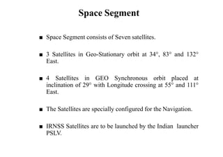
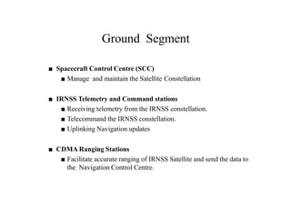
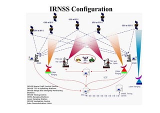
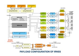
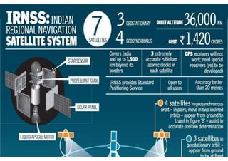
IRNSS is India's independent regional navigation satellite system consisting of seven satellites providing accurate positioning to users in India and within 1500 km of its borders. The system includes space, ground, and user segments. The space segment uses three geostationary and four geosynchronous orbiting satellites. The ground segment controls and maintains the satellites. The user segment utilizes dual-frequency receivers. IRNSS aims to provide positioning accuracy under 20 meters within its coverage area for various navigation and timing applications.
Global positioning system and its mathematical form.
By Mustahsan Khan _ BS(physics-Nanotechnology) (International Islamic University Islamabad) Pakistan.
The Indian Regional Navigation Satellite System or IRNSS is an ingenuously developed Navigation Satellite System that is used to provide accurate real-time positioning and timing services over India and region extending to 1500 km around India. The fully deployed IRNSS system consists of 3 satellites in GEO orbit and 4 satellites in GSO orbit, approximately 36,000 km altitude above earth surface.However, the full system comprises nine satellites, including two on the ground as stand-by.The requirement of such a navigation system is driven because access to foreign government-controlled global navigation satellite systems is not guaranteed in hostile situations, as happened to the Indian military depending on American GPS during the Kargil War.The IRNSS would provide two services, with the Standard Positioning Service open for civilian use, and the Restricted Service (an encrypted one) for authorized users (including the military).
A Comprehending overview of how a GPS (global positioning system) works with a set of satellites ready to provide precision status on location to base station (cell) of user.
#Share the Knowledge
The Global Positioning System (GPS), originally Navstar GPS,[1][2] is a space-based radionavigation system owned by the United States government and operated by the United States Air Force. It is a global navigation satellite system that provides geolocation and time information to a GPS receiver anywhere on or near the Earth where there is an unobstructed line of sight to four or more GPS satellites
IRNSS is an independent regional navigation satellite system developed by India with an operational name of NAVIC ("SAILOR") or "navigator" in Sanskrit, Hindi and many other Indian languages.
Indian Regional Navigational Satellite System (IRNSS)Yelendher Reddy
1. THE BEGINNING
2. WHY?
3. SERVICES
4. ARCHITECTURE
5. SATELLITES
6. IRNSS COVERAGE
7. BENEFITS
Approved by Government of India in May 2006.
The total cost of the project is expected to be ₹1420 crore (US$209 million).
the full system comprises nine satellites.
3 satellites in GEO orbit.
4 satellites in GSO orbit.
2 on the ground as stand-by.
Third country in the world to have it’s own navigational system.
INDIAN REGIONAL NAVIGATIONAL SATELLITE SYSTEM (IRNSS)Yelendher Reddy
1. THE BEGINNING
2. WHY?
3. SERVICES
4. ARCHITECTURE
5. SATELLITES
6. IRNSS COVERAGE
7. BENEFITS
Approved by Government of India in May 2006.
The total cost of the project is expected to be ₹1420 crore (US$209 million).
the full system comprises nine satellites.
3 satellites in GEO orbit.
4 satellites in GSO orbit.
2 on the ground as stand-by.
Third country in the world to have it’s own navigational system.
Indian military depending on American GPS during Wars.
NAVIC (Navigation with Indian Constellation)Mohan Kanni
A small presentation on NAVIC (Navigation with Indian Constellation) on what it consists of and its uses to the country from an ordinary person to commercial business and Military usage For National Security Purposes. Having a Indigenous Navigation system is Vital to country like India due to various prospects.
The Nuclear Suppliers Group (NSG) is a group of nuclear supplier countries that seeks to contribute to the non-proliferation of nuclear weapons through the implementation of two sets of Guidelines for nuclear exports and nuclear-related exports.
India's bid for NSG was stopped by China on 24 Jun 2016
Capital for a company is not usually injected by a single investor. Generally, the capital is brought together from several investors for two reasons – the main reason being the difficulty in finding large amount of money by a single person and the second reason is to spread the business risk among several investors. Copy the link given below and paste it in new browser window to get more information on Present Value:- www.transtutors.com/homework-help/finance/share-pricing.aspx
Put simply, economic models are simplified versions of reality. The situation in any given economy is very complex because there are several variables having great interdependence among them. Copy the link given below and paste it in new browser window to get more information on Economic Models:- www.transtutors.com/homework-help/economics/economic-models.aspx
The Defence Research and Development Organisation (DRDO) is an agency of the Republic of India, charged with the military's research and development, headquartered in New Delhi, India. It was formed in 1958 by the merger of the Technical Development Establishment and the Directorate of Technical Development and Production with the Defence Science Organisation. It is under the administrative control of the Ministry of Defence, Government of India.
NAVIC (Navigation with Indian Constellation) is an Operational name of IRNSS.
Independent Indian Regional Navigation Satellite System
provide accurate position information service to users in India as well as the region extending up to 1500 km from its boundary.
In this Programme there are two levels of service/access to data
1. Standard Positioning Service (SPS)
-which is provided to all the users
2. Restricted Service (RS)
- which is an encrypted service provided only to the authorised users like Indian Security forces.
• NAVIC has total of 7 satellites of which 3 are in GEO (GeoStationary) orbit and 4 are in GSO (GeoSynchronous) orbit.
Global Positioning System . It gives the idea about Global Positioning System. It is one type of satellite made by India. Which means Indian reasearch Navigation 🧭
IRNSS is an independent regional navigation satellite system developed by India with an operational name of NAVIC ("sailor" or "navigator" in Sanskrit, Hindi and many other Indian languages), which also stands for ”NAVigation with Indian Constellation”.
Global Positioning System for College SeminarShaeq Ahmad
Seminar on Global Positioning System
•GPS Segments
•Indian Regional Navigational Satellite System (IRNSS)
•GPS Usage in Palm Jumeirah Archipelago Construction
DevOps and Testing slides at DASA ConnectKari Kakkonen
My and Rik Marselis slides at 30.5.2024 DASA Connect conference. We discuss about what is testing, then what is agile testing and finally what is Testing in DevOps. Finally we had lovely workshop with the participants trying to find out different ways to think about quality and testing in different parts of the DevOps infinity loop.
Kubernetes & AI - Beauty and the Beast !?! @KCD Istanbul 2024Tobias Schneck
As AI technology is pushing into IT I was wondering myself, as an “infrastructure container kubernetes guy”, how get this fancy AI technology get managed from an infrastructure operational view? Is it possible to apply our lovely cloud native principals as well? What benefit’s both technologies could bring to each other?
Let me take this questions and provide you a short journey through existing deployment models and use cases for AI software. On practical examples, we discuss what cloud/on-premise strategy we may need for applying it to our own infrastructure to get it to work from an enterprise perspective. I want to give an overview about infrastructure requirements and technologies, what could be beneficial or limiting your AI use cases in an enterprise environment. An interactive Demo will give you some insides, what approaches I got already working for real.
Software Delivery At the Speed of AI: Inflectra Invests In AI-Powered QualityInflectra
In this insightful webinar, Inflectra explores how artificial intelligence (AI) is transforming software development and testing. Discover how AI-powered tools are revolutionizing every stage of the software development lifecycle (SDLC), from design and prototyping to testing, deployment, and monitoring.
Learn about:
• The Future of Testing: How AI is shifting testing towards verification, analysis, and higher-level skills, while reducing repetitive tasks.
• Test Automation: How AI-powered test case generation, optimization, and self-healing tests are making testing more efficient and effective.
• Visual Testing: Explore the emerging capabilities of AI in visual testing and how it's set to revolutionize UI verification.
• Inflectra's AI Solutions: See demonstrations of Inflectra's cutting-edge AI tools like the ChatGPT plugin and Azure Open AI platform, designed to streamline your testing process.
Whether you're a developer, tester, or QA professional, this webinar will give you valuable insights into how AI is shaping the future of software delivery.
Smart TV Buyer Insights Survey 2024 by 91mobiles.pdf91mobiles
91mobiles recently conducted a Smart TV Buyer Insights Survey in which we asked over 3,000 respondents about the TV they own, aspects they look at on a new TV, and their TV buying preferences.
Key Trends Shaping the Future of Infrastructure.pdfCheryl Hung
Keynote at DIGIT West Expo, Glasgow on 29 May 2024.
Cheryl Hung, ochery.com
Sr Director, Infrastructure Ecosystem, Arm.
The key trends across hardware, cloud and open-source; exploring how these areas are likely to mature and develop over the short and long-term, and then considering how organisations can position themselves to adapt and thrive.
Essentials of Automations: Optimizing FME Workflows with ParametersSafe Software
Are you looking to streamline your workflows and boost your projects’ efficiency? Do you find yourself searching for ways to add flexibility and control over your FME workflows? If so, you’re in the right place.
Join us for an insightful dive into the world of FME parameters, a critical element in optimizing workflow efficiency. This webinar marks the beginning of our three-part “Essentials of Automation” series. This first webinar is designed to equip you with the knowledge and skills to utilize parameters effectively: enhancing the flexibility, maintainability, and user control of your FME projects.
Here’s what you’ll gain:
- Essentials of FME Parameters: Understand the pivotal role of parameters, including Reader/Writer, Transformer, User, and FME Flow categories. Discover how they are the key to unlocking automation and optimization within your workflows.
- Practical Applications in FME Form: Delve into key user parameter types including choice, connections, and file URLs. Allow users to control how a workflow runs, making your workflows more reusable. Learn to import values and deliver the best user experience for your workflows while enhancing accuracy.
- Optimization Strategies in FME Flow: Explore the creation and strategic deployment of parameters in FME Flow, including the use of deployment and geometry parameters, to maximize workflow efficiency.
- Pro Tips for Success: Gain insights on parameterizing connections and leveraging new features like Conditional Visibility for clarity and simplicity.
We’ll wrap up with a glimpse into future webinars, followed by a Q&A session to address your specific questions surrounding this topic.
Don’t miss this opportunity to elevate your FME expertise and drive your projects to new heights of efficiency.
Dev Dives: Train smarter, not harder – active learning and UiPath LLMs for do...UiPathCommunity
💥 Speed, accuracy, and scaling – discover the superpowers of GenAI in action with UiPath Document Understanding and Communications Mining™:
See how to accelerate model training and optimize model performance with active learning
Learn about the latest enhancements to out-of-the-box document processing – with little to no training required
Get an exclusive demo of the new family of UiPath LLMs – GenAI models specialized for processing different types of documents and messages
This is a hands-on session specifically designed for automation developers and AI enthusiasts seeking to enhance their knowledge in leveraging the latest intelligent document processing capabilities offered by UiPath.
Speakers:
👨🏫 Andras Palfi, Senior Product Manager, UiPath
👩🏫 Lenka Dulovicova, Product Program Manager, UiPath
The Art of the Pitch: WordPress Relationships and SalesLaura Byrne
Clients don’t know what they don’t know. What web solutions are right for them? How does WordPress come into the picture? How do you make sure you understand scope and timeline? What do you do if sometime changes?
All these questions and more will be explored as we talk about matching clients’ needs with what your agency offers without pulling teeth or pulling your hair out. Practical tips, and strategies for successful relationship building that leads to closing the deal.
2. What is IRNSS?..(NAVIC)
IRNSS refers to Indian Regional Navigation Satellite System. It is an
independent regional navigation satellite system developed by India
and being implemented by the Indian Space Research Organisation.
It is designed using seven satellite to provide accurate position
information service to users in India as well as the region extending
up to 1500 km from its boundary, which is its primary service area.
3. Satelittes
IRNSS-1A
IRNSS-1A was the first out of seven navigational satellite in the Indian
Regional Navigation Satellite System (IRNSS) series of satellites to be
placed in geosynchronous orbit. It was built at ISRO Satellite Centre,
Bangalore, costing ₹125 crore (US$19 million). It has a lift-off mass of
1380 kg.
IRNSS-1B
Satellite IRNSS-1B was placed in geosynchronous orbit on 4 April 2014
aboard the PSLV-C24 rocket from Satish Dhawan Space Centre,
Sriharikota. The satellite will provide navigation, tracking and mapping
services.The IRNSS-1B satellite weighs 1,432 kg.
4. Satelittes
IRNSS-1C
Satellite IRNSS-1C was placed in geostationary orbit on 16 October
2014 aboard PSLV-C26 from the Satish Dhawan Space Centre,
Sriharikota. The satellite is powered by two solar arrays, which
generate power up to 1,660 watts.
IRNSS-1D
IRNSS-1D is the fourth IRNSS satellite. It was launched using India's
PSLV-C27 on 28 March 2015.
IRNSS-1E
IRNSS-1E is the fifth IRNSS satellite. It was launched on 20 January
2016 using India's PSLV-C31.
5. Satelittes
IRNSS-1F
IRNSS-1F is the sixth IRNSS satellite. It was launched on 10 March 2016
using India's PSLV-C32.
IRNSS-1G
IRNSS-1G is the seventh IRNSS satellite. It was launched on 28 April 2016
using India's PSLV-C33, which concludes the setting up of the Indian
Regional Navigation Satellite System.
7. Space Segment
■ Space Segment consists of Seven satellites.
■ 3 Satellites in Geo-Stationary orbit at 34°, 83° and 132°
East.
■ 4 Satellites in GEO Synchronous orbit placed at
inclination of 29° with Longitude crossing at 55° and 111°
East.
■ The Satellites are specially configured for the Navigation.
■ IRNSS Satellites are to be launched by the Indian launcher
PSLV.
9. Ground Segment
■ Spacecraft Control Centre (SCC)
■ Manage and maintain the Satellite Constellation
■ IRNSS Telemetry and Command stations
■ Receiving telemetry from the IRNSS constellation.
■ Telecommand the IRNSS constellation.
■ Uplinking Navigation updates
■ CDMA Ranging Stations
■ Facilitate accurate ranging of IRNSS Satellite and send the data to
the Navigation Control Centre.
10. USER Segment
■ The user segment consists of a specially designed dual frequency receiver.
■ Several types of receivers are planned with single and dual frequency
reception. Single frequency receivers may be provided with capability to
receive ionospheric corrections.
■ The user receiver may receive other constellations in addition to IRNSS.
tracked by the user■ All the seven IRNSS satellites will be continuously
receiver.
■ The user receiver will have minimum G/T of -27 dB/K similar to GPS user
receiver.
12. IRNSS Coverage and Position
Accuracy
The intended service area for IRNSS is primarily
the Indian Land Mass. The service area for IRNSS is
in general specified as between longitude 40 deg
East to 140 deg east and between latitude ± 40 deg.
IRNSS system provides the Dual frequency user
with a targeted position accuracy less than 20
meters in the coverage area.
13. IRNSS SERVICES
10.23 Mcps
L5
S
L5
10.23 McpsPrecise Positioning
Service
Restricted Services for
Special Users
1.023 McpsStandard Positioning
Service
Frequency
Band
L5(1191.795Mhz)
S(2491.005Mhz)
Service Type Signals
S BaLnBdanfdreFqreuqeunenccyy::112491.75 MHz
14. IRNSS Applications
• Terrestrial, Aerial and Marine Navigation.
• Disaster Management.
• Vehicle tracking and fleet management.
• Integration with mobile phones.
• Precise Timing.
• Aid for hikers and travellers.
• Visual and voice navigation for drivers.
15. CLOCK GENERATION &
DISTRIBUTION UNIT (M)
3400-3425 MHz
C
O
D
E
&
D
A
T
A
R
O
U
T
I
N
G
U
N
I
T
S Band BPSK
Modulator (M)
S Band BPSK
Modulator (R)
L5 BOC
Modulator (M)
L5 BOC
Modulator (R)
S
W
S Band U/C
(M)S
W
S Band U/C
(R)
S Band DRIVER
TWTA120W
S Band DRIVER
TWTA120W
S
W
S
W
L5 Band U/C
(M)
L5 Band U/C
(R)
L5 BPSK
Modulator (M)
L5 BPSK
Modulator (R)
S
W
L5 Band U/C
(M)
L5 Band U/C
(R)
H
Y
B
H
Y
B
BPF
CLOCK GENERATION &
DISTRIBUTION UNIT (R)
CLOCK SOURCE-1
(M)
CLOCK SOURCE-2
(M)
CLOCK SOURCE-3
(R)
L5 BPSK
Modulator (M)
L5 BPSK
Modulator (R)
S
W
L5 Band U/C
(M)
L5 Band U/C
(R)
H
Y
B
L5 Band
SSPA (M)
L5 Band
SSPA (R)
L5 Band
SSPA (M)
L5 Band
SSPA (M)
L5 Band
SSPA (R)
40W SSPA
C
O
M
B
I
N
E
R
RECEIVER(M)
RECEIVER(R)
PSF
6700-6725 MHz
S
W
5W SSPA
5W SSPA
BPF
3400-3425 MHZ
C-BAND
Tx GLOBAL HORN ANTENNA
C-BAND
Rx GLOBAL HORN ANTENNA
FREQUENCY GENERATION UNIT
(M)
NAV DATA
UPLOADED
THROUGHTTC
NSGU (R)
NSGU (M)
Upload Data Memory Frame Formatter
Spreading Code Generator ErrorCorrectionCode
Control Signal Generator TimingData Generator
EncryptionUnit
AutoNAV DataGenerator
10.23 MHz
L &S-BAND
GLOBAL
COVERAGE
ANTENNA
TO
SUBSYSTEMS
FREQUENCY GENERATION UNIT
(R)
NAVIGATION PAYLOAD
RANGING PAYLOAD
PAYLOAD CONFIGURATION OF IRNSS