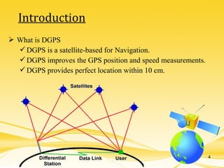
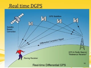
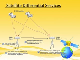
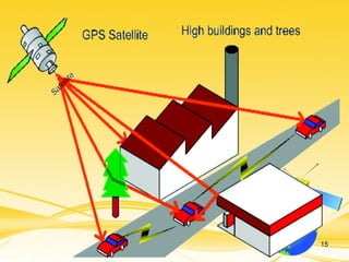
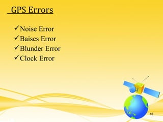
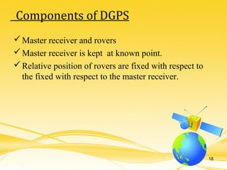
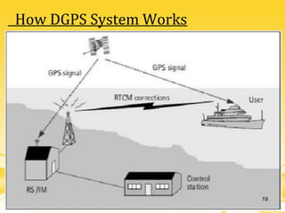
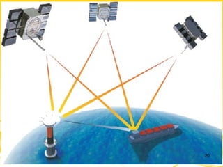
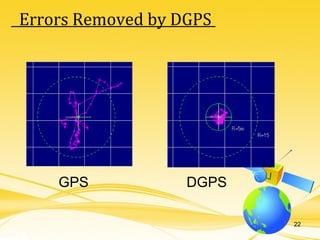
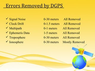
DIFFERENTIAL GLOBAL POSITIONING SYSTEM
SHREE MADHAV INSTITUTE OF COMPUTERSHREE MADHAV INSTITUTE OF COMPUTER
& INFORMATION TECHNOLOGY& INFORMATION TECHNOLOGY
PRESENTED BY : Maury Anand L. (1570)
1
AgendaAgenda
 Abstract
 Introduction
 History of DGPS
 How DGPS system works
 Error Possibilities in GPS
 Advantages
 Limitations
 Applications
 References
2
 Normal GPS (Global Positioning System) is not accurate
enough for the applications.
 For greater accuracy, a Differential GPS system will be
implemented. To do this, two GPS units are required. A base
station, with a known position, sends error correction data to a
mobile unit.
 The error correction data is sent wirelessly through a radio
link.
 The data can then be viewed on a laptop computer for
statistical analysis.
Abstract
3
 What is DGPS
DGPS is a satellite-based for Navigation.
DGPS improves the GPS position and speed measurements.
DGPS provides perfect location within 10 cm.
Introduction
4
The military requires very precise measurements across their
Battle scene.
5
 Global positioning system is developed and funded by US
Government and managed by department of defense.
 1973 - Decision to develop a satellite navigation system for
military.
 1974 -1979 conducted system tests by US air force and navy.
 2000 – Final deactivation of SA to give positional accuracy of
20M from 100M.
 2005 –Launching of the IIRM GPS satellite that supports the
new military M signal and the second civil signal L2C.
History of GPS
6
History of DGPS
 This technique was accuracy and integrity. This technique was
developed in the early 1980s, and it is developed in the early 1980s,
and it is widely used in various forms.
7
 DGPS is a method of improving the accuracy of your receiver
by adding a local reference station to augment the information
available from the satellites. It also improves the integrity of
the whole GPS system by identifying certain errors.
 Differential GPS uses one unit at a known location and a
rover.
 The stationary unit compares its calculated GPS location with
the actual location and computes the error.
 The rover data is adjusted for the error.
DGPS in Detail
8
1) Real-Time DGPS
2) Satellite Differential Services
Types of DGPS System
9
Real time DGPS
10
Satellite Differential Services
11
 The receiver is not synchronized with the atomic clock in the
satellite.
 The estimate of the position of the satellite.
 ”Multi path errors” : Ghost signals from ”Multi path errors” :
Ghost signals from reflected radio waves.
 Not free sight to many enough satellites.
 Noise in the receiver.
Error Possibilities in GPS
12
Error Value
Ionosphere 4.0 meters
Clock 2.1 meters
Ephemeris 2.1 meters
Troposphere 0.7 meters
Receiver 0.5 meters
Multipath 1.0 meter
Total 10.4 meters
Source Of Errors in GPS
13
14
15
Noise Error
Baises Error
Blunder Error
Clock Error
GPS Errors
16
Two Novatel® RT-20 Receivers
Operate at 1575.42 MHz
12 Channel Receivers
Two Free Wave® Radios
Operate at 928 MHz
20 mile line of sight range
Laptop, Computer
Equipment Used
17
Master receiver and rovers
Master receiver is kept at known point.
Relative position of rovers are fixed with respect to
the fixed with respect to the master receiver.
Components of DGPS
18
How DGPS System Works
19
20
21
GPS DGPS
Errors Removed by DGPS
22
23
Errors Removed by DGPS
 Signal Noise 0-30 meters All Removed
 Clock Drift 0-1.5 meters All Removed
 Multipath 0-1 meters All Removed
 Ephemeris Data 1-5 meters All Removed
 Troposphere 0-30 meters All Removed
 Ionosphere 0-30 meters Mostly Removed
 DGPS helps to know perfect location on the earth.
 Provide accurate data within a minute.
 GPS is quite accurate; however, using DGPS pushes its
accuracy even further.
 GPS/DGPS makes A/L guidance every precise as oppose to
ILS and MLS.
Advantages
24
 The coverage area to take advantage of DGPS is limited.
 To ensure greater coverage area more DGPS stations need to
be added.
 The position accuracy degrades as the separation between
DGPS and aircraft GPS-Rx increases.
25
Limitations
 Air Navigation
By using it a pilot can receive constant information about
where the plane is in 3 dimensions.
 Weather forecasting
 Where atmospheric information can be gained from its effects on
the satellite signals.
 Train Control
 For such things as avoiding collisions and routing.
 Marine, Ship Navigation
 By using it a ship can receive constant information about current
location and parking location on port.
26
Applications
Website :
www.en.wikipedia.org
www.dgll.nic.in
Location :
Hazira DGPS Station
27
References

Dgps seminar

  • 1.
    DIFFERENTIAL GLOBAL POSITIONINGSYSTEM SHREE MADHAV INSTITUTE OF COMPUTERSHREE MADHAV INSTITUTE OF COMPUTER & INFORMATION TECHNOLOGY& INFORMATION TECHNOLOGY PRESENTED BY : Maury Anand L. (1570) 1
  • 2.
    AgendaAgenda  Abstract  Introduction History of DGPS  How DGPS system works  Error Possibilities in GPS  Advantages  Limitations  Applications  References 2
  • 3.
     Normal GPS(Global Positioning System) is not accurate enough for the applications.  For greater accuracy, a Differential GPS system will be implemented. To do this, two GPS units are required. A base station, with a known position, sends error correction data to a mobile unit.  The error correction data is sent wirelessly through a radio link.  The data can then be viewed on a laptop computer for statistical analysis. Abstract 3
  • 4.
     What isDGPS DGPS is a satellite-based for Navigation. DGPS improves the GPS position and speed measurements. DGPS provides perfect location within 10 cm. Introduction 4
  • 5.
    The military requiresvery precise measurements across their Battle scene. 5
  • 6.
     Global positioningsystem is developed and funded by US Government and managed by department of defense.  1973 - Decision to develop a satellite navigation system for military.  1974 -1979 conducted system tests by US air force and navy.  2000 – Final deactivation of SA to give positional accuracy of 20M from 100M.  2005 –Launching of the IIRM GPS satellite that supports the new military M signal and the second civil signal L2C. History of GPS 6
  • 7.
    History of DGPS This technique was accuracy and integrity. This technique was developed in the early 1980s, and it is developed in the early 1980s, and it is widely used in various forms. 7
  • 8.
     DGPS isa method of improving the accuracy of your receiver by adding a local reference station to augment the information available from the satellites. It also improves the integrity of the whole GPS system by identifying certain errors.  Differential GPS uses one unit at a known location and a rover.  The stationary unit compares its calculated GPS location with the actual location and computes the error.  The rover data is adjusted for the error. DGPS in Detail 8
  • 9.
    1) Real-Time DGPS 2)Satellite Differential Services Types of DGPS System 9
  • 10.
  • 11.
  • 12.
     The receiveris not synchronized with the atomic clock in the satellite.  The estimate of the position of the satellite.  ”Multi path errors” : Ghost signals from ”Multi path errors” : Ghost signals from reflected radio waves.  Not free sight to many enough satellites.  Noise in the receiver. Error Possibilities in GPS 12
  • 13.
    Error Value Ionosphere 4.0meters Clock 2.1 meters Ephemeris 2.1 meters Troposphere 0.7 meters Receiver 0.5 meters Multipath 1.0 meter Total 10.4 meters Source Of Errors in GPS 13
  • 14.
  • 15.
  • 16.
    Noise Error Baises Error BlunderError Clock Error GPS Errors 16
  • 17.
    Two Novatel® RT-20Receivers Operate at 1575.42 MHz 12 Channel Receivers Two Free Wave® Radios Operate at 928 MHz 20 mile line of sight range Laptop, Computer Equipment Used 17
  • 18.
    Master receiver androvers Master receiver is kept at known point. Relative position of rovers are fixed with respect to the fixed with respect to the master receiver. Components of DGPS 18
  • 19.
  • 20.
  • 21.
  • 22.
  • 23.
    23 Errors Removed byDGPS  Signal Noise 0-30 meters All Removed  Clock Drift 0-1.5 meters All Removed  Multipath 0-1 meters All Removed  Ephemeris Data 1-5 meters All Removed  Troposphere 0-30 meters All Removed  Ionosphere 0-30 meters Mostly Removed
  • 24.
     DGPS helpsto know perfect location on the earth.  Provide accurate data within a minute.  GPS is quite accurate; however, using DGPS pushes its accuracy even further.  GPS/DGPS makes A/L guidance every precise as oppose to ILS and MLS. Advantages 24
  • 25.
     The coveragearea to take advantage of DGPS is limited.  To ensure greater coverage area more DGPS stations need to be added.  The position accuracy degrades as the separation between DGPS and aircraft GPS-Rx increases. 25 Limitations
  • 26.
     Air Navigation Byusing it a pilot can receive constant information about where the plane is in 3 dimensions.  Weather forecasting  Where atmospheric information can be gained from its effects on the satellite signals.  Train Control  For such things as avoiding collisions and routing.  Marine, Ship Navigation  By using it a ship can receive constant information about current location and parking location on port. 26 Applications
  • 27.