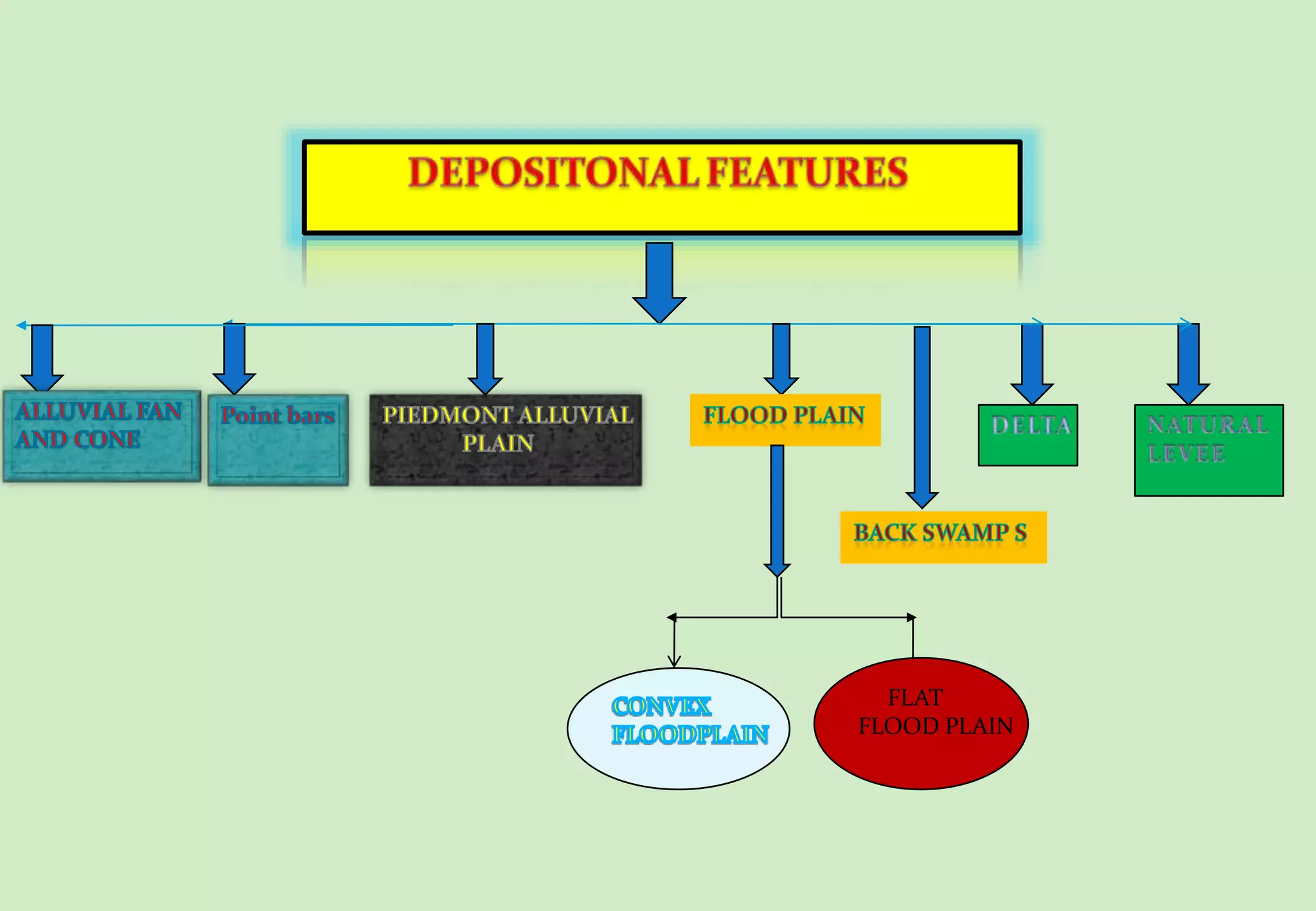
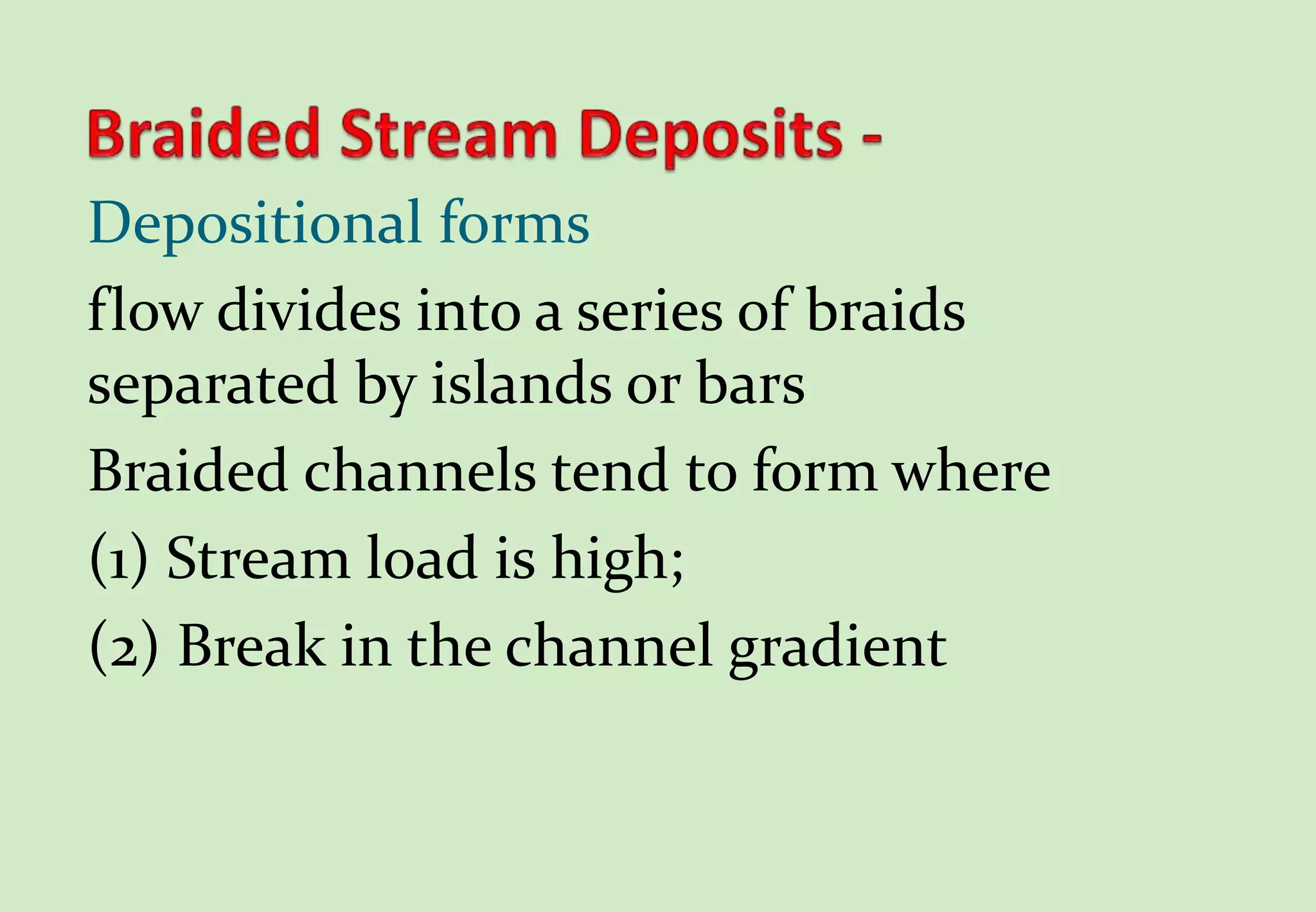
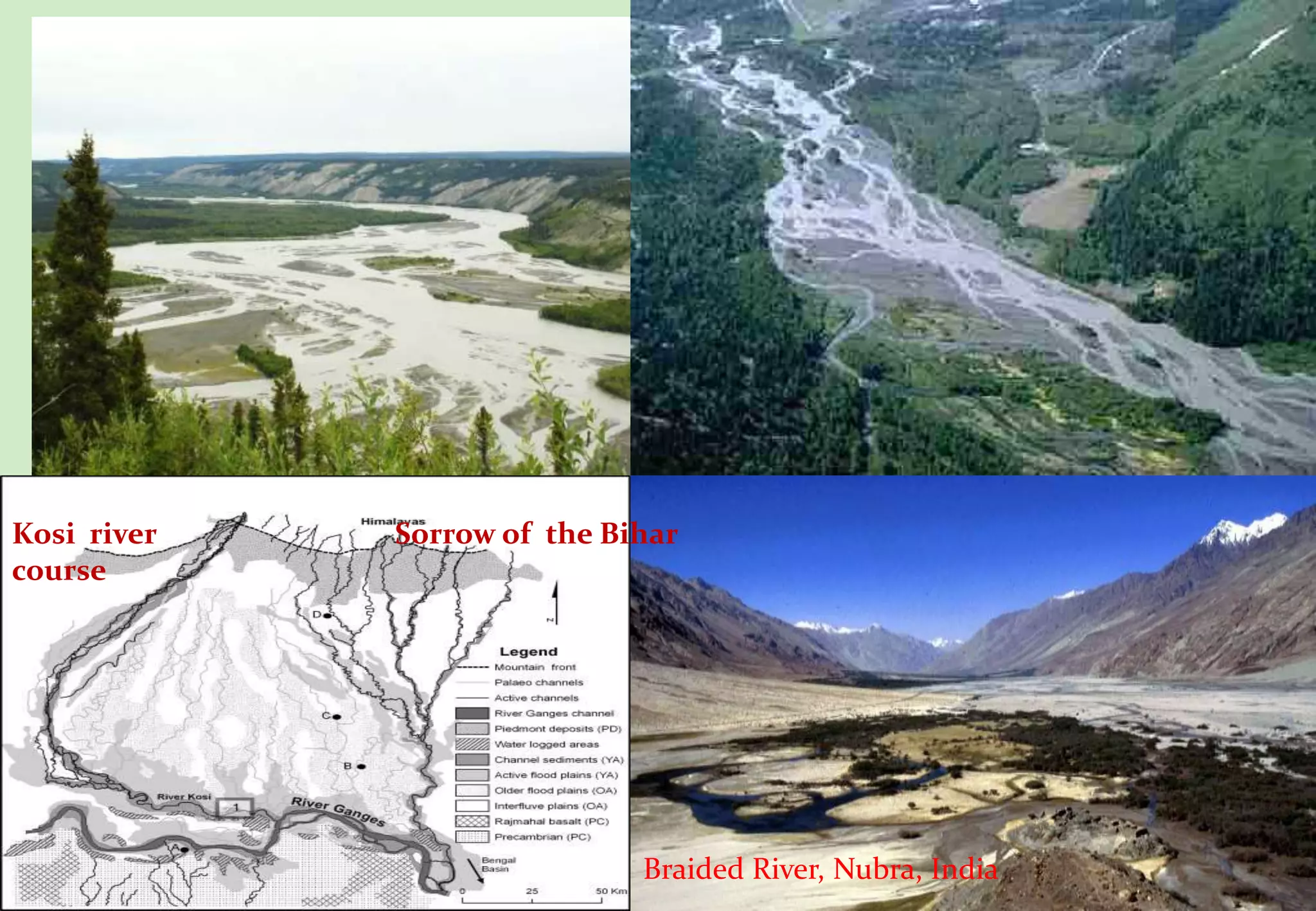
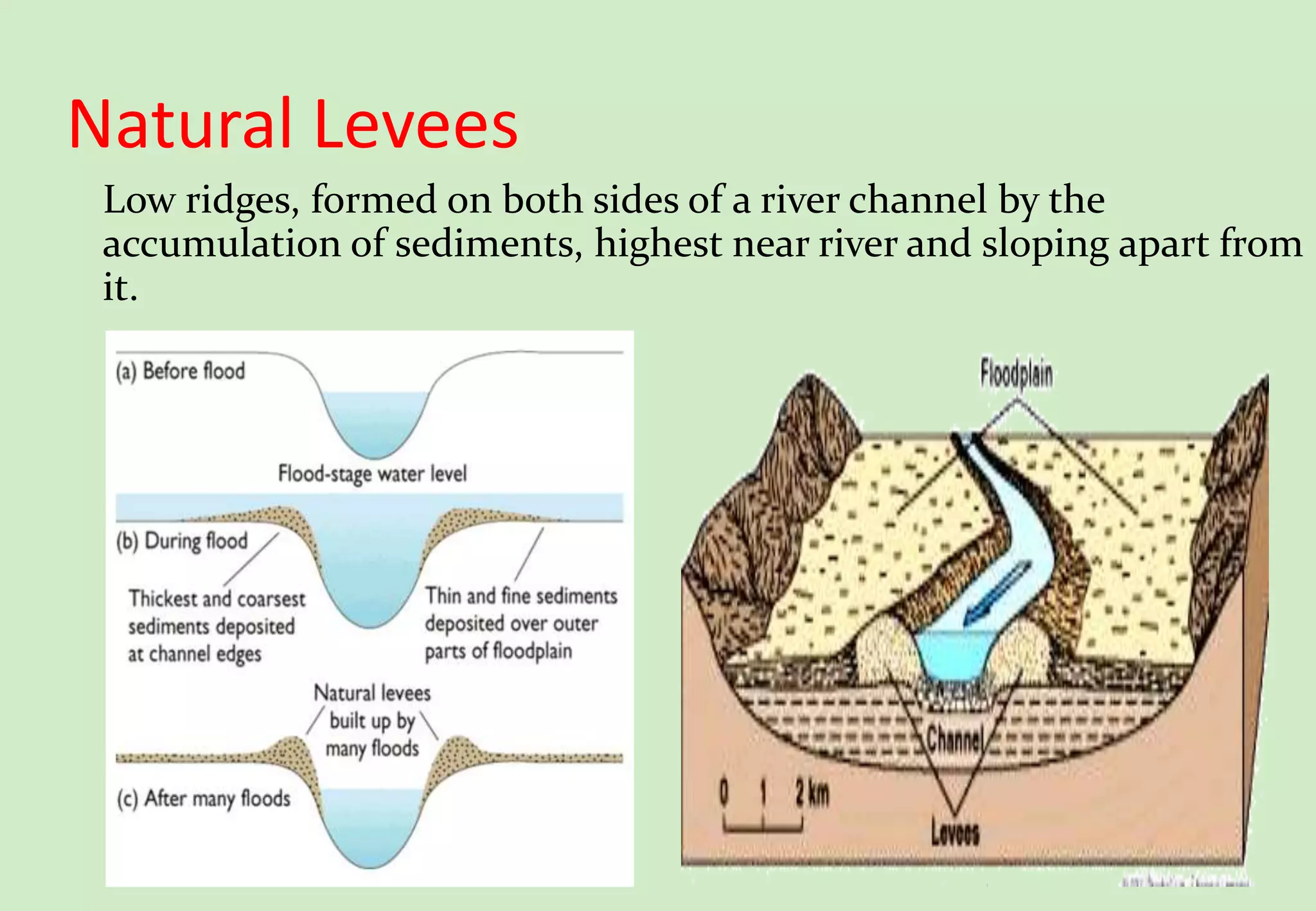
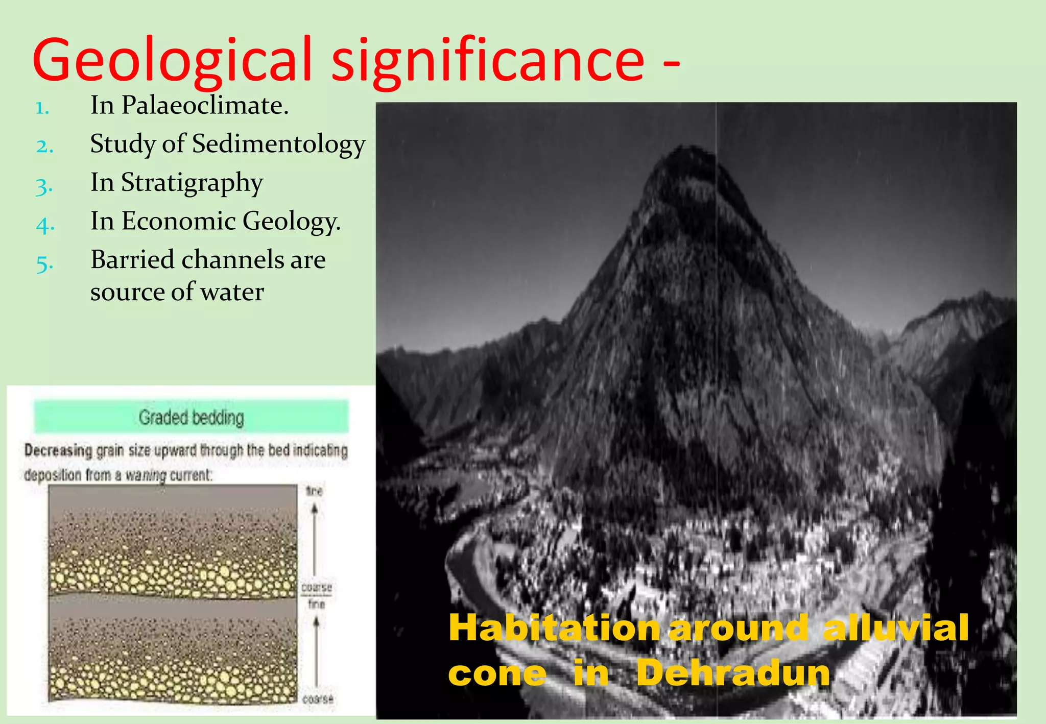
DEPARTMENT OF APPLIED GEOLOGY
DR. HARISINGH GOUR VISHWAVIDAYALA, SAGAR(M.P.)
A SEMINAR
ON
Fluvial Depositional Landforms
Under the Guidance of:- Presented By:-
Prof. P.K. Kathal Varun Shastri
Y18251028
CONTENTS
 Introduction
 Reasons of deposition
 Classification of alluvial
deposits.
 Alluvial fans and cones.
 Braided stream deposits.
 Meandering belt
deposits.
 Point bar deposits.
 Back swamp deposits.
 Flood plain deposits.
 Natural Levee.
 River delta.
 Geological significance.
 conclusion
INTRODUCTION
 Stream deposition - Accumulation /deposition of loose transported material by
stream in a basin.
 Fluvial Depositional Landforms – landforms either carved out due to
erosion or built up due to deposition by running water.
 They are constructional landforms.
 CAPACITY of the stream is the total potential weight of sediment load which a stream
can carry
LOAD CARRIED BY RIVER
 A river carries load in FOUR
forms
1) SOLUTION
2) SUSPENSION
3) SALTATION
4) TRACTION
Reasons of Deposition
 Break in slope.
 Obstruction in the channel.
 Spreading of water over large area.
 Decrease in volume and discharge of water.
 Contact with quiet water.
 Acceleration rate of erosion in catchment area.
 Supply of glacio-fluvial material.
 Supply of additional sediments by tributaries.
 Gradual increase load of sediments by rill and gully erosion.
FLAT
FLOOD PLAIN
Alluvial Cones: slope angle(150) cone
shaped, porous sediments
Alluvial cone
Peidmont Alluvial plain
 Where closely spaced stream discharge
from a mountain region across the
piedmont.
 Their deposit coalesce at the base of
the mountain to form a peidmont
alluvial plain, e.g. Indo-Gangetic plain
on the southern peidmont of Himalayas
 The Canturbury plains of NZ
mountain
s
Coalesce of
aluvial cone
Base of the mountain
Depositional forms
flow divides into a series of braids
separated by islands or bars
Braided channels tend to form where
(1) Stream load is high;
(2) Break in the channel gradient
Braided River, Nubra, India
Kosi river
course
Sorrow of the Bihar
Bends of longitudinal course of the rivers
The bend of meander have two types of
slope sides.
1. Cliff slope side - concave slope ,
channel strikes directly with severe
erosion resulting in to formation of
vertical cliff.
2. Slip-off slope side - convex slope ,
deposition mostly of sand and gravel
but sometime alluvium is also
deposited, gentle slope.
Abandoned meanders become Ox-bow
lakes, filled by clays
Meandering Belt
Deposits -
Point
bar
Back
swamp
Natural
levee
Point bars
Found on convex side
of meander, grow by
individual increment,
surrounded by water.
Point bar
Abandoned channel filling
Filling of former
channels during flood.
Point bar
Abandoned channel
filling
Deposits of silt and clay
laid down in the flood
basin back of natural
levees as water logged.
Low lying deposits during
flooding in late mature stage,
formed due to decrease in water
volume after flood.
Flat flood
plain
Natural Levees
Low ridges, formed on both sides of a river channel by the
accumulation of sediments, highest near river and sloping apart from
it.
Delta
 Occur where stream hits
slow water
 Suspended load is dropped
 Deposits build out into lake
or sheltered sea, extending
the length of the river
 Consists of three types of
beds
 Topset beds -
horizontal, surface
delta
 Foreset beds - delta
slope
 Bottomset beds –
horizontal, bottom
sea
Delta
 Abandoned delta lobes are
sediment-starved.
 Sediments deposited before
avulsion slowly subside.
 Compaction and
dewatering.
 Decay of organic matter.
 Lack of sediment
nourishment.
 Eventually, abandoned
delta lobes are submerged.
Geological significance -1. In Palaeoclimate.
2. Study of Sedimentology
3. In Stratigraphy
4. In Economic Geology.
5. Barried channels are
source of water
Habitation around alluvial
cone in Dehradun
Conclusion
 Fluvial depositional landforms are constructional or
positive landforms cover smaller area on earth surface
than erosional features.
• Give no information about recent diastrophic history
as erosional landforms .
• These landforms low relief than erosional landforms.
• Used for cultivation
References
 Thornbury william D., Principle of geomorphology
second edition , CBS publishers and distributors.
 Sam boggs jr. (1996), principle of stratigraphy and
sedimentology 2nd edition, apperentice hall publication.
 Siddharta k., The earth dynamic surface. A text book on
geomorphology, kisalaya publications pvt. Ltd.
 Dr. Savindra singh, geomorphology, prayag pustak bhawan.
THANK YOU

Fluvial depositional landform geomorphology

  • 1.
    DEPARTMENT OF APPLIEDGEOLOGY DR. HARISINGH GOUR VISHWAVIDAYALA, SAGAR(M.P.) A SEMINAR ON Fluvial Depositional Landforms Under the Guidance of:- Presented By:- Prof. P.K. Kathal Varun Shastri Y18251028
  • 2.
    CONTENTS  Introduction  Reasonsof deposition  Classification of alluvial deposits.  Alluvial fans and cones.  Braided stream deposits.  Meandering belt deposits.  Point bar deposits.  Back swamp deposits.  Flood plain deposits.  Natural Levee.  River delta.  Geological significance.  conclusion
  • 3.
    INTRODUCTION  Stream deposition- Accumulation /deposition of loose transported material by stream in a basin.  Fluvial Depositional Landforms – landforms either carved out due to erosion or built up due to deposition by running water.  They are constructional landforms.  CAPACITY of the stream is the total potential weight of sediment load which a stream can carry LOAD CARRIED BY RIVER  A river carries load in FOUR forms 1) SOLUTION 2) SUSPENSION 3) SALTATION 4) TRACTION
  • 4.
    Reasons of Deposition Break in slope.  Obstruction in the channel.  Spreading of water over large area.  Decrease in volume and discharge of water.  Contact with quiet water.  Acceleration rate of erosion in catchment area.  Supply of glacio-fluvial material.  Supply of additional sediments by tributaries.  Gradual increase load of sediments by rill and gully erosion.
  • 5.
  • 6.
    Alluvial Cones: slopeangle(150) cone shaped, porous sediments Alluvial cone
  • 8.
    Peidmont Alluvial plain Where closely spaced stream discharge from a mountain region across the piedmont.  Their deposit coalesce at the base of the mountain to form a peidmont alluvial plain, e.g. Indo-Gangetic plain on the southern peidmont of Himalayas  The Canturbury plains of NZ mountain s Coalesce of aluvial cone Base of the mountain
  • 9.
    Depositional forms flow dividesinto a series of braids separated by islands or bars Braided channels tend to form where (1) Stream load is high; (2) Break in the channel gradient
  • 10.
    Braided River, Nubra,India Kosi river course Sorrow of the Bihar
  • 11.
    Bends of longitudinalcourse of the rivers The bend of meander have two types of slope sides. 1. Cliff slope side - concave slope , channel strikes directly with severe erosion resulting in to formation of vertical cliff. 2. Slip-off slope side - convex slope , deposition mostly of sand and gravel but sometime alluvium is also deposited, gentle slope. Abandoned meanders become Ox-bow lakes, filled by clays
  • 12.
  • 13.
    Point bars Found onconvex side of meander, grow by individual increment, surrounded by water. Point bar Abandoned channel filling Filling of former channels during flood. Point bar Abandoned channel filling
  • 14.
    Deposits of siltand clay laid down in the flood basin back of natural levees as water logged.
  • 15.
    Low lying depositsduring flooding in late mature stage, formed due to decrease in water volume after flood. Flat flood plain
  • 16.
    Natural Levees Low ridges,formed on both sides of a river channel by the accumulation of sediments, highest near river and sloping apart from it.
  • 17.
    Delta  Occur wherestream hits slow water  Suspended load is dropped  Deposits build out into lake or sheltered sea, extending the length of the river  Consists of three types of beds  Topset beds - horizontal, surface delta  Foreset beds - delta slope  Bottomset beds – horizontal, bottom sea
  • 18.
    Delta  Abandoned deltalobes are sediment-starved.  Sediments deposited before avulsion slowly subside.  Compaction and dewatering.  Decay of organic matter.  Lack of sediment nourishment.  Eventually, abandoned delta lobes are submerged.
  • 19.
    Geological significance -1.In Palaeoclimate. 2. Study of Sedimentology 3. In Stratigraphy 4. In Economic Geology. 5. Barried channels are source of water Habitation around alluvial cone in Dehradun
  • 20.
    Conclusion  Fluvial depositionallandforms are constructional or positive landforms cover smaller area on earth surface than erosional features. • Give no information about recent diastrophic history as erosional landforms . • These landforms low relief than erosional landforms. • Used for cultivation
  • 21.
    References  Thornbury williamD., Principle of geomorphology second edition , CBS publishers and distributors.  Sam boggs jr. (1996), principle of stratigraphy and sedimentology 2nd edition, apperentice hall publication.  Siddharta k., The earth dynamic surface. A text book on geomorphology, kisalaya publications pvt. Ltd.  Dr. Savindra singh, geomorphology, prayag pustak bhawan.
  • 22.