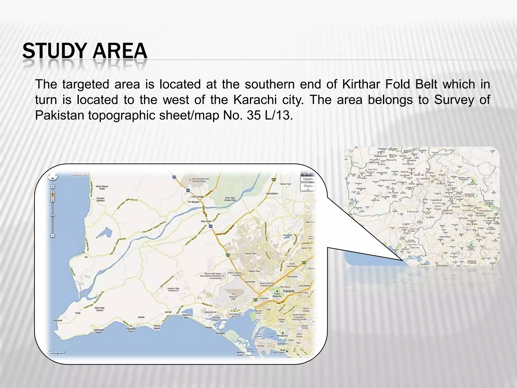
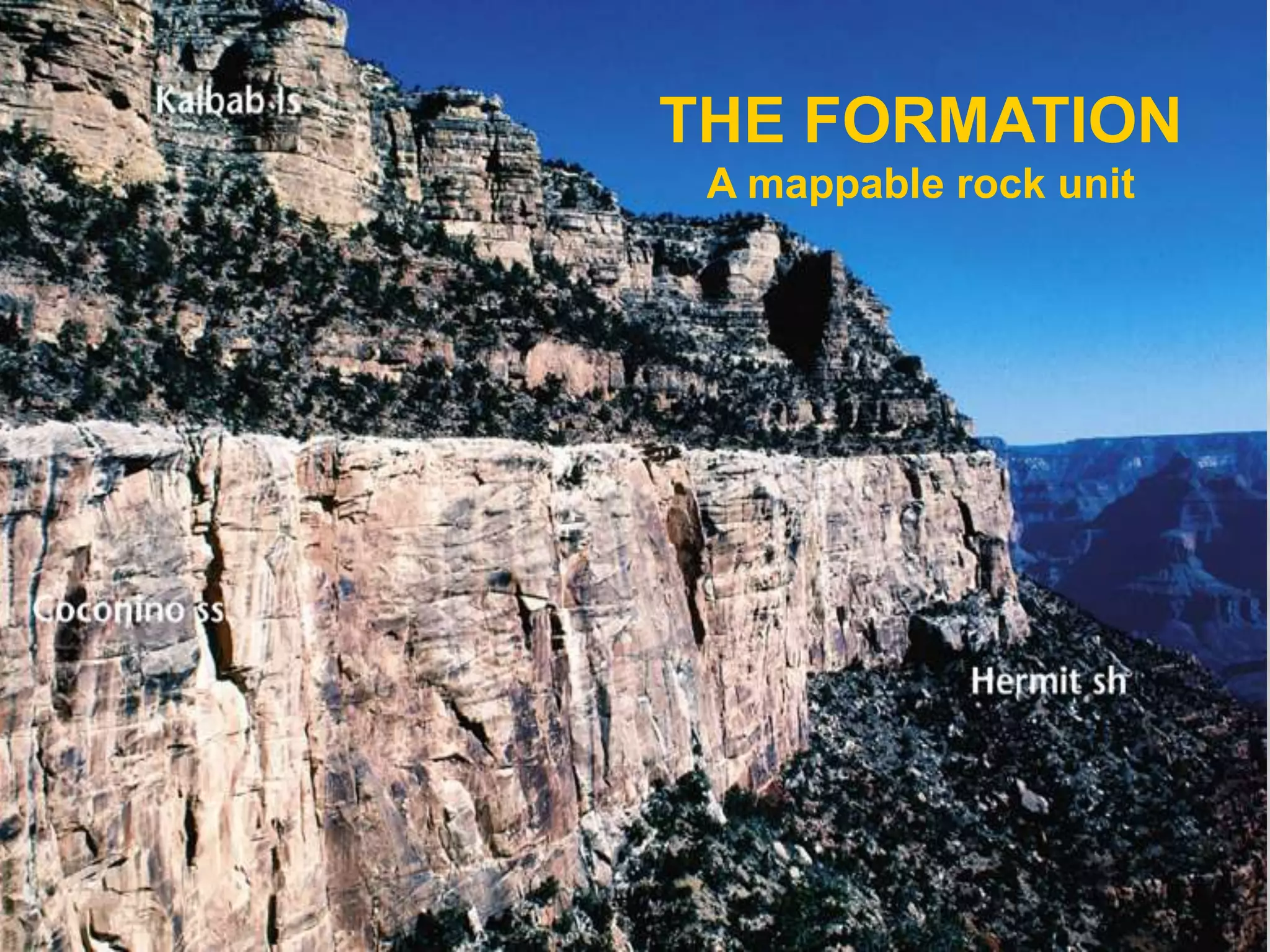
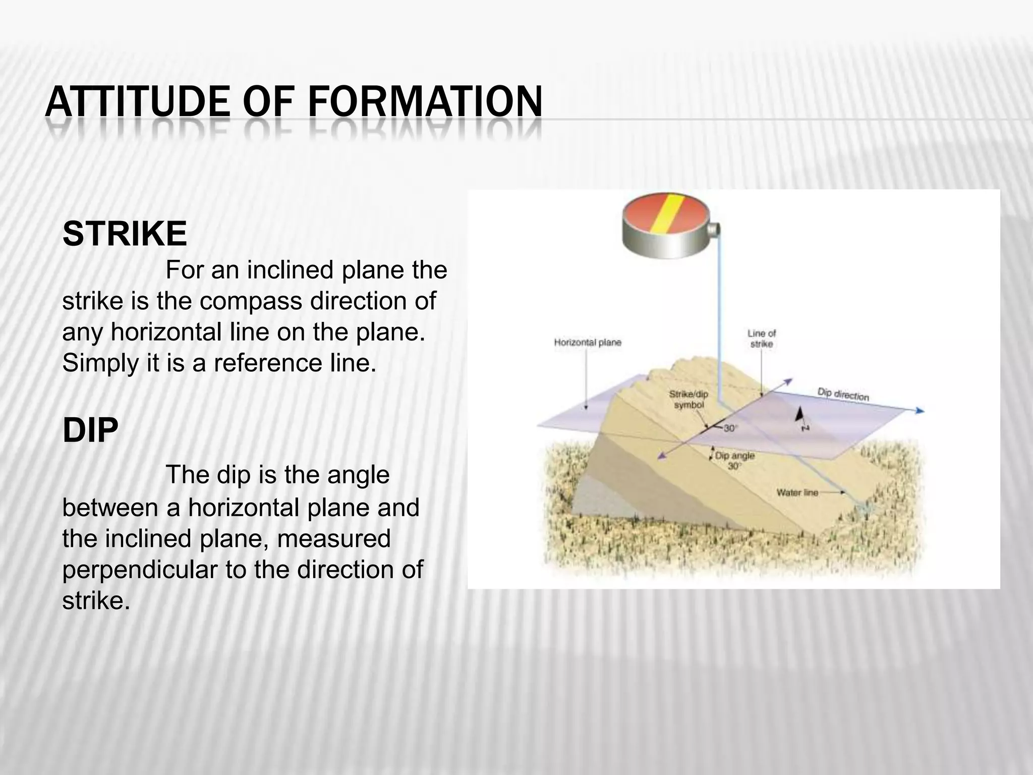
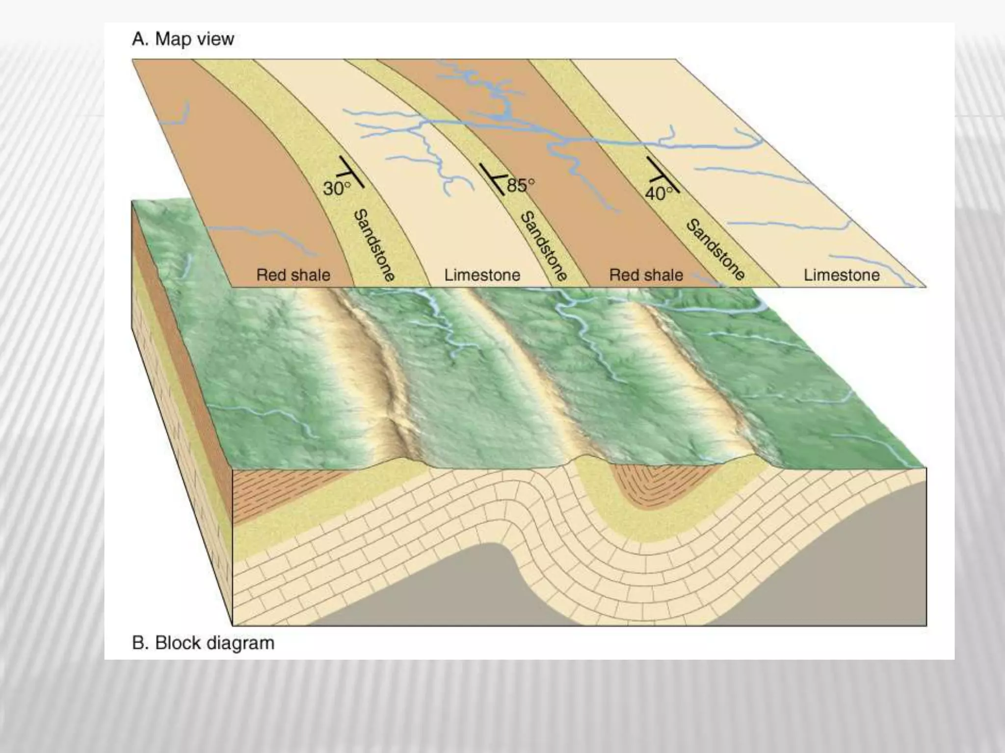
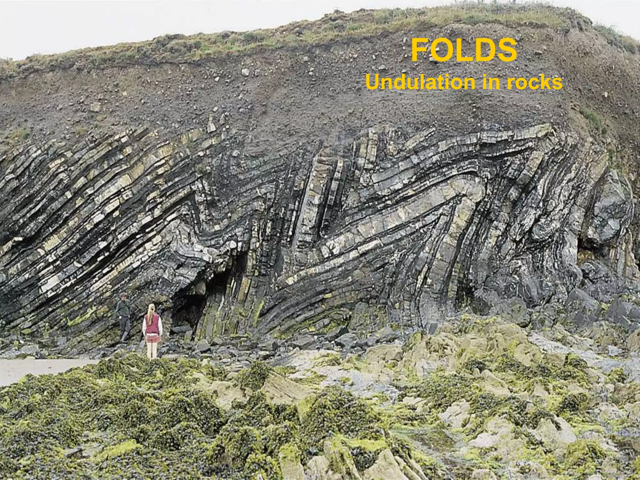
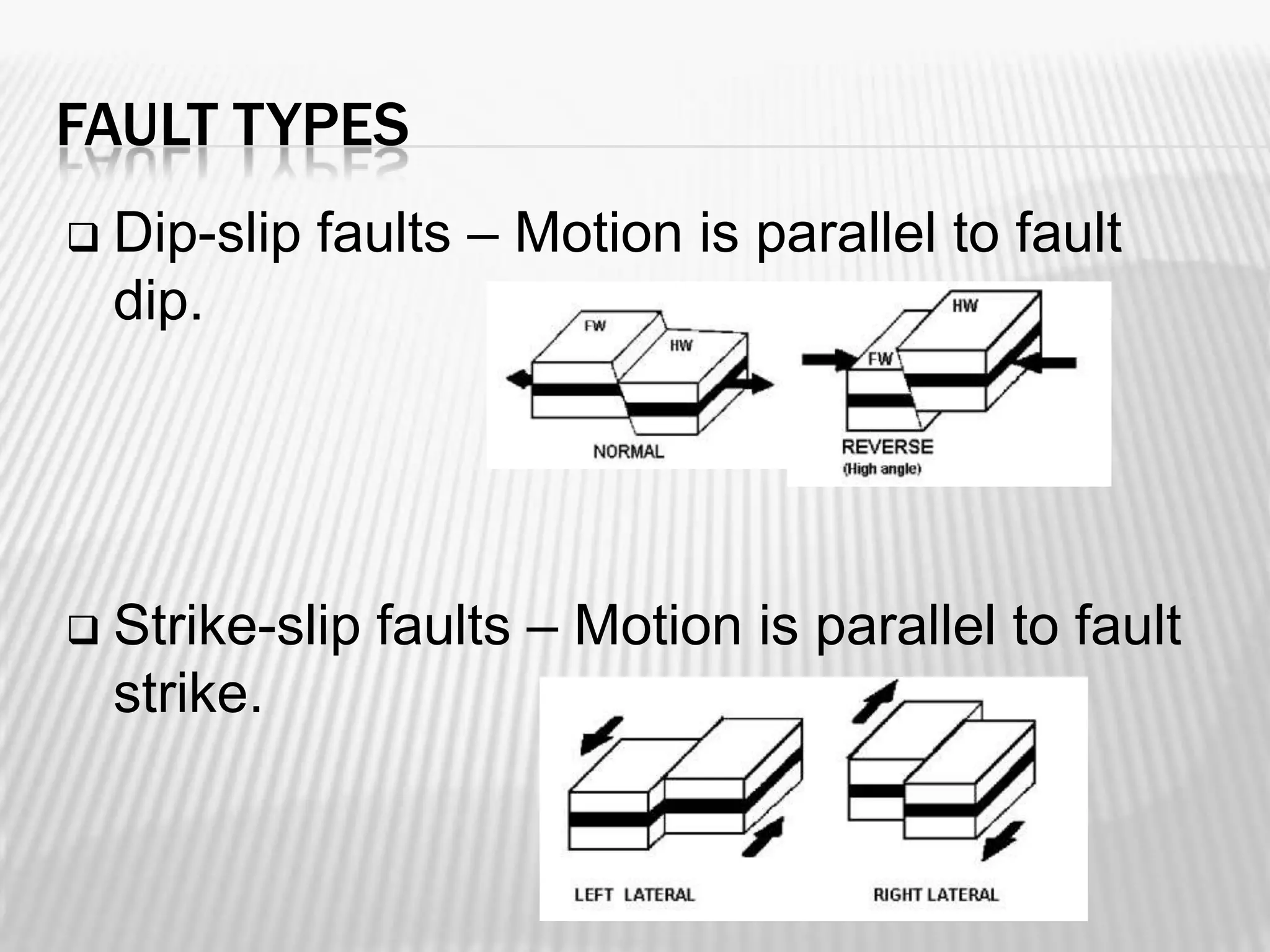
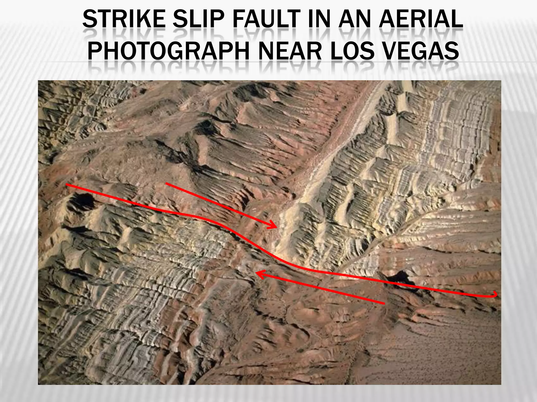
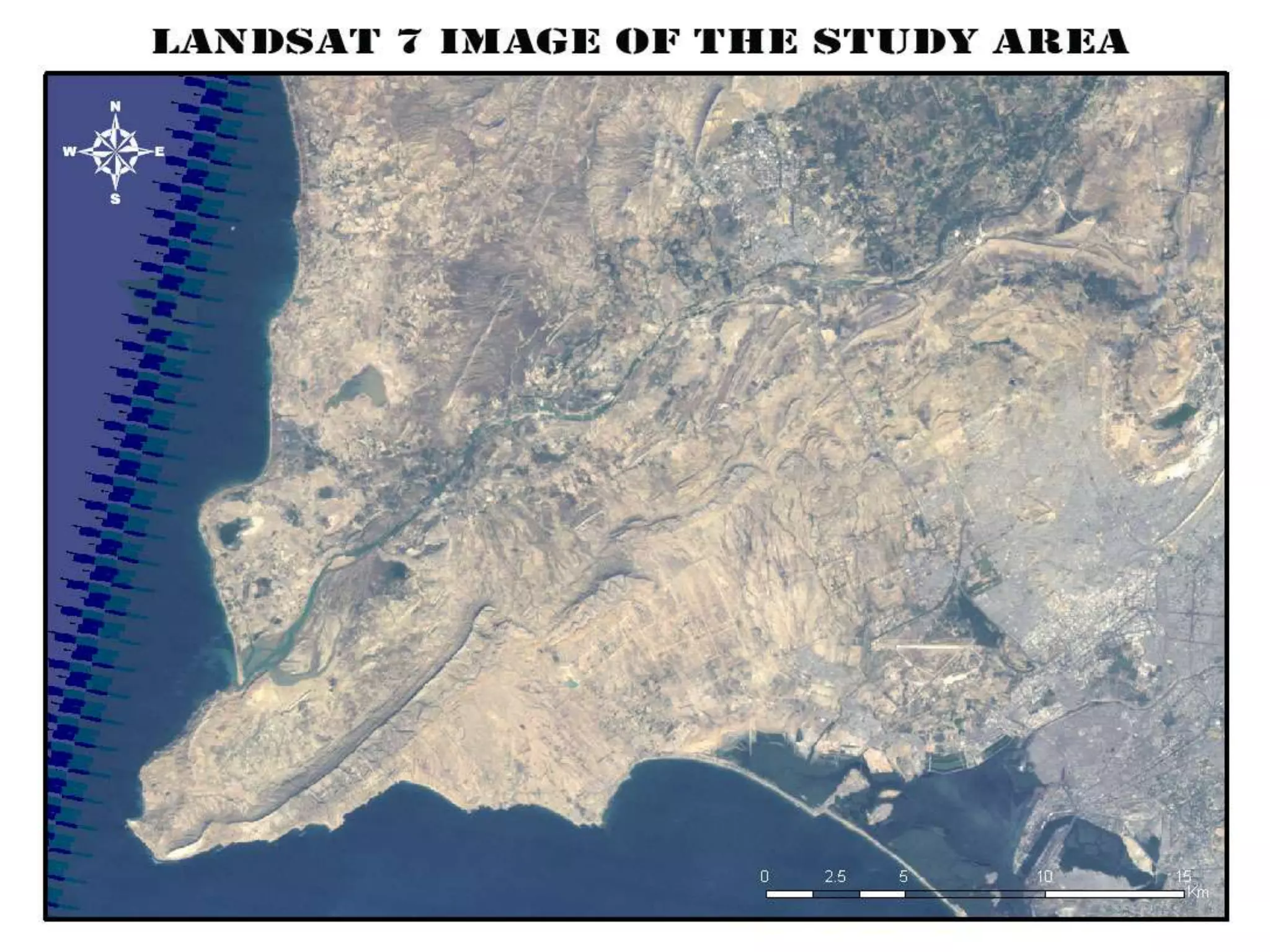
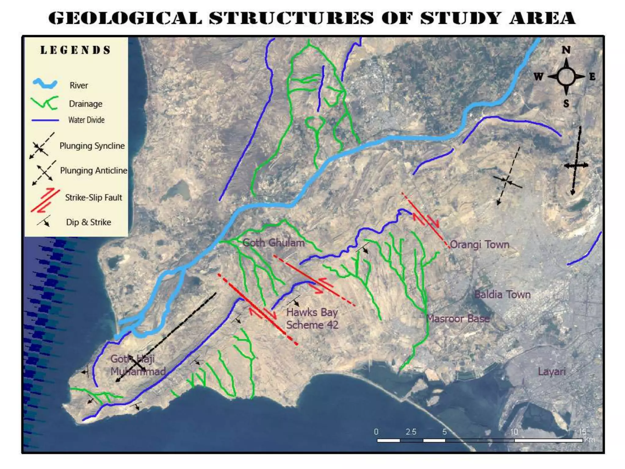
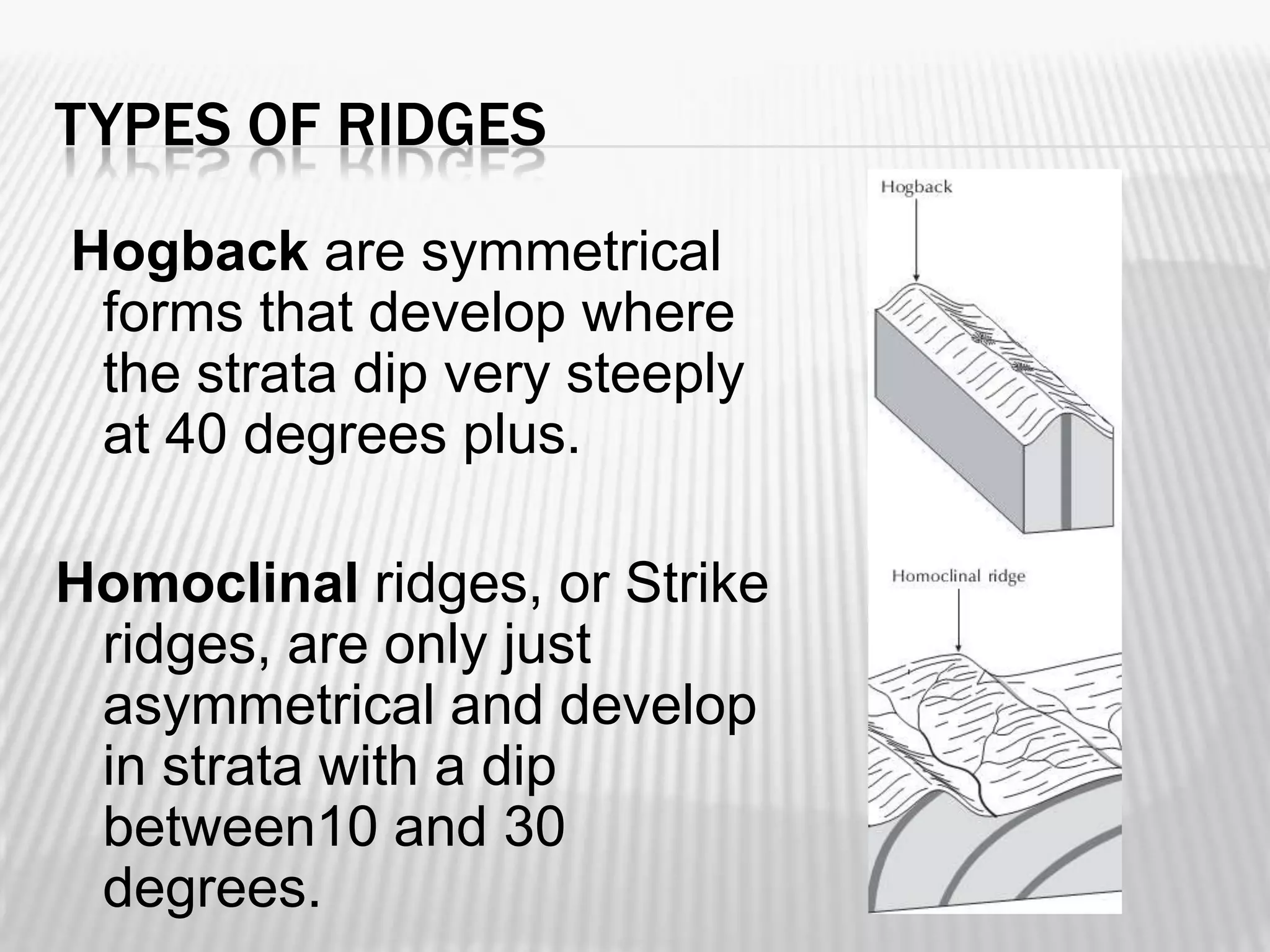
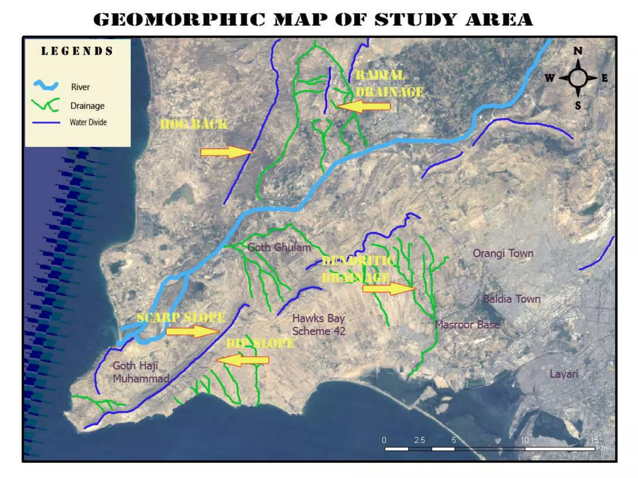
SlideShare a Scribd company logo
1 of 27
GEOMORPHIC AND STRUCTURAL
STUDY OF SONA PASS AND LAL
BAKHAR AREA NEAR HUB RIVER

Hafiz Uzair Ahmed Khan
SEQUENCE


Objectives of the study



Brief description of various geological features
marked on the image



Methodology



Geological and geomorphic map of the study
area



Result and conclusion
OBJECTIVE


Identify the following structures on satellite
image:






Normal, reverse, and lateral faults
Synclines and anticlines, both non-plunging and
plunging.
State the direction of plunge where relevant.
The axis of a fold.



To mark major Geomorphological structures.



Use of Landsat 7 imagery for above studies.
STUDY AREA
The targeted area is located at the southern end of Kirthar Fold Belt which in
turn is located to the west of the Karachi city. The area belongs to Survey of
Pakistan topographic sheet/map No. 35 L/13.
THE FORMATION
A mappable rock unit
ATTITUDE OF FORMATION
STRIKE
For an inclined plane the
strike is the compass direction of
any horizontal line on the plane.
Simply it is a reference line.

DIP
The dip is the angle
between a horizontal plane and
the inclined plane, measured
perpendicular to the direction of
strike.
FOLDS
Undulation in rocks
FOLDS


Rocks are bent by crustal deformation into a
series of wave-like undulations called folds.



Most folds result from compressional
stresses which shorten and thicken the
crust.
COMMON TYPES OF FOLDS




Anticline – Upfolded or arched rock layers.
Syncline – Downfolds or rock troughs. (Think “sink”)
Depending on their orientation, anticlines and
synclines can be described as





Symmetrical
Asymmetrical
Overturned fold
Plunging
Anticline
Syncline
PLUNGING FOLDS

An anticlinal axis that is tilted is
said to pitch or plunge. The
angle of plunge is the angle
between the anticlinal axis and
a horizontal plane. Plunging
anticlines can be thought of as
elongated domes. Synclinal
axes may also plunge.
FAULTS
Fracture In Rocks
FAULTS


Breaks in rock that exhibit offset.



Exist at a variety of scales.



Sudden movements along faults are the cause of
most earthquakes.



Classified by movement…
 Horizontal
 Vertical
 Oblique
FAULT TYPES


Dip-slip faults – Motion is parallel to fault
dip.



Strike-slip faults – Motion is parallel to fault
strike.
STRIKE SLIP FAULT IN AN AERIAL
PHOTOGRAPH NEAR LOS VEGAS
IMPORTANCE OF GEOLOGICAL STRUCTURES


Economic Geology









Petroleum Geology
Mining Geology

Faults are permeable zones for hydrothermal fluids
Veins of minerals occupy faults and fractures
It effect the stability of human engineered structures
Earthquakes: by combination of Geology and
Geomorphology
Steep slopes are potential collapse and Landslide
hazards
METHODOLOGY


Geologic Structures are visually interpreted after
studying the tectonics of the area.



Strike slip faults are evident due to the displacement
of ridges.



Folds are marked with the help of attitude of
formations.



Different types of ridges are marked on the basis of
slope angle.



All the observable Geologic and Geomorphic features
are marked on the satellite image.
SCARP AND DIP SLOPE
In geology, the two slopes
comprise an escarpment


The scarp is the steep slope
which cuts across the
bedding planes of the
sedimentary rock.



The dip is the gentle slope
which follows the direction of
the strata.

Such features are common
when sedimentary rocks are
uplifted, folded, or eroded.
DRAINAGE TYPES AND GEOLOGICAL SIGNIFICANCE
TYPE

DESCRIPTION

GEOLOGICAL SIGNIFICANCE

Irregular branching of Homogenous material and
DENDRITIC streams, haphazardly, crystalline rocks: horizontal beds;
resembling a tree.
gentle regional slope.

RADIAL

Stream originating
from a central point of
region.

Volcanoes, domes, igneous
intrusions; residual erosion
features.
TYPES OF RIDGES
Hogback are symmetrical
forms that develop where
the strata dip very steeply
at 40 degrees plus.

Homoclinal ridges, or Strike
ridges, are only just
asymmetrical and develop
in strata with a dip
between10 and 30
degrees.
RESULT AND CONCLUSION


Landsat data revealed to be capable of
depicting large scale geological and
geomorphic structure.



Small scale geologic features e.g. beds, --------are not visible on the image.



Topographic data is essential for detail
geomorphic studies.

More Related Content

What's hot

Geophysical prospecting
Geophysical prospecting Geophysical prospecting
Geophysical prospecting
Spondan Bora
 
Aerial photography abraham thomas
Aerial photography abraham thomasAerial photography abraham thomas
Aerial photography abraham thomas
Sumant Diwakar
 
Petroleum introduction
Petroleum introductionPetroleum introduction
Petroleum introduction
Andrew Zolnai
 
Geomorphology applications
Geomorphology applicationsGeomorphology applications
Geomorphology applications
vyshalik
 

What's hot (20)

Geophysical prospecting
Geophysical prospecting Geophysical prospecting
Geophysical prospecting
 
Geological mapping
Geological mappingGeological mapping
Geological mapping
 
Anomolies in drainage sediments
Anomolies in drainage  sedimentsAnomolies in drainage  sediments
Anomolies in drainage sediments
 
Stages of exploration
Stages of explorationStages of exploration
Stages of exploration
 
Geological criteria for ore prospecting
Geological criteria for ore prospectingGeological criteria for ore prospecting
Geological criteria for ore prospecting
 
Scale of photograph (Aerial Photogrammetry)
Scale of photograph (Aerial Photogrammetry)Scale of photograph (Aerial Photogrammetry)
Scale of photograph (Aerial Photogrammetry)
 
ELECTRICAL METHODS OF GEOPHYSICAL EXPLORATION OF MINERAL DEPOSITS.pptx
ELECTRICAL METHODS OF GEOPHYSICAL EXPLORATION OF MINERAL DEPOSITS.pptxELECTRICAL METHODS OF GEOPHYSICAL EXPLORATION OF MINERAL DEPOSITS.pptx
ELECTRICAL METHODS OF GEOPHYSICAL EXPLORATION OF MINERAL DEPOSITS.pptx
 
Aerial photography abraham thomas
Aerial photography abraham thomasAerial photography abraham thomas
Aerial photography abraham thomas
 
Structural and Geological Study of a part of the Chitradurga Schist Belt
Structural and Geological Study of a part of the Chitradurga Schist BeltStructural and Geological Study of a part of the Chitradurga Schist Belt
Structural and Geological Study of a part of the Chitradurga Schist Belt
 
Petroleum introduction
Petroleum introductionPetroleum introduction
Petroleum introduction
 
Aerial photography.pptx
Aerial photography.pptxAerial photography.pptx
Aerial photography.pptx
 
Geomorphology applications
Geomorphology applicationsGeomorphology applications
Geomorphology applications
 
Biochemical anomolies
Biochemical anomolies Biochemical anomolies
Biochemical anomolies
 
Morphometric Analysis of Drainage Basin.pptx
Morphometric Analysis of Drainage Basin.pptxMorphometric Analysis of Drainage Basin.pptx
Morphometric Analysis of Drainage Basin.pptx
 
Geochemical methods in mineral exploration
Geochemical  methods  in  mineral  explorationGeochemical  methods  in  mineral  exploration
Geochemical methods in mineral exploration
 
Stratigraphic Code
Stratigraphic CodeStratigraphic Code
Stratigraphic Code
 
Geothermometry in economic geology
 Geothermometry in economic geology Geothermometry in economic geology
Geothermometry in economic geology
 
Mineralization controlled by Tectonics & structures.ppt
Mineralization controlled by Tectonics & structures.pptMineralization controlled by Tectonics & structures.ppt
Mineralization controlled by Tectonics & structures.ppt
 
Geophysical survey
Geophysical surveyGeophysical survey
Geophysical survey
 
Geological criteria in exploration
Geological criteria in explorationGeological criteria in exploration
Geological criteria in exploration
 

Viewers also liked

Remote Sensing And GIS Application In Mineral , Oil , Ground Water MappingMin...
Remote Sensing And GIS Application In Mineral , Oil , Ground Water MappingMin...Remote Sensing And GIS Application In Mineral , Oil , Ground Water MappingMin...
Remote Sensing And GIS Application In Mineral , Oil , Ground Water MappingMin...
Swetha A
 
HYPERSPECTRAL RS IN MINERAL MAPPING
HYPERSPECTRAL RS IN MINERAL MAPPINGHYPERSPECTRAL RS IN MINERAL MAPPING
HYPERSPECTRAL RS IN MINERAL MAPPING
Abhiram Kanigolla
 

Viewers also liked (20)

Application of Basic Remote Sensing in Geology
Application of Basic Remote Sensing in GeologyApplication of Basic Remote Sensing in Geology
Application of Basic Remote Sensing in Geology
 
Remote Sensing And GIS Application In Mineral , Oil , Ground Water MappingMin...
Remote Sensing And GIS Application In Mineral , Oil , Ground Water MappingMin...Remote Sensing And GIS Application In Mineral , Oil , Ground Water MappingMin...
Remote Sensing And GIS Application In Mineral , Oil , Ground Water MappingMin...
 
Hyperspectral remote sensing for oil exploration
Hyperspectral remote sensing for oil explorationHyperspectral remote sensing for oil exploration
Hyperspectral remote sensing for oil exploration
 
Structural Geology
Structural  GeologyStructural  Geology
Structural Geology
 
Structural Geology
Structural Geology Structural Geology
Structural Geology
 
HYPERSPECTRAL RS IN MINERAL MAPPING
HYPERSPECTRAL RS IN MINERAL MAPPINGHYPERSPECTRAL RS IN MINERAL MAPPING
HYPERSPECTRAL RS IN MINERAL MAPPING
 
Structural Mapping using GIS/RS
Structural Mapping using GIS/RSStructural Mapping using GIS/RS
Structural Mapping using GIS/RS
 
Structure geology basics and applications
Structure geology   basics and applicationsStructure geology   basics and applications
Structure geology basics and applications
 
hyperspectral remote sensing and its geological applications
hyperspectral remote sensing and its geological applicationshyperspectral remote sensing and its geological applications
hyperspectral remote sensing and its geological applications
 
Geomorophology presentation
Geomorophology presentationGeomorophology presentation
Geomorophology presentation
 
Geomorphology Topic 1 (Part 1) - Basic Concepts
Geomorphology Topic 1 (Part 1) - Basic ConceptsGeomorphology Topic 1 (Part 1) - Basic Concepts
Geomorphology Topic 1 (Part 1) - Basic Concepts
 
Remote sensing & Gis
Remote sensing & GisRemote sensing & Gis
Remote sensing & Gis
 
The use of geoinformatics in mineral exploration and exploitation
The use of geoinformatics in mineral exploration and exploitationThe use of geoinformatics in mineral exploration and exploitation
The use of geoinformatics in mineral exploration and exploitation
 
EARTHQUAKES – THE RESULT OF GEOMORPHOLOGY
EARTHQUAKES – THE RESULT OF GEOMORPHOLOGYEARTHQUAKES – THE RESULT OF GEOMORPHOLOGY
EARTHQUAKES – THE RESULT OF GEOMORPHOLOGY
 
Soil and EM monitoring presentation 110110
Soil and EM monitoring presentation 110110Soil and EM monitoring presentation 110110
Soil and EM monitoring presentation 110110
 
Spatial variation of soil constraints and its implications for site-specific ...
Spatial variation of soil constraints and its implications for site-specific ...Spatial variation of soil constraints and its implications for site-specific ...
Spatial variation of soil constraints and its implications for site-specific ...
 
Erosion and deposition
Erosion and depositionErosion and deposition
Erosion and deposition
 
Humid geomorphic environment
Humid geomorphic environmentHumid geomorphic environment
Humid geomorphic environment
 
Geomorphic process
Geomorphic processGeomorphic process
Geomorphic process
 
Mapping of degraded lands using remote sensing and
Mapping of degraded lands using remote sensing andMapping of degraded lands using remote sensing and
Mapping of degraded lands using remote sensing and
 

Similar to Structural Geology and Geomorphology through Remote Sensing

Structural Geology for petroleum Egineering Geology
Structural Geology for petroleum Egineering GeologyStructural Geology for petroleum Egineering Geology
Structural Geology for petroleum Egineering Geology
Kamal Abdurahman
 
Preperation of Geologic Section
Preperation of Geologic SectionPreperation of Geologic Section
Preperation of Geologic Section
JudyMaeJugar
 

Similar to Structural Geology and Geomorphology through Remote Sensing (20)

document.pdf
document.pdfdocument.pdf
document.pdf
 
Structural Geology for Civil Engineering
Structural Geology for Civil EngineeringStructural Geology for Civil Engineering
Structural Geology for Civil Engineering
 
Guidelines for lithological, structural and geomorphic interpretation
Guidelines for lithological, structural and geomorphic interpretationGuidelines for lithological, structural and geomorphic interpretation
Guidelines for lithological, structural and geomorphic interpretation
 
Geology report by jitu
Geology report by jituGeology report by jitu
Geology report by jitu
 
Structural interpretation of abakiliki – ugep, using
Structural interpretation of abakiliki – ugep, usingStructural interpretation of abakiliki – ugep, using
Structural interpretation of abakiliki – ugep, using
 
Group-4-GEOLOGY-ppt.ppt
Group-4-GEOLOGY-ppt.pptGroup-4-GEOLOGY-ppt.ppt
Group-4-GEOLOGY-ppt.ppt
 
STRUCTURAL GEOLOGY
STRUCTURAL GEOLOGYSTRUCTURAL GEOLOGY
STRUCTURAL GEOLOGY
 
Evaluation of Structural Geology of Jabal Omar
Evaluation of Structural Geology of Jabal OmarEvaluation of Structural Geology of Jabal Omar
Evaluation of Structural Geology of Jabal Omar
 
Geologicalsettingpalkbay
GeologicalsettingpalkbayGeologicalsettingpalkbay
Geologicalsettingpalkbay
 
Group-4-GEOLOGY-ppt (1).ppt
Group-4-GEOLOGY-ppt (1).pptGroup-4-GEOLOGY-ppt (1).ppt
Group-4-GEOLOGY-ppt (1).ppt
 
Structural Geology for petroleum Egineering Geology
Structural Geology for petroleum Egineering GeologyStructural Geology for petroleum Egineering Geology
Structural Geology for petroleum Egineering Geology
 
Geological mapping in Exploration Geology( surface and subsurface)
Geological mapping in Exploration Geology( surface and subsurface)Geological mapping in Exploration Geology( surface and subsurface)
Geological mapping in Exploration Geology( surface and subsurface)
 
1406351.ppt
1406351.ppt1406351.ppt
1406351.ppt
 
Engineering Geology presentation
Engineering Geology presentationEngineering Geology presentation
Engineering Geology presentation
 
Shivan
ShivanShivan
Shivan
 
Introduction of Engineering Geology
Introduction of Engineering GeologyIntroduction of Engineering Geology
Introduction of Engineering Geology
 
Preperation of Geologic Section
Preperation of Geologic SectionPreperation of Geologic Section
Preperation of Geologic Section
 
Ijciet 06 10_012
Ijciet 06 10_012Ijciet 06 10_012
Ijciet 06 10_012
 
Scope of Geology for Civil Engineer
Scope of Geology for Civil EngineerScope of Geology for Civil Engineer
Scope of Geology for Civil Engineer
 
1. Introduction to Structural Geology.pdf
1. Introduction to Structural Geology.pdf1. Introduction to Structural Geology.pdf
1. Introduction to Structural Geology.pdf
 

Recently uploaded

QUATER-1-PE-HEALTH-LC2- this is just a sample of unpacked lesson
QUATER-1-PE-HEALTH-LC2- this is just a sample of unpacked lessonQUATER-1-PE-HEALTH-LC2- this is just a sample of unpacked lesson
QUATER-1-PE-HEALTH-LC2- this is just a sample of unpacked lesson
httgc7rh9c
 
The basics of sentences session 3pptx.pptx
The basics of sentences session 3pptx.pptxThe basics of sentences session 3pptx.pptx
The basics of sentences session 3pptx.pptx
heathfieldcps1
 

Recently uploaded (20)

Sensory_Experience_and_Emotional_Resonance_in_Gabriel_Okaras_The_Piano_and_Th...
Sensory_Experience_and_Emotional_Resonance_in_Gabriel_Okaras_The_Piano_and_Th...Sensory_Experience_and_Emotional_Resonance_in_Gabriel_Okaras_The_Piano_and_Th...
Sensory_Experience_and_Emotional_Resonance_in_Gabriel_Okaras_The_Piano_and_Th...
 
Graduate Outcomes Presentation Slides - English
Graduate Outcomes Presentation Slides - EnglishGraduate Outcomes Presentation Slides - English
Graduate Outcomes Presentation Slides - English
 
OSCM Unit 2_Operations Processes & Systems
OSCM Unit 2_Operations Processes & SystemsOSCM Unit 2_Operations Processes & Systems
OSCM Unit 2_Operations Processes & Systems
 
Introduction to TechSoup’s Digital Marketing Services and Use Cases
Introduction to TechSoup’s Digital Marketing  Services and Use CasesIntroduction to TechSoup’s Digital Marketing  Services and Use Cases
Introduction to TechSoup’s Digital Marketing Services and Use Cases
 
How to Add a Tool Tip to a Field in Odoo 17
How to Add a Tool Tip to a Field in Odoo 17How to Add a Tool Tip to a Field in Odoo 17
How to Add a Tool Tip to a Field in Odoo 17
 
How to Manage Call for Tendor in Odoo 17
How to Manage Call for Tendor in Odoo 17How to Manage Call for Tendor in Odoo 17
How to Manage Call for Tendor in Odoo 17
 
Our Environment Class 10 Science Notes pdf
Our Environment Class 10 Science Notes pdfOur Environment Class 10 Science Notes pdf
Our Environment Class 10 Science Notes pdf
 
80 ĐỀ THI THỬ TUYỂN SINH TIẾNG ANH VÀO 10 SỞ GD – ĐT THÀNH PHỐ HỒ CHÍ MINH NĂ...
80 ĐỀ THI THỬ TUYỂN SINH TIẾNG ANH VÀO 10 SỞ GD – ĐT THÀNH PHỐ HỒ CHÍ MINH NĂ...80 ĐỀ THI THỬ TUYỂN SINH TIẾNG ANH VÀO 10 SỞ GD – ĐT THÀNH PHỐ HỒ CHÍ MINH NĂ...
80 ĐỀ THI THỬ TUYỂN SINH TIẾNG ANH VÀO 10 SỞ GD – ĐT THÀNH PHỐ HỒ CHÍ MINH NĂ...
 
How to Create and Manage Wizard in Odoo 17
How to Create and Manage Wizard in Odoo 17How to Create and Manage Wizard in Odoo 17
How to Create and Manage Wizard in Odoo 17
 
Unit 3 Emotional Intelligence and Spiritual Intelligence.pdf
Unit 3 Emotional Intelligence and Spiritual Intelligence.pdfUnit 3 Emotional Intelligence and Spiritual Intelligence.pdf
Unit 3 Emotional Intelligence and Spiritual Intelligence.pdf
 
Towards a code of practice for AI in AT.pptx
Towards a code of practice for AI in AT.pptxTowards a code of practice for AI in AT.pptx
Towards a code of practice for AI in AT.pptx
 
QUATER-1-PE-HEALTH-LC2- this is just a sample of unpacked lesson
QUATER-1-PE-HEALTH-LC2- this is just a sample of unpacked lessonQUATER-1-PE-HEALTH-LC2- this is just a sample of unpacked lesson
QUATER-1-PE-HEALTH-LC2- this is just a sample of unpacked lesson
 
REMIFENTANIL: An Ultra short acting opioid.pptx
REMIFENTANIL: An Ultra short acting opioid.pptxREMIFENTANIL: An Ultra short acting opioid.pptx
REMIFENTANIL: An Ultra short acting opioid.pptx
 
What is 3 Way Matching Process in Odoo 17.pptx
What is 3 Way Matching Process in Odoo 17.pptxWhat is 3 Way Matching Process in Odoo 17.pptx
What is 3 Way Matching Process in Odoo 17.pptx
 
dusjagr & nano talk on open tools for agriculture research and learning
dusjagr & nano talk on open tools for agriculture research and learningdusjagr & nano talk on open tools for agriculture research and learning
dusjagr & nano talk on open tools for agriculture research and learning
 
The basics of sentences session 3pptx.pptx
The basics of sentences session 3pptx.pptxThe basics of sentences session 3pptx.pptx
The basics of sentences session 3pptx.pptx
 
HMCS Max Bernays Pre-Deployment Brief (May 2024).pptx
HMCS Max Bernays Pre-Deployment Brief (May 2024).pptxHMCS Max Bernays Pre-Deployment Brief (May 2024).pptx
HMCS Max Bernays Pre-Deployment Brief (May 2024).pptx
 
FSB Advising Checklist - Orientation 2024
FSB Advising Checklist - Orientation 2024FSB Advising Checklist - Orientation 2024
FSB Advising Checklist - Orientation 2024
 
AIM of Education-Teachers Training-2024.ppt
AIM of Education-Teachers Training-2024.pptAIM of Education-Teachers Training-2024.ppt
AIM of Education-Teachers Training-2024.ppt
 
PANDITA RAMABAI- Indian political thought GENDER.pptx
PANDITA RAMABAI- Indian political thought GENDER.pptxPANDITA RAMABAI- Indian political thought GENDER.pptx
PANDITA RAMABAI- Indian political thought GENDER.pptx
 

Structural Geology and Geomorphology through Remote Sensing

  • 1. GEOMORPHIC AND STRUCTURAL STUDY OF SONA PASS AND LAL BAKHAR AREA NEAR HUB RIVER Hafiz Uzair Ahmed Khan
  • 2. SEQUENCE  Objectives of the study  Brief description of various geological features marked on the image  Methodology  Geological and geomorphic map of the study area  Result and conclusion
  • 3. OBJECTIVE  Identify the following structures on satellite image:     Normal, reverse, and lateral faults Synclines and anticlines, both non-plunging and plunging. State the direction of plunge where relevant. The axis of a fold.  To mark major Geomorphological structures.  Use of Landsat 7 imagery for above studies.
  • 4. STUDY AREA The targeted area is located at the southern end of Kirthar Fold Belt which in turn is located to the west of the Karachi city. The area belongs to Survey of Pakistan topographic sheet/map No. 35 L/13.
  • 6. ATTITUDE OF FORMATION STRIKE For an inclined plane the strike is the compass direction of any horizontal line on the plane. Simply it is a reference line. DIP The dip is the angle between a horizontal plane and the inclined plane, measured perpendicular to the direction of strike.
  • 7.
  • 9. FOLDS  Rocks are bent by crustal deformation into a series of wave-like undulations called folds.  Most folds result from compressional stresses which shorten and thicken the crust.
  • 10. COMMON TYPES OF FOLDS    Anticline – Upfolded or arched rock layers. Syncline – Downfolds or rock troughs. (Think “sink”) Depending on their orientation, anticlines and synclines can be described as     Symmetrical Asymmetrical Overturned fold Plunging
  • 13. PLUNGING FOLDS An anticlinal axis that is tilted is said to pitch or plunge. The angle of plunge is the angle between the anticlinal axis and a horizontal plane. Plunging anticlines can be thought of as elongated domes. Synclinal axes may also plunge.
  • 14.
  • 16. FAULTS  Breaks in rock that exhibit offset.  Exist at a variety of scales.  Sudden movements along faults are the cause of most earthquakes.  Classified by movement…  Horizontal  Vertical  Oblique
  • 17. FAULT TYPES  Dip-slip faults – Motion is parallel to fault dip.  Strike-slip faults – Motion is parallel to fault strike.
  • 18. STRIKE SLIP FAULT IN AN AERIAL PHOTOGRAPH NEAR LOS VEGAS
  • 19. IMPORTANCE OF GEOLOGICAL STRUCTURES  Economic Geology        Petroleum Geology Mining Geology Faults are permeable zones for hydrothermal fluids Veins of minerals occupy faults and fractures It effect the stability of human engineered structures Earthquakes: by combination of Geology and Geomorphology Steep slopes are potential collapse and Landslide hazards
  • 20. METHODOLOGY  Geologic Structures are visually interpreted after studying the tectonics of the area.  Strike slip faults are evident due to the displacement of ridges.  Folds are marked with the help of attitude of formations.  Different types of ridges are marked on the basis of slope angle.  All the observable Geologic and Geomorphic features are marked on the satellite image.
  • 21.
  • 22.
  • 23. SCARP AND DIP SLOPE In geology, the two slopes comprise an escarpment  The scarp is the steep slope which cuts across the bedding planes of the sedimentary rock.  The dip is the gentle slope which follows the direction of the strata. Such features are common when sedimentary rocks are uplifted, folded, or eroded.
  • 24. DRAINAGE TYPES AND GEOLOGICAL SIGNIFICANCE TYPE DESCRIPTION GEOLOGICAL SIGNIFICANCE Irregular branching of Homogenous material and DENDRITIC streams, haphazardly, crystalline rocks: horizontal beds; resembling a tree. gentle regional slope. RADIAL Stream originating from a central point of region. Volcanoes, domes, igneous intrusions; residual erosion features.
  • 25. TYPES OF RIDGES Hogback are symmetrical forms that develop where the strata dip very steeply at 40 degrees plus. Homoclinal ridges, or Strike ridges, are only just asymmetrical and develop in strata with a dip between10 and 30 degrees.
  • 26.
  • 27. RESULT AND CONCLUSION  Landsat data revealed to be capable of depicting large scale geological and geomorphic structure.  Small scale geologic features e.g. beds, --------are not visible on the image.  Topographic data is essential for detail geomorphic studies.