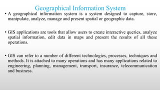
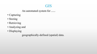
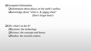
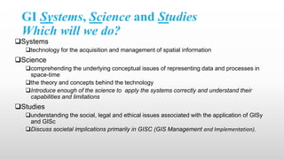
SlideShare a Scribd company logo
1 of 26
Presentation on
Geographical Information System
Presented by
Bipin Karki
Agriculture Instructor
Sarba Secondary School
Geographical Information System
• A geographical information system is a system designed to capture, store,
manipulate, analyze, manage and present spatial or geographic data.
• GIS applications are tools that allow users to create interactive queries, analyze
spatial information, edit data in maps and present the results of all these
operations.
• GIS can refer to a number of different technologies, processes, techniques and
methods. It is attached to many operations and has many applications related to
engineering, planning, management, transport, insurance, telecommunication
and business.
GIS
An automated system for ......
• Capturing
• Storing
• Retrieving
• Analyzing and
• Displaying
geographically-defined (spatial) data.
Geospatial Information
information about places on the earth’s surface
knowledge about “what is & where when”
(Don’t forget time!)
GIS--what’s in the S?
Systems: the technology
Science: the concepts and theory
Studies: the societal context
GI Systems, Science and Studies
Which will we do?
Systems
technology for the acquisition and management of spatial information
Science
comprehending the underlying conceptual issues of representing data and processes in
space-time
the theory and concepts behind the technology
Introduce enough of the science to apply the systems correctly and understand their
capabilities and limitations
Studies
understanding the social, legal and ethical issues associated with the application of GISy
and GISc
Discuss societal implications primarily in GISC (GIS Management and Implementation).
Geographical Information Technologies
Global Positioning Systems (GPS)
a system of earth-orbiting satellites which can provide precise (100 meter to sub-cm.)
location on the earth’s surface (in lat/long coordinates or equiv.)
Remote Sensing (RS)
use of satellites or aircraft to capture information about the earth’s surface
Digital ortho images a key product (map accurate digital photos)
Geographic Information Systems (GISy)
Software systems with capability for input, storage, manipulation/analysis and
output/display of geographic (spatial) information
• GPS and RS are sources of input data for a GISy.
• A GISy provides for storing and manipulating GPS and RS data
Scope and importance
• GIS in Education
GIS used in multiple disciplines: Agriculture, Archaeology,
Architecture/Landscape, Business, Computer Science Environmental
Science, Engineering, Journalism, Military Science, Natural Resource
Management, Geography, Geology Meteorology, Oceanography, Law
Enforcement, Public Health, History, Sociology Urban/Regional
Planning.
• Agriculture
-Farm management – Water management – Pest/Disease tracking –Crop
monitoring – Yield prediction – Soil analysis
• Natural Resource Management
Forestry -Ecology - Mining -Petroleum -Water Resources
• Planning and Economic Development
Land Use/Zoning -Emergency Preparedness - Population Forecast -Market Analysis
- Property Tax Assessment -Transportation
• Military and defense
-Battlefield management
-Satellite imagery interpretation
GIS: A Framework for Understanding and Managing Our Earth
• businesses
Use GIS for a very wide array of applications
‾ retail site selection & customer analysis
‾ logistics: vehicle tracking & routing
‾ natural resource exploration (petroleum, etc.)
• 80% of local government activities estimated to be geographically
based
‾ zoning, public works (streets, water supply, sewers), garbage
collection, land ownership and valuation, public safety (fire and
police)
• scientific research employs GIS
‾ geography, geology, Soil, botany, fishery
‾ anthropology, sociology, economics, political science
‾ Epidemiology, criminology
• Local Government
-Public works/infrastructure management (roads, water, sewer)
-Planning and environmental management
-property records and appraisal
• Real Estate and Marketing
-Retail site selection, site evaluation
• Public safety and defense
-Crime analysis, fire prevention, emergency management, military/defense
• Natural resource exploration/extraction
-Petroleum, minerals, quarrying
• Transportation
-Airline route planning, transportation planning/modeling
• Public health and epidemiology
• The Geospatial Industry
-Data development, application development, programming
Components of GIS
• Hardware
• Software
• Data
• People
• Methods
Hardware
• Hardware is computer on which GIS software runs.Nowadays there
are a different range of computer,it might be Desktop or server based.
• ArcGIS server is server based computer where GIS software runs on
network computer or cloud based.
• Components of hardware are:Motherboard(major hardware parts are
installed in it), Harddrive, Processor(CPU), RAM, Printer, External
Disk, Monitor
Software
• It provides tools to run and edit spatial information.
• It helps to query, edit, run and display GIS data.
• It uses
• Relational Database Management System to store data.
• Few software list are : ArcGis, ArcView, QQIS, SAGA GIS
Software components:
GIS tools(tools for browsing data), RDBMS(store data), Query tools(works
with RDBMS for querying, insertion, deletion, and Standard query
language), GUI(Graphical User Interface that helps user and software to
interact well), Layout(good layout windows to design map)
Data
• Data is the most important component of GIS. It is fuel of GIS.
• It is the combination of graphic and tabular data. Graphic can be vector
or raster.
• Both type of data can be created in house using GIS software or can be
purchased.
• The process of creating data from analog data or paper format is called
digitalization.
• Digitalization process involves registering of raster image using few
GCP(Ground Control Point) Or known coordinates. This process is
widely known as rubber sheeting or geo-referencing.
• Polygons, Lines and image are created by digitalizing raster image.
GIS data types
• Raster: Raster image store information in a cell based manner. It can
be aerial, photo, Satellite image, Digital elevation model.
Raster images normally store continuous data.
• Vector: Vector data are discrete. It stores information in x,y coordinate
format. There are 3 types of vector data: Lines, Points and area.
Peoples
• Users of GIS. Broadly 2 classes:
1. CAD/GIS operator: whose object is to vectorize map objects.
2. GIS Engineer: Who query and analyze works.
• They run the GIS software.
• Hardware and software have seen tremendous development which
made people easy to run the GIS software. Computer are affordable
so people are using it for GIS task.
Methods
• For successful GIS operation, Well designed plan and business
operations rules are important.
• Methods vary with different organizations.
• Organizations document their process plan for GIS operation. These
document address number question about GIS methods: No. of GIS
experts required, GIS software and hardware, Process to store the data,
type of DBMS and more.
• Map creation can be done by :
1. Automated raster
2. Vector Creator
3. Manually vectorised
4. Survey agency
GIS mapping
Components of maps
Scale
Used to show a portion of Earth's surface on earth
Small scale-1:1000000 Medium scale-1:175000 to 1:1000000 Large scale-
1:175000
Map resolution
Refers to how accurately the location and shape of map features can be
depicted for a given map scale. As map scale decreases, map resolution
decreases.
Map accuracy
Covers quality of source data, map scale, drafting skills and width of lines
on ground
GIS terminologies
• Attribute - A characteristic of a geographic feature, typically stored in
tabular format and linked to the feature in a relational database. The
attributes of a well-represented point might include an identification
number, address, and type.
• Base Layer - A primary layer for spatial reference, upon which other
layers are built. Examples of a base layer typically used are either the
parcels, or street centerlines.
• Buffer - A zone of a specified distance around a feature.
• Computer Aided Design (CAD) - An automated system for the design,
drafting and display of graphically oriented information.
• Database - A logical collection of interrelated information, managed
and stored as a unit. A GIS database includes data about the spatial
location and shape of geographic features recorded as points, lines, and
polygons as well as their attributes.
Digital Elevation Model (DEM) - Terrain elevation data provided in
digital form.
Digitize - To encode map features as x,y coordinates in digital form. Lines
are traced to define their shapes. This can be accomplished either manually
or by use of a scanner.
Geocode - The process of identifying a location by one or more attributes
from a base layer.
Layer - A logical set of thematic data described and stored in a map library.
Layers act as digital transparencies that can be laid atop one another for
viewing or spatial analysis.
Line – Lines represent geographic features too narrow to be displayed as
an area at a given scale, such as contours, street centerlines, or streams.
Metadata – Information about a data set. It may include the source of the data;
its creation date and format; its projection, scale, resolution, and accuracy; and
its reliability with regard to some standard.
Ortho Imagery - Aerial photographs that have been rectified to produce an
accurate image of the Earth by removing tilt and relief displacements, which
occurred when the photo was taken.
Point – A single x,y coordinate that represents a geographic feature too small to
be displayed as a line or area at that scale.
Polygon - A multisided figure that represents area on a map. Polygons have
attributes that describe the geographic feature they represent.
Scale – The ratio or relationship between a distance or area on a map and the
corresponding distance or area on the ground.
Spatial Analysis - The process of modeling, examining, and interpreting model
results. Spatial analysis is useful for evaluating suitability and capability, for
estimating and predicting, and for interpreting and understanding.
Structured Query Language (SQL) - A syntax for defining and manipulating
data from a relational database. Developed by IBM in the 1970s, it has become an
industry standard for query languages in most relational database management
systems.
Theme – An ArcView theme stores map features as primary features (such as
arcs, nodes, polygons, and points) and secondary features such as tics, map
extent, links, and annotation. A theme usually represents a single geographic
layer, such as soils, roads, or land use.
Base station: [surveying] A base station is a precisely surveyed location used as a
fixed Global Navigation Satellite System (GNSS) recording station. Base stations
are typically used in differential correction.
Bearing: [surveying] A bearing is a direction expressed as a geographic angle
measured from a base line used in surveying and navigation
Benchmark: [surveying] Benchmarks are precisely surveyed points
usually marked with a brass or metal disk in the ground. Benchmarks is a
generic term sometimes referred as survey marks, geodetic marks and
control stations.
GDAL: [GIS software] Geospatial Data Abstraction Library (GDAL) is a
C++ library for reading and writing raster geospatial data formats,
implementing common GIS operations (unions, intersections, joins,
clipping, etc.) with command line utilities. It supports old hardware and
operating systems and requires very low amounts of memory.
Generalization Tool: [GIS processing] The Generalization Tool is an
editing process that simplifies the shapes and edges of linear or polygon
features in a map. Using an offset tolerance, the output will reduce the
number of vertices used in the line or polygon.
Geocoding: [GIS processing] Geocoding is the process of assigning geographic coordinates
to places based on street address, town/city, province/state and country.
Arc: [data structure] Arcs are lines or polygon boundaries, represented as a series of
vertices or coordinate points.
ArcGIS: [software] ArcGIS is a GIS software package produced by the Environmental
Systems Research Institute (Esri) which allows you to collect, store, manage, visualize,
export, analyze and map geographic data. ArcGIS is a suite of spatial analysis tools and
cartographic features on a customizable user interface that allows you to be understand and
make decisions with spatial data.
ArcGlobe: [software] ArcGlobe is a global three-dimensional visualization and analysis
environment as part of the Esri ArcGIS suite (3D analyst), specializing in global datasets
and larger study areas.
Aspect: [GIS processing] Aspect is the slope direction on a terrain surface. Aspect is
measured clockwise starting North as 0° to 360° North again with flat areas given a value of
-1 (or 0 degrees).
GIS Presentation Summary

More Related Content

What's hot

Introduction to GIS
Introduction to GISIntroduction to GIS
Introduction to GISJoey Li
 
Landuse landcover mapping
Landuse landcover mappingLanduse landcover mapping
Landuse landcover mappingAditya Kushwaha
 
Chap1 introduction to geographic information system (gis)
Chap1 introduction to geographic information system (gis)Chap1 introduction to geographic information system (gis)
Chap1 introduction to geographic information system (gis)Mweemba Hachita
 
Understanding Coordinate Systems and Projections for ArcGIS
Understanding Coordinate Systems and Projections for ArcGISUnderstanding Coordinate Systems and Projections for ArcGIS
Understanding Coordinate Systems and Projections for ArcGISJohn Schaeffer
 
Gis Geographical Information System Fundamentals
Gis Geographical Information System FundamentalsGis Geographical Information System Fundamentals
Gis Geographical Information System FundamentalsUroosa Samman
 
Basic of gis concept and theories
Basic of gis concept and theoriesBasic of gis concept and theories
Basic of gis concept and theoriesMohsin Siddique
 
An introduction to geographic information systems (gis) m goulbourne 2007
An introduction to geographic information systems (gis)   m goulbourne 2007An introduction to geographic information systems (gis)   m goulbourne 2007
An introduction to geographic information systems (gis) m goulbourne 2007Michelle Goulbourne @ DiaMind Health
 
Getting started with GIS
Getting started with GISGetting started with GIS
Getting started with GISEsri India
 
Introduction to GIS systems
Introduction to GIS systemsIntroduction to GIS systems
Introduction to GIS systemsVivek Srivastava
 
Introduction to gis and arc gis
Introduction to gis and arc gis Introduction to gis and arc gis
Introduction to gis and arc gis Saad Raja
 

What's hot (20)

Introduction to GIS
Introduction to GISIntroduction to GIS
Introduction to GIS
 
Landuse landcover mapping
Landuse landcover mappingLanduse landcover mapping
Landuse landcover mapping
 
A short introduction to GIS
A short introduction to GISA short introduction to GIS
A short introduction to GIS
 
Gis
Gis Gis
Gis
 
Mobile gis
Mobile gisMobile gis
Mobile gis
 
Chap1 introduction to geographic information system (gis)
Chap1 introduction to geographic information system (gis)Chap1 introduction to geographic information system (gis)
Chap1 introduction to geographic information system (gis)
 
Introduction to GIS
Introduction to GISIntroduction to GIS
Introduction to GIS
 
GIS PPT
GIS PPTGIS PPT
GIS PPT
 
Digital Cartography
Digital CartographyDigital Cartography
Digital Cartography
 
Types of GIS Data
Types of GIS DataTypes of GIS Data
Types of GIS Data
 
Understanding Coordinate Systems and Projections for ArcGIS
Understanding Coordinate Systems and Projections for ArcGISUnderstanding Coordinate Systems and Projections for ArcGIS
Understanding Coordinate Systems and Projections for ArcGIS
 
Gis Geographical Information System Fundamentals
Gis Geographical Information System FundamentalsGis Geographical Information System Fundamentals
Gis Geographical Information System Fundamentals
 
Basic of gis concept and theories
Basic of gis concept and theoriesBasic of gis concept and theories
Basic of gis concept and theories
 
GIS data structure
GIS data structureGIS data structure
GIS data structure
 
An introduction to geographic information systems (gis) m goulbourne 2007
An introduction to geographic information systems (gis)   m goulbourne 2007An introduction to geographic information systems (gis)   m goulbourne 2007
An introduction to geographic information systems (gis) m goulbourne 2007
 
introduction to GIS
introduction to GIS introduction to GIS
introduction to GIS
 
Getting started with GIS
Getting started with GISGetting started with GIS
Getting started with GIS
 
Gis
GisGis
Gis
 
Introduction to GIS systems
Introduction to GIS systemsIntroduction to GIS systems
Introduction to GIS systems
 
Introduction to gis and arc gis
Introduction to gis and arc gis Introduction to gis and arc gis
Introduction to gis and arc gis
 

Similar to GIS Presentation Summary

EVS G.I.S CONCEPTS OF SCIENCE PPT.pptx
EVS  G.I.S CONCEPTS  OF SCIENCE PPT.pptxEVS  G.I.S CONCEPTS  OF SCIENCE PPT.pptx
EVS G.I.S CONCEPTS OF SCIENCE PPT.pptxUMANJUNATH
 
Introduction to Geographic Information Systems (GIS).pptx
Introduction to Geographic Information Systems (GIS).pptxIntroduction to Geographic Information Systems (GIS).pptx
Introduction to Geographic Information Systems (GIS).pptxUniversity of Colombo
 
TYBSC IT PGIS Unit I Chapter I- Introduction to Geographic Information Systems
TYBSC IT PGIS Unit I  Chapter I- Introduction to Geographic Information SystemsTYBSC IT PGIS Unit I  Chapter I- Introduction to Geographic Information Systems
TYBSC IT PGIS Unit I Chapter I- Introduction to Geographic Information SystemsArti Parab Academics
 
GEOGRAPHIC INFORMATION SYSTEM.pdf
GEOGRAPHIC INFORMATION SYSTEM.pdfGEOGRAPHIC INFORMATION SYSTEM.pdf
GEOGRAPHIC INFORMATION SYSTEM.pdfbalaramkumbhakar2
 
Lecture 1_ Intro n Basics_GIS.pptx
Lecture 1_ Intro n Basics_GIS.pptxLecture 1_ Intro n Basics_GIS.pptx
Lecture 1_ Intro n Basics_GIS.pptxnobelhasssan
 
1_GEOGRAPHIC INFORMATION SYSTEMSTEM.pptx
1_GEOGRAPHIC INFORMATION SYSTEMSTEM.pptx1_GEOGRAPHIC INFORMATION SYSTEMSTEM.pptx
1_GEOGRAPHIC INFORMATION SYSTEMSTEM.pptxLaleanePale
 
Introduction and Application of GIS
Introduction and Application of GISIntroduction and Application of GIS
Introduction and Application of GISSatish Taji
 
Introduction to GIS and its Applications.pptx
Introduction to GIS and its Applications.pptxIntroduction to GIS and its Applications.pptx
Introduction to GIS and its Applications.pptxalphamale15
 
Geographic Information System for Bachelor in Agriculture Engineering
Geographic Information System for Bachelor in Agriculture EngineeringGeographic Information System for Bachelor in Agriculture Engineering
Geographic Information System for Bachelor in Agriculture EngineeringDinesh Bishwakarma
 
GIS for geophysics.pptx
GIS for geophysics.pptxGIS for geophysics.pptx
GIS for geophysics.pptxThomasHundasa1
 

Similar to GIS Presentation Summary (20)

Geographical Information System
Geographical Information SystemGeographical Information System
Geographical Information System
 
gis.pdf
gis.pdfgis.pdf
gis.pdf
 
gis.pdf
gis.pdfgis.pdf
gis.pdf
 
EVS G.I.S CONCEPTS OF SCIENCE PPT.pptx
EVS  G.I.S CONCEPTS  OF SCIENCE PPT.pptxEVS  G.I.S CONCEPTS  OF SCIENCE PPT.pptx
EVS G.I.S CONCEPTS OF SCIENCE PPT.pptx
 
Rs unit iii-gis--- [repaired]
Rs unit iii-gis--- [repaired]Rs unit iii-gis--- [repaired]
Rs unit iii-gis--- [repaired]
 
Rs unit iii-gis--- [repaired]
Rs unit iii-gis--- [repaired]Rs unit iii-gis--- [repaired]
Rs unit iii-gis--- [repaired]
 
Introduction to Geographic Information Systems (GIS).pptx
Introduction to Geographic Information Systems (GIS).pptxIntroduction to Geographic Information Systems (GIS).pptx
Introduction to Geographic Information Systems (GIS).pptx
 
TYBSC IT PGIS Unit I Chapter I- Introduction to Geographic Information Systems
TYBSC IT PGIS Unit I  Chapter I- Introduction to Geographic Information SystemsTYBSC IT PGIS Unit I  Chapter I- Introduction to Geographic Information Systems
TYBSC IT PGIS Unit I Chapter I- Introduction to Geographic Information Systems
 
GEOGRAPHIC INFORMATION SYSTEM.pdf
GEOGRAPHIC INFORMATION SYSTEM.pdfGEOGRAPHIC INFORMATION SYSTEM.pdf
GEOGRAPHIC INFORMATION SYSTEM.pdf
 
Gis
GisGis
Gis
 
Lecture 1_ Intro n Basics_GIS.pptx
Lecture 1_ Intro n Basics_GIS.pptxLecture 1_ Intro n Basics_GIS.pptx
Lecture 1_ Intro n Basics_GIS.pptx
 
( G . i . s )
( G . i . s )( G . i . s )
( G . i . s )
 
Concept, approach, history, trend
Concept, approach, history, trendConcept, approach, history, trend
Concept, approach, history, trend
 
1_GEOGRAPHIC INFORMATION SYSTEMSTEM.pptx
1_GEOGRAPHIC INFORMATION SYSTEMSTEM.pptx1_GEOGRAPHIC INFORMATION SYSTEMSTEM.pptx
1_GEOGRAPHIC INFORMATION SYSTEMSTEM.pptx
 
Introduction and Application of GIS
Introduction and Application of GISIntroduction and Application of GIS
Introduction and Application of GIS
 
Introduction to GIS and its Applications.pptx
Introduction to GIS and its Applications.pptxIntroduction to GIS and its Applications.pptx
Introduction to GIS and its Applications.pptx
 
G I S.pptx
G I S.pptxG I S.pptx
G I S.pptx
 
Geographic Information System for Bachelor in Agriculture Engineering
Geographic Information System for Bachelor in Agriculture EngineeringGeographic Information System for Bachelor in Agriculture Engineering
Geographic Information System for Bachelor in Agriculture Engineering
 
GIS for geophysics.pptx
GIS for geophysics.pptxGIS for geophysics.pptx
GIS for geophysics.pptx
 
Geographical Information System.ppt
Geographical Information System.pptGeographical Information System.ppt
Geographical Information System.ppt
 

More from Bipin Karki

Insect order resham sir
Insect order resham sirInsect order resham sir
Insect order resham sirBipin Karki
 
Cucurbits production tech. in brief
Cucurbits production tech. in briefCucurbits production tech. in brief
Cucurbits production tech. in briefBipin Karki
 
Insect ecology presentation
Insect ecology presentationInsect ecology presentation
Insect ecology presentationBipin Karki
 
Geographical information system
Geographical information systemGeographical information system
Geographical information systemBipin Karki
 
Basic concept of environmental pollution
Basic concept of environmental pollutionBasic concept of environmental pollution
Basic concept of environmental pollutionBipin Karki
 
Strawberry production technology
Strawberry production technologyStrawberry production technology
Strawberry production technologyBipin Karki
 
Guava wilt and cotton wilt
Guava wilt and cotton wiltGuava wilt and cotton wilt
Guava wilt and cotton wiltBipin Karki
 
Critical evaluation of 4th, 5th, and 6th year plan
Critical evaluation of 4th, 5th, and 6th year planCritical evaluation of 4th, 5th, and 6th year plan
Critical evaluation of 4th, 5th, and 6th year planBipin Karki
 

More from Bipin Karki (8)

Insect order resham sir
Insect order resham sirInsect order resham sir
Insect order resham sir
 
Cucurbits production tech. in brief
Cucurbits production tech. in briefCucurbits production tech. in brief
Cucurbits production tech. in brief
 
Insect ecology presentation
Insect ecology presentationInsect ecology presentation
Insect ecology presentation
 
Geographical information system
Geographical information systemGeographical information system
Geographical information system
 
Basic concept of environmental pollution
Basic concept of environmental pollutionBasic concept of environmental pollution
Basic concept of environmental pollution
 
Strawberry production technology
Strawberry production technologyStrawberry production technology
Strawberry production technology
 
Guava wilt and cotton wilt
Guava wilt and cotton wiltGuava wilt and cotton wilt
Guava wilt and cotton wilt
 
Critical evaluation of 4th, 5th, and 6th year plan
Critical evaluation of 4th, 5th, and 6th year planCritical evaluation of 4th, 5th, and 6th year plan
Critical evaluation of 4th, 5th, and 6th year plan
 

Recently uploaded

如何办理(Adelaide毕业证)阿德莱德大学毕业证成绩单Adelaide学历认证真实可查
如何办理(Adelaide毕业证)阿德莱德大学毕业证成绩单Adelaide学历认证真实可查如何办理(Adelaide毕业证)阿德莱德大学毕业证成绩单Adelaide学历认证真实可查
如何办理(Adelaide毕业证)阿德莱德大学毕业证成绩单Adelaide学历认证真实可查awo24iot
 
VIP Call Girl Saharanpur Aashi 8250192130 Independent Escort Service Saharanpur
VIP Call Girl Saharanpur Aashi 8250192130 Independent Escort Service SaharanpurVIP Call Girl Saharanpur Aashi 8250192130 Independent Escort Service Saharanpur
VIP Call Girl Saharanpur Aashi 8250192130 Independent Escort Service SaharanpurSuhani Kapoor
 
VVIP Pune Call Girls Balaji Nagar (7001035870) Pune Escorts Nearby with Compl...
VVIP Pune Call Girls Balaji Nagar (7001035870) Pune Escorts Nearby with Compl...VVIP Pune Call Girls Balaji Nagar (7001035870) Pune Escorts Nearby with Compl...
VVIP Pune Call Girls Balaji Nagar (7001035870) Pune Escorts Nearby with Compl...Call Girls in Nagpur High Profile
 
Lucknow 💋 Call Girls Adil Nagar | ₹,9500 Pay Cash 8923113531 Free Home Delive...
Lucknow 💋 Call Girls Adil Nagar | ₹,9500 Pay Cash 8923113531 Free Home Delive...Lucknow 💋 Call Girls Adil Nagar | ₹,9500 Pay Cash 8923113531 Free Home Delive...
Lucknow 💋 Call Girls Adil Nagar | ₹,9500 Pay Cash 8923113531 Free Home Delive...anilsa9823
 
9004554577, Get Adorable Call Girls service. Book call girls & escort service...
9004554577, Get Adorable Call Girls service. Book call girls & escort service...9004554577, Get Adorable Call Girls service. Book call girls & escort service...
9004554577, Get Adorable Call Girls service. Book call girls & escort service...Pooja Nehwal
 
如何办理萨省大学毕业证(UofS毕业证)成绩单留信学历认证原版一比一
如何办理萨省大学毕业证(UofS毕业证)成绩单留信学历认证原版一比一如何办理萨省大学毕业证(UofS毕业证)成绩单留信学历认证原版一比一
如何办理萨省大学毕业证(UofS毕业证)成绩单留信学历认证原版一比一ga6c6bdl
 
9892124323 Pooja Nehwal Call Girls Services Call Girls service in Santacruz A...
9892124323 Pooja Nehwal Call Girls Services Call Girls service in Santacruz A...9892124323 Pooja Nehwal Call Girls Services Call Girls service in Santacruz A...
9892124323 Pooja Nehwal Call Girls Services Call Girls service in Santacruz A...Pooja Nehwal
 
Gaya Call Girls #9907093804 Contact Number Escorts Service Gaya
Gaya Call Girls #9907093804 Contact Number Escorts Service GayaGaya Call Girls #9907093804 Contact Number Escorts Service Gaya
Gaya Call Girls #9907093804 Contact Number Escorts Service Gayasrsj9000
 
FULL ENJOY - 8264348440 Call Girls in Hauz Khas | Delhi
FULL ENJOY - 8264348440 Call Girls in Hauz Khas | DelhiFULL ENJOY - 8264348440 Call Girls in Hauz Khas | Delhi
FULL ENJOY - 8264348440 Call Girls in Hauz Khas | Delhisoniya singh
 
9892124323, Call Girl in Juhu Call Girls Services (Rate ₹8.5K) 24×7 with Hote...
9892124323, Call Girl in Juhu Call Girls Services (Rate ₹8.5K) 24×7 with Hote...9892124323, Call Girl in Juhu Call Girls Services (Rate ₹8.5K) 24×7 with Hote...
9892124323, Call Girl in Juhu Call Girls Services (Rate ₹8.5K) 24×7 with Hote...Pooja Nehwal
 
(ZARA) Call Girls Jejuri ( 7001035870 ) HI-Fi Pune Escorts Service
(ZARA) Call Girls Jejuri ( 7001035870 ) HI-Fi Pune Escorts Service(ZARA) Call Girls Jejuri ( 7001035870 ) HI-Fi Pune Escorts Service
(ZARA) Call Girls Jejuri ( 7001035870 ) HI-Fi Pune Escorts Serviceranjana rawat
 
High Profile Call Girls In Andheri 7738631006 Call girls in mumbai Mumbai ...
High Profile Call Girls In Andheri 7738631006 Call girls in mumbai  Mumbai ...High Profile Call Girls In Andheri 7738631006 Call girls in mumbai  Mumbai ...
High Profile Call Girls In Andheri 7738631006 Call girls in mumbai Mumbai ...Pooja Nehwal
 
VVIP Pune Call Girls Warje (7001035870) Pune Escorts Nearby with Complete Sat...
VVIP Pune Call Girls Warje (7001035870) Pune Escorts Nearby with Complete Sat...VVIP Pune Call Girls Warje (7001035870) Pune Escorts Nearby with Complete Sat...
VVIP Pune Call Girls Warje (7001035870) Pune Escorts Nearby with Complete Sat...Call Girls in Nagpur High Profile
 
WhatsApp 9892124323 ✓Call Girls In Khar ( Mumbai ) secure service - Bandra F...
WhatsApp 9892124323 ✓Call Girls In Khar ( Mumbai ) secure service -  Bandra F...WhatsApp 9892124323 ✓Call Girls In Khar ( Mumbai ) secure service -  Bandra F...
WhatsApp 9892124323 ✓Call Girls In Khar ( Mumbai ) secure service - Bandra F...Pooja Nehwal
 
Dubai Call Girls O528786472 Call Girls In Dubai Wisteria
Dubai Call Girls O528786472 Call Girls In Dubai WisteriaDubai Call Girls O528786472 Call Girls In Dubai Wisteria
Dubai Call Girls O528786472 Call Girls In Dubai WisteriaUnited Arab Emirates
 
Russian Call Girls Kolkata Chhaya 🤌 8250192130 🚀 Vip Call Girls Kolkata
Russian Call Girls Kolkata Chhaya 🤌  8250192130 🚀 Vip Call Girls KolkataRussian Call Girls Kolkata Chhaya 🤌  8250192130 🚀 Vip Call Girls Kolkata
Russian Call Girls Kolkata Chhaya 🤌 8250192130 🚀 Vip Call Girls Kolkataanamikaraghav4
 
(SANA) Call Girls Landewadi ( 7001035870 ) HI-Fi Pune Escorts Service
(SANA) Call Girls Landewadi ( 7001035870 ) HI-Fi Pune Escorts Service(SANA) Call Girls Landewadi ( 7001035870 ) HI-Fi Pune Escorts Service
(SANA) Call Girls Landewadi ( 7001035870 ) HI-Fi Pune Escorts Serviceranjana rawat
 
Call Girls in Dwarka Sub City 💯Call Us 🔝8264348440🔝
Call Girls in Dwarka Sub City 💯Call Us 🔝8264348440🔝Call Girls in Dwarka Sub City 💯Call Us 🔝8264348440🔝
Call Girls in Dwarka Sub City 💯Call Us 🔝8264348440🔝soniya singh
 

Recently uploaded (20)

如何办理(Adelaide毕业证)阿德莱德大学毕业证成绩单Adelaide学历认证真实可查
如何办理(Adelaide毕业证)阿德莱德大学毕业证成绩单Adelaide学历认证真实可查如何办理(Adelaide毕业证)阿德莱德大学毕业证成绩单Adelaide学历认证真实可查
如何办理(Adelaide毕业证)阿德莱德大学毕业证成绩单Adelaide学历认证真实可查
 
9953330565 Low Rate Call Girls In Jahangirpuri Delhi NCR
9953330565 Low Rate Call Girls In Jahangirpuri  Delhi NCR9953330565 Low Rate Call Girls In Jahangirpuri  Delhi NCR
9953330565 Low Rate Call Girls In Jahangirpuri Delhi NCR
 
VIP Call Girl Saharanpur Aashi 8250192130 Independent Escort Service Saharanpur
VIP Call Girl Saharanpur Aashi 8250192130 Independent Escort Service SaharanpurVIP Call Girl Saharanpur Aashi 8250192130 Independent Escort Service Saharanpur
VIP Call Girl Saharanpur Aashi 8250192130 Independent Escort Service Saharanpur
 
VVIP Pune Call Girls Balaji Nagar (7001035870) Pune Escorts Nearby with Compl...
VVIP Pune Call Girls Balaji Nagar (7001035870) Pune Escorts Nearby with Compl...VVIP Pune Call Girls Balaji Nagar (7001035870) Pune Escorts Nearby with Compl...
VVIP Pune Call Girls Balaji Nagar (7001035870) Pune Escorts Nearby with Compl...
 
Low rate Call girls in Delhi Justdial | 9953330565
Low rate Call girls in Delhi Justdial | 9953330565Low rate Call girls in Delhi Justdial | 9953330565
Low rate Call girls in Delhi Justdial | 9953330565
 
Lucknow 💋 Call Girls Adil Nagar | ₹,9500 Pay Cash 8923113531 Free Home Delive...
Lucknow 💋 Call Girls Adil Nagar | ₹,9500 Pay Cash 8923113531 Free Home Delive...Lucknow 💋 Call Girls Adil Nagar | ₹,9500 Pay Cash 8923113531 Free Home Delive...
Lucknow 💋 Call Girls Adil Nagar | ₹,9500 Pay Cash 8923113531 Free Home Delive...
 
9004554577, Get Adorable Call Girls service. Book call girls & escort service...
9004554577, Get Adorable Call Girls service. Book call girls & escort service...9004554577, Get Adorable Call Girls service. Book call girls & escort service...
9004554577, Get Adorable Call Girls service. Book call girls & escort service...
 
如何办理萨省大学毕业证(UofS毕业证)成绩单留信学历认证原版一比一
如何办理萨省大学毕业证(UofS毕业证)成绩单留信学历认证原版一比一如何办理萨省大学毕业证(UofS毕业证)成绩单留信学历认证原版一比一
如何办理萨省大学毕业证(UofS毕业证)成绩单留信学历认证原版一比一
 
9892124323 Pooja Nehwal Call Girls Services Call Girls service in Santacruz A...
9892124323 Pooja Nehwal Call Girls Services Call Girls service in Santacruz A...9892124323 Pooja Nehwal Call Girls Services Call Girls service in Santacruz A...
9892124323 Pooja Nehwal Call Girls Services Call Girls service in Santacruz A...
 
Gaya Call Girls #9907093804 Contact Number Escorts Service Gaya
Gaya Call Girls #9907093804 Contact Number Escorts Service GayaGaya Call Girls #9907093804 Contact Number Escorts Service Gaya
Gaya Call Girls #9907093804 Contact Number Escorts Service Gaya
 
FULL ENJOY - 8264348440 Call Girls in Hauz Khas | Delhi
FULL ENJOY - 8264348440 Call Girls in Hauz Khas | DelhiFULL ENJOY - 8264348440 Call Girls in Hauz Khas | Delhi
FULL ENJOY - 8264348440 Call Girls in Hauz Khas | Delhi
 
9892124323, Call Girl in Juhu Call Girls Services (Rate ₹8.5K) 24×7 with Hote...
9892124323, Call Girl in Juhu Call Girls Services (Rate ₹8.5K) 24×7 with Hote...9892124323, Call Girl in Juhu Call Girls Services (Rate ₹8.5K) 24×7 with Hote...
9892124323, Call Girl in Juhu Call Girls Services (Rate ₹8.5K) 24×7 with Hote...
 
(ZARA) Call Girls Jejuri ( 7001035870 ) HI-Fi Pune Escorts Service
(ZARA) Call Girls Jejuri ( 7001035870 ) HI-Fi Pune Escorts Service(ZARA) Call Girls Jejuri ( 7001035870 ) HI-Fi Pune Escorts Service
(ZARA) Call Girls Jejuri ( 7001035870 ) HI-Fi Pune Escorts Service
 
High Profile Call Girls In Andheri 7738631006 Call girls in mumbai Mumbai ...
High Profile Call Girls In Andheri 7738631006 Call girls in mumbai  Mumbai ...High Profile Call Girls In Andheri 7738631006 Call girls in mumbai  Mumbai ...
High Profile Call Girls In Andheri 7738631006 Call girls in mumbai Mumbai ...
 
VVIP Pune Call Girls Warje (7001035870) Pune Escorts Nearby with Complete Sat...
VVIP Pune Call Girls Warje (7001035870) Pune Escorts Nearby with Complete Sat...VVIP Pune Call Girls Warje (7001035870) Pune Escorts Nearby with Complete Sat...
VVIP Pune Call Girls Warje (7001035870) Pune Escorts Nearby with Complete Sat...
 
WhatsApp 9892124323 ✓Call Girls In Khar ( Mumbai ) secure service - Bandra F...
WhatsApp 9892124323 ✓Call Girls In Khar ( Mumbai ) secure service -  Bandra F...WhatsApp 9892124323 ✓Call Girls In Khar ( Mumbai ) secure service -  Bandra F...
WhatsApp 9892124323 ✓Call Girls In Khar ( Mumbai ) secure service - Bandra F...
 
Dubai Call Girls O528786472 Call Girls In Dubai Wisteria
Dubai Call Girls O528786472 Call Girls In Dubai WisteriaDubai Call Girls O528786472 Call Girls In Dubai Wisteria
Dubai Call Girls O528786472 Call Girls In Dubai Wisteria
 
Russian Call Girls Kolkata Chhaya 🤌 8250192130 🚀 Vip Call Girls Kolkata
Russian Call Girls Kolkata Chhaya 🤌  8250192130 🚀 Vip Call Girls KolkataRussian Call Girls Kolkata Chhaya 🤌  8250192130 🚀 Vip Call Girls Kolkata
Russian Call Girls Kolkata Chhaya 🤌 8250192130 🚀 Vip Call Girls Kolkata
 
(SANA) Call Girls Landewadi ( 7001035870 ) HI-Fi Pune Escorts Service
(SANA) Call Girls Landewadi ( 7001035870 ) HI-Fi Pune Escorts Service(SANA) Call Girls Landewadi ( 7001035870 ) HI-Fi Pune Escorts Service
(SANA) Call Girls Landewadi ( 7001035870 ) HI-Fi Pune Escorts Service
 
Call Girls in Dwarka Sub City 💯Call Us 🔝8264348440🔝
Call Girls in Dwarka Sub City 💯Call Us 🔝8264348440🔝Call Girls in Dwarka Sub City 💯Call Us 🔝8264348440🔝
Call Girls in Dwarka Sub City 💯Call Us 🔝8264348440🔝
 

GIS Presentation Summary

  • 1. Presentation on Geographical Information System Presented by Bipin Karki Agriculture Instructor Sarba Secondary School
  • 2. Geographical Information System • A geographical information system is a system designed to capture, store, manipulate, analyze, manage and present spatial or geographic data. • GIS applications are tools that allow users to create interactive queries, analyze spatial information, edit data in maps and present the results of all these operations. • GIS can refer to a number of different technologies, processes, techniques and methods. It is attached to many operations and has many applications related to engineering, planning, management, transport, insurance, telecommunication and business.
  • 3. GIS An automated system for ...... • Capturing • Storing • Retrieving • Analyzing and • Displaying geographically-defined (spatial) data.
  • 4. Geospatial Information information about places on the earth’s surface knowledge about “what is & where when” (Don’t forget time!) GIS--what’s in the S? Systems: the technology Science: the concepts and theory Studies: the societal context
  • 5. GI Systems, Science and Studies Which will we do? Systems technology for the acquisition and management of spatial information Science comprehending the underlying conceptual issues of representing data and processes in space-time the theory and concepts behind the technology Introduce enough of the science to apply the systems correctly and understand their capabilities and limitations Studies understanding the social, legal and ethical issues associated with the application of GISy and GISc Discuss societal implications primarily in GISC (GIS Management and Implementation).
  • 6. Geographical Information Technologies Global Positioning Systems (GPS) a system of earth-orbiting satellites which can provide precise (100 meter to sub-cm.) location on the earth’s surface (in lat/long coordinates or equiv.) Remote Sensing (RS) use of satellites or aircraft to capture information about the earth’s surface Digital ortho images a key product (map accurate digital photos) Geographic Information Systems (GISy) Software systems with capability for input, storage, manipulation/analysis and output/display of geographic (spatial) information • GPS and RS are sources of input data for a GISy. • A GISy provides for storing and manipulating GPS and RS data
  • 7. Scope and importance • GIS in Education GIS used in multiple disciplines: Agriculture, Archaeology, Architecture/Landscape, Business, Computer Science Environmental Science, Engineering, Journalism, Military Science, Natural Resource Management, Geography, Geology Meteorology, Oceanography, Law Enforcement, Public Health, History, Sociology Urban/Regional Planning. • Agriculture -Farm management – Water management – Pest/Disease tracking –Crop monitoring – Yield prediction – Soil analysis
  • 8. • Natural Resource Management Forestry -Ecology - Mining -Petroleum -Water Resources • Planning and Economic Development Land Use/Zoning -Emergency Preparedness - Population Forecast -Market Analysis - Property Tax Assessment -Transportation • Military and defense -Battlefield management -Satellite imagery interpretation GIS: A Framework for Understanding and Managing Our Earth
  • 9. • businesses Use GIS for a very wide array of applications ‾ retail site selection & customer analysis ‾ logistics: vehicle tracking & routing ‾ natural resource exploration (petroleum, etc.) • 80% of local government activities estimated to be geographically based ‾ zoning, public works (streets, water supply, sewers), garbage collection, land ownership and valuation, public safety (fire and police) • scientific research employs GIS ‾ geography, geology, Soil, botany, fishery ‾ anthropology, sociology, economics, political science ‾ Epidemiology, criminology
  • 10. • Local Government -Public works/infrastructure management (roads, water, sewer) -Planning and environmental management -property records and appraisal • Real Estate and Marketing -Retail site selection, site evaluation • Public safety and defense -Crime analysis, fire prevention, emergency management, military/defense • Natural resource exploration/extraction -Petroleum, minerals, quarrying • Transportation -Airline route planning, transportation planning/modeling • Public health and epidemiology • The Geospatial Industry -Data development, application development, programming
  • 11. Components of GIS • Hardware • Software • Data • People • Methods
  • 12. Hardware • Hardware is computer on which GIS software runs.Nowadays there are a different range of computer,it might be Desktop or server based. • ArcGIS server is server based computer where GIS software runs on network computer or cloud based. • Components of hardware are:Motherboard(major hardware parts are installed in it), Harddrive, Processor(CPU), RAM, Printer, External Disk, Monitor
  • 13. Software • It provides tools to run and edit spatial information. • It helps to query, edit, run and display GIS data. • It uses • Relational Database Management System to store data. • Few software list are : ArcGis, ArcView, QQIS, SAGA GIS Software components: GIS tools(tools for browsing data), RDBMS(store data), Query tools(works with RDBMS for querying, insertion, deletion, and Standard query language), GUI(Graphical User Interface that helps user and software to interact well), Layout(good layout windows to design map)
  • 14.
  • 15. Data • Data is the most important component of GIS. It is fuel of GIS. • It is the combination of graphic and tabular data. Graphic can be vector or raster. • Both type of data can be created in house using GIS software or can be purchased. • The process of creating data from analog data or paper format is called digitalization. • Digitalization process involves registering of raster image using few GCP(Ground Control Point) Or known coordinates. This process is widely known as rubber sheeting or geo-referencing. • Polygons, Lines and image are created by digitalizing raster image.
  • 16. GIS data types • Raster: Raster image store information in a cell based manner. It can be aerial, photo, Satellite image, Digital elevation model. Raster images normally store continuous data. • Vector: Vector data are discrete. It stores information in x,y coordinate format. There are 3 types of vector data: Lines, Points and area.
  • 17. Peoples • Users of GIS. Broadly 2 classes: 1. CAD/GIS operator: whose object is to vectorize map objects. 2. GIS Engineer: Who query and analyze works. • They run the GIS software. • Hardware and software have seen tremendous development which made people easy to run the GIS software. Computer are affordable so people are using it for GIS task.
  • 18. Methods • For successful GIS operation, Well designed plan and business operations rules are important. • Methods vary with different organizations. • Organizations document their process plan for GIS operation. These document address number question about GIS methods: No. of GIS experts required, GIS software and hardware, Process to store the data, type of DBMS and more. • Map creation can be done by : 1. Automated raster 2. Vector Creator 3. Manually vectorised 4. Survey agency
  • 19. GIS mapping Components of maps Scale Used to show a portion of Earth's surface on earth Small scale-1:1000000 Medium scale-1:175000 to 1:1000000 Large scale- 1:175000 Map resolution Refers to how accurately the location and shape of map features can be depicted for a given map scale. As map scale decreases, map resolution decreases. Map accuracy Covers quality of source data, map scale, drafting skills and width of lines on ground
  • 20. GIS terminologies • Attribute - A characteristic of a geographic feature, typically stored in tabular format and linked to the feature in a relational database. The attributes of a well-represented point might include an identification number, address, and type. • Base Layer - A primary layer for spatial reference, upon which other layers are built. Examples of a base layer typically used are either the parcels, or street centerlines. • Buffer - A zone of a specified distance around a feature. • Computer Aided Design (CAD) - An automated system for the design, drafting and display of graphically oriented information. • Database - A logical collection of interrelated information, managed and stored as a unit. A GIS database includes data about the spatial location and shape of geographic features recorded as points, lines, and polygons as well as their attributes.
  • 21. Digital Elevation Model (DEM) - Terrain elevation data provided in digital form. Digitize - To encode map features as x,y coordinates in digital form. Lines are traced to define their shapes. This can be accomplished either manually or by use of a scanner. Geocode - The process of identifying a location by one or more attributes from a base layer. Layer - A logical set of thematic data described and stored in a map library. Layers act as digital transparencies that can be laid atop one another for viewing or spatial analysis. Line – Lines represent geographic features too narrow to be displayed as an area at a given scale, such as contours, street centerlines, or streams.
  • 22. Metadata – Information about a data set. It may include the source of the data; its creation date and format; its projection, scale, resolution, and accuracy; and its reliability with regard to some standard. Ortho Imagery - Aerial photographs that have been rectified to produce an accurate image of the Earth by removing tilt and relief displacements, which occurred when the photo was taken. Point – A single x,y coordinate that represents a geographic feature too small to be displayed as a line or area at that scale. Polygon - A multisided figure that represents area on a map. Polygons have attributes that describe the geographic feature they represent. Scale – The ratio or relationship between a distance or area on a map and the corresponding distance or area on the ground. Spatial Analysis - The process of modeling, examining, and interpreting model results. Spatial analysis is useful for evaluating suitability and capability, for estimating and predicting, and for interpreting and understanding.
  • 23. Structured Query Language (SQL) - A syntax for defining and manipulating data from a relational database. Developed by IBM in the 1970s, it has become an industry standard for query languages in most relational database management systems. Theme – An ArcView theme stores map features as primary features (such as arcs, nodes, polygons, and points) and secondary features such as tics, map extent, links, and annotation. A theme usually represents a single geographic layer, such as soils, roads, or land use. Base station: [surveying] A base station is a precisely surveyed location used as a fixed Global Navigation Satellite System (GNSS) recording station. Base stations are typically used in differential correction. Bearing: [surveying] A bearing is a direction expressed as a geographic angle measured from a base line used in surveying and navigation
  • 24. Benchmark: [surveying] Benchmarks are precisely surveyed points usually marked with a brass or metal disk in the ground. Benchmarks is a generic term sometimes referred as survey marks, geodetic marks and control stations. GDAL: [GIS software] Geospatial Data Abstraction Library (GDAL) is a C++ library for reading and writing raster geospatial data formats, implementing common GIS operations (unions, intersections, joins, clipping, etc.) with command line utilities. It supports old hardware and operating systems and requires very low amounts of memory. Generalization Tool: [GIS processing] The Generalization Tool is an editing process that simplifies the shapes and edges of linear or polygon features in a map. Using an offset tolerance, the output will reduce the number of vertices used in the line or polygon.
  • 25. Geocoding: [GIS processing] Geocoding is the process of assigning geographic coordinates to places based on street address, town/city, province/state and country. Arc: [data structure] Arcs are lines or polygon boundaries, represented as a series of vertices or coordinate points. ArcGIS: [software] ArcGIS is a GIS software package produced by the Environmental Systems Research Institute (Esri) which allows you to collect, store, manage, visualize, export, analyze and map geographic data. ArcGIS is a suite of spatial analysis tools and cartographic features on a customizable user interface that allows you to be understand and make decisions with spatial data. ArcGlobe: [software] ArcGlobe is a global three-dimensional visualization and analysis environment as part of the Esri ArcGIS suite (3D analyst), specializing in global datasets and larger study areas. Aspect: [GIS processing] Aspect is the slope direction on a terrain surface. Aspect is measured clockwise starting North as 0° to 360° North again with flat areas given a value of -1 (or 0 degrees).