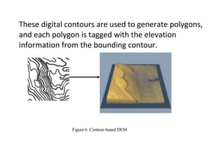
SlideShare a Scribd company logo
1 of 33
Download to read offline
DIGITAL ELEVATION MODEL (DEM) IN GIS
by
Prof. A. Balasubramanian
Centre for Advanced Studies in Earth Science,
University of Mysore, Mysore
Introduction:
Digital Elevation Model (DEM) is the digital
representation of the land surface elevation with
respect to any reference datum.
DEM is frequently used to refer to any digital
representation of a topographic surface.
DEM is the simplest form of digital representation of
topography .
DEMs are used to determine terrain attributes such
as elevation at any point, slope and aspect.
Terrain features like drainage basins and channel
networks can also be identified from the DEMs.
DEMs are widely used in hydrologic and geologic
analyses, hazard monitoring, natural resources
exploration, agricultural management etc.
Hydrologic applications of the DEM include
groundwater modeling, estimation of the volume of
proposed reservoirs, determining landslide
probability, flood prone area mapping etc.
Three main type of structures used are the following.
a) Regular square grids
b) Triangulated irregular networks (TIN) c) Contours.
A digital elevation model (DEM) is a digital model or
3D representation of a terrain's surface, created from
terrain elevation data.
There are three similar names as digital elevation
model (DEM), digital terrain model (DTM) and digital
surface model (DSM).
DEM is a subset of the DTM, which also represents
other morphological elements.
Creation of DEMs:
Several methods are available to create DEM.
a) Conversion of printed contour lines
The first method is conversion of printed contour
lines and use it in raster or vector form.
The elevation contours are "tagged" with elevations.
Any other additional elevation data are created from
the hydrography layer.
Finally, an algorithm is used to interpolate
elevations at every grid point from the contour data.
b) Photogrammetry:
This can be done manually or automatically:
i) Manually, an operator looks at a pair of
stereophotos through a stereoplotter and must
move two dots together until they appear to be
one lying just at the surface of the ground
ii) Automatically, an instrument calculates the
parallax displacement of a large number of points.
Types of DEM:
A DEM can be represented as a raster (a grid of
squares, also known as a heightmap when
representing elevation) or as a vector-based
triangular irregular network (TIN).
The TIN DEM dataset is also referred to as a primary
(measured) DEM, whereas the Raster DEM is
referred to as a secondary (computed) DEM.
A 7.5-Minute DEM covers 30- x 30-meter data
spacing.
Production:
Mappers may prepare digital elevation models in a
number of ways, but they frequently use remote
sensing rather than direct survey data.
One powerful technique for generating digital
elevation models is interferometric synthetic
aperture radar where two passes of a radar satellite.
DEMs are commonly built using data collected using
remote sensing techniques, but they may also be
built from land surveying.
DEMs are used often in geographic information
systems, and are the most common basis for digitally
produced relief maps.
The SPOT 1 satellite (1986) provided the first usable
elevation data for a sizeable portion of the planet's
landmass.
Older methods of generating DEMs often involve
interpolating digital contour maps that may have
been produced by direct survey of the land surface.
Several factors play an important role for quality of
DEM-derived products:
terrain roughness;
sampling density (elevation data collection method);
grid resolution or pixel size;
interpolation algorithm;
vertical resolution;
terrain analysis algorithm;
Reference 3D products include quality masks that
give information on the coastline, lake, snow, clouds,
correlation etc.
Methods for obtaining elevation data used to create
DEMs:
Lidar-Light Detection And Ranging (sometimes Light
Imaging, Detection, And Ranging)
Stereo photogrammetry from aerial surveys
Multi-view stereo applied to aerial photography
Interferometry from radar data
Real Time Kinematic GPS
Topographic maps
Theodolite or total station
Doppler radar
Surveying and mapping drones
Range imaging.
Gridded structure :
Gridded DEM (GDEM) consists of regularly placed,
uniform grids with the elevation information of each
grid.
The GDEM thus gives a readily usable dataset that
represents the elevation of surface as a function of
geographic location at regularly spaced horizontal
(square) grids.
Measure of quality:
The quality of a DEM depends on its horizontal and
vertical accuracy.
Accuracy of the GDEM and the size of the data
depend on the grid size.
TIN structure :
TIN is a more robust way of storing the spatially
varying information.
It uses irregular sampling points connected through
non-overlapping triangles.
The vertices of the triangles match with the surface
elevation of the sampling point and the triangles
(facets) represent the planes connecting the points.
Contour-based structure :
Contours represent points having equal heights/
elevations with respect to a particular datum such as
Mean Sea Level (MSL).
In the contour-based structure, the contour lines are
traced from the topographic maps and are stored
with their location (x, y) and elevation information.
These digital contours are used to generate polygons,
and each polygon is tagged with the elevation
information from the bounding contour.
Common uses of DEMs :
Extracting terrain parameters.
Modeling water flow or mass movement (for
example, landslides).
Creation of relief maps.
Rendering of 3D visualizations
Creation of physical models (including raised-relief
maps).
Rectification of aerial photography or satellite
imagery.
Reduction (terrain correction) of gravity
measurements (gravimetry, physical geodesy).
Terrain analyses in geomorphology and physical
geography.
DEM is used to determine the attributes of terrain,
such as elevation at any point, slope and aspect.
DEM is also used to find features on the terrain,
such as drainage basins and watersheds, drainage
networks and channels, peaks and pits and other
landforms.
Modeling of hydrologic functions, energy flux and
forest fires, etc can be done using DEM data.
Determination of the drainage network and the
associated drainage divides provides an important
first step in the creation of a hydrologic information
system.
DEM applications:
1) Estimating elevation
2) Estimating slope and aspect
3)Determining drainage networks
4) Determining the watershed
5) Terrain stability – Areas prone to avalanches are
high slope areas with sparse vegetation, which is
useful when planning a highway or residential
subdivision.
6) Soil mapping – DEMs assist in mapping soils which
is a function of elevation (as well as geology, time
and climate).
7) To create a profile graph from digitized features of
a surface.
Digital Elevation Model (DEM), consists of a sampled
array of elevations for a number of ground positions
at regularly spaced intervals, as shown in this fig.
LIDAR and DEM:
Light Detection and Ranging (LIDAR) sensors operate
on the same principle as that of laser equipment.
Pulses are sent from a laser onboard an aircraft and
the scattered pulses are recorded.
The time lapse for the returning pulses is used to
determine the two-way distance to the object.
LIDAR uses a sharp beam with high energy and hence
high resolution can be achieved.
It also enables DEM generation of a large area within
a short period of time with minimum human
dependence.
The disadvantage of procuring high resolution LIDAR
data is the expense involved in data collection.
Satellite interferometry with synthetic aperture
radar such as Shuttle Radar Topography Mission uses
two radar images from antennas at the same time to
create DEM.
SRTM (Shuttle Radar Tomography Mission) is a good
source of DEM data for almost anywhere in the
world. The CGIAR-CSI GeoPortal is able to provide
SRTM 90m Digital Elevation Data for the entire world.
The SRTM digital elevation data, produced by NASA
originally, is a major breakthrough in digital mapping
of the world, and provides a major advance in the
accessibility of high quality elevation data for large
portions of the tropics and other areas of the
developing world.
The SRTM digital elevation data provided on this site
has been processed to fill data voids, and to facilitate
it's ease of use by a wide group of potential users.
The NASA Shuttle Radar Topographic Mission (SRTM)
has provided digital elevation data (DEMs) for over
80% of the globe.
This data is currently distributed free of charge by
USGS.
USGS DEMs are raster grids of elevation values that
are arrayed in series of south-north profiles.
Like other USGS data, DEMs were produced originally
in tiles that correspond to topographic quadrangles.
Large scale (7.5-minute and 15-minute), intermediate
scale (30 minute), and small scale (1 degree) series
were produced for the entire U.S.
The resolution of a DEM is a function of the east-
west spacing of the profiles and the south-north
spacing of elevation points within each profile.
BHUVAN data sources-CARTOSAT in India:
Indian Space Research Organisation provides all DEM
data of India through it portal Bhuvan.
Catrosat-1 and 2 provide all these sources.

More Related Content

What's hot

Application of GIS (Geographical information system)
Application of GIS (Geographical information system)Application of GIS (Geographical information system)
Application of GIS (Geographical information system)Fayaz Ahamed A P
 
Components of gis
Components of gisComponents of gis
Components of gisPramoda Raj
 
Image interpretation keys & image resolution
Image interpretation keys & image resolutionImage interpretation keys & image resolution
Image interpretation keys & image resolutionPramoda Raj
 
Landuse landcover mapping
Landuse landcover mappingLanduse landcover mapping
Landuse landcover mappingAditya Kushwaha
 
Principles of remote sensing
Principles of remote sensingPrinciples of remote sensing
Principles of remote sensingPramoda Raj
 
Application of remote sensing
Application of remote sensingApplication of remote sensing
Application of remote sensingAnurag Kumar
 
Basic of gis concept and theories
Basic of gis concept and theoriesBasic of gis concept and theories
Basic of gis concept and theoriesMohsin Siddique
 
Chapter 1 (Introduction to remote sensing)
Chapter 1 (Introduction to remote sensing)Chapter 1 (Introduction to remote sensing)
Chapter 1 (Introduction to remote sensing)Shankar Gangaju
 
GIS presentation
GIS presentationGIS presentation
GIS presentationarniontech
 
Numbering system of topographical map
Numbering system of topographical mapNumbering system of topographical map
Numbering system of topographical mapMithun Ray
 
Remote Sensing Platforms and Its types
Remote Sensing Platforms and Its typesRemote Sensing Platforms and Its types
Remote Sensing Platforms and Its typesSenthamizhan M
 
Basics of Remote Sensing
Basics of Remote SensingBasics of Remote Sensing
Basics of Remote SensingAkash Tikhe
 
Distortions and displacement on aerial photograph
Distortions and displacement on aerial photographDistortions and displacement on aerial photograph
Distortions and displacement on aerial photographchandan00781
 
Geo referencing by Mashhood Arif
Geo referencing by Mashhood ArifGeo referencing by Mashhood Arif
Geo referencing by Mashhood ArifKU Leuven
 

What's hot (20)

Application of GIS (Geographical information system)
Application of GIS (Geographical information system)Application of GIS (Geographical information system)
Application of GIS (Geographical information system)
 
Components of gis
Components of gisComponents of gis
Components of gis
 
Image interpretation keys & image resolution
Image interpretation keys & image resolutionImage interpretation keys & image resolution
Image interpretation keys & image resolution
 
GIS data analysis
GIS data analysisGIS data analysis
GIS data analysis
 
Relief displacement
Relief displacementRelief displacement
Relief displacement
 
Landuse landcover mapping
Landuse landcover mappingLanduse landcover mapping
Landuse landcover mapping
 
Principles of remote sensing
Principles of remote sensingPrinciples of remote sensing
Principles of remote sensing
 
Application of remote sensing
Application of remote sensingApplication of remote sensing
Application of remote sensing
 
Data sources and input in GIS
Data  sources and input in GISData  sources and input in GIS
Data sources and input in GIS
 
Basic of gis concept and theories
Basic of gis concept and theoriesBasic of gis concept and theories
Basic of gis concept and theories
 
Chapter 1 (Introduction to remote sensing)
Chapter 1 (Introduction to remote sensing)Chapter 1 (Introduction to remote sensing)
Chapter 1 (Introduction to remote sensing)
 
GIS presentation
GIS presentationGIS presentation
GIS presentation
 
Numbering system of topographical map
Numbering system of topographical mapNumbering system of topographical map
Numbering system of topographical map
 
Remote Sensing Platforms and Its types
Remote Sensing Platforms and Its typesRemote Sensing Platforms and Its types
Remote Sensing Platforms and Its types
 
Basics of Remote Sensing
Basics of Remote SensingBasics of Remote Sensing
Basics of Remote Sensing
 
Visual Interpretation
Visual InterpretationVisual Interpretation
Visual Interpretation
 
georeference
georeferencegeoreference
georeference
 
Spatial data for GIS
Spatial data for GISSpatial data for GIS
Spatial data for GIS
 
Distortions and displacement on aerial photograph
Distortions and displacement on aerial photographDistortions and displacement on aerial photograph
Distortions and displacement on aerial photograph
 
Geo referencing by Mashhood Arif
Geo referencing by Mashhood ArifGeo referencing by Mashhood Arif
Geo referencing by Mashhood Arif
 

Viewers also liked

Seminar on gis analysis functions
Seminar on gis analysis functionsSeminar on gis analysis functions
Seminar on gis analysis functionsPramoda Raj
 
Computation of area
Computation of areaComputation of area
Computation of areaKavin Raval
 
Network analysis in gis
Network analysis in gisNetwork analysis in gis
Network analysis in gisstudent
 
Topic 2 area & volume
Topic 2   area & volumeTopic 2   area & volume
Topic 2 area & volumekmasz kamal
 
Basics Of Surveying
Basics Of SurveyingBasics Of Surveying
Basics Of Surveyingstooty s
 
Area and Volume Survey Engineering (RZ)
Area and Volume Survey Engineering (RZ)Area and Volume Survey Engineering (RZ)
Area and Volume Survey Engineering (RZ)Riezat Zainal
 
APPLICATIONS OF REMOTE SENSING AND GIS IN WATERSHED MANAGEMENT
APPLICATIONS OF REMOTE SENSING AND GIS IN WATERSHED MANAGEMENTAPPLICATIONS OF REMOTE SENSING AND GIS IN WATERSHED MANAGEMENT
APPLICATIONS OF REMOTE SENSING AND GIS IN WATERSHED MANAGEMENTSriram Chakravarthy
 
Fundamental operations
Fundamental operationsFundamental operations
Fundamental operationssrinivas2036
 

Viewers also liked (11)

Seminar on gis analysis functions
Seminar on gis analysis functionsSeminar on gis analysis functions
Seminar on gis analysis functions
 
Area & volume 3
Area & volume  3Area & volume  3
Area & volume 3
 
Area & Volume
Area & VolumeArea & Volume
Area & Volume
 
Computation of area
Computation of areaComputation of area
Computation of area
 
Network analysis in gis
Network analysis in gisNetwork analysis in gis
Network analysis in gis
 
Topic 2 area & volume
Topic 2   area & volumeTopic 2   area & volume
Topic 2 area & volume
 
Basics Of Surveying
Basics Of SurveyingBasics Of Surveying
Basics Of Surveying
 
Area and Volume Survey Engineering (RZ)
Area and Volume Survey Engineering (RZ)Area and Volume Survey Engineering (RZ)
Area and Volume Survey Engineering (RZ)
 
SA:V prac
SA:V pracSA:V prac
SA:V prac
 
APPLICATIONS OF REMOTE SENSING AND GIS IN WATERSHED MANAGEMENT
APPLICATIONS OF REMOTE SENSING AND GIS IN WATERSHED MANAGEMENTAPPLICATIONS OF REMOTE SENSING AND GIS IN WATERSHED MANAGEMENT
APPLICATIONS OF REMOTE SENSING AND GIS IN WATERSHED MANAGEMENT
 
Fundamental operations
Fundamental operationsFundamental operations
Fundamental operations
 

Similar to Digital elevation model in GIS

Review on Digital Elevation Model
Review on Digital Elevation ModelReview on Digital Elevation Model
Review on Digital Elevation ModelIJMER
 
Arc Geographic Information System (GIS) Digital Elevation Models (DEM).
Arc Geographic Information System (GIS) Digital Elevation Models (DEM).Arc Geographic Information System (GIS) Digital Elevation Models (DEM).
Arc Geographic Information System (GIS) Digital Elevation Models (DEM).Uday Kumar Shil
 
3d visualisation of dem using arcscene
3d visualisation   of dem using arcscene3d visualisation   of dem using arcscene
3d visualisation of dem using arcsceneBharathN67
 
3d visualization of dem by using arcscene
3d visualization of dem by using arcscene3d visualization of dem by using arcscene
3d visualization of dem by using arcsceneBharathN67
 
3-1_geo Spatial analysis_spatial_modeling.pptx
3-1_geo Spatial analysis_spatial_modeling.pptx3-1_geo Spatial analysis_spatial_modeling.pptx
3-1_geo Spatial analysis_spatial_modeling.pptxAshwini Rao
 
Immersive 3 d visualization of remote sensing data
Immersive 3 d visualization of remote sensing dataImmersive 3 d visualization of remote sensing data
Immersive 3 d visualization of remote sensing datasipij
 
Justifying Modelin Uncertanty Agora
Justifying Modelin Uncertanty AgoraJustifying Modelin Uncertanty Agora
Justifying Modelin Uncertanty AgoraUniversity of Oradea
 
Terminology and Basic Questions About GIS
Terminology and Basic Questions About GISTerminology and Basic Questions About GIS
Terminology and Basic Questions About GISMrinmoy Majumder
 
Scattered gis handbook
Scattered gis handbookScattered gis handbook
Scattered gis handbookWaleed Liaqat
 
Introduction and Application of GIS
Introduction and Application of GISIntroduction and Application of GIS
Introduction and Application of GISSatish Taji
 
UG6thSem_major_GIS Data Structures.pptx DR P DAS.1.pptx
UG6thSem_major_GIS Data Structures.pptx DR P DAS.1.pptxUG6thSem_major_GIS Data Structures.pptx DR P DAS.1.pptx
UG6thSem_major_GIS Data Structures.pptx DR P DAS.1.pptxNancyVerma72
 
Digital Elevation Models
Digital Elevation ModelsDigital Elevation Models
Digital Elevation ModelsBernd Flmla
 
Remote sensing and gis
Remote sensing and gisRemote sensing and gis
Remote sensing and gisKavinKumarR3
 

Similar to Digital elevation model in GIS (20)

Review on Digital Elevation Model
Review on Digital Elevation ModelReview on Digital Elevation Model
Review on Digital Elevation Model
 
Arc Geographic Information System (GIS) Digital Elevation Models (DEM).
Arc Geographic Information System (GIS) Digital Elevation Models (DEM).Arc Geographic Information System (GIS) Digital Elevation Models (DEM).
Arc Geographic Information System (GIS) Digital Elevation Models (DEM).
 
Improving Dtm Accuracy
Improving Dtm AccuracyImproving Dtm Accuracy
Improving Dtm Accuracy
 
3d visualisation of dem using arcscene
3d visualisation   of dem using arcscene3d visualisation   of dem using arcscene
3d visualisation of dem using arcscene
 
3d visualization of dem by using arcscene
3d visualization of dem by using arcscene3d visualization of dem by using arcscene
3d visualization of dem by using arcscene
 
3-1_geo Spatial analysis_spatial_modeling.pptx
3-1_geo Spatial analysis_spatial_modeling.pptx3-1_geo Spatial analysis_spatial_modeling.pptx
3-1_geo Spatial analysis_spatial_modeling.pptx
 
Photogrammetry chandu
Photogrammetry chanduPhotogrammetry chandu
Photogrammetry chandu
 
Photogrammetry chandu
Photogrammetry chanduPhotogrammetry chandu
Photogrammetry chandu
 
Immersive 3 d visualization of remote sensing data
Immersive 3 d visualization of remote sensing dataImmersive 3 d visualization of remote sensing data
Immersive 3 d visualization of remote sensing data
 
Photogrammetry
PhotogrammetryPhotogrammetry
Photogrammetry
 
Justifying Modelin Uncertanty Agora
Justifying Modelin Uncertanty AgoraJustifying Modelin Uncertanty Agora
Justifying Modelin Uncertanty Agora
 
Photogrammetry 1.
Photogrammetry 1.Photogrammetry 1.
Photogrammetry 1.
 
Terminology and Basic Questions About GIS
Terminology and Basic Questions About GISTerminology and Basic Questions About GIS
Terminology and Basic Questions About GIS
 
Scattered gis handbook
Scattered gis handbookScattered gis handbook
Scattered gis handbook
 
Introduction and Application of GIS
Introduction and Application of GISIntroduction and Application of GIS
Introduction and Application of GIS
 
Geographic information system
Geographic information systemGeographic information system
Geographic information system
 
UG6thSem_major_GIS Data Structures.pptx DR P DAS.1.pptx
UG6thSem_major_GIS Data Structures.pptx DR P DAS.1.pptxUG6thSem_major_GIS Data Structures.pptx DR P DAS.1.pptx
UG6thSem_major_GIS Data Structures.pptx DR P DAS.1.pptx
 
Digital Elevation Models
Digital Elevation ModelsDigital Elevation Models
Digital Elevation Models
 
Remote sensing and gis
Remote sensing and gisRemote sensing and gis
Remote sensing and gis
 
DEM,DTM,DSM
DEM,DTM,DSMDEM,DTM,DSM
DEM,DTM,DSM
 

More from Prof. A.Balasubramanian

Checklist for academic and administrative audit
Checklist for academic and administrative auditChecklist for academic and administrative audit
Checklist for academic and administrative auditProf. A.Balasubramanian
 
Framework for academic and administrative audit
Framework for academic and administrative auditFramework for academic and administrative audit
Framework for academic and administrative auditProf. A.Balasubramanian
 
WATCHIT (Water Chemistry Interpretation Techniques) software summary
WATCHIT (Water Chemistry Interpretation Techniques) software summaryWATCHIT (Water Chemistry Interpretation Techniques) software summary
WATCHIT (Water Chemistry Interpretation Techniques) software summaryProf. A.Balasubramanian
 
WATER RESOURCES PLANNING AND MANAGEMENT POSSIBILITIES IN CHAMARAJANAGAR TALUK...
WATER RESOURCES PLANNING AND MANAGEMENT POSSIBILITIES IN CHAMARAJANAGAR TALUK...WATER RESOURCES PLANNING AND MANAGEMENT POSSIBILITIES IN CHAMARAJANAGAR TALUK...
WATER RESOURCES PLANNING AND MANAGEMENT POSSIBILITIES IN CHAMARAJANAGAR TALUK...Prof. A.Balasubramanian
 
GIS TECHNIQUES IN WATER RESOURCES PLANNING AND MANAGEMENT IN CHAMARAJANAGAR ...
 GIS TECHNIQUES IN WATER RESOURCES PLANNING AND MANAGEMENT IN CHAMARAJANAGAR ... GIS TECHNIQUES IN WATER RESOURCES PLANNING AND MANAGEMENT IN CHAMARAJANAGAR ...
GIS TECHNIQUES IN WATER RESOURCES PLANNING AND MANAGEMENT IN CHAMARAJANAGAR ...Prof. A.Balasubramanian
 
POTENTIAL BIOMEDICAL APPLICATIONS OF METALLIC NANOBIOMATERIALS: A REVIEW
 POTENTIAL BIOMEDICAL APPLICATIONS OF METALLIC NANOBIOMATERIALS: A REVIEW POTENTIAL BIOMEDICAL APPLICATIONS OF METALLIC NANOBIOMATERIALS: A REVIEW
POTENTIAL BIOMEDICAL APPLICATIONS OF METALLIC NANOBIOMATERIALS: A REVIEWProf. A.Balasubramanian
 
BIOMEDICAL APPLICATIONS OF CERAMIC NANOMATERIALS: A REVIEW
 BIOMEDICAL APPLICATIONS OF CERAMIC NANOMATERIALS: A REVIEW BIOMEDICAL APPLICATIONS OF CERAMIC NANOMATERIALS: A REVIEW
BIOMEDICAL APPLICATIONS OF CERAMIC NANOMATERIALS: A REVIEWProf. A.Balasubramanian
 
Use of toposheets in civil engineering projects
Use of toposheets in civil engineering projectsUse of toposheets in civil engineering projects
Use of toposheets in civil engineering projectsProf. A.Balasubramanian
 

More from Prof. A.Balasubramanian (20)

E content development theory and practice
E content development theory and practiceE content development theory and practice
E content development theory and practice
 
Pedagogy for online teaching
Pedagogy for online teachingPedagogy for online teaching
Pedagogy for online teaching
 
Tools for conducting Virtual classes
Tools for conducting  Virtual classesTools for conducting  Virtual classes
Tools for conducting Virtual classes
 
Checklist for academic and administrative audit
Checklist for academic and administrative auditChecklist for academic and administrative audit
Checklist for academic and administrative audit
 
Framework for academic and administrative audit
Framework for academic and administrative auditFramework for academic and administrative audit
Framework for academic and administrative audit
 
Kannadada makkalu kavana autosaved
Kannadada makkalu kavana  autosaved Kannadada makkalu kavana  autosaved
Kannadada makkalu kavana autosaved
 
WATCHIT (Water Chemistry Interpretation Techniques) software summary
WATCHIT (Water Chemistry Interpretation Techniques) software summaryWATCHIT (Water Chemistry Interpretation Techniques) software summary
WATCHIT (Water Chemistry Interpretation Techniques) software summary
 
Methods of water conservation
Methods of water conservationMethods of water conservation
Methods of water conservation
 
Modern Trends in Hydrogeology
Modern Trends in HydrogeologyModern Trends in Hydrogeology
Modern Trends in Hydrogeology
 
Climatic extremes
Climatic extremesClimatic extremes
Climatic extremes
 
WATER RESOURCES PLANNING AND MANAGEMENT POSSIBILITIES IN CHAMARAJANAGAR TALUK...
WATER RESOURCES PLANNING AND MANAGEMENT POSSIBILITIES IN CHAMARAJANAGAR TALUK...WATER RESOURCES PLANNING AND MANAGEMENT POSSIBILITIES IN CHAMARAJANAGAR TALUK...
WATER RESOURCES PLANNING AND MANAGEMENT POSSIBILITIES IN CHAMARAJANAGAR TALUK...
 
Basics of Cultural Geography
Basics of Cultural Geography Basics of Cultural Geography
Basics of Cultural Geography
 
Ore bearing fluids
Ore bearing fluidsOre bearing fluids
Ore bearing fluids
 
Ict for teaching learning 2018
Ict for teaching learning 2018Ict for teaching learning 2018
Ict for teaching learning 2018
 
Characteristics of soils
Characteristics of soilsCharacteristics of soils
Characteristics of soils
 
GIS TECHNIQUES IN WATER RESOURCES PLANNING AND MANAGEMENT IN CHAMARAJANAGAR ...
 GIS TECHNIQUES IN WATER RESOURCES PLANNING AND MANAGEMENT IN CHAMARAJANAGAR ... GIS TECHNIQUES IN WATER RESOURCES PLANNING AND MANAGEMENT IN CHAMARAJANAGAR ...
GIS TECHNIQUES IN WATER RESOURCES PLANNING AND MANAGEMENT IN CHAMARAJANAGAR ...
 
POTENTIAL BIOMEDICAL APPLICATIONS OF METALLIC NANOBIOMATERIALS: A REVIEW
 POTENTIAL BIOMEDICAL APPLICATIONS OF METALLIC NANOBIOMATERIALS: A REVIEW POTENTIAL BIOMEDICAL APPLICATIONS OF METALLIC NANOBIOMATERIALS: A REVIEW
POTENTIAL BIOMEDICAL APPLICATIONS OF METALLIC NANOBIOMATERIALS: A REVIEW
 
BIOMEDICAL APPLICATIONS OF CERAMIC NANOMATERIALS: A REVIEW
 BIOMEDICAL APPLICATIONS OF CERAMIC NANOMATERIALS: A REVIEW BIOMEDICAL APPLICATIONS OF CERAMIC NANOMATERIALS: A REVIEW
BIOMEDICAL APPLICATIONS OF CERAMIC NANOMATERIALS: A REVIEW
 
Use of toposheets in civil engineering projects
Use of toposheets in civil engineering projectsUse of toposheets in civil engineering projects
Use of toposheets in civil engineering projects
 
India major forest types
India major forest typesIndia major forest types
India major forest types
 

Recently uploaded

Recombination DNA Technology (Nucleic Acid Hybridization )
Recombination DNA Technology (Nucleic Acid Hybridization )Recombination DNA Technology (Nucleic Acid Hybridization )
Recombination DNA Technology (Nucleic Acid Hybridization )aarthirajkumar25
 
Unlocking the Potential: Deep dive into ocean of Ceramic Magnets.pptx
Unlocking  the Potential: Deep dive into ocean of Ceramic Magnets.pptxUnlocking  the Potential: Deep dive into ocean of Ceramic Magnets.pptx
Unlocking the Potential: Deep dive into ocean of Ceramic Magnets.pptxanandsmhk
 
PossibleEoarcheanRecordsoftheGeomagneticFieldPreservedintheIsuaSupracrustalBe...
PossibleEoarcheanRecordsoftheGeomagneticFieldPreservedintheIsuaSupracrustalBe...PossibleEoarcheanRecordsoftheGeomagneticFieldPreservedintheIsuaSupracrustalBe...
PossibleEoarcheanRecordsoftheGeomagneticFieldPreservedintheIsuaSupracrustalBe...Sérgio Sacani
 
Analytical Profile of Coleus Forskohlii | Forskolin .pdf
Analytical Profile of Coleus Forskohlii | Forskolin .pdfAnalytical Profile of Coleus Forskohlii | Forskolin .pdf
Analytical Profile of Coleus Forskohlii | Forskolin .pdfSwapnil Therkar
 
Recombinant DNA technology (Immunological screening)
Recombinant DNA technology (Immunological screening)Recombinant DNA technology (Immunological screening)
Recombinant DNA technology (Immunological screening)PraveenaKalaiselvan1
 
Biological Classification BioHack (3).pdf
Biological Classification BioHack (3).pdfBiological Classification BioHack (3).pdf
Biological Classification BioHack (3).pdfmuntazimhurra
 
G9 Science Q4- Week 1-2 Projectile Motion.ppt
G9 Science Q4- Week 1-2 Projectile Motion.pptG9 Science Q4- Week 1-2 Projectile Motion.ppt
G9 Science Q4- Week 1-2 Projectile Motion.pptMAESTRELLAMesa2
 
Behavioral Disorder: Schizophrenia & it's Case Study.pdf
Behavioral Disorder: Schizophrenia & it's Case Study.pdfBehavioral Disorder: Schizophrenia & it's Case Study.pdf
Behavioral Disorder: Schizophrenia & it's Case Study.pdfSELF-EXPLANATORY
 
Call Girls in Mayapuri Delhi 💯Call Us 🔝9953322196🔝 💯Escort.
Call Girls in Mayapuri Delhi 💯Call Us 🔝9953322196🔝 💯Escort.Call Girls in Mayapuri Delhi 💯Call Us 🔝9953322196🔝 💯Escort.
Call Girls in Mayapuri Delhi 💯Call Us 🔝9953322196🔝 💯Escort.aasikanpl
 
Nanoparticles synthesis and characterization​ ​
Nanoparticles synthesis and characterization​  ​Nanoparticles synthesis and characterization​  ​
Nanoparticles synthesis and characterization​ ​kaibalyasahoo82800
 
Call Girls in Munirka Delhi 💯Call Us 🔝8264348440🔝
Call Girls in Munirka Delhi 💯Call Us 🔝8264348440🔝Call Girls in Munirka Delhi 💯Call Us 🔝8264348440🔝
Call Girls in Munirka Delhi 💯Call Us 🔝8264348440🔝soniya singh
 
VIRUSES structure and classification ppt by Dr.Prince C P
VIRUSES structure and classification ppt by Dr.Prince C PVIRUSES structure and classification ppt by Dr.Prince C P
VIRUSES structure and classification ppt by Dr.Prince C PPRINCE C P
 
Lucknow 💋 Russian Call Girls Lucknow Finest Escorts Service 8923113531 Availa...
Lucknow 💋 Russian Call Girls Lucknow Finest Escorts Service 8923113531 Availa...Lucknow 💋 Russian Call Girls Lucknow Finest Escorts Service 8923113531 Availa...
Lucknow 💋 Russian Call Girls Lucknow Finest Escorts Service 8923113531 Availa...anilsa9823
 
Orientation, design and principles of polyhouse
Orientation, design and principles of polyhouseOrientation, design and principles of polyhouse
Orientation, design and principles of polyhousejana861314
 
Disentangling the origin of chemical differences using GHOST
Disentangling the origin of chemical differences using GHOSTDisentangling the origin of chemical differences using GHOST
Disentangling the origin of chemical differences using GHOSTSérgio Sacani
 
Physiochemical properties of nanomaterials and its nanotoxicity.pptx
Physiochemical properties of nanomaterials and its nanotoxicity.pptxPhysiochemical properties of nanomaterials and its nanotoxicity.pptx
Physiochemical properties of nanomaterials and its nanotoxicity.pptxAArockiyaNisha
 
Boyles law module in the grade 10 science
Boyles law module in the grade 10 scienceBoyles law module in the grade 10 science
Boyles law module in the grade 10 sciencefloriejanemacaya1
 
STERILITY TESTING OF PHARMACEUTICALS ppt by DR.C.P.PRINCE
STERILITY TESTING OF PHARMACEUTICALS ppt by DR.C.P.PRINCESTERILITY TESTING OF PHARMACEUTICALS ppt by DR.C.P.PRINCE
STERILITY TESTING OF PHARMACEUTICALS ppt by DR.C.P.PRINCEPRINCE C P
 
Luciferase in rDNA technology (biotechnology).pptx
Luciferase in rDNA technology (biotechnology).pptxLuciferase in rDNA technology (biotechnology).pptx
Luciferase in rDNA technology (biotechnology).pptxAleenaTreesaSaji
 

Recently uploaded (20)

Recombination DNA Technology (Nucleic Acid Hybridization )
Recombination DNA Technology (Nucleic Acid Hybridization )Recombination DNA Technology (Nucleic Acid Hybridization )
Recombination DNA Technology (Nucleic Acid Hybridization )
 
Unlocking the Potential: Deep dive into ocean of Ceramic Magnets.pptx
Unlocking  the Potential: Deep dive into ocean of Ceramic Magnets.pptxUnlocking  the Potential: Deep dive into ocean of Ceramic Magnets.pptx
Unlocking the Potential: Deep dive into ocean of Ceramic Magnets.pptx
 
PossibleEoarcheanRecordsoftheGeomagneticFieldPreservedintheIsuaSupracrustalBe...
PossibleEoarcheanRecordsoftheGeomagneticFieldPreservedintheIsuaSupracrustalBe...PossibleEoarcheanRecordsoftheGeomagneticFieldPreservedintheIsuaSupracrustalBe...
PossibleEoarcheanRecordsoftheGeomagneticFieldPreservedintheIsuaSupracrustalBe...
 
Analytical Profile of Coleus Forskohlii | Forskolin .pdf
Analytical Profile of Coleus Forskohlii | Forskolin .pdfAnalytical Profile of Coleus Forskohlii | Forskolin .pdf
Analytical Profile of Coleus Forskohlii | Forskolin .pdf
 
Recombinant DNA technology (Immunological screening)
Recombinant DNA technology (Immunological screening)Recombinant DNA technology (Immunological screening)
Recombinant DNA technology (Immunological screening)
 
9953056974 Young Call Girls In Mahavir enclave Indian Quality Escort service
9953056974 Young Call Girls In Mahavir enclave Indian Quality Escort service9953056974 Young Call Girls In Mahavir enclave Indian Quality Escort service
9953056974 Young Call Girls In Mahavir enclave Indian Quality Escort service
 
Biological Classification BioHack (3).pdf
Biological Classification BioHack (3).pdfBiological Classification BioHack (3).pdf
Biological Classification BioHack (3).pdf
 
G9 Science Q4- Week 1-2 Projectile Motion.ppt
G9 Science Q4- Week 1-2 Projectile Motion.pptG9 Science Q4- Week 1-2 Projectile Motion.ppt
G9 Science Q4- Week 1-2 Projectile Motion.ppt
 
Behavioral Disorder: Schizophrenia & it's Case Study.pdf
Behavioral Disorder: Schizophrenia & it's Case Study.pdfBehavioral Disorder: Schizophrenia & it's Case Study.pdf
Behavioral Disorder: Schizophrenia & it's Case Study.pdf
 
Call Girls in Mayapuri Delhi 💯Call Us 🔝9953322196🔝 💯Escort.
Call Girls in Mayapuri Delhi 💯Call Us 🔝9953322196🔝 💯Escort.Call Girls in Mayapuri Delhi 💯Call Us 🔝9953322196🔝 💯Escort.
Call Girls in Mayapuri Delhi 💯Call Us 🔝9953322196🔝 💯Escort.
 
Nanoparticles synthesis and characterization​ ​
Nanoparticles synthesis and characterization​  ​Nanoparticles synthesis and characterization​  ​
Nanoparticles synthesis and characterization​ ​
 
Call Girls in Munirka Delhi 💯Call Us 🔝8264348440🔝
Call Girls in Munirka Delhi 💯Call Us 🔝8264348440🔝Call Girls in Munirka Delhi 💯Call Us 🔝8264348440🔝
Call Girls in Munirka Delhi 💯Call Us 🔝8264348440🔝
 
VIRUSES structure and classification ppt by Dr.Prince C P
VIRUSES structure and classification ppt by Dr.Prince C PVIRUSES structure and classification ppt by Dr.Prince C P
VIRUSES structure and classification ppt by Dr.Prince C P
 
Lucknow 💋 Russian Call Girls Lucknow Finest Escorts Service 8923113531 Availa...
Lucknow 💋 Russian Call Girls Lucknow Finest Escorts Service 8923113531 Availa...Lucknow 💋 Russian Call Girls Lucknow Finest Escorts Service 8923113531 Availa...
Lucknow 💋 Russian Call Girls Lucknow Finest Escorts Service 8923113531 Availa...
 
Orientation, design and principles of polyhouse
Orientation, design and principles of polyhouseOrientation, design and principles of polyhouse
Orientation, design and principles of polyhouse
 
Disentangling the origin of chemical differences using GHOST
Disentangling the origin of chemical differences using GHOSTDisentangling the origin of chemical differences using GHOST
Disentangling the origin of chemical differences using GHOST
 
Physiochemical properties of nanomaterials and its nanotoxicity.pptx
Physiochemical properties of nanomaterials and its nanotoxicity.pptxPhysiochemical properties of nanomaterials and its nanotoxicity.pptx
Physiochemical properties of nanomaterials and its nanotoxicity.pptx
 
Boyles law module in the grade 10 science
Boyles law module in the grade 10 scienceBoyles law module in the grade 10 science
Boyles law module in the grade 10 science
 
STERILITY TESTING OF PHARMACEUTICALS ppt by DR.C.P.PRINCE
STERILITY TESTING OF PHARMACEUTICALS ppt by DR.C.P.PRINCESTERILITY TESTING OF PHARMACEUTICALS ppt by DR.C.P.PRINCE
STERILITY TESTING OF PHARMACEUTICALS ppt by DR.C.P.PRINCE
 
Luciferase in rDNA technology (biotechnology).pptx
Luciferase in rDNA technology (biotechnology).pptxLuciferase in rDNA technology (biotechnology).pptx
Luciferase in rDNA technology (biotechnology).pptx
 

Digital elevation model in GIS

  • 1. DIGITAL ELEVATION MODEL (DEM) IN GIS by Prof. A. Balasubramanian Centre for Advanced Studies in Earth Science, University of Mysore, Mysore
  • 2. Introduction: Digital Elevation Model (DEM) is the digital representation of the land surface elevation with respect to any reference datum. DEM is frequently used to refer to any digital representation of a topographic surface. DEM is the simplest form of digital representation of topography .
  • 3. DEMs are used to determine terrain attributes such as elevation at any point, slope and aspect. Terrain features like drainage basins and channel networks can also be identified from the DEMs. DEMs are widely used in hydrologic and geologic analyses, hazard monitoring, natural resources exploration, agricultural management etc.
  • 4. Hydrologic applications of the DEM include groundwater modeling, estimation of the volume of proposed reservoirs, determining landslide probability, flood prone area mapping etc. Three main type of structures used are the following. a) Regular square grids b) Triangulated irregular networks (TIN) c) Contours.
  • 5. A digital elevation model (DEM) is a digital model or 3D representation of a terrain's surface, created from terrain elevation data.
  • 6. There are three similar names as digital elevation model (DEM), digital terrain model (DTM) and digital surface model (DSM). DEM is a subset of the DTM, which also represents other morphological elements. Creation of DEMs: Several methods are available to create DEM.
  • 7. a) Conversion of printed contour lines The first method is conversion of printed contour lines and use it in raster or vector form. The elevation contours are "tagged" with elevations. Any other additional elevation data are created from the hydrography layer. Finally, an algorithm is used to interpolate elevations at every grid point from the contour data.
  • 8. b) Photogrammetry: This can be done manually or automatically: i) Manually, an operator looks at a pair of stereophotos through a stereoplotter and must move two dots together until they appear to be one lying just at the surface of the ground ii) Automatically, an instrument calculates the parallax displacement of a large number of points.
  • 9. Types of DEM: A DEM can be represented as a raster (a grid of squares, also known as a heightmap when representing elevation) or as a vector-based triangular irregular network (TIN). The TIN DEM dataset is also referred to as a primary (measured) DEM, whereas the Raster DEM is referred to as a secondary (computed) DEM.
  • 10. A 7.5-Minute DEM covers 30- x 30-meter data spacing. Production: Mappers may prepare digital elevation models in a number of ways, but they frequently use remote sensing rather than direct survey data. One powerful technique for generating digital elevation models is interferometric synthetic aperture radar where two passes of a radar satellite.
  • 11. DEMs are commonly built using data collected using remote sensing techniques, but they may also be built from land surveying. DEMs are used often in geographic information systems, and are the most common basis for digitally produced relief maps. The SPOT 1 satellite (1986) provided the first usable elevation data for a sizeable portion of the planet's landmass.
  • 12. Older methods of generating DEMs often involve interpolating digital contour maps that may have been produced by direct survey of the land surface. Several factors play an important role for quality of DEM-derived products: terrain roughness; sampling density (elevation data collection method); grid resolution or pixel size; interpolation algorithm; vertical resolution;
  • 13. terrain analysis algorithm; Reference 3D products include quality masks that give information on the coastline, lake, snow, clouds, correlation etc. Methods for obtaining elevation data used to create DEMs: Lidar-Light Detection And Ranging (sometimes Light Imaging, Detection, And Ranging) Stereo photogrammetry from aerial surveys Multi-view stereo applied to aerial photography Interferometry from radar data
  • 14. Real Time Kinematic GPS Topographic maps Theodolite or total station Doppler radar Surveying and mapping drones Range imaging. Gridded structure : Gridded DEM (GDEM) consists of regularly placed, uniform grids with the elevation information of each grid.
  • 15. The GDEM thus gives a readily usable dataset that represents the elevation of surface as a function of geographic location at regularly spaced horizontal (square) grids. Measure of quality: The quality of a DEM depends on its horizontal and vertical accuracy. Accuracy of the GDEM and the size of the data depend on the grid size.
  • 16.
  • 17.
  • 18. TIN structure : TIN is a more robust way of storing the spatially varying information. It uses irregular sampling points connected through non-overlapping triangles. The vertices of the triangles match with the surface elevation of the sampling point and the triangles (facets) represent the planes connecting the points.
  • 19.
  • 20. Contour-based structure : Contours represent points having equal heights/ elevations with respect to a particular datum such as Mean Sea Level (MSL). In the contour-based structure, the contour lines are traced from the topographic maps and are stored with their location (x, y) and elevation information.
  • 21. These digital contours are used to generate polygons, and each polygon is tagged with the elevation information from the bounding contour.
  • 22. Common uses of DEMs : Extracting terrain parameters. Modeling water flow or mass movement (for example, landslides). Creation of relief maps. Rendering of 3D visualizations Creation of physical models (including raised-relief maps). Rectification of aerial photography or satellite imagery.
  • 23. Reduction (terrain correction) of gravity measurements (gravimetry, physical geodesy). Terrain analyses in geomorphology and physical geography. DEM is used to determine the attributes of terrain, such as elevation at any point, slope and aspect. DEM is also used to find features on the terrain, such as drainage basins and watersheds, drainage networks and channels, peaks and pits and other landforms.
  • 24. Modeling of hydrologic functions, energy flux and forest fires, etc can be done using DEM data. Determination of the drainage network and the associated drainage divides provides an important first step in the creation of a hydrologic information system. DEM applications: 1) Estimating elevation 2) Estimating slope and aspect 3)Determining drainage networks 4) Determining the watershed
  • 25. 5) Terrain stability – Areas prone to avalanches are high slope areas with sparse vegetation, which is useful when planning a highway or residential subdivision. 6) Soil mapping – DEMs assist in mapping soils which is a function of elevation (as well as geology, time and climate). 7) To create a profile graph from digitized features of a surface.
  • 26. Digital Elevation Model (DEM), consists of a sampled array of elevations for a number of ground positions at regularly spaced intervals, as shown in this fig.
  • 27. LIDAR and DEM: Light Detection and Ranging (LIDAR) sensors operate on the same principle as that of laser equipment. Pulses are sent from a laser onboard an aircraft and the scattered pulses are recorded. The time lapse for the returning pulses is used to determine the two-way distance to the object.
  • 28. LIDAR uses a sharp beam with high energy and hence high resolution can be achieved. It also enables DEM generation of a large area within a short period of time with minimum human dependence. The disadvantage of procuring high resolution LIDAR data is the expense involved in data collection.
  • 29. Satellite interferometry with synthetic aperture radar such as Shuttle Radar Topography Mission uses two radar images from antennas at the same time to create DEM. SRTM (Shuttle Radar Tomography Mission) is a good source of DEM data for almost anywhere in the world. The CGIAR-CSI GeoPortal is able to provide SRTM 90m Digital Elevation Data for the entire world.
  • 30. The SRTM digital elevation data, produced by NASA originally, is a major breakthrough in digital mapping of the world, and provides a major advance in the accessibility of high quality elevation data for large portions of the tropics and other areas of the developing world. The SRTM digital elevation data provided on this site has been processed to fill data voids, and to facilitate it's ease of use by a wide group of potential users.
  • 31. The NASA Shuttle Radar Topographic Mission (SRTM) has provided digital elevation data (DEMs) for over 80% of the globe. This data is currently distributed free of charge by USGS. USGS DEMs are raster grids of elevation values that are arrayed in series of south-north profiles. Like other USGS data, DEMs were produced originally in tiles that correspond to topographic quadrangles.
  • 32. Large scale (7.5-minute and 15-minute), intermediate scale (30 minute), and small scale (1 degree) series were produced for the entire U.S. The resolution of a DEM is a function of the east- west spacing of the profiles and the south-north spacing of elevation points within each profile.
  • 33. BHUVAN data sources-CARTOSAT in India: Indian Space Research Organisation provides all DEM data of India through it portal Bhuvan. Catrosat-1 and 2 provide all these sources.