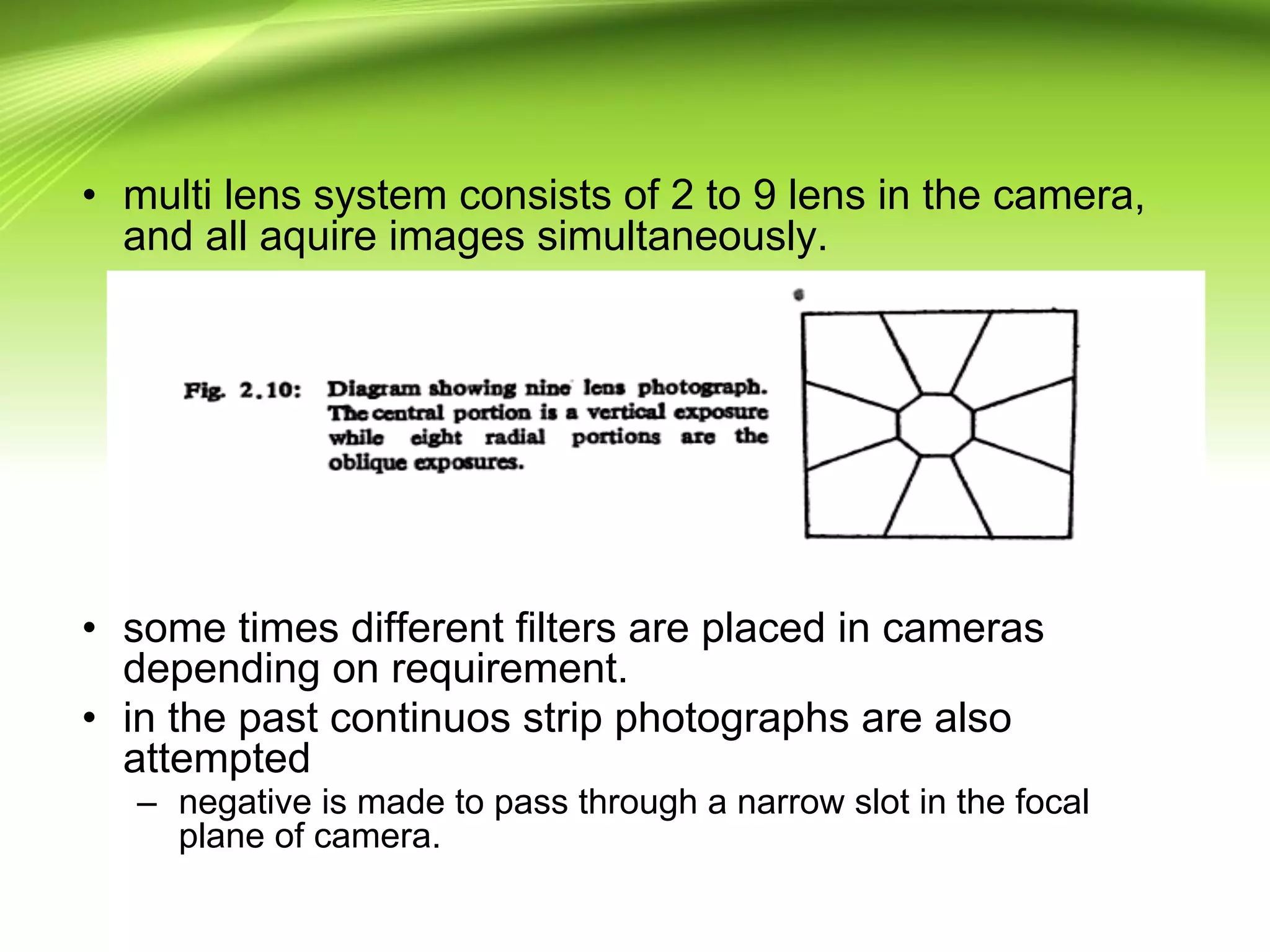
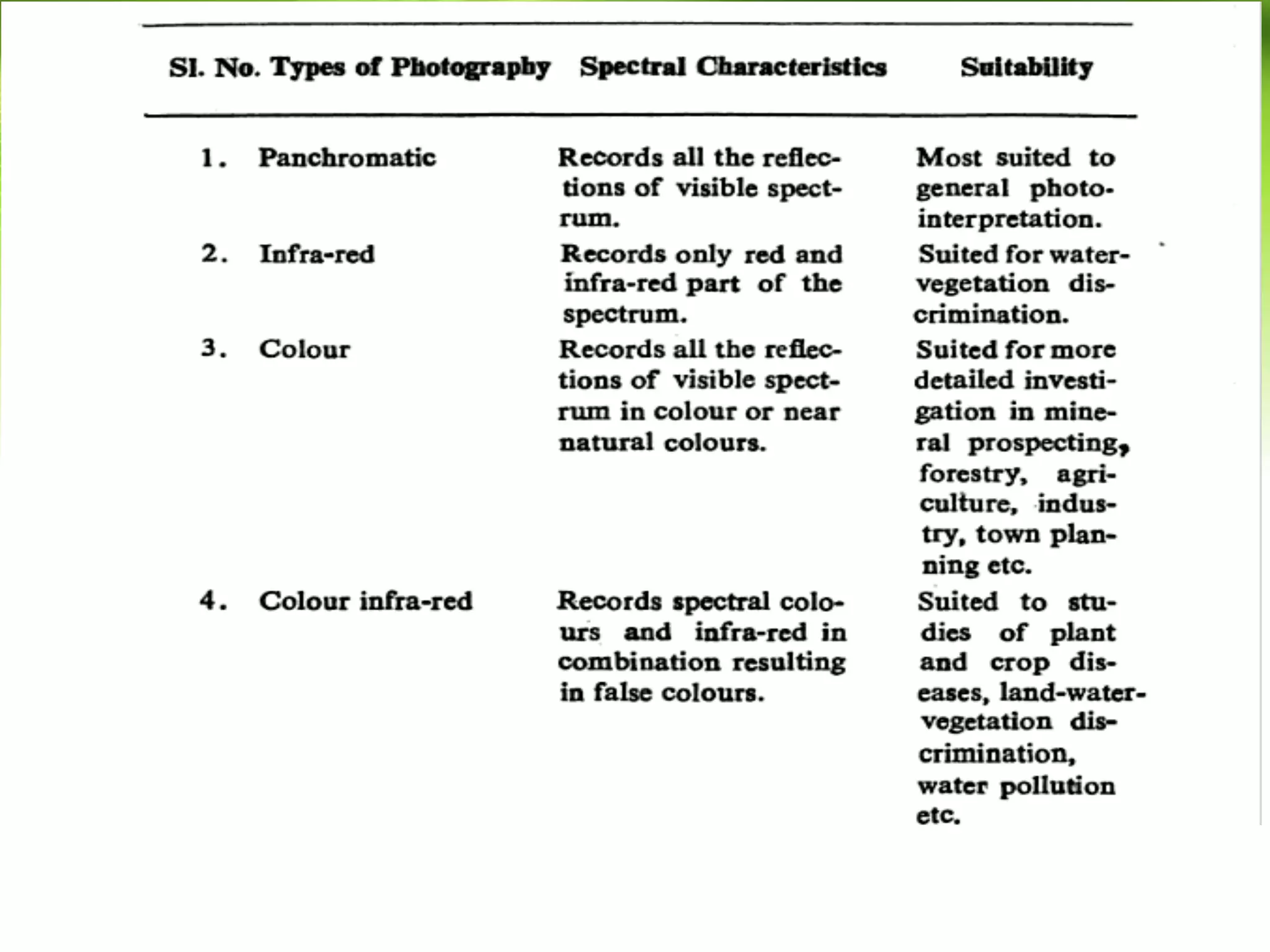
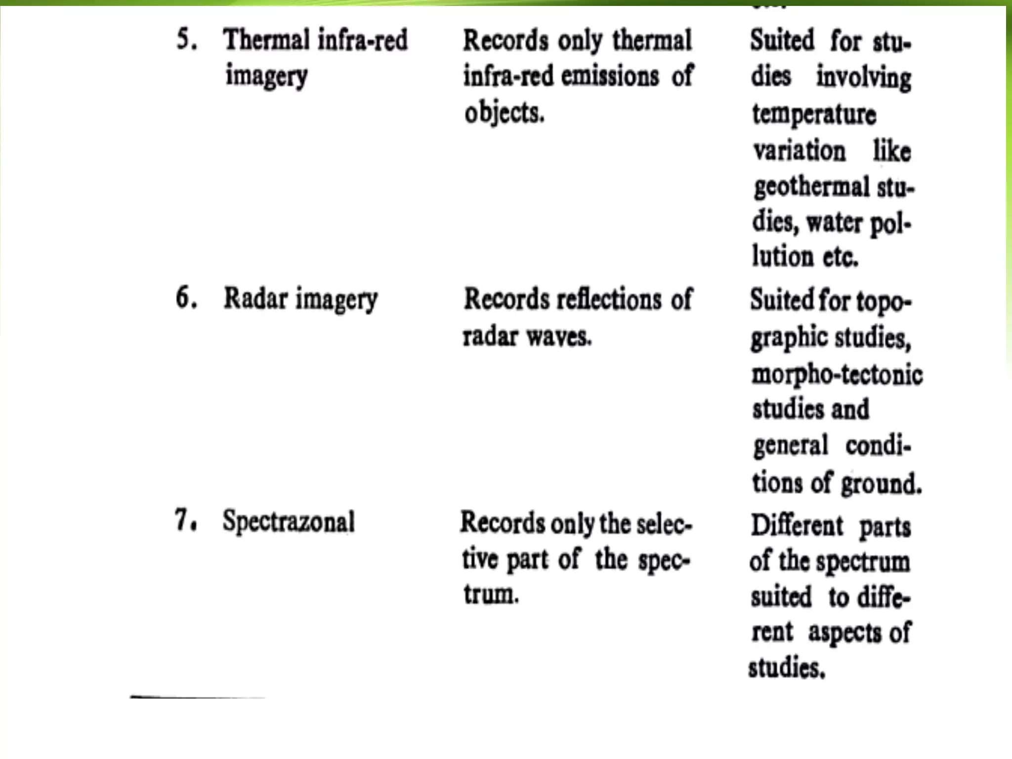
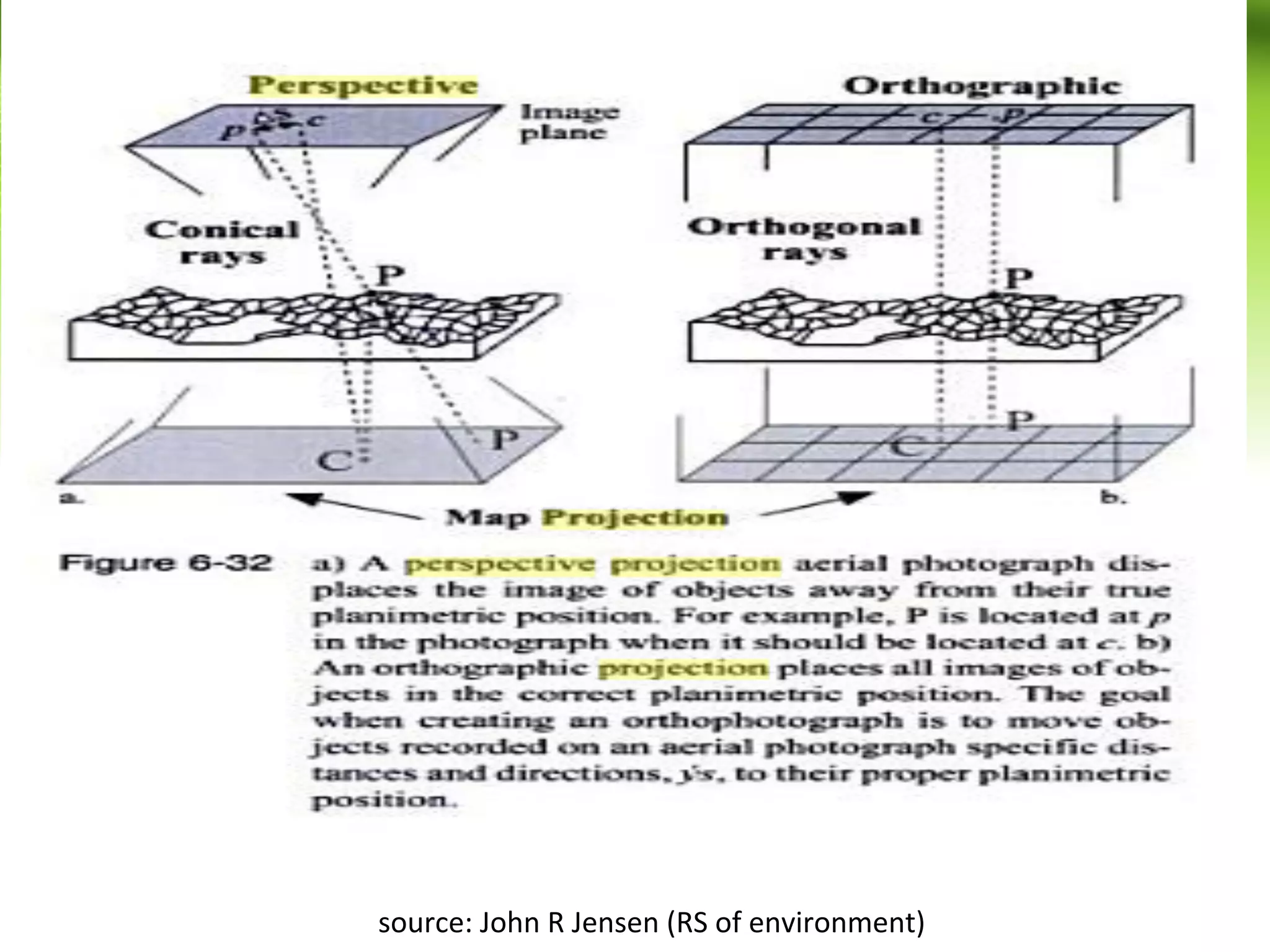
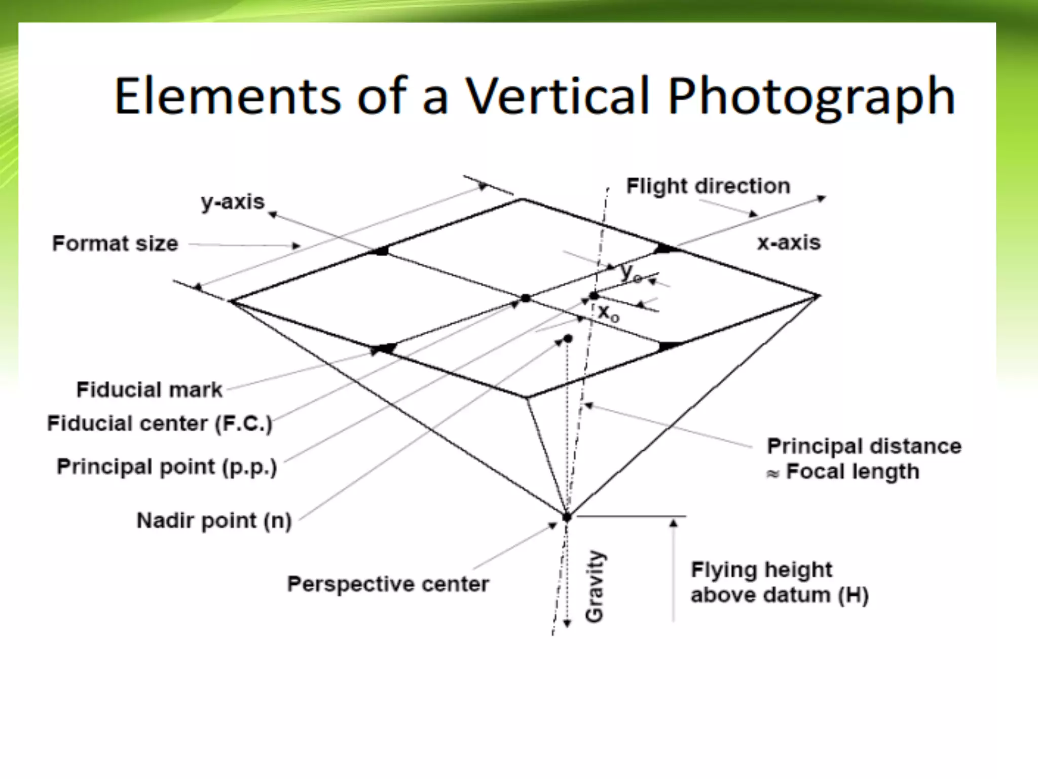
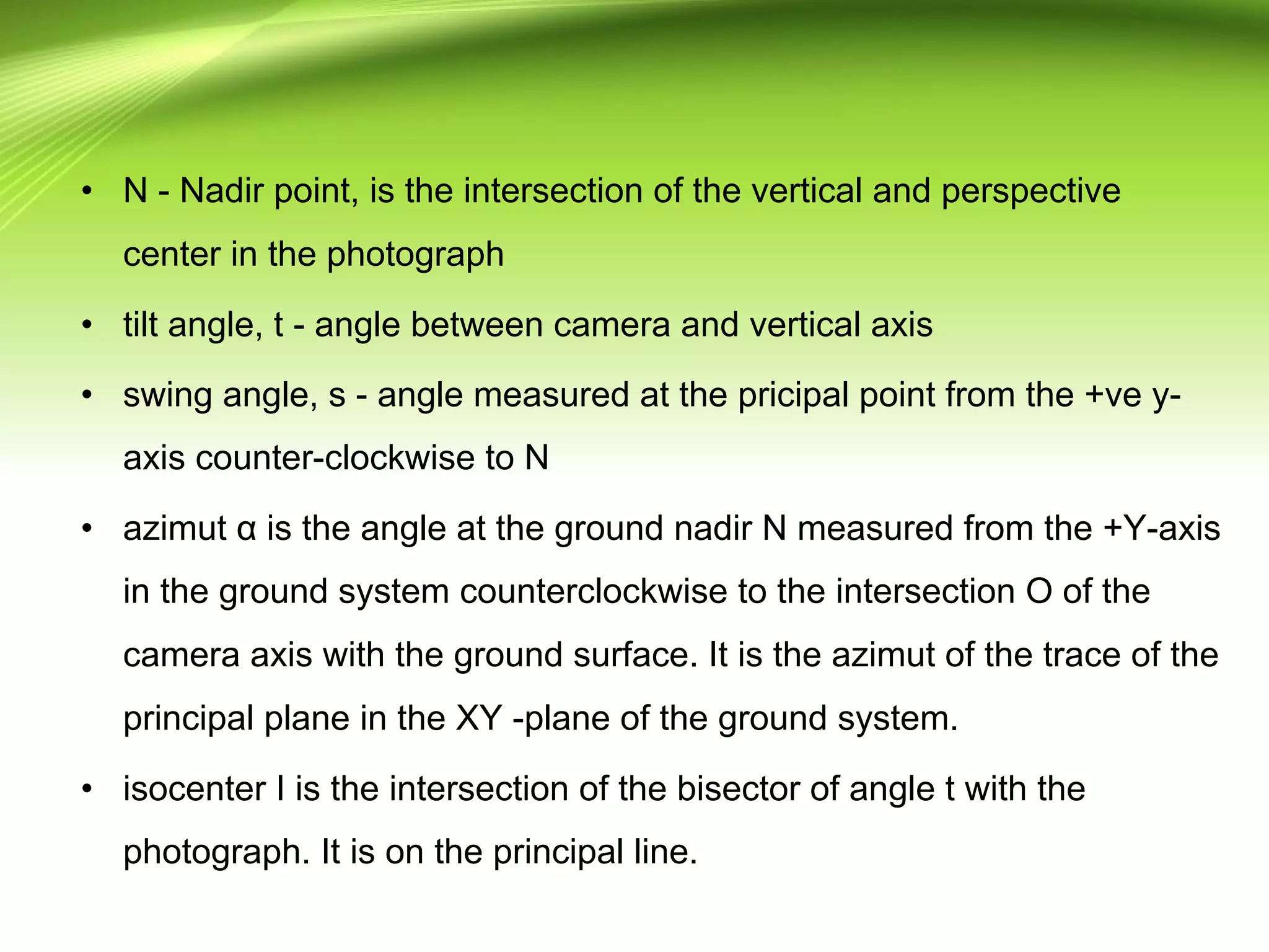
SlideShare a Scribd company logo
Principle of Aerial
Photography
And Types of Photos
By T.SrinivasaRao
Contents
• Introduction -> How it works?(planning, common terms and
formation of photo)
• Types of aerial photographs
• Aerial photo vs Map - 1 point for now
• orthogonal vs perspective projection
• Principle of vertical photograph (dissection of taking aerial
photograph)
• Scale
• Stereoscopy
• Map vs Stereoscopy
• Map vs Mosaic
Introduction
• Aerial photography has been defined as the science of
taking photograph from a point in the air for the purpose
of making some type of study on earth surface.
• The net result of any photographic mission is
photographic negative.
• photographic negatives are the result of favorable and
unfavorable factors acting simultaneously.
• A good aerial photgraph must have a certain standard of
geometrical accuracy.
• Aerial photography and its planning generally includes
selection of types of aeroplane and camera, trend of run,
film and filter combination, which is of great importance
in aerial photo interpretation.
• Most of the conventional aerial photography is done at 1:
30000 to 1:60000 scale on a conventional black and
white panchromatic film.
• The scale of photography further depends on objectives
of the work, which governs the speed of the aircraft and
its flying height, also depends on the type of camera lens
being used.
• optimum scale for geological photo interpretation are 1:
25000 to 1:40000
• For regional geological surveys a small scale photograph
of 1:60000 or even smaller is suitable.
• For extensive ground coverage satellite imagery are
most useful.
• In aerial photography for more specific and detailed
information such as geotechnical studies, mineral
exploration, ground water surveys, land-use planning,
and town planning, large scale photographs on
photographs of scale 1:15000 to 1:10000 are most
suitable.
• In such type aerial photographs, low speed aeroplanes
(200 to 350kmph) are used and flying height is normally
not more than 8000 to 10000m.
• low flying speed and heights are one of the most
important aspects in obtaining sufficiently large scale
photographs with sharp images of objects.
• There should be complete stereographic coverage of
terrain, i.e., all features of the terrain should occur on
atleast 2 photographs for stereoscopic viewing.
• Photographs are taken in runs in the direction of flight in
such a way there will be minimum 60% overlap between
adjacent photos and 30% sidelap between adjacent runs.
• the quality of photographs depends on
– flight and weather conditions
– camera lens
– film and filters
– developing and printing process
• as far as possible photograph should be vertical and
should be free from elements of tilt and tip. Also free from
defects like drift and crab.
• Drift -> 2 Successive flight lines should be parallel in
ideal case.
• At high altitudes because of strong wind currents called
sidewinds influence the aeroplane in maintaining
predetermined direction and straightness of run.
• This deviation from the original intended flight path is
called as drift.
• uncorrected drift will result in subsequent photographs
covering more area in the prevailing wind direction.
• During sidewinds if pilot tries to maintain original path, he
has to turn the nose of the aeroplane slightly against the
wind.
• this makes the aeroplane to rotate on its vertical axis.
• in this case, original path is maintained but the area
covered by photograph is much different than that planned
in the original.
• the aerial photograph is rotated in the direction opposite to
wind direction here.
• This defect is called as crab.
• The above 2 defects causes reduction in stereoscopic
coverage of the terrain.
Types of Aerial Photographs
• Extreme growth in the technology and tecniques used for
acquiring aerial photographs.
• Aerial photographs are classified according to attitude of
camera axis, lens system, types of cameras, types of
films and filters or some special equipment employed in
the camera or techniques to record some special effect
on the film.
• Classification of techniques is done here according to 3
main criteria which are discussed in the next few slides.
Types of Aerial Photographs
• Based on orientation of camera axis
– Vertical photographs
– Low oblique photographs
– High oblique photographs
• Based on lens system
– Single lens photography
– Three lens photography(trimetrogon photography)
– Four lens photography
– Nine lens photography
– Continuos strip photography
Types of Aerial Photographs
• According to special properties of films, filters or
photographic equipment
– Black and white photography (Panachromatic
photography)
– Infra red photography
– Color photography
– Color infra-red photography
– Thermal infra-red photography
– Radar imagery
– Spectrazonal photography
Based on oientation of camera
axis
• aerial photographs are classified according to the
orientation of camera axis at the time of photography.
• Vertical photographs are the ones which are taken with
the axis of camera being vertical at the time of exposure.
• It is virtually impossible to take true vertical photographs.
• Deviation of optical axis from the vertical, if it is in
between 1 to 2 degree, the photographs are called tilted
photographs.
Based on oientation of camera
axis
• Oblique photograph is taken with camera intentionally
tilted from the vertical.
• If horizon is captured in the photograph it is called high
oblique photograph.
• If horizon is not captured in the photograph it is called
low oblique photograph.
According to Lens System
• Single lens system is most commonly used lens system in
most of the aerial photo interpretation work.
• 2, 3 and multi lens became almost obsolete.
• But some of the multi lens techniques are still being used in
war reconnaissance and in photography researches.
• Trimetrogen system of photography is developed to obtain as
much as coverage for the preperation of maps during the
worldwar - II.
– The system got the name as it uses 3 cameras were
assembled with trimetrogen lens
– In this system 2 of the 3 cameras are obliquely
mounted at 60 degree to vertical.
– This will cover photograph upto horizon and some
area in the middle also by the camera which is
mounted vertically.
– all cameras are exposed simultaneously.
– Resulting photographs will cover area from horizon to
horizon in the direction perpendicular to flight line.
– covers more area but scale becomes smaller towards
horizon
– the vertical photgraph has 60% while there is 10 to 30
percent sidelap between vertical and oblique
photographs.
• multi lens system consists of 2 to 9 lens in the camera,
and all aquire images simultaneously.
• some times different filters are placed in cameras
depending on requirement.
• in the past continuos strip photographs are also
attempted
– negative is made to pass through a narrow slot in the focal
plane of camera.
Aerial photo vs Map
• Aerial Photo:
– Central projection
– Non-Uniform scale
– actual features
• Maps
– orthogonal projection
– uniform scale
– symbols
– imaginary objects presence
orthogonal vs perspective
projection
Vertical photograph
vertical photograph - characteristics
• Tilt < 3 degree
• Scale is approximately constant throughout the photo
• Most common format available is 9x9 square inch
• within limitations a vertical photograph can be used to
substitute a map.
• p = i = n for a vertical photograph
( p - principle point, i - isocenter, n - nadir point)
Vertical Aerial Photograph
Tilted photograph
• C - Perspective center
• c - focal length
• principal point - PP
• camera axis - c-PP
• N - Nadir point, is the intersection of the vertical and perspective
center in the photograph
• tilt angle, t - angle between camera and vertical axis
• swing angle, s - angle measured at the pricipal point from the +ve y-
axis counter-clockwise to N
• azimut α is the angle at the ground nadir N measured from the +Y-axis
in the ground system counterclockwise to the intersection O of the
camera axis with the ground surface. It is the azimut of the trace of the
principal plane in the XY -plane of the ground system.
• isocenter I is the intersection of the bisector of angle t with the
photograph. It is on the principal line.
Scale
More discussion on Scale
• Refer your class notes.

More Related Content

What's hot

Remote Sensing Platforms and Its types
Remote Sensing Platforms and Its typesRemote Sensing Platforms and Its types
Remote Sensing Platforms and Its typesSenthamizhan M
 
Aerial photography- Concept and Terminologies
Aerial photography- Concept and Terminologies Aerial photography- Concept and Terminologies
Aerial photography- Concept and Terminologies UTTIYACHATTOPADHYAY2
 
Chapter 5: Remote sensing
Chapter 5: Remote sensingChapter 5: Remote sensing
Chapter 5: Remote sensingShankar Gangaju
 
Introduction to Landsat
Introduction to LandsatIntroduction to Landsat
Introduction to LandsatNizam GIS
 
Remote sensing - Sensors, Platforms and Satellite orbits
Remote sensing - Sensors, Platforms and Satellite orbitsRemote sensing - Sensors, Platforms and Satellite orbits
Remote sensing - Sensors, Platforms and Satellite orbitsAjay Singh Lodhi
 
Sensors for remote sensing
Sensors for remote sensingSensors for remote sensing
Sensors for remote sensingMohsin Siddique
 
Aerial photographs and their interpretation
Aerial photographs and their interpretationAerial photographs and their interpretation
Aerial photographs and their interpretationSumant Diwakar
 
Advantages and disadvantages of Remote Sensing
Advantages and disadvantages of Remote SensingAdvantages and disadvantages of Remote Sensing
Advantages and disadvantages of Remote SensingEr Abhi Vashi
 
Introduction and Application of GIS
Introduction and Application of GISIntroduction and Application of GIS
Introduction and Application of GISSatish Taji
 
Chapter 1 (Introduction to remote sensing)
Chapter 1 (Introduction to remote sensing)Chapter 1 (Introduction to remote sensing)
Chapter 1 (Introduction to remote sensing)Shankar Gangaju
 
Remote sensing ppt
Remote sensing pptRemote sensing ppt
Remote sensing pptcoolmridul92
 
Remote Sensing and its Application
Remote Sensing and its ApplicationRemote Sensing and its Application
Remote Sensing and its ApplicationRashmi Yadav
 
Remote sensing - Scanners
Remote sensing - ScannersRemote sensing - Scanners
Remote sensing - ScannersPramoda Raj
 
Digital image processing
Digital image processingDigital image processing
Digital image processingVandana Verma
 
Projections and coordinate system
Projections and coordinate systemProjections and coordinate system
Projections and coordinate systemMohsin Siddique
 
Thermal remote sensing
Thermal remote sensing   Thermal remote sensing
Thermal remote sensing Rahat Malik
 
Types of scanners
Types of scannersTypes of scanners
Types of scannersPramoda Raj
 

What's hot (20)

Digital elevation model in GIS
Digital elevation model in GISDigital elevation model in GIS
Digital elevation model in GIS
 
Remote Sensing Platforms and Its types
Remote Sensing Platforms and Its typesRemote Sensing Platforms and Its types
Remote Sensing Platforms and Its types
 
Aerial photography- Concept and Terminologies
Aerial photography- Concept and Terminologies Aerial photography- Concept and Terminologies
Aerial photography- Concept and Terminologies
 
Chapter 5: Remote sensing
Chapter 5: Remote sensingChapter 5: Remote sensing
Chapter 5: Remote sensing
 
Introduction to Landsat
Introduction to LandsatIntroduction to Landsat
Introduction to Landsat
 
Remote sensing - Sensors, Platforms and Satellite orbits
Remote sensing - Sensors, Platforms and Satellite orbitsRemote sensing - Sensors, Platforms and Satellite orbits
Remote sensing - Sensors, Platforms and Satellite orbits
 
Digital Elevation Model (DEM)
Digital Elevation Model (DEM)Digital Elevation Model (DEM)
Digital Elevation Model (DEM)
 
Sensors for remote sensing
Sensors for remote sensingSensors for remote sensing
Sensors for remote sensing
 
Aerial photographs and their interpretation
Aerial photographs and their interpretationAerial photographs and their interpretation
Aerial photographs and their interpretation
 
Advantages and disadvantages of Remote Sensing
Advantages and disadvantages of Remote SensingAdvantages and disadvantages of Remote Sensing
Advantages and disadvantages of Remote Sensing
 
Introduction and Application of GIS
Introduction and Application of GISIntroduction and Application of GIS
Introduction and Application of GIS
 
Chapter 1 (Introduction to remote sensing)
Chapter 1 (Introduction to remote sensing)Chapter 1 (Introduction to remote sensing)
Chapter 1 (Introduction to remote sensing)
 
Remote sensing ppt
Remote sensing pptRemote sensing ppt
Remote sensing ppt
 
Remote Sensing and its Application
Remote Sensing and its ApplicationRemote Sensing and its Application
Remote Sensing and its Application
 
Remote sensing - Scanners
Remote sensing - ScannersRemote sensing - Scanners
Remote sensing - Scanners
 
Digital image processing
Digital image processingDigital image processing
Digital image processing
 
Projections and coordinate system
Projections and coordinate systemProjections and coordinate system
Projections and coordinate system
 
Map projection
Map projection Map projection
Map projection
 
Thermal remote sensing
Thermal remote sensing   Thermal remote sensing
Thermal remote sensing
 
Types of scanners
Types of scannersTypes of scanners
Types of scanners
 

Viewers also liked

Photogrammetry- Surveying
Photogrammetry- SurveyingPhotogrammetry- Surveying
Photogrammetry- SurveyingGokul Saud
 
BASIC CONCEPTS OF PHOTOGRAMMETRY
BASIC CONCEPTS OF PHOTOGRAMMETRYBASIC CONCEPTS OF PHOTOGRAMMETRY
BASIC CONCEPTS OF PHOTOGRAMMETRYNamitha M R
 
Aerial photography abraham thomas
Aerial photography abraham thomasAerial photography abraham thomas
Aerial photography abraham thomasSumant Diwakar
 
Principles of remote sensing
Principles of remote sensingPrinciples of remote sensing
Principles of remote sensingPramoda Raj
 
Remote sensing & Gis
Remote sensing & GisRemote sensing & Gis
Remote sensing & Gisgopichand's
 
Lecture on photogrammetry
Lecture on photogrammetryLecture on photogrammetry
Lecture on photogrammetryWaleed Liaqat
 
Lecture 1-aerial photogrammetry
Lecture 1-aerial photogrammetryLecture 1-aerial photogrammetry
Lecture 1-aerial photogrammetryVidhi Khokhani
 
Urban Landuse/ Landcover change analysis using Remote Sensing and GIS
Urban Landuse/ Landcover change analysis using Remote Sensing and GISUrban Landuse/ Landcover change analysis using Remote Sensing and GIS
Urban Landuse/ Landcover change analysis using Remote Sensing and GISHarshvardhan Vashistha
 
Spatial vs non spatial
Spatial vs non spatialSpatial vs non spatial
Spatial vs non spatialSumant Diwakar
 
Robots presentation
Robots presentationRobots presentation
Robots presentationaroobkazim
 
Robot PowerPoint
Robot PowerPointRobot PowerPoint
Robot PowerPointbradschultz
 

Viewers also liked (14)

Photogrammetry- Surveying
Photogrammetry- SurveyingPhotogrammetry- Surveying
Photogrammetry- Surveying
 
BASIC CONCEPTS OF PHOTOGRAMMETRY
BASIC CONCEPTS OF PHOTOGRAMMETRYBASIC CONCEPTS OF PHOTOGRAMMETRY
BASIC CONCEPTS OF PHOTOGRAMMETRY
 
Aerial photography abraham thomas
Aerial photography abraham thomasAerial photography abraham thomas
Aerial photography abraham thomas
 
Principles of remote sensing
Principles of remote sensingPrinciples of remote sensing
Principles of remote sensing
 
Remote sensing & Gis
Remote sensing & GisRemote sensing & Gis
Remote sensing & Gis
 
Remote sensing
Remote sensingRemote sensing
Remote sensing
 
Lecture on photogrammetry
Lecture on photogrammetryLecture on photogrammetry
Lecture on photogrammetry
 
Lecture 1-aerial photogrammetry
Lecture 1-aerial photogrammetryLecture 1-aerial photogrammetry
Lecture 1-aerial photogrammetry
 
Urban Landuse/ Landcover change analysis using Remote Sensing and GIS
Urban Landuse/ Landcover change analysis using Remote Sensing and GISUrban Landuse/ Landcover change analysis using Remote Sensing and GIS
Urban Landuse/ Landcover change analysis using Remote Sensing and GIS
 
Spatial vs non spatial
Spatial vs non spatialSpatial vs non spatial
Spatial vs non spatial
 
Robots presentation
Robots presentationRobots presentation
Robots presentation
 
Robot PowerPoint
Robot PowerPointRobot PowerPoint
Robot PowerPoint
 
GIS data structure
GIS data structureGIS data structure
GIS data structure
 
robotics ppt
robotics ppt robotics ppt
robotics ppt
 

Similar to Principle of aerial photography and types.ppt

PHOTOGRAMMETIC SURVEYING
PHOTOGRAMMETIC SURVEYING PHOTOGRAMMETIC SURVEYING
PHOTOGRAMMETIC SURVEYING ADCET, Ashta
 
REMOTE SENSING_TOPIC_II_2023.pptx
REMOTE SENSING_TOPIC_II_2023.pptxREMOTE SENSING_TOPIC_II_2023.pptx
REMOTE SENSING_TOPIC_II_2023.pptxarmanisingh31
 
aerialphotography-220920130348-1b827bf0.pdf
aerialphotography-220920130348-1b827bf0.pdfaerialphotography-220920130348-1b827bf0.pdf
aerialphotography-220920130348-1b827bf0.pdfpritamaitch
 
Photogrammetry for civil engineering,land survey
Photogrammetry for civil engineering,land surveyPhotogrammetry for civil engineering,land survey
Photogrammetry for civil engineering,land surveymartinmutwiri875
 
Photogrammetry.pdf
Photogrammetry.pdfPhotogrammetry.pdf
Photogrammetry.pdfBSuresh26
 
Geometry of Aerial Photographs.pdf
Geometry of Aerial Photographs.pdfGeometry of Aerial Photographs.pdf
Geometry of Aerial Photographs.pdfkunedzimwefrancisca
 
Aerial Photogrammetry
Aerial Photogrammetry Aerial Photogrammetry
Aerial Photogrammetry Mujeeb Muji
 
SURVEYING - Photogrammetry (CE 115) Lec2 By Afia Narzis Spring 2016
SURVEYING - Photogrammetry (CE 115) Lec2 By Afia Narzis Spring 2016SURVEYING - Photogrammetry (CE 115) Lec2 By Afia Narzis Spring 2016
SURVEYING - Photogrammetry (CE 115) Lec2 By Afia Narzis Spring 2016PIYAL Bhuiyan
 
01 introdcution to photogrammetry
01 introdcution to photogrammetry01 introdcution to photogrammetry
01 introdcution to photogrammetrySarhat Adam
 
03 cameras &amp; their geometry
03 cameras &amp; their geometry03 cameras &amp; their geometry
03 cameras &amp; their geometrySarhat Adam
 
Photographic surveying
Photographic surveyingPhotographic surveying
Photographic surveyingHUSSAINGHAZI1
 
Surveying ii module iii class 1,2
Surveying ii module iii class 1,2Surveying ii module iii class 1,2
Surveying ii module iii class 1,2SHAMJITH KM
 
Aerial Photogrammetry 01
Aerial Photogrammetry 01Aerial Photogrammetry 01
Aerial Photogrammetry 01Rajesh Rajguru
 
Geometry and Projection of Aerial Photograph
Geometry and Projection of Aerial PhotographGeometry and Projection of Aerial Photograph
Geometry and Projection of Aerial PhotographShavnamMehta
 

Similar to Principle of aerial photography and types.ppt (20)

PHOTOGRAMMETIC SURVEYING
PHOTOGRAMMETIC SURVEYING PHOTOGRAMMETIC SURVEYING
PHOTOGRAMMETIC SURVEYING
 
REMOTE SENSING_TOPIC_II_2023.pptx
REMOTE SENSING_TOPIC_II_2023.pptxREMOTE SENSING_TOPIC_II_2023.pptx
REMOTE SENSING_TOPIC_II_2023.pptx
 
aerialphotography-220920130348-1b827bf0.pdf
aerialphotography-220920130348-1b827bf0.pdfaerialphotography-220920130348-1b827bf0.pdf
aerialphotography-220920130348-1b827bf0.pdf
 
Photogrammetry-part 1
Photogrammetry-part 1Photogrammetry-part 1
Photogrammetry-part 1
 
Photogrammetry for civil engineering,land survey
Photogrammetry for civil engineering,land surveyPhotogrammetry for civil engineering,land survey
Photogrammetry for civil engineering,land survey
 
Introduction of photogrammetry
Introduction of photogrammetryIntroduction of photogrammetry
Introduction of photogrammetry
 
Aerial Photography.pptx
Aerial Photography.pptxAerial Photography.pptx
Aerial Photography.pptx
 
Photogrammetry.pdf
Photogrammetry.pdfPhotogrammetry.pdf
Photogrammetry.pdf
 
Geometry of Aerial Photographs.pdf
Geometry of Aerial Photographs.pdfGeometry of Aerial Photographs.pdf
Geometry of Aerial Photographs.pdf
 
Aerial Photogrammetry
Aerial Photogrammetry Aerial Photogrammetry
Aerial Photogrammetry
 
PHOTOGRAMETRY SURVEY
PHOTOGRAMETRY SURVEYPHOTOGRAMETRY SURVEY
PHOTOGRAMETRY SURVEY
 
SURVEYING - Photogrammetry (CE 115) Lec2 By Afia Narzis Spring 2016
SURVEYING - Photogrammetry (CE 115) Lec2 By Afia Narzis Spring 2016SURVEYING - Photogrammetry (CE 115) Lec2 By Afia Narzis Spring 2016
SURVEYING - Photogrammetry (CE 115) Lec2 By Afia Narzis Spring 2016
 
PHOTOGRAMMETRY.pptx
PHOTOGRAMMETRY.pptxPHOTOGRAMMETRY.pptx
PHOTOGRAMMETRY.pptx
 
01 introdcution to photogrammetry
01 introdcution to photogrammetry01 introdcution to photogrammetry
01 introdcution to photogrammetry
 
03 cameras &amp; their geometry
03 cameras &amp; their geometry03 cameras &amp; their geometry
03 cameras &amp; their geometry
 
Photographic surveying
Photographic surveyingPhotographic surveying
Photographic surveying
 
Surveying ii module iii class 1,2
Surveying ii module iii class 1,2Surveying ii module iii class 1,2
Surveying ii module iii class 1,2
 
Aerial Photogrammetry 01
Aerial Photogrammetry 01Aerial Photogrammetry 01
Aerial Photogrammetry 01
 
Photogrammetry amir
Photogrammetry amirPhotogrammetry amir
Photogrammetry amir
 
Geometry and Projection of Aerial Photograph
Geometry and Projection of Aerial PhotographGeometry and Projection of Aerial Photograph
Geometry and Projection of Aerial Photograph
 

More from srinivas2036

Fundamental operations
Fundamental operationsFundamental operations
Fundamental operationssrinivas2036
 
Data collection and input overview
Data collection and input overviewData collection and input overview
Data collection and input overviewsrinivas2036
 
Theoretical framework for gis
Theoretical framework for gisTheoretical framework for gis
Theoretical framework for gissrinivas2036
 
Construction planning - Construction Technology and Project Management
Construction planning - Construction Technology and Project ManagementConstruction planning - Construction Technology and Project Management
Construction planning - Construction Technology and Project Managementsrinivas2036
 
Mechanized construction
Mechanized constructionMechanized construction
Mechanized constructionsrinivas2036
 
Construction claims, disputes and project closure
Construction claims, disputes and project closureConstruction claims, disputes and project closure
Construction claims, disputes and project closuresrinivas2036
 
Fire protection in construction
Fire protection in constructionFire protection in construction
Fire protection in constructionsrinivas2036
 
Environment at site – construction management
Environment at site – construction managementEnvironment at site – construction management
Environment at site – construction managementsrinivas2036
 
Electrical safety in construction
Electrical safety in constructionElectrical safety in construction
Electrical safety in constructionsrinivas2036
 
Personal safety in construction
Personal safety in constructionPersonal safety in construction
Personal safety in constructionsrinivas2036
 
Startup india action plan – who are eligible
Startup india action plan – who are eligibleStartup india action plan – who are eligible
Startup india action plan – who are eligiblesrinivas2036
 
Topic stereoscopy, Parallax, Relief displacement
Topic  stereoscopy, Parallax, Relief displacementTopic  stereoscopy, Parallax, Relief displacement
Topic stereoscopy, Parallax, Relief displacementsrinivas2036
 
GATE Syllabus Civil engineering
GATE Syllabus Civil engineeringGATE Syllabus Civil engineering
GATE Syllabus Civil engineeringsrinivas2036
 
Estimation and Costing - Contracts
Estimation and Costing - ContractsEstimation and Costing - Contracts
Estimation and Costing - Contractssrinivas2036
 
Airport apron and holding bays
Airport apron and holding baysAirport apron and holding bays
Airport apron and holding bayssrinivas2036
 
Pavement Materials Bitumen
Pavement Materials  BitumenPavement Materials  Bitumen
Pavement Materials Bitumensrinivas2036
 

More from srinivas2036 (20)

Fundamental operations
Fundamental operationsFundamental operations
Fundamental operations
 
Data collection and input overview
Data collection and input overviewData collection and input overview
Data collection and input overview
 
Theoretical framework for gis
Theoretical framework for gisTheoretical framework for gis
Theoretical framework for gis
 
Construction planning - Construction Technology and Project Management
Construction planning - Construction Technology and Project ManagementConstruction planning - Construction Technology and Project Management
Construction planning - Construction Technology and Project Management
 
Mechanized construction
Mechanized constructionMechanized construction
Mechanized construction
 
Construction claims, disputes and project closure
Construction claims, disputes and project closureConstruction claims, disputes and project closure
Construction claims, disputes and project closure
 
Fire protection in construction
Fire protection in constructionFire protection in construction
Fire protection in construction
 
Environment at site – construction management
Environment at site – construction managementEnvironment at site – construction management
Environment at site – construction management
 
Electrical safety in construction
Electrical safety in constructionElectrical safety in construction
Electrical safety in construction
 
Personal safety in construction
Personal safety in constructionPersonal safety in construction
Personal safety in construction
 
Startup india action plan – who are eligible
Startup india action plan – who are eligibleStartup india action plan – who are eligible
Startup india action plan – who are eligible
 
Topic stereoscopy, Parallax, Relief displacement
Topic  stereoscopy, Parallax, Relief displacementTopic  stereoscopy, Parallax, Relief displacement
Topic stereoscopy, Parallax, Relief displacement
 
GATE Syllabus Civil engineering
GATE Syllabus Civil engineeringGATE Syllabus Civil engineering
GATE Syllabus Civil engineering
 
Estimation and Costing - Contracts
Estimation and Costing - ContractsEstimation and Costing - Contracts
Estimation and Costing - Contracts
 
Valuation
ValuationValuation
Valuation
 
Airport lighting
Airport lightingAirport lighting
Airport lighting
 
Airport marking
Airport markingAirport marking
Airport marking
 
Airport apron and holding bays
Airport apron and holding baysAirport apron and holding bays
Airport apron and holding bays
 
Pavement Materials Bitumen
Pavement Materials  BitumenPavement Materials  Bitumen
Pavement Materials Bitumen
 
Hangars
HangarsHangars
Hangars
 

Recently uploaded

Sha'Carri Richardson Presentation 202345
Sha'Carri Richardson Presentation 202345Sha'Carri Richardson Presentation 202345
Sha'Carri Richardson Presentation 202345beazzy04
 
2024_Student Session 2_ Set Plan Preparation.pptx
2024_Student Session 2_ Set Plan Preparation.pptx2024_Student Session 2_ Set Plan Preparation.pptx
2024_Student Session 2_ Set Plan Preparation.pptxmansk2
 
The Art Pastor's Guide to Sabbath | Steve Thomason
The Art Pastor's Guide to Sabbath | Steve ThomasonThe Art Pastor's Guide to Sabbath | Steve Thomason
The Art Pastor's Guide to Sabbath | Steve ThomasonSteve Thomason
 
How to Manage Notification Preferences in the Odoo 17
How to Manage Notification Preferences in the Odoo 17How to Manage Notification Preferences in the Odoo 17
How to Manage Notification Preferences in the Odoo 17Celine George
 
aaaaaaaaaaaaaaaaaaaaaaaaaaaaaaaaaaaaaaaaaaaaaaaaaaaaaaa
aaaaaaaaaaaaaaaaaaaaaaaaaaaaaaaaaaaaaaaaaaaaaaaaaaaaaaaaaaaaaaaaaaaaaaaaaaaaaaaaaaaaaaaaaaaaaaaaaaaaaaaaaaaaaa
aaaaaaaaaaaaaaaaaaaaaaaaaaaaaaaaaaaaaaaaaaaaaaaaaaaaaaasiemaillard
 
INU_CAPSTONEDESIGN_비밀번호486_업로드용 발표자료.pdf
INU_CAPSTONEDESIGN_비밀번호486_업로드용 발표자료.pdfINU_CAPSTONEDESIGN_비밀번호486_업로드용 발표자료.pdf
INU_CAPSTONEDESIGN_비밀번호486_업로드용 발표자료.pdfbu07226
 
The Benefits and Challenges of Open Educational Resources
The Benefits and Challenges of Open Educational ResourcesThe Benefits and Challenges of Open Educational Resources
The Benefits and Challenges of Open Educational Resourcesaileywriter
 
Basic Civil Engineering Notes of Chapter-6, Topic- Ecosystem, Biodiversity G...
Basic Civil Engineering Notes of Chapter-6,  Topic- Ecosystem, Biodiversity G...Basic Civil Engineering Notes of Chapter-6,  Topic- Ecosystem, Biodiversity G...
Basic Civil Engineering Notes of Chapter-6, Topic- Ecosystem, Biodiversity G...Denish Jangid
 
GIÁO ÁN DẠY THÊM (KẾ HOẠCH BÀI BUỔI 2) - TIẾNG ANH 8 GLOBAL SUCCESS (2 CỘT) N...
GIÁO ÁN DẠY THÊM (KẾ HOẠCH BÀI BUỔI 2) - TIẾNG ANH 8 GLOBAL SUCCESS (2 CỘT) N...GIÁO ÁN DẠY THÊM (KẾ HOẠCH BÀI BUỔI 2) - TIẾNG ANH 8 GLOBAL SUCCESS (2 CỘT) N...
GIÁO ÁN DẠY THÊM (KẾ HOẠCH BÀI BUỔI 2) - TIẾNG ANH 8 GLOBAL SUCCESS (2 CỘT) N...Nguyen Thanh Tu Collection
 
Research Methods in Psychology | Cambridge AS Level | Cambridge Assessment In...
Research Methods in Psychology | Cambridge AS Level | Cambridge Assessment In...Research Methods in Psychology | Cambridge AS Level | Cambridge Assessment In...
Research Methods in Psychology | Cambridge AS Level | Cambridge Assessment In...Abhinav Gaur Kaptaan
 
PART A. Introduction to Costumer Service
PART A. Introduction to Costumer ServicePART A. Introduction to Costumer Service
PART A. Introduction to Costumer ServicePedroFerreira53928
 
How to Break the cycle of negative Thoughts
How to Break the cycle of negative ThoughtsHow to Break the cycle of negative Thoughts
How to Break the cycle of negative ThoughtsCol Mukteshwar Prasad
 
Benefits and Challenges of Using Open Educational Resources
Benefits and Challenges of Using Open Educational ResourcesBenefits and Challenges of Using Open Educational Resources
Benefits and Challenges of Using Open Educational Resourcesdimpy50
 
Pragya Champions Chalice 2024 Prelims & Finals Q/A set, General Quiz
Pragya Champions Chalice 2024 Prelims & Finals Q/A set, General QuizPragya Champions Chalice 2024 Prelims & Finals Q/A set, General Quiz
Pragya Champions Chalice 2024 Prelims & Finals Q/A set, General QuizPragya - UEM Kolkata Quiz Club
 
Application of Matrices in real life. Presentation on application of matrices
Application of Matrices in real life. Presentation on application of matricesApplication of Matrices in real life. Presentation on application of matrices
Application of Matrices in real life. Presentation on application of matricesRased Khan
 
Phrasal Verbs.XXXXXXXXXXXXXXXXXXXXXXXXXX
Phrasal Verbs.XXXXXXXXXXXXXXXXXXXXXXXXXXPhrasal Verbs.XXXXXXXXXXXXXXXXXXXXXXXXXX
Phrasal Verbs.XXXXXXXXXXXXXXXXXXXXXXXXXXMIRIAMSALINAS13
 
MARUTI SUZUKI- A Successful Joint Venture in India.pptx
MARUTI SUZUKI- A Successful Joint Venture in India.pptxMARUTI SUZUKI- A Successful Joint Venture in India.pptx
MARUTI SUZUKI- A Successful Joint Venture in India.pptxbennyroshan06
 
Basic Civil Engg Notes_Chapter-6_Environment Pollution & Engineering
Basic Civil Engg Notes_Chapter-6_Environment Pollution & EngineeringBasic Civil Engg Notes_Chapter-6_Environment Pollution & Engineering
Basic Civil Engg Notes_Chapter-6_Environment Pollution & EngineeringDenish Jangid
 

Recently uploaded (20)

Sha'Carri Richardson Presentation 202345
Sha'Carri Richardson Presentation 202345Sha'Carri Richardson Presentation 202345
Sha'Carri Richardson Presentation 202345
 
2024_Student Session 2_ Set Plan Preparation.pptx
2024_Student Session 2_ Set Plan Preparation.pptx2024_Student Session 2_ Set Plan Preparation.pptx
2024_Student Session 2_ Set Plan Preparation.pptx
 
The Art Pastor's Guide to Sabbath | Steve Thomason
The Art Pastor's Guide to Sabbath | Steve ThomasonThe Art Pastor's Guide to Sabbath | Steve Thomason
The Art Pastor's Guide to Sabbath | Steve Thomason
 
How to Manage Notification Preferences in the Odoo 17
How to Manage Notification Preferences in the Odoo 17How to Manage Notification Preferences in the Odoo 17
How to Manage Notification Preferences in the Odoo 17
 
aaaaaaaaaaaaaaaaaaaaaaaaaaaaaaaaaaaaaaaaaaaaaaaaaaaaaaa
aaaaaaaaaaaaaaaaaaaaaaaaaaaaaaaaaaaaaaaaaaaaaaaaaaaaaaaaaaaaaaaaaaaaaaaaaaaaaaaaaaaaaaaaaaaaaaaaaaaaaaaaaaaaaa
aaaaaaaaaaaaaaaaaaaaaaaaaaaaaaaaaaaaaaaaaaaaaaaaaaaaaaa
 
Operations Management - Book1.p - Dr. Abdulfatah A. Salem
Operations Management - Book1.p  - Dr. Abdulfatah A. SalemOperations Management - Book1.p  - Dr. Abdulfatah A. Salem
Operations Management - Book1.p - Dr. Abdulfatah A. Salem
 
INU_CAPSTONEDESIGN_비밀번호486_업로드용 발표자료.pdf
INU_CAPSTONEDESIGN_비밀번호486_업로드용 발표자료.pdfINU_CAPSTONEDESIGN_비밀번호486_업로드용 발표자료.pdf
INU_CAPSTONEDESIGN_비밀번호486_업로드용 발표자료.pdf
 
The Benefits and Challenges of Open Educational Resources
The Benefits and Challenges of Open Educational ResourcesThe Benefits and Challenges of Open Educational Resources
The Benefits and Challenges of Open Educational Resources
 
B.ed spl. HI pdusu exam paper-2023-24.pdf
B.ed spl. HI pdusu exam paper-2023-24.pdfB.ed spl. HI pdusu exam paper-2023-24.pdf
B.ed spl. HI pdusu exam paper-2023-24.pdf
 
Basic Civil Engineering Notes of Chapter-6, Topic- Ecosystem, Biodiversity G...
Basic Civil Engineering Notes of Chapter-6,  Topic- Ecosystem, Biodiversity G...Basic Civil Engineering Notes of Chapter-6,  Topic- Ecosystem, Biodiversity G...
Basic Civil Engineering Notes of Chapter-6, Topic- Ecosystem, Biodiversity G...
 
GIÁO ÁN DẠY THÊM (KẾ HOẠCH BÀI BUỔI 2) - TIẾNG ANH 8 GLOBAL SUCCESS (2 CỘT) N...
GIÁO ÁN DẠY THÊM (KẾ HOẠCH BÀI BUỔI 2) - TIẾNG ANH 8 GLOBAL SUCCESS (2 CỘT) N...GIÁO ÁN DẠY THÊM (KẾ HOẠCH BÀI BUỔI 2) - TIẾNG ANH 8 GLOBAL SUCCESS (2 CỘT) N...
GIÁO ÁN DẠY THÊM (KẾ HOẠCH BÀI BUỔI 2) - TIẾNG ANH 8 GLOBAL SUCCESS (2 CỘT) N...
 
Research Methods in Psychology | Cambridge AS Level | Cambridge Assessment In...
Research Methods in Psychology | Cambridge AS Level | Cambridge Assessment In...Research Methods in Psychology | Cambridge AS Level | Cambridge Assessment In...
Research Methods in Psychology | Cambridge AS Level | Cambridge Assessment In...
 
PART A. Introduction to Costumer Service
PART A. Introduction to Costumer ServicePART A. Introduction to Costumer Service
PART A. Introduction to Costumer Service
 
How to Break the cycle of negative Thoughts
How to Break the cycle of negative ThoughtsHow to Break the cycle of negative Thoughts
How to Break the cycle of negative Thoughts
 
Benefits and Challenges of Using Open Educational Resources
Benefits and Challenges of Using Open Educational ResourcesBenefits and Challenges of Using Open Educational Resources
Benefits and Challenges of Using Open Educational Resources
 
Pragya Champions Chalice 2024 Prelims & Finals Q/A set, General Quiz
Pragya Champions Chalice 2024 Prelims & Finals Q/A set, General QuizPragya Champions Chalice 2024 Prelims & Finals Q/A set, General Quiz
Pragya Champions Chalice 2024 Prelims & Finals Q/A set, General Quiz
 
Application of Matrices in real life. Presentation on application of matrices
Application of Matrices in real life. Presentation on application of matricesApplication of Matrices in real life. Presentation on application of matrices
Application of Matrices in real life. Presentation on application of matrices
 
Phrasal Verbs.XXXXXXXXXXXXXXXXXXXXXXXXXX
Phrasal Verbs.XXXXXXXXXXXXXXXXXXXXXXXXXXPhrasal Verbs.XXXXXXXXXXXXXXXXXXXXXXXXXX
Phrasal Verbs.XXXXXXXXXXXXXXXXXXXXXXXXXX
 
MARUTI SUZUKI- A Successful Joint Venture in India.pptx
MARUTI SUZUKI- A Successful Joint Venture in India.pptxMARUTI SUZUKI- A Successful Joint Venture in India.pptx
MARUTI SUZUKI- A Successful Joint Venture in India.pptx
 
Basic Civil Engg Notes_Chapter-6_Environment Pollution & Engineering
Basic Civil Engg Notes_Chapter-6_Environment Pollution & EngineeringBasic Civil Engg Notes_Chapter-6_Environment Pollution & Engineering
Basic Civil Engg Notes_Chapter-6_Environment Pollution & Engineering
 

Principle of aerial photography and types.ppt

  • 1. Principle of Aerial Photography And Types of Photos By T.SrinivasaRao
  • 2. Contents • Introduction -> How it works?(planning, common terms and formation of photo) • Types of aerial photographs • Aerial photo vs Map - 1 point for now • orthogonal vs perspective projection • Principle of vertical photograph (dissection of taking aerial photograph) • Scale • Stereoscopy • Map vs Stereoscopy • Map vs Mosaic
  • 3. Introduction • Aerial photography has been defined as the science of taking photograph from a point in the air for the purpose of making some type of study on earth surface. • The net result of any photographic mission is photographic negative. • photographic negatives are the result of favorable and unfavorable factors acting simultaneously. • A good aerial photgraph must have a certain standard of geometrical accuracy.
  • 4. • Aerial photography and its planning generally includes selection of types of aeroplane and camera, trend of run, film and filter combination, which is of great importance in aerial photo interpretation. • Most of the conventional aerial photography is done at 1: 30000 to 1:60000 scale on a conventional black and white panchromatic film. • The scale of photography further depends on objectives of the work, which governs the speed of the aircraft and its flying height, also depends on the type of camera lens being used.
  • 5. • optimum scale for geological photo interpretation are 1: 25000 to 1:40000 • For regional geological surveys a small scale photograph of 1:60000 or even smaller is suitable. • For extensive ground coverage satellite imagery are most useful. • In aerial photography for more specific and detailed information such as geotechnical studies, mineral exploration, ground water surveys, land-use planning, and town planning, large scale photographs on photographs of scale 1:15000 to 1:10000 are most suitable.
  • 6. • In such type aerial photographs, low speed aeroplanes (200 to 350kmph) are used and flying height is normally not more than 8000 to 10000m. • low flying speed and heights are one of the most important aspects in obtaining sufficiently large scale photographs with sharp images of objects. • There should be complete stereographic coverage of terrain, i.e., all features of the terrain should occur on atleast 2 photographs for stereoscopic viewing.
  • 7. • Photographs are taken in runs in the direction of flight in such a way there will be minimum 60% overlap between adjacent photos and 30% sidelap between adjacent runs. • the quality of photographs depends on – flight and weather conditions – camera lens – film and filters – developing and printing process • as far as possible photograph should be vertical and should be free from elements of tilt and tip. Also free from defects like drift and crab.
  • 8.
  • 9. • Drift -> 2 Successive flight lines should be parallel in ideal case. • At high altitudes because of strong wind currents called sidewinds influence the aeroplane in maintaining predetermined direction and straightness of run. • This deviation from the original intended flight path is called as drift. • uncorrected drift will result in subsequent photographs covering more area in the prevailing wind direction.
  • 10. • During sidewinds if pilot tries to maintain original path, he has to turn the nose of the aeroplane slightly against the wind. • this makes the aeroplane to rotate on its vertical axis. • in this case, original path is maintained but the area covered by photograph is much different than that planned in the original. • the aerial photograph is rotated in the direction opposite to wind direction here. • This defect is called as crab. • The above 2 defects causes reduction in stereoscopic coverage of the terrain.
  • 11.
  • 12.
  • 13. Types of Aerial Photographs • Extreme growth in the technology and tecniques used for acquiring aerial photographs. • Aerial photographs are classified according to attitude of camera axis, lens system, types of cameras, types of films and filters or some special equipment employed in the camera or techniques to record some special effect on the film. • Classification of techniques is done here according to 3 main criteria which are discussed in the next few slides.
  • 14. Types of Aerial Photographs • Based on orientation of camera axis – Vertical photographs – Low oblique photographs – High oblique photographs • Based on lens system – Single lens photography – Three lens photography(trimetrogon photography) – Four lens photography – Nine lens photography – Continuos strip photography
  • 15. Types of Aerial Photographs • According to special properties of films, filters or photographic equipment – Black and white photography (Panachromatic photography) – Infra red photography – Color photography – Color infra-red photography – Thermal infra-red photography – Radar imagery – Spectrazonal photography
  • 16. Based on oientation of camera axis • aerial photographs are classified according to the orientation of camera axis at the time of photography. • Vertical photographs are the ones which are taken with the axis of camera being vertical at the time of exposure. • It is virtually impossible to take true vertical photographs. • Deviation of optical axis from the vertical, if it is in between 1 to 2 degree, the photographs are called tilted photographs.
  • 17. Based on oientation of camera axis • Oblique photograph is taken with camera intentionally tilted from the vertical. • If horizon is captured in the photograph it is called high oblique photograph. • If horizon is not captured in the photograph it is called low oblique photograph.
  • 18.
  • 19.
  • 20.
  • 21.
  • 22. According to Lens System • Single lens system is most commonly used lens system in most of the aerial photo interpretation work. • 2, 3 and multi lens became almost obsolete. • But some of the multi lens techniques are still being used in war reconnaissance and in photography researches. • Trimetrogen system of photography is developed to obtain as much as coverage for the preperation of maps during the worldwar - II. – The system got the name as it uses 3 cameras were assembled with trimetrogen lens
  • 23. – In this system 2 of the 3 cameras are obliquely mounted at 60 degree to vertical. – This will cover photograph upto horizon and some area in the middle also by the camera which is mounted vertically. – all cameras are exposed simultaneously. – Resulting photographs will cover area from horizon to horizon in the direction perpendicular to flight line. – covers more area but scale becomes smaller towards horizon – the vertical photgraph has 60% while there is 10 to 30 percent sidelap between vertical and oblique photographs.
  • 24.
  • 25.
  • 26.
  • 27. • multi lens system consists of 2 to 9 lens in the camera, and all aquire images simultaneously. • some times different filters are placed in cameras depending on requirement. • in the past continuos strip photographs are also attempted – negative is made to pass through a narrow slot in the focal plane of camera.
  • 28.
  • 29.
  • 30. Aerial photo vs Map • Aerial Photo: – Central projection – Non-Uniform scale – actual features • Maps – orthogonal projection – uniform scale – symbols – imaginary objects presence
  • 32.
  • 34. vertical photograph - characteristics • Tilt < 3 degree • Scale is approximately constant throughout the photo • Most common format available is 9x9 square inch • within limitations a vertical photograph can be used to substitute a map. • p = i = n for a vertical photograph ( p - principle point, i - isocenter, n - nadir point)
  • 36.
  • 37.
  • 39. • C - Perspective center • c - focal length • principal point - PP • camera axis - c-PP
  • 40. • N - Nadir point, is the intersection of the vertical and perspective center in the photograph • tilt angle, t - angle between camera and vertical axis • swing angle, s - angle measured at the pricipal point from the +ve y- axis counter-clockwise to N • azimut α is the angle at the ground nadir N measured from the +Y-axis in the ground system counterclockwise to the intersection O of the camera axis with the ground surface. It is the azimut of the trace of the principal plane in the XY -plane of the ground system. • isocenter I is the intersection of the bisector of angle t with the photograph. It is on the principal line.
  • 41. Scale
  • 42. More discussion on Scale • Refer your class notes.