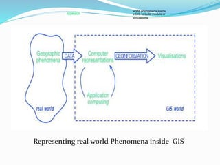
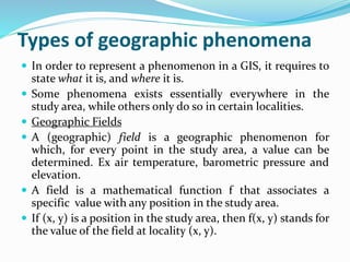
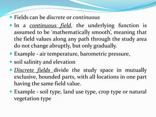
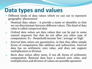
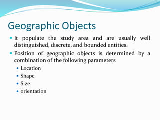
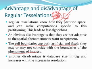
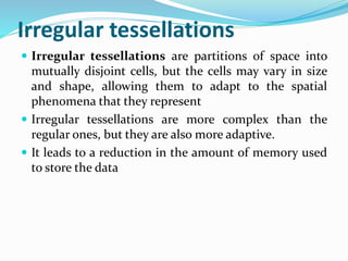
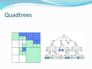
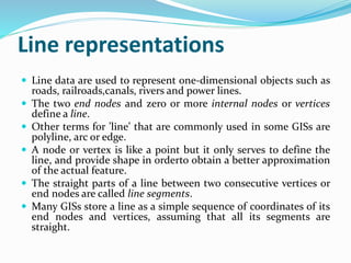
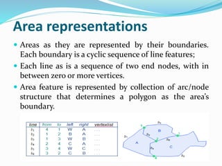
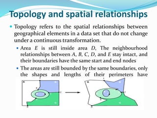
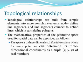
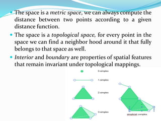
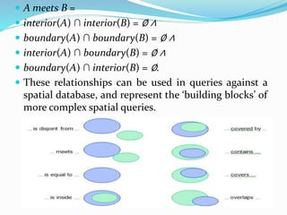
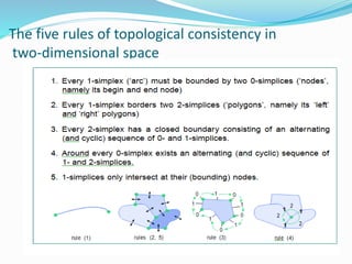
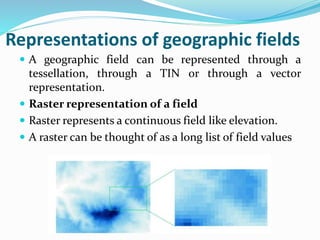
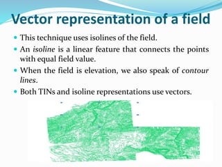
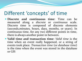
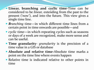
SlideShare a Scribd company logo
1 of 65
Download to read offline
Prof. Sanjana Khemka
Prahladrai Dalmia Lions College
Unit 1:Introduction to GIS
 The nature of GIS
 The real world and representations of it
 Geographic Information and Spatial Database
 Models and Representations of the real world
 Geographic Phenomena
 Computer Representations of Geographic Information
 Organizing and Managing Spatial Data
 The Temporal Dimension
What is GIS?
G stands for geographic, so GIS has something
to do with geography.
I stands for information, so GIS has something
to do with information, namely geographic
information.
S stands for system, so GIS is an integrated
system of geography and information tied
together.
What is GIS?
 •A computer system for
-collecting,
-storing,
-manipulating,
-analyzing,
-displaying, and
-querying
geographically related
information.
Definitions of GIS
 GIS is a particular form of Information System applied
to geographical data.
 GIS is a computer based tool that analyzes, stores,
manipulates and visualizes geographic information on
a map.
 A Geographic Information System is a system of
computer software, hardware and data, and the
personnel that make it possible to enter, manipulate,
analyze, and present information that is tied to a
location on the earth’s surface.
 A GIS is a computer-based system that provides the
following four sets of capabilities to handle
georeferenced data:
1. Data capture and preparation
2.Data management, including storage and maintenance
3. Data manipulation and analysis
4. Data presentation
Data capture and preparation
 Data capture and input is done using existing data or
by creating new data.
 New data can be created from sensed images, GPS
devices, field survey, user input and text files etc.
Data Management
 Data management refers to the storage and
maintenance of the data.
 Data is usually stored in tables in row and column
format.
 Data manipulation includes data verification, attribute
data management, insertion, updation, deletion and
retrieval in different forms.
Data Manipulation and analysis
 Once the data has been collected and organized, analysis
can be done using different analysis tools.
 Data Presentation
 After the data is gathered and stored, it is prepared for
producing output.
 The data presentation phase deals with putting it all
together into a format that communicates the result of data
analysis in the best possible way.
 For effective presentation, following point should be kept
in mind. What is message we want to portray, who the
audience is, what kind of presentation medium is used and
what techniques are available for representation.
GI System
 GI System is a combination of a functional GIS
software and hardware components, users to work on
software and infrastructure support.
 It is specialized software to facilitate input, process,
transform and analyze geospatial data.
GIS Application
 GIS software can be applied to many different to many
different applications.
GIS Applications
 Natural resource-based
 wildlife habitat analysis, migration routes planning
 Natural Resource Management
 Land Use Planning
 Natural Hazard assessment
 Environmental impact analysis (EIA)
 Groundwater modeling and contamination tracking
 Street network-based
 address matching - finding locations given street addresses
 vehicle routing and scheduling
 location analysis, site selection
 development of evacuation plans
 Land parcel-based
 Zoning, subdivision plan review
 Land record management
 environmental impact statements
 water quality management
 maintenance of ownership
 Facilities management
 locating underground pipes, cables
 balancing loads in electrical networks
 planning facility maintenance
 Others
 Crime analysis
 Market analysis
 Location based services
 In car navigation system
Who Uses GIS?
 Planning Strategies
 Police and Law Enforcement Agencies
 Foresters
 Industry
 Environmental Engineers
 Real Estate Professionals
 Telecommunications Professionals
 Emergency Response Organizations
 Local and Federal Government
 Health
 Transportation
 Geographers
 Market Developers
GIS components
 Computer system
 Hardware
 Software
 Geographic data
 People to carry out various management and analysis
tasks
 Hardware – it is the computer on which a GIS operates
 Software – it provides functions and tools needed to input
and store, query, performs analysis, and displays
geographic information in the form of maps or reports. All
GIS software packages rely on an underlying database
management system (DBMS) for storage and management
of the geographic and attribute data.
 Data - Data is one of the most important, and often
most expensive, components of a GIS.
 It is entered into a GIS using a technique called
digitizing.
 Digitizing is done by tracing the location, path or
boundary of geographic features either on a computer
screen using a scanned map in the background, or a
paper map that is attached to a digitizing tablet.
 Even data is available for free or for purchase from the
data provider or from a spatial data clearinghouse.
The real world and representations of it
 One of the main uses of GIS is as a tool to help us
make decisions.
 To do so we need to restrict ourselves to ‘some part’ of
the real world simply because it cannot be represented
completely.
 It will allow us to enter and store data, analyze the data
and transfer it to humans or to other systems.
MODELS
 A model is a representation of whole or some part of
the real world having certain characteristics in
common with the real world.
 It is used to study and operate on the model itself
instead of the real world in order to test what happens
under various conditions, and help us answer ‘what if’
analysis by changing the data or alter the parameters
of the model, and investigate the effects of the
changes.
 Models are of different types
 Static model- it represent a single state of affairs at any
point of time.
 Dynamic model- it is used for such systems,
Static model and Dynamic model
 It represent a single state of affairs at any point of time.
 Most maps and databases can be considered static models.
 Usually, developments or changes in the real world are not
easily recognized in these models
 Dynamic models – it emphasize changes that have taken
place, are taking place or may take place sometime in the
future.
 Dynamic models are inherently more complicated than
static models, and usually require much more
computation.
 Simulation models are an important class of dynamic
models that allow the simulation of real world processes.
Models as representations
 Models—as representations—come in many different
forms.
 The most familiar model is that of a map. A map is a
miniature representation of some part of the real world.
 Paper maps are the most common, but digital maps also
exist.
 Databases are another important class of models
 Digital models have enormous advantages over paper
models (such as maps).
 They are more flexible, and therefore more easily changed
for the purpose at hand.
 Application models- it refer to models with a specific
application
Maps
 A map is a graphic representation at a certain level of
detail, which is determined by the scale, having
physical boundaries and features.
 Map is a miniature representation of some port of the
re
 Cartography, is the science and art of map making,
functions as an interpreter, translating real world
phenomena into correct, clear and understandable
representations for our use.
 Maps are also a data source for other applications,
including the development of other maps.
Database
 A database is a repository for storing large amounts of data
 A database offers a number of techniques for storing and
analyzing data.
 A database can be used by multiple users at the same
time—i.e. it allows concurrent use
 A database allows the imposition of rules on the stored
data
 A database offers an easy to use data manipulation
language
 Databases can store almost any kind of data
Spatial databases
 Spatial database also known as geo-database can store
representations of real world geographic phenomena
for use in a GIS.
 It stores about spatial references systems, and supports
all kinds of analysis that are geographic in nature, such
as computation of distance and area.
 It may have point, line, and area or image
characteristics.
Spatial Analysis
 Spatial analysis is the general term for all manipulations of
spatial data carried out to improve one’s understanding of
the geographic phenomena that the data represents.
 It involves questions about how the data in various layers
might relate to each other, and how it varies over space
 The aim of spatial analysis is usually to gain a better
understanding of geographic phenomena through
discovering patterns that were previously unknown to us,
or to build arguments on which to take important
decisions.
 GIS functions for spatial analysis are simple and easy-to-
use, much more sophisticated, and demand higher levels of
analytical and operating skills
Models and representations of the real world
 Modeling is he process of producing an abstraction of
the real world to observe and study it easily.
 It is the process of representing key aspects of the real
world using computer system.
 These representation are made up of spatial data,
stored in computer memory.
 Modeling begins with the process of translating the
relevant aspects of the real world into a computer
representation.
 It can be done using direct observations using sensors,
and digitizing the sensor output for computer usage or
by indirect means.
world phenomena inside
a GIS to build models or
simulations.
Representing real world Phenomena inside GIS
Geographic phenomena
 A geographic phenomenon is something that
❖Can be named or described,
❖Can be georeferenced, and
❖Can be assigned a time (interval) at which it is/was
present.
 For instance, in water management, the objects of study might be river basins,
measurements of actual evaporation, ground water levels, irrigation levels,
water budgets and measurements of total water use.
 A spatial phenomena occur in a two- or three-dimensional Euclidean space.
 Euclidean space can be informally defined as a model of space in which
locations Euclidean space are represented by coordinates—(x, y) in 2D; (x, y, z)
in 3D—and distance and di-rection can defined with geometric formulas.In the
2D case, this is known as the Euclidean plane
Types of geographic phenomena
 In order to represent a phenomenon in a GIS, it requires to
state what it is, and where it is.
 Some phenomena exists essentially everywhere in the
study area, while others only do so in certain localities.
 Geographic Fields
 A (geographic) field is a geographic phenomenon for
which, for every point in the study area, a value can be
determined. Ex air temperature, barometric pressure and
elevation.
 A field is a mathematical function f that associates a
specific value with any position in the study area.
 If (x, y) is a position in the study area, then f(x, y) stands for
the value of the field at locality (x, y).
 Fields can be discrete or continuous
 In a continuous field, the underlying function is
assumed to be ‘mathematically smooth’, meaning that
the field values along any path through the study area
do not change abruptly, but only gradually.
 Example - air temperature, barometric pressure,
 soil salinity and elevation
 Discrete fields divide the study space in mutually
exclusive, bounded parts, with all locations in one part
having the same field value.
 Example - soil type, land use type, crop type or natural
vegetation type
Data types and values
 Different kinds of data values which we can use to represent
geographic ‘phenomena’
1. Nominal data values – it provide a name or identifier so that
we can discriminate between different values. This kind of data
value is called categorical data
2. Ordinal data values are data values that can be put in some
natural sequence but that do not allow any other type of
computation. Ex - Household income ‘low’, ‘average’ or ‘high’
3. Interval data values are quantitative, in that they allow simple
forms of computation like addition and subtraction. Interval
data has no arithmetic zero value, and does not support
multiplication or division
4. Ratio data values allow most, if not all, forms of arithmetic
computation. Rational data have a natural zero value, and
multiplication and division of values are possible operators
Geographic Objects
 It populate the study area and are usually well
distinguished, discrete, and bounded entities.
 Position of geographic objects is determined by a
combination of the following parameters
 Location
 Shape
 Size
 orientation
Boundaries
 Boundary is required where shape and/or size of
contiguous areas matter
 Boundary is used for geographic object and for discrete
geographic field.
 A crisp boundary is one that can be determined with
almost arbitrary precision, dependent only on the data
acquisition technique applied.
 Fuzzy boundaries contrast with crisp boundaries in that
the boundary is not a precise line, but rather itself an area
of transition.
 Crisp boundaries are more common in man-made
phenomena, whereas fuzzy boundaries are more common
with natural phenomena.
Computer representations of geographic information
 Geographic phenomenon can be represented in computer memory as
 Store as many (location, elevation) observation pairs as possible, or
 Find a symbolic representation of the elevation field function, as a
formula in x and y—like (3.0678x2 + 20.08x - 7.34y) or so—which can
be evaluated to give us the elevation at any given (x, y) location.
 Both of these approaches have their drawbacks
 The first suffers from the fact that , there are infinitely many locations.
 In second approach, it is extremely difficult to derive function for larger
areas.
 In GISs, a combination of both approaches is taken.
 We store a finite, but intelligently chosen set of (sample) locations with
their elevation.
 Interpolation function allows us to infer a reasonable elevation value
for locations that are not stored.
 Interpolation is made possible by a principle called spatial
autocorrelation
 fields are usually implemented with a tessellation approach, and
objects with a (topological) vector approach
Regular tessellations
 A tessellation (or tiling) is a partitioning of space into
mutually exclusive cells that together make up the
complete study space.
 With each cell, some (thematic) value is associated to
characterize that part of space.
 In all regular tessellations, the cells are of the same
shape and size, and the field attribute value assigned
to a cell is associated with the entire area occupied by
the cell.
Raster
 A raster is a set of regularly spaced (and contiguous)
cells with associated (field) values. The associated
values represent cell values, not point values.
 The size of the area that a single raster cell represents
is called the raster’s resolution.
 To improve on this continuity of cell
 Make the cell size smaller, so as to make the ‘continuity
gaps’ between the cells smaller
 Assume that a cell value only represents elevation for
one specific location in the cell.
Advantage and disadvantage of
Regular Tesselations
 Regular tessellations know how they partition space,
and can make computations specific to this
partitioning. This leads to fast algorithms
 An obvious disadvantage is that they are not adaptive
to the spatial phenomenon we want to represent.
 The cell boundaries are both artificial and fixed: they
may or may not coincide with the boundaries of the
phenomena of interest.
 another disadvantage is database size in big and
increases with the increase in resolution.
Irregular tessellations
 Irregular tessellations are partitions of space into
mutually disjoint cells, but the cells may vary in size
and shape, allowing them to adapt to the spatial
phenomena that they represent
 Irregular tessellations are more complex than the
regular ones, but they are also more adaptive.
 It leads to a reduction in the amount of memory used
to store the data
Quadtrees
 It is based on a regular tessellation of square cells, but
takes advantage of cases where neighbouring cells
have the same field value, so that they can together be
represented as one bigger cell.
 The quadtree that represents a raster is constructed by
repeatedly splitting up the area into four quadrants,
which are called NW, NE, SE, SW.
 This procedure stops when all the cells in a quadrant
have the same field value. The procedure produces an
upside-down, tree-like structure, known as a quadtree.
 In main memory, the nodes of a quadtree are
represented as records.
 Quadtrees are adaptive because they apply the spatial
autocorrelation principle, i.e. the locations that are
near in space are likely to have similar field values.
Vector representations
 Tessellations provide a georeference of the lower left
corner of the raster, plus an indicator of the raster’s
resolution
 Vector representations, explicitly associate
georeferences with the geographic phenomena.
 A georeference is a coordinate pair from some
geographic space, and is also known as a vector.
TIN (Triangulated Irregular Network)
 It is a representation for geographic fields that can be
considered a hybrid between tessellations and vector
representations.
 A TIN is a vector representation
 It is a commonly used data structure in GIS software
 It is one of the standard implementation techniques
for digital terrain models, but it can be used to
represent any continuous field.
 The principles behind a TIN are simple. It is built from
a set of locations for which we have a measurement,
for instance an elevation.
Delaunay triangulation
 It is an optimal triangulation.
 First property is triangles are as equilateral (‘equal-
sided’) as they can be, given the set of anchor points.
 The second property is that for each triangle, the
circumcircle through its three anchor points does not
contain any other anchor point.
Point representations
 Points are defined as single coordinate pairs (x, y) in
2D, or coordinate triplets (x, y, z) in 3D.
 Points are used to represent objects that are best
described as shape- and size-less, zero-dimensional
features.
Line representations
 Line data are used to represent one-dimensional objects such as
roads, railroads,canals, rivers and power lines.
 The two end nodes and zero or more internal nodes or vertices
define a line.
 Other terms for ’line’ that are commonly used in some GISs are
polyline, arc or edge.
 A node or vertex is like a point but it only serves to define the
line, and provide shape in orderto obtain a better approximation
of the actual feature.
 The straight parts of a line between two consecutive vertices or
end nodes are called line segments.
 Many GISs store a line as a simple sequence of coordinates of its
end nodes and vertices, assuming that all its segments are
straight.
Area representations
 Areas as they are represented by their boundaries.
Each boundary is a cyclic sequence of line features;
 Each line as is a sequence of two end nodes, with in
between zero or more vertices.
 Area feature is represented by collection of arc/node
structure that determines a polygon as the area’s
boundary.
Topology and spatial relationships
 Topology refers to the spatial relationships between
geographical elements in a data set that do not change
under a continuous transformation.
 Area E is still inside area D, The neighbourhood
relationships between A, B, C, D, and E stay intact, and
their boundaries have the same start and end nodes
 The areas are still bounded by the same boundaries, only
the shapes and lengths of their perimeters have
changed.
Topological relationships
 Topological relationships are built from simple
elements into more complex elements: nodes define
line segments, and line segments connect to define
lines, which in turn define polygons.
 The mathematical properties of the geometric space
used for spatial data can be described as follows:
 The space is a three-dimensional Euclidean space where
for every point we can determine its three-
dimensional coordinates as a triple (x, y, z) of
real numbers
 The space is a metric space, we can always compute the
distance between two points according to a given
distance function.
 The space is a topological space, for every point in the
space we can find a neighbor hood around it that fully
belongs to that space as well.
 Interior and boundary are properties of spatial features
that remain invariant under topological mappings.
 We can define within the topological space, features
that are easy to handle and that can be used as
representations of geographic objects.
 These features are called simplices as they are the
simplest geometric shapes of some dimension: point
(0-simplex), line segment (1-simplex), triangle (2-
simplex), and tetrahedron (3-simplex).
 When we combine various simplices into a single
feature, we obtain a simplicial complex
The topology of two dimensions
 Topological properties of interior and boundary can be
used to define relationships between spatial features.
 We can define the interior of a region R as the largest
set of points of R for which we can construct a disk-like
environorment around it that also falls completely
inside R.
 The boundary of R is the set of those points belonging
to R but that do not belong to the interior of R, i.e. one
cannot construct a disk-like environment around such
points that still belongs to R completely.
Set theory
 Consider a spatial region A. It has a boundary and an
interior, both seen as (infinite) sets of points, and
which are denoted by boundary(A) and interior(A),
respectively.
 We consider all possible combinations of
intersections(∩) between the boundary and the
interior of A with those of another region B, and test
whether they are the empty set (∅) or not.
 From these intersection patterns, we can derive eight
(mutually exclusive) spatial relationships between two
regions.
 A meets B =
 interior(A) ∩ interior(B) = ∅ ∧
 boundary(A) ∩ boundary(B) = ∅ ∧
 interior(A) ∩ boundary(B) = ∅ ∧
 boundary(A) ∩ interior(B) = ∅.
 These relationships can be used in queries against a
spatial database, and represent the ‘building blocks’ of
more complex spatial queries.
The five rules of topological consistency in
two-dimensional space
Scale and resolution
 Map scale can be defined as the ratio between the
distance on a paper map and the distance of the same
stretch in the terrain.
 A 1:50,000 scale map means that 1 cm on the map
represents 50,000 cm, i.e. 500 m, in the terrain.
 When applied to spatial data, the term resolution is
commonly associated with the cell width of the
tessellation applied
Representations of geographic fields
 A geographic field can be represented through a
tessellation, through a TIN or through a vector
representation.
 Raster representation of a field
 Raster represents a continuous field like elevation.
 A raster can be thought of as a long list of field values
Vector representation of a field
 This technique uses isolines of the field.
 An isoline is a linear feature that connects the points
with equal field value.
 When the field is elevation, we also speak of contour
lines.
 Both TINs and isoline representations use vectors.
Representation of geographic
objects
 It is supported with vectors. All, objects are identified
by the parameters of location, shape, size and
orientation and many of these parameters can be
expressed in terms of vectors.
 However, tessellations are still commonly used for
representing geographic objects
Organizing and managing spatial
data
 The main principle of data organization applied in GIS
systems is that of a spatial data layer.
 A spatial data layer is either a representation of a
continuous or discrete field, or a collection of objects
The temporal dimension
 Geographic phenomena are dynamic, they change over
time.
 Some features changes slowly, while other phenomena
change very rapidly.
 The temporal dimension is of a continuous nature.
 Therefore in order to represent it in a computer, we have to
‘discretize’ the time dimension.
 Spatiotemporal data models are ways of organizing
representations of space and time in a GIS.
 The most common technique is a ‘snapshot’ state that
represents a single point in time of an ongoing natural or
man-made process.
 We may store a series of these snapshot states to represent
change
Different ‘concepts’ of time
 Discrete and continuous time: Time can be
measured along a discrete or continuous scale.
Discrete time is composed of discrete elements
(seconds,minutes, hours, days, months, or years). In
continuous time, for any two different points in time,
there is always another point in between.
 Valid time and transaction time: Valid time is the
time when an event really happened, or a string of
events took place. Transaction time (or database time)
is the time when the event was stored in the database
or GIS
 Linear, branching and cyclic time-Time can be
considered to be linear, extending from the past to the
present (‘now’), and into the future. This view gives a
single time line.
 Branching time—in which different time lines from a
certain point in time onwards are possible—and
 cyclic time—in which repeating cycles such as seasons
or days of a week are recognized, make more sense and
can be useful.
 Time granularity- granularity is the precision of a
time value in a GIS or database
 Absolute and relative time-Absolute time marks a
point on the time line where events happen
 Relative time is indicated relative to other points in
time
References
 Principles of Geographic Information System –Sheth
Publication
 Principles of Geographic Information Systems - An
Introductory Text Book – Publication-The
international Institute of Geo Information Science and
Earth Observation

More Related Content

What's hot

Geo referencing by Mashhood Arif
Geo referencing by Mashhood ArifGeo referencing by Mashhood Arif
Geo referencing by Mashhood ArifKU Leuven
 
Remote Sensing:. Image Filtering
Remote Sensing:. Image FilteringRemote Sensing:. Image Filtering
Remote Sensing:. Image FilteringKamlesh Kumar
 
Remote Sensing Platforms and Sensors
Remote Sensing Platforms and SensorsRemote Sensing Platforms and Sensors
Remote Sensing Platforms and SensorsUday kumar Devalla
 
Application of GIS and RS in Watershed Management
Application of GIS and RS in Watershed ManagementApplication of GIS and RS in Watershed Management
Application of GIS and RS in Watershed Managementholegajendra
 
Remote sensing and image interpretation
Remote sensing and image interpretationRemote sensing and image interpretation
Remote sensing and image interpretationMd. Nazir Hossain
 
GIS presentation
GIS presentationGIS presentation
GIS presentationarniontech
 
Aerial photography.pptx
Aerial photography.pptxAerial photography.pptx
Aerial photography.pptxPramoda Raj
 
Types of aerial photographs
Types of aerial photographsTypes of aerial photographs
Types of aerial photographsHARITHANAIR15
 
Remote sensing principles-spectral signature-spectural range
Remote sensing principles-spectral signature-spectural rangeRemote sensing principles-spectral signature-spectural range
Remote sensing principles-spectral signature-spectural rangeMohsin Siddique
 
Application of remote sensing in forest ecosystem
Application of remote sensing in forest ecosystemApplication of remote sensing in forest ecosystem
Application of remote sensing in forest ecosystemaliya nasir
 
MODERN trends of GIS
MODERN trends of GISMODERN trends of GIS
MODERN trends of GISVAISHALI JAIN
 
Supervised and unsupervised classification techniques for satellite imagery i...
Supervised and unsupervised classification techniques for satellite imagery i...Supervised and unsupervised classification techniques for satellite imagery i...
Supervised and unsupervised classification techniques for satellite imagery i...gaup_geo
 
Data base management system
Data base management systemData base management system
Data base management systemPramoda Raj
 

What's hot (20)

Introduction to GIS
Introduction to GISIntroduction to GIS
Introduction to GIS
 
Geo referencing by Mashhood Arif
Geo referencing by Mashhood ArifGeo referencing by Mashhood Arif
Geo referencing by Mashhood Arif
 
Remote Sensing:. Image Filtering
Remote Sensing:. Image FilteringRemote Sensing:. Image Filtering
Remote Sensing:. Image Filtering
 
Functions of GIS
Functions of GISFunctions of GIS
Functions of GIS
 
Remote Sensing Platforms and Sensors
Remote Sensing Platforms and SensorsRemote Sensing Platforms and Sensors
Remote Sensing Platforms and Sensors
 
Application of GIS and RS in Watershed Management
Application of GIS and RS in Watershed ManagementApplication of GIS and RS in Watershed Management
Application of GIS and RS in Watershed Management
 
Remote sensing and image interpretation
Remote sensing and image interpretationRemote sensing and image interpretation
Remote sensing and image interpretation
 
georeference
georeferencegeoreference
georeference
 
GIS presentation
GIS presentationGIS presentation
GIS presentation
 
Aerial photography.pptx
Aerial photography.pptxAerial photography.pptx
Aerial photography.pptx
 
Raster data and Vector data
Raster data and Vector dataRaster data and Vector data
Raster data and Vector data
 
Types of aerial photographs
Types of aerial photographsTypes of aerial photographs
Types of aerial photographs
 
Introduction to GIS
Introduction to GISIntroduction to GIS
Introduction to GIS
 
Remote sensing principles-spectral signature-spectural range
Remote sensing principles-spectral signature-spectural rangeRemote sensing principles-spectral signature-spectural range
Remote sensing principles-spectral signature-spectural range
 
Application of remote sensing in forest ecosystem
Application of remote sensing in forest ecosystemApplication of remote sensing in forest ecosystem
Application of remote sensing in forest ecosystem
 
Spatial data for GIS
Spatial data for GISSpatial data for GIS
Spatial data for GIS
 
MODERN trends of GIS
MODERN trends of GISMODERN trends of GIS
MODERN trends of GIS
 
Supervised and unsupervised classification techniques for satellite imagery i...
Supervised and unsupervised classification techniques for satellite imagery i...Supervised and unsupervised classification techniques for satellite imagery i...
Supervised and unsupervised classification techniques for satellite imagery i...
 
Remote sensing and aerial photography
Remote sensing and aerial photographyRemote sensing and aerial photography
Remote sensing and aerial photography
 
Data base management system
Data base management systemData base management system
Data base management system
 

Similar to Principles of GIS unit 1

TYBSC IT PGIS Unit I Chapter I- Introduction to Geographic Information Systems
TYBSC IT PGIS Unit I  Chapter I- Introduction to Geographic Information SystemsTYBSC IT PGIS Unit I  Chapter I- Introduction to Geographic Information Systems
TYBSC IT PGIS Unit I Chapter I- Introduction to Geographic Information SystemsArti Parab Academics
 
geographic information system(gis) (1).pdf
geographic information system(gis) (1).pdfgeographic information system(gis) (1).pdf
geographic information system(gis) (1).pdfShubham30007
 
Principles of GIS unit 2
Principles of GIS unit 2Principles of GIS unit 2
Principles of GIS unit 2SanjanaKhemka1
 
GIS.INTRODUCTION TO GIS PACKAGES &GEOGRAPHIIC ANALYSIS
GIS.INTRODUCTION TO GIS PACKAGES &GEOGRAPHIIC ANALYSISGIS.INTRODUCTION TO GIS PACKAGES &GEOGRAPHIIC ANALYSIS
GIS.INTRODUCTION TO GIS PACKAGES &GEOGRAPHIIC ANALYSISTessaRaju
 
Introduction To Geographical Information System (GIS)
Introduction To Geographical Information System (GIS) Introduction To Geographical Information System (GIS)
Introduction To Geographical Information System (GIS) Ajay Singh Lodhi
 
Intro of geographic info system
Intro of geographic info systemIntro of geographic info system
Intro of geographic info systemJanak Parmar
 
Chapter one gis
Chapter one gisChapter one gis
Chapter one gisGokul Saud
 
Learning assignment on geographic information system
Learning assignment on geographic information systemLearning assignment on geographic information system
Learning assignment on geographic information systemMuhammad Tahir Mehmood
 
Geographic Information System - Swisstrack GPS Erfahrungen
Geographic Information System - Swisstrack GPS ErfahrungenGeographic Information System - Swisstrack GPS Erfahrungen
Geographic Information System - Swisstrack GPS ErfahrungenSwisstrack GPS Erfahrungen
 
EVS G.I.S CONCEPTS OF SCIENCE PPT.pptx
EVS  G.I.S CONCEPTS  OF SCIENCE PPT.pptxEVS  G.I.S CONCEPTS  OF SCIENCE PPT.pptx
EVS G.I.S CONCEPTS OF SCIENCE PPT.pptxUMANJUNATH
 
1_GEOGRAPHIC INFORMATION SYSTEMSTEM.pptx
1_GEOGRAPHIC INFORMATION SYSTEMSTEM.pptx1_GEOGRAPHIC INFORMATION SYSTEMSTEM.pptx
1_GEOGRAPHIC INFORMATION SYSTEMSTEM.pptxLaleanePale
 
Components of gis
Components of gisComponents of gis
Components of gisPramoda Raj
 
UNIt 6.pptxkkkkkkkkkkkkkkkkkkkkkkkkkkkkkkkkkkkkk
UNIt 6.pptxkkkkkkkkkkkkkkkkkkkkkkkkkkkkkkkkkkkkkUNIt 6.pptxkkkkkkkkkkkkkkkkkkkkkkkkkkkkkkkkkkkkk
UNIt 6.pptxkkkkkkkkkkkkkkkkkkkkkkkkkkkkkkkkkkkkkMrunmayee Manjari
 
What is GIS (PDF).pdf
What is GIS (PDF).pdfWhat is GIS (PDF).pdf
What is GIS (PDF).pdfKartikBhatt43
 

Similar to Principles of GIS unit 1 (20)

TYBSC IT PGIS Unit I Chapter I- Introduction to Geographic Information Systems
TYBSC IT PGIS Unit I  Chapter I- Introduction to Geographic Information SystemsTYBSC IT PGIS Unit I  Chapter I- Introduction to Geographic Information Systems
TYBSC IT PGIS Unit I Chapter I- Introduction to Geographic Information Systems
 
GIS
GISGIS
GIS
 
Gis
GisGis
Gis
 
geographic information system(gis) (1).pdf
geographic information system(gis) (1).pdfgeographic information system(gis) (1).pdf
geographic information system(gis) (1).pdf
 
Principles of GIS unit 2
Principles of GIS unit 2Principles of GIS unit 2
Principles of GIS unit 2
 
GIS.INTRODUCTION TO GIS PACKAGES &GEOGRAPHIIC ANALYSIS
GIS.INTRODUCTION TO GIS PACKAGES &GEOGRAPHIIC ANALYSISGIS.INTRODUCTION TO GIS PACKAGES &GEOGRAPHIIC ANALYSIS
GIS.INTRODUCTION TO GIS PACKAGES &GEOGRAPHIIC ANALYSIS
 
Introduction To Geographical Information System (GIS)
Introduction To Geographical Information System (GIS) Introduction To Geographical Information System (GIS)
Introduction To Geographical Information System (GIS)
 
Intro of geographic info system
Intro of geographic info systemIntro of geographic info system
Intro of geographic info system
 
introduction to GIS
introduction to GIS introduction to GIS
introduction to GIS
 
Gis
GisGis
Gis
 
Chapter one gis
Chapter one gisChapter one gis
Chapter one gis
 
Learning assignment on geographic information system
Learning assignment on geographic information systemLearning assignment on geographic information system
Learning assignment on geographic information system
 
Gis
GisGis
Gis
 
Geographic Information System - Swisstrack GPS Erfahrungen
Geographic Information System - Swisstrack GPS ErfahrungenGeographic Information System - Swisstrack GPS Erfahrungen
Geographic Information System - Swisstrack GPS Erfahrungen
 
GIS in Nutshell
GIS in NutshellGIS in Nutshell
GIS in Nutshell
 
EVS G.I.S CONCEPTS OF SCIENCE PPT.pptx
EVS  G.I.S CONCEPTS  OF SCIENCE PPT.pptxEVS  G.I.S CONCEPTS  OF SCIENCE PPT.pptx
EVS G.I.S CONCEPTS OF SCIENCE PPT.pptx
 
1_GEOGRAPHIC INFORMATION SYSTEMSTEM.pptx
1_GEOGRAPHIC INFORMATION SYSTEMSTEM.pptx1_GEOGRAPHIC INFORMATION SYSTEMSTEM.pptx
1_GEOGRAPHIC INFORMATION SYSTEMSTEM.pptx
 
Components of gis
Components of gisComponents of gis
Components of gis
 
UNIt 6.pptxkkkkkkkkkkkkkkkkkkkkkkkkkkkkkkkkkkkkk
UNIt 6.pptxkkkkkkkkkkkkkkkkkkkkkkkkkkkkkkkkkkkkkUNIt 6.pptxkkkkkkkkkkkkkkkkkkkkkkkkkkkkkkkkkkkkk
UNIt 6.pptxkkkkkkkkkkkkkkkkkkkkkkkkkkkkkkkkkkkkk
 
What is GIS (PDF).pdf
What is GIS (PDF).pdfWhat is GIS (PDF).pdf
What is GIS (PDF).pdf
 

Recently uploaded

FULL ENJOY 🔝 8264348440 🔝 Call Girls in Diplomatic Enclave | Delhi
FULL ENJOY 🔝 8264348440 🔝 Call Girls in Diplomatic Enclave | DelhiFULL ENJOY 🔝 8264348440 🔝 Call Girls in Diplomatic Enclave | Delhi
FULL ENJOY 🔝 8264348440 🔝 Call Girls in Diplomatic Enclave | Delhisoniya singh
 
Snow Chain-Integrated Tire for a Safe Drive on Winter Roads
Snow Chain-Integrated Tire for a Safe Drive on Winter RoadsSnow Chain-Integrated Tire for a Safe Drive on Winter Roads
Snow Chain-Integrated Tire for a Safe Drive on Winter RoadsHyundai Motor Group
 
Presentation on how to chat with PDF using ChatGPT code interpreter
Presentation on how to chat with PDF using ChatGPT code interpreterPresentation on how to chat with PDF using ChatGPT code interpreter
Presentation on how to chat with PDF using ChatGPT code interpreternaman860154
 
Benefits Of Flutter Compared To Other Frameworks
Benefits Of Flutter Compared To Other FrameworksBenefits Of Flutter Compared To Other Frameworks
Benefits Of Flutter Compared To Other FrameworksSoftradix Technologies
 
Making_way_through_DLL_hollowing_inspite_of_CFG_by_Debjeet Banerjee.pptx
Making_way_through_DLL_hollowing_inspite_of_CFG_by_Debjeet Banerjee.pptxMaking_way_through_DLL_hollowing_inspite_of_CFG_by_Debjeet Banerjee.pptx
Making_way_through_DLL_hollowing_inspite_of_CFG_by_Debjeet Banerjee.pptxnull - The Open Security Community
 
Hyderabad Call Girls Khairatabad ✨ 7001305949 ✨ Cheap Price Your Budget
Hyderabad Call Girls Khairatabad ✨ 7001305949 ✨ Cheap Price Your BudgetHyderabad Call Girls Khairatabad ✨ 7001305949 ✨ Cheap Price Your Budget
Hyderabad Call Girls Khairatabad ✨ 7001305949 ✨ Cheap Price Your BudgetEnjoy Anytime
 
How to Remove Document Management Hurdles with X-Docs?
How to Remove Document Management Hurdles with X-Docs?How to Remove Document Management Hurdles with X-Docs?
How to Remove Document Management Hurdles with X-Docs?XfilesPro
 
AI as an Interface for Commercial Buildings
AI as an Interface for Commercial BuildingsAI as an Interface for Commercial Buildings
AI as an Interface for Commercial BuildingsMemoori
 
CloudStudio User manual (basic edition):
CloudStudio User manual (basic edition):CloudStudio User manual (basic edition):
CloudStudio User manual (basic edition):comworks
 
Azure Monitor & Application Insight to monitor Infrastructure & Application
Azure Monitor & Application Insight to monitor Infrastructure & ApplicationAzure Monitor & Application Insight to monitor Infrastructure & Application
Azure Monitor & Application Insight to monitor Infrastructure & ApplicationAndikSusilo4
 
Maximizing Board Effectiveness 2024 Webinar.pptx
Maximizing Board Effectiveness 2024 Webinar.pptxMaximizing Board Effectiveness 2024 Webinar.pptx
Maximizing Board Effectiveness 2024 Webinar.pptxOnBoard
 
How to convert PDF to text with Nanonets
How to convert PDF to text with NanonetsHow to convert PDF to text with Nanonets
How to convert PDF to text with Nanonetsnaman860154
 
Injustice - Developers Among Us (SciFiDevCon 2024)
Injustice - Developers Among Us (SciFiDevCon 2024)Injustice - Developers Among Us (SciFiDevCon 2024)
Injustice - Developers Among Us (SciFiDevCon 2024)Allon Mureinik
 
Kotlin Multiplatform & Compose Multiplatform - Starter kit for pragmatics
Kotlin Multiplatform & Compose Multiplatform - Starter kit for pragmaticsKotlin Multiplatform & Compose Multiplatform - Starter kit for pragmatics
Kotlin Multiplatform & Compose Multiplatform - Starter kit for pragmaticscarlostorres15106
 
SQL Database Design For Developers at php[tek] 2024
SQL Database Design For Developers at php[tek] 2024SQL Database Design For Developers at php[tek] 2024
SQL Database Design For Developers at php[tek] 2024Scott Keck-Warren
 
IAC 2024 - IA Fast Track to Search Focused AI Solutions
IAC 2024 - IA Fast Track to Search Focused AI SolutionsIAC 2024 - IA Fast Track to Search Focused AI Solutions
IAC 2024 - IA Fast Track to Search Focused AI SolutionsEnterprise Knowledge
 
Install Stable Diffusion in windows machine
Install Stable Diffusion in windows machineInstall Stable Diffusion in windows machine
Install Stable Diffusion in windows machinePadma Pradeep
 
WhatsApp 9892124323 ✓Call Girls In Kalyan ( Mumbai ) secure service
WhatsApp 9892124323 ✓Call Girls In Kalyan ( Mumbai ) secure serviceWhatsApp 9892124323 ✓Call Girls In Kalyan ( Mumbai ) secure service
WhatsApp 9892124323 ✓Call Girls In Kalyan ( Mumbai ) secure servicePooja Nehwal
 
Integration and Automation in Practice: CI/CD in Mule Integration and Automat...
Integration and Automation in Practice: CI/CD in Mule Integration and Automat...Integration and Automation in Practice: CI/CD in Mule Integration and Automat...
Integration and Automation in Practice: CI/CD in Mule Integration and Automat...Patryk Bandurski
 
#StandardsGoals for 2024: What’s new for BISAC - Tech Forum 2024
#StandardsGoals for 2024: What’s new for BISAC - Tech Forum 2024#StandardsGoals for 2024: What’s new for BISAC - Tech Forum 2024
#StandardsGoals for 2024: What’s new for BISAC - Tech Forum 2024BookNet Canada
 

Recently uploaded (20)

FULL ENJOY 🔝 8264348440 🔝 Call Girls in Diplomatic Enclave | Delhi
FULL ENJOY 🔝 8264348440 🔝 Call Girls in Diplomatic Enclave | DelhiFULL ENJOY 🔝 8264348440 🔝 Call Girls in Diplomatic Enclave | Delhi
FULL ENJOY 🔝 8264348440 🔝 Call Girls in Diplomatic Enclave | Delhi
 
Snow Chain-Integrated Tire for a Safe Drive on Winter Roads
Snow Chain-Integrated Tire for a Safe Drive on Winter RoadsSnow Chain-Integrated Tire for a Safe Drive on Winter Roads
Snow Chain-Integrated Tire for a Safe Drive on Winter Roads
 
Presentation on how to chat with PDF using ChatGPT code interpreter
Presentation on how to chat with PDF using ChatGPT code interpreterPresentation on how to chat with PDF using ChatGPT code interpreter
Presentation on how to chat with PDF using ChatGPT code interpreter
 
Benefits Of Flutter Compared To Other Frameworks
Benefits Of Flutter Compared To Other FrameworksBenefits Of Flutter Compared To Other Frameworks
Benefits Of Flutter Compared To Other Frameworks
 
Making_way_through_DLL_hollowing_inspite_of_CFG_by_Debjeet Banerjee.pptx
Making_way_through_DLL_hollowing_inspite_of_CFG_by_Debjeet Banerjee.pptxMaking_way_through_DLL_hollowing_inspite_of_CFG_by_Debjeet Banerjee.pptx
Making_way_through_DLL_hollowing_inspite_of_CFG_by_Debjeet Banerjee.pptx
 
Hyderabad Call Girls Khairatabad ✨ 7001305949 ✨ Cheap Price Your Budget
Hyderabad Call Girls Khairatabad ✨ 7001305949 ✨ Cheap Price Your BudgetHyderabad Call Girls Khairatabad ✨ 7001305949 ✨ Cheap Price Your Budget
Hyderabad Call Girls Khairatabad ✨ 7001305949 ✨ Cheap Price Your Budget
 
How to Remove Document Management Hurdles with X-Docs?
How to Remove Document Management Hurdles with X-Docs?How to Remove Document Management Hurdles with X-Docs?
How to Remove Document Management Hurdles with X-Docs?
 
AI as an Interface for Commercial Buildings
AI as an Interface for Commercial BuildingsAI as an Interface for Commercial Buildings
AI as an Interface for Commercial Buildings
 
CloudStudio User manual (basic edition):
CloudStudio User manual (basic edition):CloudStudio User manual (basic edition):
CloudStudio User manual (basic edition):
 
Azure Monitor & Application Insight to monitor Infrastructure & Application
Azure Monitor & Application Insight to monitor Infrastructure & ApplicationAzure Monitor & Application Insight to monitor Infrastructure & Application
Azure Monitor & Application Insight to monitor Infrastructure & Application
 
Maximizing Board Effectiveness 2024 Webinar.pptx
Maximizing Board Effectiveness 2024 Webinar.pptxMaximizing Board Effectiveness 2024 Webinar.pptx
Maximizing Board Effectiveness 2024 Webinar.pptx
 
How to convert PDF to text with Nanonets
How to convert PDF to text with NanonetsHow to convert PDF to text with Nanonets
How to convert PDF to text with Nanonets
 
Injustice - Developers Among Us (SciFiDevCon 2024)
Injustice - Developers Among Us (SciFiDevCon 2024)Injustice - Developers Among Us (SciFiDevCon 2024)
Injustice - Developers Among Us (SciFiDevCon 2024)
 
Kotlin Multiplatform & Compose Multiplatform - Starter kit for pragmatics
Kotlin Multiplatform & Compose Multiplatform - Starter kit for pragmaticsKotlin Multiplatform & Compose Multiplatform - Starter kit for pragmatics
Kotlin Multiplatform & Compose Multiplatform - Starter kit for pragmatics
 
SQL Database Design For Developers at php[tek] 2024
SQL Database Design For Developers at php[tek] 2024SQL Database Design For Developers at php[tek] 2024
SQL Database Design For Developers at php[tek] 2024
 
IAC 2024 - IA Fast Track to Search Focused AI Solutions
IAC 2024 - IA Fast Track to Search Focused AI SolutionsIAC 2024 - IA Fast Track to Search Focused AI Solutions
IAC 2024 - IA Fast Track to Search Focused AI Solutions
 
Install Stable Diffusion in windows machine
Install Stable Diffusion in windows machineInstall Stable Diffusion in windows machine
Install Stable Diffusion in windows machine
 
WhatsApp 9892124323 ✓Call Girls In Kalyan ( Mumbai ) secure service
WhatsApp 9892124323 ✓Call Girls In Kalyan ( Mumbai ) secure serviceWhatsApp 9892124323 ✓Call Girls In Kalyan ( Mumbai ) secure service
WhatsApp 9892124323 ✓Call Girls In Kalyan ( Mumbai ) secure service
 
Integration and Automation in Practice: CI/CD in Mule Integration and Automat...
Integration and Automation in Practice: CI/CD in Mule Integration and Automat...Integration and Automation in Practice: CI/CD in Mule Integration and Automat...
Integration and Automation in Practice: CI/CD in Mule Integration and Automat...
 
#StandardsGoals for 2024: What’s new for BISAC - Tech Forum 2024
#StandardsGoals for 2024: What’s new for BISAC - Tech Forum 2024#StandardsGoals for 2024: What’s new for BISAC - Tech Forum 2024
#StandardsGoals for 2024: What’s new for BISAC - Tech Forum 2024
 

Principles of GIS unit 1

  • 1. Prof. Sanjana Khemka Prahladrai Dalmia Lions College
  • 2. Unit 1:Introduction to GIS  The nature of GIS  The real world and representations of it  Geographic Information and Spatial Database  Models and Representations of the real world  Geographic Phenomena  Computer Representations of Geographic Information  Organizing and Managing Spatial Data  The Temporal Dimension
  • 3. What is GIS? G stands for geographic, so GIS has something to do with geography. I stands for information, so GIS has something to do with information, namely geographic information. S stands for system, so GIS is an integrated system of geography and information tied together.
  • 4. What is GIS?  •A computer system for -collecting, -storing, -manipulating, -analyzing, -displaying, and -querying geographically related information.
  • 5. Definitions of GIS  GIS is a particular form of Information System applied to geographical data.  GIS is a computer based tool that analyzes, stores, manipulates and visualizes geographic information on a map.  A Geographic Information System is a system of computer software, hardware and data, and the personnel that make it possible to enter, manipulate, analyze, and present information that is tied to a location on the earth’s surface.
  • 6.  A GIS is a computer-based system that provides the following four sets of capabilities to handle georeferenced data: 1. Data capture and preparation 2.Data management, including storage and maintenance 3. Data manipulation and analysis 4. Data presentation
  • 7. Data capture and preparation  Data capture and input is done using existing data or by creating new data.  New data can be created from sensed images, GPS devices, field survey, user input and text files etc.
  • 8. Data Management  Data management refers to the storage and maintenance of the data.  Data is usually stored in tables in row and column format.  Data manipulation includes data verification, attribute data management, insertion, updation, deletion and retrieval in different forms.
  • 9. Data Manipulation and analysis  Once the data has been collected and organized, analysis can be done using different analysis tools.  Data Presentation  After the data is gathered and stored, it is prepared for producing output.  The data presentation phase deals with putting it all together into a format that communicates the result of data analysis in the best possible way.  For effective presentation, following point should be kept in mind. What is message we want to portray, who the audience is, what kind of presentation medium is used and what techniques are available for representation.
  • 10. GI System  GI System is a combination of a functional GIS software and hardware components, users to work on software and infrastructure support.  It is specialized software to facilitate input, process, transform and analyze geospatial data.
  • 11. GIS Application  GIS software can be applied to many different to many different applications.
  • 12. GIS Applications  Natural resource-based  wildlife habitat analysis, migration routes planning  Natural Resource Management  Land Use Planning  Natural Hazard assessment  Environmental impact analysis (EIA)  Groundwater modeling and contamination tracking  Street network-based  address matching - finding locations given street addresses  vehicle routing and scheduling  location analysis, site selection  development of evacuation plans
  • 13.  Land parcel-based  Zoning, subdivision plan review  Land record management  environmental impact statements  water quality management  maintenance of ownership  Facilities management  locating underground pipes, cables  balancing loads in electrical networks  planning facility maintenance  Others  Crime analysis  Market analysis  Location based services  In car navigation system
  • 14. Who Uses GIS?  Planning Strategies  Police and Law Enforcement Agencies  Foresters  Industry  Environmental Engineers  Real Estate Professionals  Telecommunications Professionals  Emergency Response Organizations  Local and Federal Government  Health  Transportation  Geographers  Market Developers
  • 15. GIS components  Computer system  Hardware  Software  Geographic data  People to carry out various management and analysis tasks
  • 16.  Hardware – it is the computer on which a GIS operates  Software – it provides functions and tools needed to input and store, query, performs analysis, and displays geographic information in the form of maps or reports. All GIS software packages rely on an underlying database management system (DBMS) for storage and management of the geographic and attribute data.
  • 17.  Data - Data is one of the most important, and often most expensive, components of a GIS.  It is entered into a GIS using a technique called digitizing.  Digitizing is done by tracing the location, path or boundary of geographic features either on a computer screen using a scanned map in the background, or a paper map that is attached to a digitizing tablet.  Even data is available for free or for purchase from the data provider or from a spatial data clearinghouse.
  • 18. The real world and representations of it  One of the main uses of GIS is as a tool to help us make decisions.  To do so we need to restrict ourselves to ‘some part’ of the real world simply because it cannot be represented completely.  It will allow us to enter and store data, analyze the data and transfer it to humans or to other systems.
  • 19. MODELS  A model is a representation of whole or some part of the real world having certain characteristics in common with the real world.  It is used to study and operate on the model itself instead of the real world in order to test what happens under various conditions, and help us answer ‘what if’ analysis by changing the data or alter the parameters of the model, and investigate the effects of the changes.  Models are of different types  Static model- it represent a single state of affairs at any point of time.  Dynamic model- it is used for such systems,
  • 20. Static model and Dynamic model  It represent a single state of affairs at any point of time.  Most maps and databases can be considered static models.  Usually, developments or changes in the real world are not easily recognized in these models  Dynamic models – it emphasize changes that have taken place, are taking place or may take place sometime in the future.  Dynamic models are inherently more complicated than static models, and usually require much more computation.  Simulation models are an important class of dynamic models that allow the simulation of real world processes.
  • 21. Models as representations  Models—as representations—come in many different forms.  The most familiar model is that of a map. A map is a miniature representation of some part of the real world.  Paper maps are the most common, but digital maps also exist.  Databases are another important class of models  Digital models have enormous advantages over paper models (such as maps).  They are more flexible, and therefore more easily changed for the purpose at hand.  Application models- it refer to models with a specific application
  • 22. Maps  A map is a graphic representation at a certain level of detail, which is determined by the scale, having physical boundaries and features.  Map is a miniature representation of some port of the re  Cartography, is the science and art of map making, functions as an interpreter, translating real world phenomena into correct, clear and understandable representations for our use.  Maps are also a data source for other applications, including the development of other maps.
  • 23. Database  A database is a repository for storing large amounts of data  A database offers a number of techniques for storing and analyzing data.  A database can be used by multiple users at the same time—i.e. it allows concurrent use  A database allows the imposition of rules on the stored data  A database offers an easy to use data manipulation language  Databases can store almost any kind of data
  • 24. Spatial databases  Spatial database also known as geo-database can store representations of real world geographic phenomena for use in a GIS.  It stores about spatial references systems, and supports all kinds of analysis that are geographic in nature, such as computation of distance and area.  It may have point, line, and area or image characteristics.
  • 25. Spatial Analysis  Spatial analysis is the general term for all manipulations of spatial data carried out to improve one’s understanding of the geographic phenomena that the data represents.  It involves questions about how the data in various layers might relate to each other, and how it varies over space  The aim of spatial analysis is usually to gain a better understanding of geographic phenomena through discovering patterns that were previously unknown to us, or to build arguments on which to take important decisions.  GIS functions for spatial analysis are simple and easy-to- use, much more sophisticated, and demand higher levels of analytical and operating skills
  • 26.
  • 27. Models and representations of the real world  Modeling is he process of producing an abstraction of the real world to observe and study it easily.  It is the process of representing key aspects of the real world using computer system.  These representation are made up of spatial data, stored in computer memory.  Modeling begins with the process of translating the relevant aspects of the real world into a computer representation.  It can be done using direct observations using sensors, and digitizing the sensor output for computer usage or by indirect means.
  • 28. world phenomena inside a GIS to build models or simulations. Representing real world Phenomena inside GIS
  • 29. Geographic phenomena  A geographic phenomenon is something that ❖Can be named or described, ❖Can be georeferenced, and ❖Can be assigned a time (interval) at which it is/was present.  For instance, in water management, the objects of study might be river basins, measurements of actual evaporation, ground water levels, irrigation levels, water budgets and measurements of total water use.  A spatial phenomena occur in a two- or three-dimensional Euclidean space.  Euclidean space can be informally defined as a model of space in which locations Euclidean space are represented by coordinates—(x, y) in 2D; (x, y, z) in 3D—and distance and di-rection can defined with geometric formulas.In the 2D case, this is known as the Euclidean plane
  • 30. Types of geographic phenomena  In order to represent a phenomenon in a GIS, it requires to state what it is, and where it is.  Some phenomena exists essentially everywhere in the study area, while others only do so in certain localities.  Geographic Fields  A (geographic) field is a geographic phenomenon for which, for every point in the study area, a value can be determined. Ex air temperature, barometric pressure and elevation.  A field is a mathematical function f that associates a specific value with any position in the study area.  If (x, y) is a position in the study area, then f(x, y) stands for the value of the field at locality (x, y).
  • 31.  Fields can be discrete or continuous  In a continuous field, the underlying function is assumed to be ‘mathematically smooth’, meaning that the field values along any path through the study area do not change abruptly, but only gradually.  Example - air temperature, barometric pressure,  soil salinity and elevation  Discrete fields divide the study space in mutually exclusive, bounded parts, with all locations in one part having the same field value.  Example - soil type, land use type, crop type or natural vegetation type
  • 32. Data types and values  Different kinds of data values which we can use to represent geographic ‘phenomena’ 1. Nominal data values – it provide a name or identifier so that we can discriminate between different values. This kind of data value is called categorical data 2. Ordinal data values are data values that can be put in some natural sequence but that do not allow any other type of computation. Ex - Household income ‘low’, ‘average’ or ‘high’ 3. Interval data values are quantitative, in that they allow simple forms of computation like addition and subtraction. Interval data has no arithmetic zero value, and does not support multiplication or division 4. Ratio data values allow most, if not all, forms of arithmetic computation. Rational data have a natural zero value, and multiplication and division of values are possible operators
  • 33. Geographic Objects  It populate the study area and are usually well distinguished, discrete, and bounded entities.  Position of geographic objects is determined by a combination of the following parameters  Location  Shape  Size  orientation
  • 34. Boundaries  Boundary is required where shape and/or size of contiguous areas matter  Boundary is used for geographic object and for discrete geographic field.  A crisp boundary is one that can be determined with almost arbitrary precision, dependent only on the data acquisition technique applied.  Fuzzy boundaries contrast with crisp boundaries in that the boundary is not a precise line, but rather itself an area of transition.  Crisp boundaries are more common in man-made phenomena, whereas fuzzy boundaries are more common with natural phenomena.
  • 35. Computer representations of geographic information  Geographic phenomenon can be represented in computer memory as  Store as many (location, elevation) observation pairs as possible, or  Find a symbolic representation of the elevation field function, as a formula in x and y—like (3.0678x2 + 20.08x - 7.34y) or so—which can be evaluated to give us the elevation at any given (x, y) location.  Both of these approaches have their drawbacks  The first suffers from the fact that , there are infinitely many locations.  In second approach, it is extremely difficult to derive function for larger areas.  In GISs, a combination of both approaches is taken.  We store a finite, but intelligently chosen set of (sample) locations with their elevation.  Interpolation function allows us to infer a reasonable elevation value for locations that are not stored.  Interpolation is made possible by a principle called spatial autocorrelation  fields are usually implemented with a tessellation approach, and objects with a (topological) vector approach
  • 36. Regular tessellations  A tessellation (or tiling) is a partitioning of space into mutually exclusive cells that together make up the complete study space.  With each cell, some (thematic) value is associated to characterize that part of space.  In all regular tessellations, the cells are of the same shape and size, and the field attribute value assigned to a cell is associated with the entire area occupied by the cell.
  • 37. Raster  A raster is a set of regularly spaced (and contiguous) cells with associated (field) values. The associated values represent cell values, not point values.  The size of the area that a single raster cell represents is called the raster’s resolution.  To improve on this continuity of cell  Make the cell size smaller, so as to make the ‘continuity gaps’ between the cells smaller  Assume that a cell value only represents elevation for one specific location in the cell.
  • 38. Advantage and disadvantage of Regular Tesselations  Regular tessellations know how they partition space, and can make computations specific to this partitioning. This leads to fast algorithms  An obvious disadvantage is that they are not adaptive to the spatial phenomenon we want to represent.  The cell boundaries are both artificial and fixed: they may or may not coincide with the boundaries of the phenomena of interest.  another disadvantage is database size in big and increases with the increase in resolution.
  • 39. Irregular tessellations  Irregular tessellations are partitions of space into mutually disjoint cells, but the cells may vary in size and shape, allowing them to adapt to the spatial phenomena that they represent  Irregular tessellations are more complex than the regular ones, but they are also more adaptive.  It leads to a reduction in the amount of memory used to store the data
  • 41.  It is based on a regular tessellation of square cells, but takes advantage of cases where neighbouring cells have the same field value, so that they can together be represented as one bigger cell.  The quadtree that represents a raster is constructed by repeatedly splitting up the area into four quadrants, which are called NW, NE, SE, SW.  This procedure stops when all the cells in a quadrant have the same field value. The procedure produces an upside-down, tree-like structure, known as a quadtree.  In main memory, the nodes of a quadtree are represented as records.  Quadtrees are adaptive because they apply the spatial autocorrelation principle, i.e. the locations that are near in space are likely to have similar field values.
  • 42. Vector representations  Tessellations provide a georeference of the lower left corner of the raster, plus an indicator of the raster’s resolution  Vector representations, explicitly associate georeferences with the geographic phenomena.  A georeference is a coordinate pair from some geographic space, and is also known as a vector.
  • 43. TIN (Triangulated Irregular Network)  It is a representation for geographic fields that can be considered a hybrid between tessellations and vector representations.  A TIN is a vector representation  It is a commonly used data structure in GIS software  It is one of the standard implementation techniques for digital terrain models, but it can be used to represent any continuous field.  The principles behind a TIN are simple. It is built from a set of locations for which we have a measurement, for instance an elevation.
  • 44.
  • 45. Delaunay triangulation  It is an optimal triangulation.  First property is triangles are as equilateral (‘equal- sided’) as they can be, given the set of anchor points.  The second property is that for each triangle, the circumcircle through its three anchor points does not contain any other anchor point.
  • 46. Point representations  Points are defined as single coordinate pairs (x, y) in 2D, or coordinate triplets (x, y, z) in 3D.  Points are used to represent objects that are best described as shape- and size-less, zero-dimensional features.
  • 47. Line representations  Line data are used to represent one-dimensional objects such as roads, railroads,canals, rivers and power lines.  The two end nodes and zero or more internal nodes or vertices define a line.  Other terms for ’line’ that are commonly used in some GISs are polyline, arc or edge.  A node or vertex is like a point but it only serves to define the line, and provide shape in orderto obtain a better approximation of the actual feature.  The straight parts of a line between two consecutive vertices or end nodes are called line segments.  Many GISs store a line as a simple sequence of coordinates of its end nodes and vertices, assuming that all its segments are straight.
  • 48. Area representations  Areas as they are represented by their boundaries. Each boundary is a cyclic sequence of line features;  Each line as is a sequence of two end nodes, with in between zero or more vertices.  Area feature is represented by collection of arc/node structure that determines a polygon as the area’s boundary.
  • 49. Topology and spatial relationships  Topology refers to the spatial relationships between geographical elements in a data set that do not change under a continuous transformation.  Area E is still inside area D, The neighbourhood relationships between A, B, C, D, and E stay intact, and their boundaries have the same start and end nodes  The areas are still bounded by the same boundaries, only the shapes and lengths of their perimeters have changed.
  • 50. Topological relationships  Topological relationships are built from simple elements into more complex elements: nodes define line segments, and line segments connect to define lines, which in turn define polygons.  The mathematical properties of the geometric space used for spatial data can be described as follows:  The space is a three-dimensional Euclidean space where for every point we can determine its three- dimensional coordinates as a triple (x, y, z) of real numbers
  • 51.  The space is a metric space, we can always compute the distance between two points according to a given distance function.  The space is a topological space, for every point in the space we can find a neighbor hood around it that fully belongs to that space as well.  Interior and boundary are properties of spatial features that remain invariant under topological mappings.
  • 52.  We can define within the topological space, features that are easy to handle and that can be used as representations of geographic objects.  These features are called simplices as they are the simplest geometric shapes of some dimension: point (0-simplex), line segment (1-simplex), triangle (2- simplex), and tetrahedron (3-simplex).  When we combine various simplices into a single feature, we obtain a simplicial complex
  • 53. The topology of two dimensions  Topological properties of interior and boundary can be used to define relationships between spatial features.  We can define the interior of a region R as the largest set of points of R for which we can construct a disk-like environorment around it that also falls completely inside R.  The boundary of R is the set of those points belonging to R but that do not belong to the interior of R, i.e. one cannot construct a disk-like environment around such points that still belongs to R completely.
  • 54. Set theory  Consider a spatial region A. It has a boundary and an interior, both seen as (infinite) sets of points, and which are denoted by boundary(A) and interior(A), respectively.  We consider all possible combinations of intersections(∩) between the boundary and the interior of A with those of another region B, and test whether they are the empty set (∅) or not.  From these intersection patterns, we can derive eight (mutually exclusive) spatial relationships between two regions.
  • 55.  A meets B =  interior(A) ∩ interior(B) = ∅ ∧  boundary(A) ∩ boundary(B) = ∅ ∧  interior(A) ∩ boundary(B) = ∅ ∧  boundary(A) ∩ interior(B) = ∅.  These relationships can be used in queries against a spatial database, and represent the ‘building blocks’ of more complex spatial queries.
  • 56. The five rules of topological consistency in two-dimensional space
  • 57. Scale and resolution  Map scale can be defined as the ratio between the distance on a paper map and the distance of the same stretch in the terrain.  A 1:50,000 scale map means that 1 cm on the map represents 50,000 cm, i.e. 500 m, in the terrain.  When applied to spatial data, the term resolution is commonly associated with the cell width of the tessellation applied
  • 58. Representations of geographic fields  A geographic field can be represented through a tessellation, through a TIN or through a vector representation.  Raster representation of a field  Raster represents a continuous field like elevation.  A raster can be thought of as a long list of field values
  • 59. Vector representation of a field  This technique uses isolines of the field.  An isoline is a linear feature that connects the points with equal field value.  When the field is elevation, we also speak of contour lines.  Both TINs and isoline representations use vectors.
  • 60. Representation of geographic objects  It is supported with vectors. All, objects are identified by the parameters of location, shape, size and orientation and many of these parameters can be expressed in terms of vectors.  However, tessellations are still commonly used for representing geographic objects
  • 61. Organizing and managing spatial data  The main principle of data organization applied in GIS systems is that of a spatial data layer.  A spatial data layer is either a representation of a continuous or discrete field, or a collection of objects
  • 62. The temporal dimension  Geographic phenomena are dynamic, they change over time.  Some features changes slowly, while other phenomena change very rapidly.  The temporal dimension is of a continuous nature.  Therefore in order to represent it in a computer, we have to ‘discretize’ the time dimension.  Spatiotemporal data models are ways of organizing representations of space and time in a GIS.  The most common technique is a ‘snapshot’ state that represents a single point in time of an ongoing natural or man-made process.  We may store a series of these snapshot states to represent change
  • 63. Different ‘concepts’ of time  Discrete and continuous time: Time can be measured along a discrete or continuous scale. Discrete time is composed of discrete elements (seconds,minutes, hours, days, months, or years). In continuous time, for any two different points in time, there is always another point in between.  Valid time and transaction time: Valid time is the time when an event really happened, or a string of events took place. Transaction time (or database time) is the time when the event was stored in the database or GIS
  • 64.  Linear, branching and cyclic time-Time can be considered to be linear, extending from the past to the present (‘now’), and into the future. This view gives a single time line.  Branching time—in which different time lines from a certain point in time onwards are possible—and  cyclic time—in which repeating cycles such as seasons or days of a week are recognized, make more sense and can be useful.  Time granularity- granularity is the precision of a time value in a GIS or database  Absolute and relative time-Absolute time marks a point on the time line where events happen  Relative time is indicated relative to other points in time
  • 65. References  Principles of Geographic Information System –Sheth Publication  Principles of Geographic Information Systems - An Introductory Text Book – Publication-The international Institute of Geo Information Science and Earth Observation