SlideShare a Scribd company logo
1 of 24
OSCI 7-10
Earth Science Teacher Institute
Elevation:
Topography and Bathymetry
Early History of Plate Tectonics
Goals and Objectives
• Define topography and bathymetry
• Consider questions about the elevations of
continents and the ocean floor
• Understand what methods were used
historically and are used today to determine
the topography of the earth
• Understand the connection between
elevation/bathymetry and the theory of plate
tectonics
• Think about a question
• Think about devising a method and collecting
data to try to answer that question
• Help students sum up what they have learned
(Synthesis)
Theory of Plate Tectonics
The theory of plate tectonics was created and
subsequently supported by a variety of data,
starting with elevation.
Topography of Earth above sea level:
(“elevation”)
It took centuries to develop
a map of “the earth”
• Eratosthenes created the
first known map of the world
(ca. 220 B.C.)
• Crates of Mallos constructed
the first globe
(ca. 150 B.C.)
Patterns: Random? Clumped? Linear? ? ? ?
Why? - one cause? many causes?
Some questions
tackled by early
oceanographers
probably included:
How deep is the ocean?
Where is it deepest?
How deep is the center of the ocean?
Is the ocean floor flat or bumpy? Where?
Is there a relationship between topography on land and in
the ocean? If so, what is that relationship?
•Elevations of Earth below sea level is
called “bathymetry”
Today we know that the ocean floor has
mountains, valleys, plains, and other
features similar to what we see on land.
Why does the ocean have the depths it does?
Why do ocean depths have the patterns we see?
Are land and ocean elevations related?
The Theory of Plate Tectonics
• Elevation patterns
– Not random - that is, there ARE patterns
– Continents are clumped
– Mountains are linear high areas surrounded by
vast expanses of lower, flatter areas
– The ocean floor shows similar patterns of high
ridges, abyssal plains, and deep trenches
– Most elevations on earth fall either around
200 m above sea level or 4,000 m below sea
level
Reinforce:
–Scientific data are real measurements
–They are measured by real people
–They do not just appear by magic
–They are not much different from what
we did - mostly differ in sophistication of
equipment - like echo-sounding above
Today, scientists use
remote sensing of
multibeam echo sounding
and satellite altimetry,
predicting topography of
the bottom from the surface
of the ocean.
Satellite altimeter data of world’s oceans, measuring the surface of the
ocean as it bulges over underwater features. From:
http://www.ngdc.noaa.gov/mgg/bathymetry/predicted/explore.HTML#intro
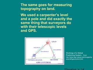
The same goes for measuring
topography on land.
We used a carpenter’s level
and a pole and did exactly the
same thing that surveyors do
with their telescopic levels
and GPS.
Workings of a Global
Positioning System. From:
http://www.tsgc.utexas.edu/images/sp
acecraft/gps/control.html
But back to patterns …
One of the first patterns
recognized, historically, had
to do with the shapes of the
continents.
1800 - German naturalist Alexander von Humboldt
hypothesized that the continents on either side of
Atlantic Ocean were once joined based on how the
bulge of South America fit into the curve of Africa.
•A historical note - this was first proposed by Abraham Ortelius three
centuries earlier!
1858 - Snider-Pellegrini’s maps from http://pubs.usgs.gov/publications//text/historical.html
Then around 1850 - French scientist Antonio Snider-Pellegrini
went a step further:
• Suggested N. Am. and Europe were once connected based
on identical fossil plants in coal deposits
• Pennsylvanian period - 325 to 286 mya (million years ago)
Late 1800s - Austrian geologist Edward Seuss
• Continents had all been part of one ancient continent
• Coined term Gondwanaland
• Based on similarities of plant fossils in South America, India,
Australia, Africa and Antarctica
One thing that scientists must
deal with is uncertainty.
• A hypothesis is one suggested explanation to
an observed pattern or phenomenon
•A theory has been “tested.”
•Are theories ever discarded? Of course.
And back to patterns again…
1908 - U.S. geologist Frank Taylor
• Continents had collided at some time
• Those collisions had created some of the
world’s mountain ranges
• Based on rock formations and minerals in
Caledonian Mts. of Europe and the
Appalachian Mts. of North America
• Also thought the mid-Atlantic Ridge (a high
ridge dividing the Atlantic Ocean from north
to south) was the former boundary between
the continents
Development of the theory of
continents moving
• First proposed by Frank Taylor, but was
developed using all the available evidence
by Alfred Wegener, a German
meteorologist, in 1912
• Evidence:
– Geology (mountain range, rock and mineral patterns)
– Climatology (tropical fossils in Antarctica)
– Paleontology (fossils)
– Continental shapes, including continental shelf contours
– Differing densities of continental and oceanic rock
Continental Drift
• Wegener’s hypothesis of “continental drift”
– "Entstehung der Kontinente und Ozeane”
(The Origin of Continents and Oceans)
"It placed an easily comprehensible,
tremendously exciting structure of ideas upon a
solid foundation. It released the continents from
the Earth's core and transformed them into
icebergs of gneiss [granite] on a sea of basalt. It
let them float and drift, break apart and
converge. Where they broke away, cracks, rifts,
trenches remain; where they collided, ranges of
folded mountains appear.”
Hans Cloos
Scientific Ire
• Wegener’s hypothesis was not popular
• Major problem - what forces could cause
continents to move?
• Two possibilities:
– Centrifugal force
– Westward tidal drag generated by the
gravitational pull of the sun and moon
– But these were just hypotheses with no data …
Although down, the theory of continental
drift was not completely out. Some
scientists were making their own
hypotheses about what patterns could be
explained by continents moving around.

More Related Content

What's hot

Cycle of erosion, davis and penk
Cycle of erosion, davis and penkCycle of erosion, davis and penk
Cycle of erosion, davis and penkRajithK
 
Introduction to Geomorphology
Introduction to Geomorphology Introduction to Geomorphology
Introduction to Geomorphology P.K. Mani
 
Koppen Climate Classification
Koppen Climate ClassificationKoppen Climate Classification
Koppen Climate ClassificationAshiMirzaa
 
Topography and its representation
Topography and its representationTopography and its representation
Topography and its representationAmit K. Mishra
 
Movement of Ocean water
Movement of Ocean waterMovement of Ocean water
Movement of Ocean waterSaloni777
 
Continental drift theory of A. Wegener
Continental drift theory of A. WegenerContinental drift theory of A. Wegener
Continental drift theory of A. WegenerAgastirishi Toradmal
 
Temperate Cyclones
Temperate CyclonesTemperate Cyclones
Temperate CyclonesJohn Lanser
 
STATISTICAL METHODS IN GEOGRAPHY
STATISTICAL METHODS IN GEOGRAPHYSTATISTICAL METHODS IN GEOGRAPHY
STATISTICAL METHODS IN GEOGRAPHYKalahandi University
 
Geomorphology at a glance: Major landforms
Geomorphology at a glance: Major landformsGeomorphology at a glance: Major landforms
Geomorphology at a glance: Major landformsP.K. Mani
 
Final ppt uniformitarianism
Final ppt uniformitarianism  Final ppt uniformitarianism
Final ppt uniformitarianism RAJKUMARPOREL
 
Geographic Concepts
Geographic ConceptsGeographic Concepts
Geographic Conceptsaaurorap
 
Fluvial depositional landform geomorphology
Fluvial depositional  landform geomorphologyFluvial depositional  landform geomorphology
Fluvial depositional landform geomorphologyShivam Jain
 
Humanistic geography
Humanistic geographyHumanistic geography
Humanistic geographybw3685
 
Contributions of greek scholars in geography
Contributions of greek scholars in geographyContributions of greek scholars in geography
Contributions of greek scholars in geographyMuhammadBilawal20
 

What's hot (20)

Cycle of erosion, davis and penk
Cycle of erosion, davis and penkCycle of erosion, davis and penk
Cycle of erosion, davis and penk
 
Introduction to Geomorphology
Introduction to Geomorphology Introduction to Geomorphology
Introduction to Geomorphology
 
Topography
TopographyTopography
Topography
 
Koppen Climate Classification
Koppen Climate ClassificationKoppen Climate Classification
Koppen Climate Classification
 
Topography and its representation
Topography and its representationTopography and its representation
Topography and its representation
 
Movement of Ocean water
Movement of Ocean waterMovement of Ocean water
Movement of Ocean water
 
Continental drift theory of A. Wegener
Continental drift theory of A. WegenerContinental drift theory of A. Wegener
Continental drift theory of A. Wegener
 
Temperate Cyclones
Temperate CyclonesTemperate Cyclones
Temperate Cyclones
 
STATISTICAL METHODS IN GEOGRAPHY
STATISTICAL METHODS IN GEOGRAPHYSTATISTICAL METHODS IN GEOGRAPHY
STATISTICAL METHODS IN GEOGRAPHY
 
Geomorphology at a glance: Major landforms
Geomorphology at a glance: Major landformsGeomorphology at a glance: Major landforms
Geomorphology at a glance: Major landforms
 
Final ppt uniformitarianism
Final ppt uniformitarianism  Final ppt uniformitarianism
Final ppt uniformitarianism
 
Topography of ocean floors
Topography of ocean floorsTopography of ocean floors
Topography of ocean floors
 
Topographic Maps Notes
Topographic Maps NotesTopographic Maps Notes
Topographic Maps Notes
 
Fluvial processes and landforms
Fluvial processes and landformsFluvial processes and landforms
Fluvial processes and landforms
 
Climatology
ClimatologyClimatology
Climatology
 
Geographic Concepts
Geographic ConceptsGeographic Concepts
Geographic Concepts
 
Koppen system
Koppen systemKoppen system
Koppen system
 
Fluvial depositional landform geomorphology
Fluvial depositional  landform geomorphologyFluvial depositional  landform geomorphology
Fluvial depositional landform geomorphology
 
Humanistic geography
Humanistic geographyHumanistic geography
Humanistic geography
 
Contributions of greek scholars in geography
Contributions of greek scholars in geographyContributions of greek scholars in geography
Contributions of greek scholars in geography
 

Viewers also liked

Factors affecting the climate
Factors affecting the climateFactors affecting the climate
Factors affecting the climatenhojyer sigz
 
2 - Factors Influencing Climate (Summary)
2 - Factors Influencing Climate (Summary)2 - Factors Influencing Climate (Summary)
2 - Factors Influencing Climate (Summary)Ecumene
 
Climate and Ocean Currents
Climate and Ocean CurrentsClimate and Ocean Currents
Climate and Ocean Currentsdwinter1
 
Oceans And Climate
Oceans And ClimateOceans And Climate
Oceans And ClimateTerri Kelsey
 
Ocean currents ppt cscope
Ocean currents ppt cscopeOcean currents ppt cscope
Ocean currents ppt cscopeJenny Dixon
 

Viewers also liked (7)

Topography powerpoint
Topography powerpointTopography powerpoint
Topography powerpoint
 
Factors affecting the climate
Factors affecting the climateFactors affecting the climate
Factors affecting the climate
 
2 - Factors Influencing Climate (Summary)
2 - Factors Influencing Climate (Summary)2 - Factors Influencing Climate (Summary)
2 - Factors Influencing Climate (Summary)
 
Climate and Ocean Currents
Climate and Ocean CurrentsClimate and Ocean Currents
Climate and Ocean Currents
 
Climate powerpoint
Climate powerpointClimate powerpoint
Climate powerpoint
 
Oceans And Climate
Oceans And ClimateOceans And Climate
Oceans And Climate
 
Ocean currents ppt cscope
Ocean currents ppt cscopeOcean currents ppt cscope
Ocean currents ppt cscope
 

Similar to What is Topography

Dynamic Earth Chapter 3 Plate Tectonics 1
Dynamic Earth Chapter 3 Plate Tectonics 1Dynamic Earth Chapter 3 Plate Tectonics 1
Dynamic Earth Chapter 3 Plate Tectonics 1Tom Jenkins
 
Lines of Evidences
Lines of EvidencesLines of Evidences
Lines of EvidencesLeiane Luna
 
Lines of Evidences_week8.pptx
Lines of Evidences_week8.pptxLines of Evidences_week8.pptx
Lines of Evidences_week8.pptxLeiane Luna
 
Continentaldrift
ContinentaldriftContinentaldrift
ContinentaldriftElbertNatal1
 
continentahjjjjjjjjjghghhjghuyldrift.ppt
continentahjjjjjjjjjghghhjghuyldrift.pptcontinentahjjjjjjjjjghghhjghuyldrift.ppt
continentahjjjjjjjjjghghhjghuyldrift.pptkrishnarajgire71
 
Plate Tectonics I
Plate Tectonics IPlate Tectonics I
Plate Tectonics IMark McGinley
 
Plate tectonics
Plate tectonicsPlate tectonics
Plate tectonicszeeshan Ahmad
 
Chapter 3 Plate Tectonics
Chapter 3 Plate TectonicsChapter 3 Plate Tectonics
Chapter 3 Plate TectonicsTom Jenkins
 
Chapter 3 Plate Tectonics
Chapter 3 Plate TectonicsChapter 3 Plate Tectonics
Chapter 3 Plate TectonicsTom Jenkins
 
Chapter 3 Plate Tectonics
Chapter 3 Plate TectonicsChapter 3 Plate Tectonics
Chapter 3 Plate TectonicsTom Jenkins
 
Chapter 3 Plate Tectonics
Chapter 3 Plate TectonicsChapter 3 Plate Tectonics
Chapter 3 Plate TectonicsTom Jenkins
 
CONTINENTAL DRIFT THEORY PPT
CONTINENTAL DRIFT THEORY PPT CONTINENTAL DRIFT THEORY PPT
CONTINENTAL DRIFT THEORY PPT Ram Shankar
 
Plate movement ppt
Plate movement pptPlate movement ppt
Plate movement pptLeeanne Rogers
 
Earth Expansion Tectonics - Historical ways of viewing the Earth (Part 3)
Earth Expansion Tectonics - Historical ways of viewing the Earth (Part 3)Earth Expansion Tectonics - Historical ways of viewing the Earth (Part 3)
Earth Expansion Tectonics - Historical ways of viewing the Earth (Part 3)Proyecto Matriz
 
Introduction marine geology
Introduction marine geologyIntroduction marine geology
Introduction marine geologyDedy Aslam
 
Natural Disasters Topic 3 (Plate Tectonics)
Natural Disasters Topic 3 (Plate Tectonics)Natural Disasters Topic 3 (Plate Tectonics)
Natural Disasters Topic 3 (Plate Tectonics)William W. Little
 
Continental Drift Plate Tectonics
Continental Drift Plate TectonicsContinental Drift Plate Tectonics
Continental Drift Plate TectonicsJan Parker
 
Tectonics: Plate Tectonic Theory history
Tectonics: Plate Tectonic Theory historyTectonics: Plate Tectonic Theory history
Tectonics: Plate Tectonic Theory historygeomillie
 

Similar to What is Topography (20)

Dynamic Earth Chapter 3 Plate Tectonics 1
Dynamic Earth Chapter 3 Plate Tectonics 1Dynamic Earth Chapter 3 Plate Tectonics 1
Dynamic Earth Chapter 3 Plate Tectonics 1
 
Lines of Evidences
Lines of EvidencesLines of Evidences
Lines of Evidences
 
Lines of Evidences_week8.pptx
Lines of Evidences_week8.pptxLines of Evidences_week8.pptx
Lines of Evidences_week8.pptx
 
Continentaldrift
ContinentaldriftContinentaldrift
Continentaldrift
 
continentahjjjjjjjjjghghhjghuyldrift.ppt
continentahjjjjjjjjjghghhjghuyldrift.pptcontinentahjjjjjjjjjghghhjghuyldrift.ppt
continentahjjjjjjjjjghghhjghuyldrift.ppt
 
Plate Tectonics I
Plate Tectonics IPlate Tectonics I
Plate Tectonics I
 
Plate tectonics
Plate tectonicsPlate tectonics
Plate tectonics
 
Chapter 3 Plate Tectonics
Chapter 3 Plate TectonicsChapter 3 Plate Tectonics
Chapter 3 Plate Tectonics
 
Chapter 3 Plate Tectonics
Chapter 3 Plate TectonicsChapter 3 Plate Tectonics
Chapter 3 Plate Tectonics
 
Chapter 3 Plate Tectonics
Chapter 3 Plate TectonicsChapter 3 Plate Tectonics
Chapter 3 Plate Tectonics
 
Chapter 3 Plate Tectonics
Chapter 3 Plate TectonicsChapter 3 Plate Tectonics
Chapter 3 Plate Tectonics
 
Plate tectonics unit
Plate tectonics unitPlate tectonics unit
Plate tectonics unit
 
CONTINENTAL DRIFT THEORY PPT
CONTINENTAL DRIFT THEORY PPT CONTINENTAL DRIFT THEORY PPT
CONTINENTAL DRIFT THEORY PPT
 
Plate movement ppt
Plate movement pptPlate movement ppt
Plate movement ppt
 
Earth Expansion Tectonics - Historical ways of viewing the Earth (Part 3)
Earth Expansion Tectonics - Historical ways of viewing the Earth (Part 3)Earth Expansion Tectonics - Historical ways of viewing the Earth (Part 3)
Earth Expansion Tectonics - Historical ways of viewing the Earth (Part 3)
 
Introduction marine geology
Introduction marine geologyIntroduction marine geology
Introduction marine geology
 
Natural Disasters Topic 3 (Plate Tectonics)
Natural Disasters Topic 3 (Plate Tectonics)Natural Disasters Topic 3 (Plate Tectonics)
Natural Disasters Topic 3 (Plate Tectonics)
 
Continental Drift Plate Tectonics
Continental Drift Plate TectonicsContinental Drift Plate Tectonics
Continental Drift Plate Tectonics
 
Evidence... notes
Evidence... notesEvidence... notes
Evidence... notes
 
Tectonics: Plate Tectonic Theory history
Tectonics: Plate Tectonic Theory historyTectonics: Plate Tectonic Theory history
Tectonics: Plate Tectonic Theory history
 

More from Sells Middle School (20)

Topomaps
TopomapsTopomaps
Topomaps
 
Evidence... notes
Evidence... notesEvidence... notes
Evidence... notes
 
Periodic table
Periodic tablePeriodic table
Periodic table
 
Atoms bonding
Atoms bondingAtoms bonding
Atoms bonding
 
Chemical reactions
Chemical  reactionsChemical  reactions
Chemical reactions
 
Atoms structure
Atoms structureAtoms structure
Atoms structure
 
The science behind the fun of mentos
The science behind the fun of mentosThe science behind the fun of mentos
The science behind the fun of mentos
 
Plate boundaries
Plate boundariesPlate boundaries
Plate boundaries
 
Plate Boundaries -Quick view
Plate Boundaries -Quick viewPlate Boundaries -Quick view
Plate Boundaries -Quick view
 
What are waves
What are wavesWhat are waves
What are waves
 
Checking... wave quest
Checking... wave questChecking... wave quest
Checking... wave quest
 
What is genetics
What is geneticsWhat is genetics
What is genetics
 
Spectrum
SpectrumSpectrum
Spectrum
 
Energy forms and_changes
Energy forms and_changesEnergy forms and_changes
Energy forms and_changes
 
Energy
EnergyEnergy
Energy
 
Light rays
Light raysLight rays
Light rays
 
The Life Of A Star
The Life Of A StarThe Life Of A Star
The Life Of A Star
 
Out Of This World
Out Of This WorldOut Of This World
Out Of This World
 
Momentum
MomentumMomentum
Momentum
 
Big Bang
Big BangBig Bang
Big Bang
 

Recently uploaded

URLs and Routing in the Odoo 17 Website App
URLs and Routing in the Odoo 17 Website AppURLs and Routing in the Odoo 17 Website App
URLs and Routing in the Odoo 17 Website AppCeline George
 
Crayon Activity Handout For the Crayon A
Crayon Activity Handout For the Crayon ACrayon Activity Handout For the Crayon A
Crayon Activity Handout For the Crayon AUnboundStockton
 
Solving Puzzles Benefits Everyone (English).pptx
Solving Puzzles Benefits Everyone (English).pptxSolving Puzzles Benefits Everyone (English).pptx
Solving Puzzles Benefits Everyone (English).pptxOH TEIK BIN
 
“Oh GOSH! Reflecting on Hackteria's Collaborative Practices in a Global Do-It...
“Oh GOSH! Reflecting on Hackteria's Collaborative Practices in a Global Do-It...“Oh GOSH! Reflecting on Hackteria's Collaborative Practices in a Global Do-It...
“Oh GOSH! Reflecting on Hackteria's Collaborative Practices in a Global Do-It...Marc Dusseiller Dusjagr
 
Alper Gobel In Media Res Media Component
Alper Gobel In Media Res Media ComponentAlper Gobel In Media Res Media Component
Alper Gobel In Media Res Media ComponentInMediaRes1
 
SOCIAL AND HISTORICAL CONTEXT - LFTVD.pptx
SOCIAL AND HISTORICAL CONTEXT - LFTVD.pptxSOCIAL AND HISTORICAL CONTEXT - LFTVD.pptx
SOCIAL AND HISTORICAL CONTEXT - LFTVD.pptxiammrhaywood
 
Kisan Call Centre - To harness potential of ICT in Agriculture by answer farm...
Kisan Call Centre - To harness potential of ICT in Agriculture by answer farm...Kisan Call Centre - To harness potential of ICT in Agriculture by answer farm...
Kisan Call Centre - To harness potential of ICT in Agriculture by answer farm...Krashi Coaching
 
KSHARA STURA .pptx---KSHARA KARMA THERAPY (CAUSTIC THERAPY)————IMP.OF KSHARA ...
KSHARA STURA .pptx---KSHARA KARMA THERAPY (CAUSTIC THERAPY)————IMP.OF KSHARA ...KSHARA STURA .pptx---KSHARA KARMA THERAPY (CAUSTIC THERAPY)————IMP.OF KSHARA ...
KSHARA STURA .pptx---KSHARA KARMA THERAPY (CAUSTIC THERAPY)————IMP.OF KSHARA ...M56BOOKSTORE PRODUCT/SERVICE
 
Incoming and Outgoing Shipments in 1 STEP Using Odoo 17
Incoming and Outgoing Shipments in 1 STEP Using Odoo 17Incoming and Outgoing Shipments in 1 STEP Using Odoo 17
Incoming and Outgoing Shipments in 1 STEP Using Odoo 17Celine George
 
The Most Excellent Way | 1 Corinthians 13
The Most Excellent Way | 1 Corinthians 13The Most Excellent Way | 1 Corinthians 13
The Most Excellent Way | 1 Corinthians 13Steve Thomason
 
Hybridoma Technology ( Production , Purification , and Application )
Hybridoma Technology  ( Production , Purification , and Application  ) Hybridoma Technology  ( Production , Purification , and Application  )
Hybridoma Technology ( Production , Purification , and Application ) Sakshi Ghasle
 
_Math 4-Q4 Week 5.pptx Steps in Collecting Data
_Math 4-Q4 Week 5.pptx Steps in Collecting Data_Math 4-Q4 Week 5.pptx Steps in Collecting Data
_Math 4-Q4 Week 5.pptx Steps in Collecting DataJhengPantaleon
 
CARE OF CHILD IN INCUBATOR..........pptx
CARE OF CHILD IN INCUBATOR..........pptxCARE OF CHILD IN INCUBATOR..........pptx
CARE OF CHILD IN INCUBATOR..........pptxGaneshChakor2
 
Accessible design: Minimum effort, maximum impact
Accessible design: Minimum effort, maximum impactAccessible design: Minimum effort, maximum impact
Accessible design: Minimum effort, maximum impactdawncurless
 
Interactive Powerpoint_How to Master effective communication
Interactive Powerpoint_How to Master effective communicationInteractive Powerpoint_How to Master effective communication
Interactive Powerpoint_How to Master effective communicationnomboosow
 
18-04-UA_REPORT_MEDIALITERAСY_INDEX-DM_23-1-final-eng.pdf
18-04-UA_REPORT_MEDIALITERAСY_INDEX-DM_23-1-final-eng.pdf18-04-UA_REPORT_MEDIALITERAСY_INDEX-DM_23-1-final-eng.pdf
18-04-UA_REPORT_MEDIALITERAСY_INDEX-DM_23-1-final-eng.pdfssuser54595a
 
Presentation by Andreas Schleicher Tackling the School Absenteeism Crisis 30 ...
Presentation by Andreas Schleicher Tackling the School Absenteeism Crisis 30 ...Presentation by Andreas Schleicher Tackling the School Absenteeism Crisis 30 ...
Presentation by Andreas Schleicher Tackling the School Absenteeism Crisis 30 ...EduSkills OECD
 

Recently uploaded (20)

URLs and Routing in the Odoo 17 Website App
URLs and Routing in the Odoo 17 Website AppURLs and Routing in the Odoo 17 Website App
URLs and Routing in the Odoo 17 Website App
 
Model Call Girl in Bikash Puri Delhi reach out to us at 🔝9953056974🔝
Model Call Girl in Bikash Puri  Delhi reach out to us at 🔝9953056974🔝Model Call Girl in Bikash Puri  Delhi reach out to us at 🔝9953056974🔝
Model Call Girl in Bikash Puri Delhi reach out to us at 🔝9953056974🔝
 
Crayon Activity Handout For the Crayon A
Crayon Activity Handout For the Crayon ACrayon Activity Handout For the Crayon A
Crayon Activity Handout For the Crayon A
 
Solving Puzzles Benefits Everyone (English).pptx
Solving Puzzles Benefits Everyone (English).pptxSolving Puzzles Benefits Everyone (English).pptx
Solving Puzzles Benefits Everyone (English).pptx
 
“Oh GOSH! Reflecting on Hackteria's Collaborative Practices in a Global Do-It...
“Oh GOSH! Reflecting on Hackteria's Collaborative Practices in a Global Do-It...“Oh GOSH! Reflecting on Hackteria's Collaborative Practices in a Global Do-It...
“Oh GOSH! Reflecting on Hackteria's Collaborative Practices in a Global Do-It...
 
Alper Gobel In Media Res Media Component
Alper Gobel In Media Res Media ComponentAlper Gobel In Media Res Media Component
Alper Gobel In Media Res Media Component
 
SOCIAL AND HISTORICAL CONTEXT - LFTVD.pptx
SOCIAL AND HISTORICAL CONTEXT - LFTVD.pptxSOCIAL AND HISTORICAL CONTEXT - LFTVD.pptx
SOCIAL AND HISTORICAL CONTEXT - LFTVD.pptx
 
Kisan Call Centre - To harness potential of ICT in Agriculture by answer farm...
Kisan Call Centre - To harness potential of ICT in Agriculture by answer farm...Kisan Call Centre - To harness potential of ICT in Agriculture by answer farm...
Kisan Call Centre - To harness potential of ICT in Agriculture by answer farm...
 
KSHARA STURA .pptx---KSHARA KARMA THERAPY (CAUSTIC THERAPY)————IMP.OF KSHARA ...
KSHARA STURA .pptx---KSHARA KARMA THERAPY (CAUSTIC THERAPY)————IMP.OF KSHARA ...KSHARA STURA .pptx---KSHARA KARMA THERAPY (CAUSTIC THERAPY)————IMP.OF KSHARA ...
KSHARA STURA .pptx---KSHARA KARMA THERAPY (CAUSTIC THERAPY)————IMP.OF KSHARA ...
 
Incoming and Outgoing Shipments in 1 STEP Using Odoo 17
Incoming and Outgoing Shipments in 1 STEP Using Odoo 17Incoming and Outgoing Shipments in 1 STEP Using Odoo 17
Incoming and Outgoing Shipments in 1 STEP Using Odoo 17
 
The Most Excellent Way | 1 Corinthians 13
The Most Excellent Way | 1 Corinthians 13The Most Excellent Way | 1 Corinthians 13
The Most Excellent Way | 1 Corinthians 13
 
Hybridoma Technology ( Production , Purification , and Application )
Hybridoma Technology  ( Production , Purification , and Application  ) Hybridoma Technology  ( Production , Purification , and Application  )
Hybridoma Technology ( Production , Purification , and Application )
 
_Math 4-Q4 Week 5.pptx Steps in Collecting Data
_Math 4-Q4 Week 5.pptx Steps in Collecting Data_Math 4-Q4 Week 5.pptx Steps in Collecting Data
_Math 4-Q4 Week 5.pptx Steps in Collecting Data
 
CARE OF CHILD IN INCUBATOR..........pptx
CARE OF CHILD IN INCUBATOR..........pptxCARE OF CHILD IN INCUBATOR..........pptx
CARE OF CHILD IN INCUBATOR..........pptx
 
Accessible design: Minimum effort, maximum impact
Accessible design: Minimum effort, maximum impactAccessible design: Minimum effort, maximum impact
Accessible design: Minimum effort, maximum impact
 
Interactive Powerpoint_How to Master effective communication
Interactive Powerpoint_How to Master effective communicationInteractive Powerpoint_How to Master effective communication
Interactive Powerpoint_How to Master effective communication
 
18-04-UA_REPORT_MEDIALITERAСY_INDEX-DM_23-1-final-eng.pdf
18-04-UA_REPORT_MEDIALITERAСY_INDEX-DM_23-1-final-eng.pdf18-04-UA_REPORT_MEDIALITERAСY_INDEX-DM_23-1-final-eng.pdf
18-04-UA_REPORT_MEDIALITERAСY_INDEX-DM_23-1-final-eng.pdf
 
Staff of Color (SOC) Retention Efforts DDSD
Staff of Color (SOC) Retention Efforts DDSDStaff of Color (SOC) Retention Efforts DDSD
Staff of Color (SOC) Retention Efforts DDSD
 
Presentation by Andreas Schleicher Tackling the School Absenteeism Crisis 30 ...
Presentation by Andreas Schleicher Tackling the School Absenteeism Crisis 30 ...Presentation by Andreas Schleicher Tackling the School Absenteeism Crisis 30 ...
Presentation by Andreas Schleicher Tackling the School Absenteeism Crisis 30 ...
 
CĂłdigo Creativo y Arte de Software | Unidad 1
CĂłdigo Creativo y Arte de Software | Unidad 1CĂłdigo Creativo y Arte de Software | Unidad 1
CĂłdigo Creativo y Arte de Software | Unidad 1
 

What is Topography

  • 1. OSCI 7-10 Earth Science Teacher Institute Elevation: Topography and Bathymetry Early History of Plate Tectonics
  • 2. Goals and Objectives • Define topography and bathymetry • Consider questions about the elevations of continents and the ocean floor • Understand what methods were used historically and are used today to determine the topography of the earth • Understand the connection between elevation/bathymetry and the theory of plate tectonics
  • 3. • Think about a question • Think about devising a method and collecting data to try to answer that question • Help students sum up what they have learned (Synthesis)
  • 4. Theory of Plate Tectonics The theory of plate tectonics was created and subsequently supported by a variety of data, starting with elevation.
  • 5. Topography of Earth above sea level: (“elevation”)
  • 6. It took centuries to develop a map of “the earth” • Eratosthenes created the first known map of the world (ca. 220 B.C.) • Crates of Mallos constructed the first globe (ca. 150 B.C.)
  • 7. Patterns: Random? Clumped? Linear? ? ? ? Why? - one cause? many causes?
  • 8. Some questions tackled by early oceanographers probably included: How deep is the ocean? Where is it deepest? How deep is the center of the ocean? Is the ocean floor flat or bumpy? Where? Is there a relationship between topography on land and in the ocean? If so, what is that relationship?
  • 9. •Elevations of Earth below sea level is called “bathymetry” Today we know that the ocean floor has mountains, valleys, plains, and other features similar to what we see on land.
  • 10. Why does the ocean have the depths it does? Why do ocean depths have the patterns we see? Are land and ocean elevations related?
  • 11. The Theory of Plate Tectonics • Elevation patterns – Not random - that is, there ARE patterns – Continents are clumped – Mountains are linear high areas surrounded by vast expanses of lower, flatter areas – The ocean floor shows similar patterns of high ridges, abyssal plains, and deep trenches – Most elevations on earth fall either around 200 m above sea level or 4,000 m below sea level
  • 12. Reinforce: –Scientific data are real measurements –They are measured by real people –They do not just appear by magic –They are not much different from what we did - mostly differ in sophistication of equipment - like echo-sounding above
  • 13. Today, scientists use remote sensing of multibeam echo sounding and satellite altimetry, predicting topography of the bottom from the surface of the ocean. Satellite altimeter data of world’s oceans, measuring the surface of the ocean as it bulges over underwater features. From: http://www.ngdc.noaa.gov/mgg/bathymetry/predicted/explore.HTML#intro
  • 14. The same goes for measuring topography on land. We used a carpenter’s level and a pole and did exactly the same thing that surveyors do with their telescopic levels and GPS. Workings of a Global Positioning System. From: http://www.tsgc.utexas.edu/images/sp acecraft/gps/control.html
  • 15. But back to patterns … One of the first patterns recognized, historically, had to do with the shapes of the continents.
  • 16. 1800 - German naturalist Alexander von Humboldt hypothesized that the continents on either side of Atlantic Ocean were once joined based on how the bulge of South America fit into the curve of Africa. •A historical note - this was first proposed by Abraham Ortelius three centuries earlier!
  • 17. 1858 - Snider-Pellegrini’s maps from http://pubs.usgs.gov/publications//text/historical.html Then around 1850 - French scientist Antonio Snider-Pellegrini went a step further: • Suggested N. Am. and Europe were once connected based on identical fossil plants in coal deposits • Pennsylvanian period - 325 to 286 mya (million years ago)
  • 18. Late 1800s - Austrian geologist Edward Seuss • Continents had all been part of one ancient continent • Coined term Gondwanaland • Based on similarities of plant fossils in South America, India, Australia, Africa and Antarctica
  • 19. One thing that scientists must deal with is uncertainty. • A hypothesis is one suggested explanation to an observed pattern or phenomenon •A theory has been “tested.” •Are theories ever discarded? Of course.
  • 20. And back to patterns again… 1908 - U.S. geologist Frank Taylor • Continents had collided at some time • Those collisions had created some of the world’s mountain ranges • Based on rock formations and minerals in Caledonian Mts. of Europe and the Appalachian Mts. of North America • Also thought the mid-Atlantic Ridge (a high ridge dividing the Atlantic Ocean from north to south) was the former boundary between the continents
  • 21. Development of the theory of continents moving • First proposed by Frank Taylor, but was developed using all the available evidence by Alfred Wegener, a German meteorologist, in 1912 • Evidence: – Geology (mountain range, rock and mineral patterns) – Climatology (tropical fossils in Antarctica) – Paleontology (fossils) – Continental shapes, including continental shelf contours – Differing densities of continental and oceanic rock
  • 22. Continental Drift • Wegener’s hypothesis of “continental drift” – "Entstehung der Kontinente und Ozeane” (The Origin of Continents and Oceans) "It placed an easily comprehensible, tremendously exciting structure of ideas upon a solid foundation. It released the continents from the Earth's core and transformed them into icebergs of gneiss [granite] on a sea of basalt. It let them float and drift, break apart and converge. Where they broke away, cracks, rifts, trenches remain; where they collided, ranges of folded mountains appear.” Hans Cloos
  • 23. Scientific Ire • Wegener’s hypothesis was not popular • Major problem - what forces could cause continents to move? • Two possibilities: – Centrifugal force – Westward tidal drag generated by the gravitational pull of the sun and moon – But these were just hypotheses with no data …
  • 24. Although down, the theory of continental drift was not completely out. Some scientists were making their own hypotheses about what patterns could be explained by continents moving around.

Editor's Notes

  1. Comment: Can we measure both above and below sea level? What patterns are revealed in elevation data? Why might these patterns exist?
  2. Comment: In the activities we did with you on this unit, you were learning just as your students were learning by thinking about a question and then devising a method and collecting data to try to answer that question. One of the most important parts of a teacher’s job, when teaching with the inquiry method, is to help students sum up what they have learned.
  3. Comment: At this point, I want to give you a little background on the theory of plate tectonics.
  4. Comment: Historically, people only knew about what they could see above sea level (termed topography). They could see only the topography of the continents and an endless, flat sea. This led to lots of speculation, mythology, and other hypotheses, such as: The earth was riding on the back of a giant turtle Or on Atlas’s shoulders Or was flat
  5. Comment: There were lots of problems with understanding anything as big as the whole earth back then. Travel was difficult and early maps generally included only known areas. Anything outside the known area was a guess. Measurements were different in different parts of the world. So there was little consistency, and no comparisons, from one part of the world to another.
  6. Comment: Detection of patterns in the shape of the continents was difficult, at best. As we found out more, some questions were answered Was the earth flat? - no Was the land on earth bigger than just what one person could see? - yes Was the sea floor like a bathtub? - no But some new questions were generated, too. Just looking at this topographic map might make you wonder: Is there a pattern to how the continents are arranged on the globe?
  7. Comment: Even more recently we began to get a picture of what is under that endless, flat sea. Inquiry began with questions like these: (Read the slide).
  8. Click on the slide to reveal the test and comment: Finding the shape of the unseen ocean floor is remarkably easy in one sense: You did it this morning in your “black box”. But remember the discussion: How many samples are needed? How many are needed when looking at the whole globe? How many are needed to understand big, broad patterns? Does that change if you look for small, more detailed patterns? And how good a picture do we have now? Is it as good as what we will have in the future? What should happen to our understanding of the sea floor as we accumulate more measurements?
  9. Comment: And once we have information on the actual shape of the ocean floor, deeper questions come up (see slide and have each question come up sequentially).
  10. Comment: The development of the Theory of Plate Tectonics, from a point where all we knew about elevations of the earth was that some parts on land had mountains and some were flat, and the oceans were just one flat expanse, is one of the great examples of how science is supposed to work! Construction of the theory of plate tectonics began with hypotheses explaining patterns of elevation on earth. In the activities we did today, we’ve learned about elevation patterns.
  11. Comment: We’ve also tried to reinforce to you, and hope you will reinforce to your students, that… (Read the slide). We did the same thing today with our measuring sticks and black boxes as ships do - measured the depth to the bottom. Ships use more sophisticated technology, in the form of echo sounding. But it’s still the same measurements.
  12. Comment: There are even more ways to measure ocean depth, but they are still doing basically the same thing as we were doing. The thing you want to keep reminding your students of is that these data are real measurements made by real people.
  13. Comment: Again, we want students to realize that data are real measurements made by real people all over the world.
  14. Comment: The development of the theory of plate tectonics, from a point where all we knew about elevations of the earth was that some parts on land had mountains and some were flat, and the oceans were just one flat expanse, is one of the great examples of how science is supposed to work! Construction of the hypothesis of plate tectonics began with bathymetry.
  15. Comment: Later, with the hypothesis of continents east and west of the Atlantic possibly having been joined in mind, French scientist Antonio Snider-Pellegrini looked at fossil plants in the coal beds of North America and Europe and found them to be identical. He then added to the hypothesis of von Humboldt and suggested that N. America and Europe had once been joined.
  16. Comment: By the late 1800s, scientists had further studied the flora and fauna of the continents - a discipline called biogeography - and found many similarities. So, by the late 1800s, it was no surprise that the Austrian geologist Edward Seuss suggested all of the continents had once been part of one huge southern continent - Gondwanaland.
  17. Comment: One thing that scientists must deal with is uncertainty. And one has to say that the fit of Africa and Europe with North and South America is not perfect. But one also has to admit that it’s pretty good, especially on the scale of continents. This example is a perfect one to pull out for your students to discuss the uncertainly of patterns and how scientists continue to gather data to either support or not support (refute) the hypothesis. And the difference between a theory and a hypothesis lies squarely here: A hypothesis is one suggested explanation to an observed pattern or phenomenon - collection of more data may support the hypothesis, in which case it will be kept as a possible solution, or collection of more data may not support the hypothesis, and it would be discarded as a viable option. A theory has been “tested” - that is, more data have been collected and have supported it. And so it is our current “best” hypothesis, and has stood the stand of rigorous scientific questioning. Are theories ever discarded? Of course. That’s the nature of science - we keep collecting data, and evaluating that data, and when new data show that the theory is no longer a valid option, it is discarded.
  18. Comment: Another pattern that was noticed in the early 1900s was in the rocks and minerals of the world’s mountains. In 1908, a U.S. geologist looked at the rock formations and minerals of the Caledonian Mts. in Europe and the Appalachians in the U.S. So, this theory broke away from the traditional thought that continents were stationary and took the bold step that continents could move or “drift” … the beginning of the continental drift theory.
  19. Comment: The idea that continents might actually move - as normal as it seems to us today - seemed ridiculous when it was first proposed. It was first proposed by Frank Taylor of the U.S. but his hypothesis was pretty much ignored. It wasn’t until Alfred Wegener put all the evidence together in a convincing manner that anyone even considered that this hypothesis was possibly credible.
  20. Comment: Wegener’s pursuit of the theory of continental drift was the purest of inquiry - the scientific method in action. He started with an observation: he noticed the “fit” of South America and Africa, and wrote to his wife, "This is an idea I'll have to pursue." Then he found papers that supported this hypothesis of a continental fit. He became fascinated and continued to search out everything he could find about the topic, and finally formulated his hypothesis using such strong data that even scientists who wouldn’t accept the theory were fascinated by the possibility of continents moving.
  21. Comment: Most of the attacks on the theory were personal - aimed at Wegener himself - this upstart (32 years old) meteorologist (not even a geologist) was telling geologists what the earth was doing! It’s hard to give up long-held beliefs. The main problem with Wegener’s theory was that no force was known that could cause continents to move. He suggested two possibilities: (read the slide).
  22. Comment: 1922 - the first transect across the Atlantic using echo-sounding 1925-27 - 5 more transects by German oceanographic ship, but kept quiet because of political climate And then WW II --> no further scientific exploration until it ended 1940’s - full steam ahead! What lies ahead for our next unit? Earthquakes.