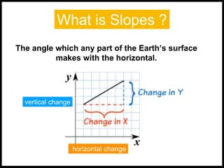
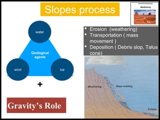
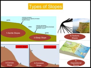
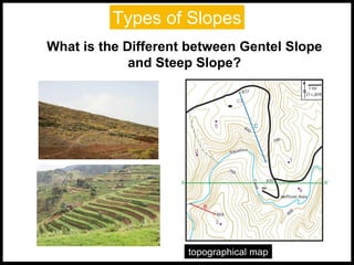
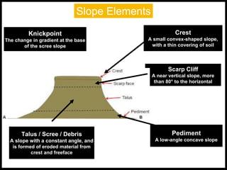
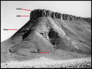
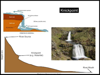
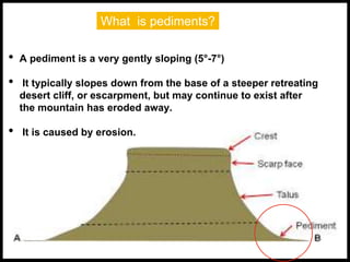
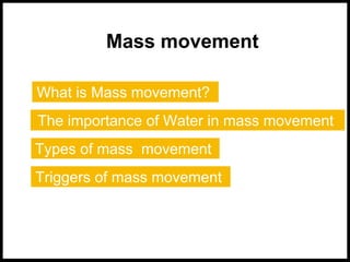
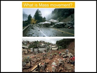
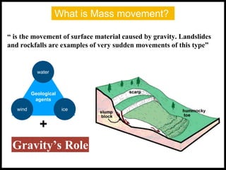
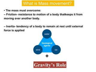
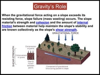
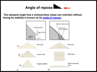
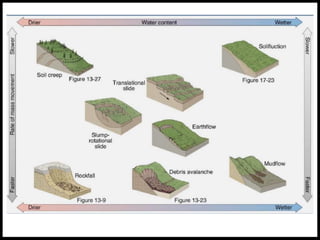
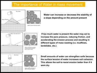
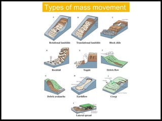
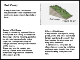
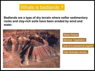
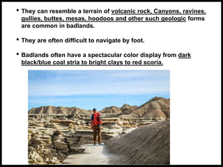
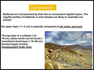
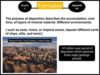
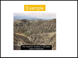
The document discusses various aspects of slopes and badlands in desert geomorphology. It defines slopes as the angle of the earth's surface relative to horizontal, and describes the key slope processes of erosion, transportation, and deposition driven by geological agents like water, ice, and wind. It outlines different slope types including gentle vs steep, convex, concave, depositional, and tectonic. Badlands are defined as dry terrain with softer sedimentary rocks and clay-rich soils eroded by wind and water, forming steep slopes with minimal vegetation. Mass movement is explained as the gravity-driven movement of surface material, with water playing an important role. Different types of mass movement are also defined such as soil creep, sol
Geologic time scale, Uniformitarianism, Catastrophic concept, Geomorphic process-agent cause and product, Hutton's concept, Davis Concept, Darwin's concept, Gilbert's concept
Geomorphology at a glance: Major landformsP.K. Mani
Geomorphology, Major landforms, Genetic landform classifications, Volcanic landforms, River Systems and Fluvial Landforms, Aeolian Landforms, Glacial Landforms
This topic includes representation of topography by various non mathematical and mathematical methods.
Pictorial method (Hachure lines, Hill shading)
Mathematical method (Spot heights,Bench marks, Trigonometrical stations, Layer tint or altitude tints, Contour lines )
Combination of different methods
This is first part of PowerPoint presentation on Geological Landforms. The landforms described in the slides are the ones that are most commonly found.
Contents:
1. Features and typical Landforms associated with an ideal fluvial cycle in a humid region.
2. Features found in arid regions
3. River Patterns
4. Drainage Patterns
Part - II of this PowerPoint presentation will be made available soon :)
Definition, classification & types of landslideTarikIslam9
General Information about Bangladesh
Bangladesh is consisted of a total land area of 147570 km² with hilly areas of 17,342 km² (8.5% of total area of Bangladesh).
Chattagram Hill tracts is the wide ranging hilly area in the southeastern part of the country. Rangamati, Bandarban and Khagrachari are three unique geographical and cultural landscape administrative districts in this region.
Landslides are a common hazard in the Chittagong Hill Districts (CHD) of Bangladesh. The communities that live on dangerous hill slopes in CHD repeatedly experience landslide hazards during the monsoon season, with casualties, economic losses and property damage.
Natural farming @ Dr. Siddhartha S. Jena.pptxsidjena70
A brief about organic farming/ Natural farming/ Zero budget natural farming/ Subash Palekar Natural farming which keeps us and environment safe and healthy. Next gen Agricultural practices of chemical free farming.
Micro RNA genes and their likely influence in rice (Oryza sativa L.) dynamic ...Open Access Research Paper
Micro RNAs (miRNAs) are small non-coding RNAs molecules having approximately 18-25 nucleotides, they are present in both plants and animals genomes. MiRNAs have diverse spatial expression patterns and regulate various developmental metabolisms, stress responses and other physiological processes. The dynamic gene expression playing major roles in phenotypic differences in organisms are believed to be controlled by miRNAs. Mutations in regions of regulatory factors, such as miRNA genes or transcription factors (TF) necessitated by dynamic environmental factors or pathogen infections, have tremendous effects on structure and expression of genes. The resultant novel gene products presents potential explanations for constant evolving desirable traits that have long been bred using conventional means, biotechnology or genetic engineering. Rice grain quality, yield, disease tolerance, climate-resilience and palatability properties are not exceptional to miRN Asmutations effects. There are new insights courtesy of high-throughput sequencing and improved proteomic techniques that organisms’ complexity and adaptations are highly contributed by miRNAs containing regulatory networks. This article aims to expound on how rice miRNAs could be driving evolution of traits and highlight the latest miRNA research progress. Moreover, the review accentuates miRNAs grey areas to be addressed and gives recommendations for further studies.
UNDERSTANDING WHAT GREEN WASHING IS!.pdfJulietMogola
Many companies today use green washing to lure the public into thinking they are conserving the environment but in real sense they are doing more harm. There have been such several cases from very big companies here in Kenya and also globally. This ranges from various sectors from manufacturing and goes to consumer products. Educating people on greenwashing will enable people to make better choices based on their analysis and not on what they see on marketing sites.
Artificial Reefs by Kuddle Life Foundation - May 2024punit537210
Situated in Pondicherry, India, Kuddle Life Foundation is a charitable, non-profit and non-governmental organization (NGO) dedicated to improving the living standards of coastal communities and simultaneously placing a strong emphasis on the protection of marine ecosystems.
One of the key areas we work in is Artificial Reefs. This presentation captures our journey so far and our learnings. We hope you get as excited about marine conservation and artificial reefs as we are.
Please visit our website: https://kuddlelife.org
Our Instagram channel:
@kuddlelifefoundation
Our Linkedin Page:
https://www.linkedin.com/company/kuddlelifefoundation/
and write to us if you have any questions:
info@kuddlelife.org
Characterization and the Kinetics of drying at the drying oven and with micro...Open Access Research Paper
The objective of this work is to contribute to valorization de Nephelium lappaceum by the characterization of kinetics of drying of seeds of Nephelium lappaceum. The seeds were dehydrated until a constant mass respectively in a drying oven and a microwawe oven. The temperatures and the powers of drying are respectively: 50, 60 and 70°C and 140, 280 and 420 W. The results show that the curves of drying of seeds of Nephelium lappaceum do not present a phase of constant kinetics. The coefficients of diffusion vary between 2.09.10-8 to 2.98. 10-8m-2/s in the interval of 50°C at 70°C and between 4.83×10-07 at 9.04×10-07 m-8/s for the powers going of 140 W with 420 W the relation between Arrhenius and a value of energy of activation of 16.49 kJ. mol-1 expressed the effect of the temperature on effective diffusivity.
Diabetes is a rapidly and serious health problem in Pakistan. This chronic condition is associated with serious long-term complications, including higher risk of heart disease and stroke. Aggressive treatment of hypertension and hyperlipideamia can result in a substantial reduction in cardiovascular events in patients with diabetes 1. Consequently pharmacist-led diabetes cardiovascular risk (DCVR) clinics have been established in both primary and secondary care sites in NHS Lothian during the past five years. An audit of the pharmaceutical care delivery at the clinics was conducted in order to evaluate practice and to standardize the pharmacists’ documentation of outcomes. Pharmaceutical care issues (PCI) and patient details were collected both prospectively and retrospectively from three DCVR clinics. The PCI`s were categorized according to a triangularised system consisting of multiple categories. These were ‘checks’, ‘changes’ (‘change in drug therapy process’ and ‘change in drug therapy’), ‘drug therapy problems’ and ‘quality assurance descriptors’ (‘timer perspective’ and ‘degree of change’). A verified medication assessment tool (MAT) for patients with chronic cardiovascular disease was applied to the patients from one of the clinics. The tool was used to quantify PCI`s and pharmacist actions that were centered on implementing or enforcing clinical guideline standards. A database was developed to be used as an assessment tool and to standardize the documentation of achievement of outcomes. Feedback on the audit of the pharmaceutical care delivery and the database was received from the DCVR clinic pharmacist at a focus group meeting.
Willie Nelson Net Worth: A Journey Through Music, Movies, and Business Venturesgreendigital
Willie Nelson is a name that resonates within the world of music and entertainment. Known for his unique voice, and masterful guitar skills. and an extraordinary career spanning several decades. Nelson has become a legend in the country music scene. But, his influence extends far beyond the realm of music. with ventures in acting, writing, activism, and business. This comprehensive article delves into Willie Nelson net worth. exploring the various facets of his career that have contributed to his large fortune.
Follow us on: Pinterest
Introduction
Willie Nelson net worth is a testament to his enduring influence and success in many fields. Born on April 29, 1933, in Abbott, Texas. Nelson's journey from a humble beginning to becoming one of the most iconic figures in American music is nothing short of inspirational. His net worth, which estimated to be around $25 million as of 2024. reflects a career that is as diverse as it is prolific.
Early Life and Musical Beginnings
Humble Origins
Willie Hugh Nelson was born during the Great Depression. a time of significant economic hardship in the United States. Raised by his grandparents. Nelson found solace and inspiration in music from an early age. His grandmother taught him to play the guitar. setting the stage for what would become an illustrious career.
First Steps in Music
Nelson's initial foray into the music industry was fraught with challenges. He moved to Nashville, Tennessee, to pursue his dreams, but success did not come . Working as a songwriter, Nelson penned hits for other artists. which helped him gain a foothold in the competitive music scene. His songwriting skills contributed to his early earnings. laying the foundation for his net worth.
Rise to Stardom
Breakthrough Albums
The 1970s marked a turning point in Willie Nelson's career. His albums "Shotgun Willie" (1973), "Red Headed Stranger" (1975). and "Stardust" (1978) received critical acclaim and commercial success. These albums not only solidified his position in the country music genre. but also introduced his music to a broader audience. The success of these albums played a crucial role in boosting Willie Nelson net worth.
Iconic Songs
Willie Nelson net worth is also attributed to his extensive catalog of hit songs. Tracks like "Blue Eyes Crying in the Rain," "On the Road Again," and "Always on My Mind" have become timeless classics. These songs have not only earned Nelson large royalties but have also ensured his continued relevance in the music industry.
Acting and Film Career
Hollywood Ventures
In addition to his music career, Willie Nelson has also made a mark in Hollywood. His distinctive personality and on-screen presence have landed him roles in several films and television shows. Notable appearances include roles in "The Electric Horseman" (1979), "Honeysuckle Rose" (1980), and "Barbarosa" (1982). These acting gigs have added a significant amount to Willie Nelson net worth.
Television Appearances
Nelson's char
WRI’s brand new “Food Service Playbook for Promoting Sustainable Food Choices” gives food service operators the very latest strategies for creating dining environments that empower consumers to choose sustainable, plant-rich dishes. This research builds off our first guide for food service, now with industry experience and insights from nearly 350 academic trials.
7. Types of Slopes
What is the Different between Gentel Slope
and Steep Slope?
topographical map
8. Types of Slopes
1. Gentle Slope
A slope with contour lines
spread far apart from each
other. This even spacing
is maintained in both up
and down slope.
2. Steep Slope
A slope represented with
contour lines close to each
other on a topographical map.
topographical map
9. Types of Slopes
3- Convex Slope
4- Concave Slope
A slope which
becomes progressively
steeper downhill
A slope which
becomes
progressively steeper
uphill
10. 5- Depositional Slopes
Deposits of weather material build up to form inclined
surfaces, mounds and hills when an agent of erosion (e.g.
wind, water or ice)
Types of Slopes
Examples
- alluvial fans
- alluvial cones
- deltas
- -sand dunes.
11. 6-Tectonic Slopes
These are formed through ”internal forces“ that result in the )
folding, warping and faulting( of rock masses or layers.
Anticlines and synclines horsts and graben
Types of Slopes
12. Slope Elements
Crest
A small convex-shaped slope,
with a thin covering of soil
Scarp Cliff
A near vertical slope, more
than 80° to the horizontal
Talus / Scree / Debris
A slope with a constant angle, and
is formed of eroded material from
crest and freeface
Knickpoint
The change in gradient at the base
of the scree slope
Pediment
A low-angle concave slope
16. What is pediments?
• A pediment is a very gently sloping (5°-7°)
• It typically slopes down from the base of a steeper retreating
desert cliff, or escarpment, but may continue to exist after
the mountain has eroded away.
• It is caused by erosion.
17. What is pediments?
It develops when sheets of running water wash over it in
intense rainfall events.
18. Three formational zones are recognized for
pediments:
• An inner most zone of mountainous uplands that have near
vertical erosion
• An intermediate zone which is the pediment beyond the
mountain front.
• An outer zone which extends beyond the pediment and is a
zone of deposition.
Coalescence of pediments over a large area results in a
pediplain.
formational zones of pediments
19. Processes responsible for carving pediments
• Erosion by a stream.
• Sheet erosion
"The removal of thin layers of surface material more or less
evenly from an extensive area of gently sloping land, by broad
continuous sheets of running water rather than by stream flowing
in well defined channels
20. •Rill erosion
"The development of numerous minute closely spaced channels result
• Mountain-front retreating by weathering
Processes responsible for carving pediments
22. A small, rounded hill, knob, ridge, or mini mountain
that rises abruptly from relatively flat surroundings.
- Inselbergs are generally erosional remnants.
- Often, inselbergs are composed of harder igneous rock (such as
granite)that is more resistant to erosion.
What is Inselbergs?
23. Example
Uluru or Ayer's Rock inselberg in Australia.
Photo courtesy of Gillian.
Steep-sided monument. Western USA, Fall 2005.
24. Mass movement
What is Mass movement?
The importance of Water in mass movement
Types of mass movement
Triggers of mass movement
26. What is Mass movement?
“ is the movement of surface material caused by gravity. Landslides
and rockfalls are examples of very sudden movements of this type”
Geological
agents
water
icewind
+
Gravity’s Role
27. • The mass must overcome:
– Friction- resistance to motion of a body thatkeeps it from
moving over another body.
– Inertia- tendency of a body to remain at rest until external
force is applied
Geological
agents
water
icewind
+
Gravity’s Role
What is Mass movement?
28. When the gravitational force acting on a slope exceeds its
resisting force, slope failure (mass wasting) occurs. The slope
material's strength and cohesion and the amount of internal
friction between material help maintain the slope's stability and
are known collectively as the slope's shear strength.
Gravity’s Role
29. The steepest angle that a cohesionless slope can maintain without
losing its stability is known as its angle of repose.
Angle of repose
30.
31. The importance of Water in mass movement
Water can increase or decrease the stability of
a slope depending on the amount present
Small amounts of water can strengthen soils because
the surface tension of water increases soil cohesion.
This allows the soil to resist erosion better than if it
were dry
If too much water is present the water may act to
increase the pore pressure, reducing friction, and
accelerating the erosion process and resulting in
different types of mass wasting (i.e. mudflows,
landslides, etc.)
33. Soil Creep
Creep is the slow, continuous
movement of soil or unconsolidated
sediments over extended periods of
time.
Causes of Soil Creep
Creep is caused by repeated freeze-
thaw cycles that slowly inch material
downslope (during freezing, particles
are elevated perpendicular to the
slope, but during thaws they fall
straight down to a new position lower
on the slope).
Creep can also be caused by a
buildup of pore water that allows
material to begin to flow under the
influence of gravity.
Effects of Soil Creep
Creep causes fence posts, utility
poles, walls, and other structures
to lean over time. Eventually the
lean topples the structures and
they must be rebuilt.
In some cases, creep can be
slowed or prevented by installing
drainage pipes in soils that drain
them and keep pore pressures
low.
34. Solifluction
It is the down slope movement of soil over a permanently frozen
subsurface. Solifluction is common on slopes underlain by permafrost
(permanently frozen sub – soil).
35. Landslides
A landslide is a movement of rock or debris down a
slope along one or more distinct surfaces. Landslides
range in speed from 1 m/day to as much as 300 km/hr.
36. Rockfalls
Rockfall (free fall of rock) is an extremely rapid process and occurs without
warning.
Rockfall is typically the result of frost wedging.
37. A mudflow or mud flow :
is a form of mass wasting involving "very rapid to extremely
rapid surging flow"of debris that has become partially or fully
liquified by the addition of significant amounts of water to the
source material.
38. Slumps
The sliding of material along a curved surface called a rotational slide or slump.
A common cause of slumping is erosion at the base of a slope. For example,
coastal storm
waves erode cliff bases, removing supporting material.
The slump block rotates downward, producing a scarp (cliff) at the top of the
slope.
39. Triggers of mass movement
Soil and regolith remain on a hillslope only while the gravitational forces are unable
to overcome the frictional forces keeping the material in place.
Factors that reduce the frictional resistance relative to the downslope forces,
and thus initiate slope movement, can include:
earthquakes
increased overburden
from structures
increased soil moisture
reduction of roots holding
the soil to bedrock
undercutting of the
slope by excavation or
erosion
weathering by frost heave
bioturbation
41. Whats is badlands ?
Badlands are a type of dry terrain where softer sedimentary
rocks and clay-rich soils have been eroded by wind and
water.
Steep Slopes
Minimal Vegetation
lack of a substantial regolith
high drainage density.
42. • They can resemble a terrain of volcanic rock, Canyons, ravines,
gullies, buttes, mesas, hoodoos and other such geologic forms
are common in badlands.
• They are often difficult to navigate by foot.
• Badlands often have a spectacular color display from dark
black/blue coal stria to bright clays to red scoria.
43. Composition
Badlands are characterized by their thin to nonexistent regolith layers. The
regolith profiles of badlands in arid climates are likely to resemble one
another
the upper layer (~1–5 cm) is typically composed of silt, shale, and sand
The top layer is a sublayer (~5–
10 cm), below which can be found a
transitional shard layer (~10–40 cm),
formed largely of loose
disaggregated shale chips
44. Formation
The process of deposition describes the accumulation, over
time, of layers of mineral material. Different environments.
( such as seas, rivers, or tropical zones, deposit different sorts
of clays, silts, and sand.)
47-million year period of
deposition which spanned
three major geologic
periods
depositi
on
Erosio
n.
National Park, South Dakota, United States
i will talk about Slopes and The parts , types and the process thats happen in slopes
انسيل بيرغس
Slope compares the vertical change (the rise) to the horizontal change (the run) when moving from one fixed point to another along the line
انقل
هورزانتل
and of cours Slope process refers to the active agents which bring about changes in landforms, for example the impact of falling raindrops (water) or running water (River sources) or (ice) .
And we will talk about slopes process with details in “Mass Movment"
Gentle Slope
A slope with contour lines spread far apart from each other.
This even spacing is maintained in both up and down slope.
2. Steep Slope
A slope represented with contour lines close to each other on a topographical map..
١Gentle Slope
A slope with contour lines spread far apart from each other. This even spacing is maintained in both up and down slope.
2. Steep Slope
A slope represented with contour lines close to each other on a topographical map.
1-Convex Slope
On a map the contour lines will be spaced closer together with a decline in height above sea-level.
2-Concave Slope
. On a map the Contour lines will be spaced closer with an increase in height above sea-level.
which has lost its energy of moshen, lays down its load in a pretecelar place.
Examples
- alluvial fans
- alluvial cones
-deltas
-sand dunes.
anteclians and seenclians , are formed -when layers of rock are folded.
horsts and gruben are formed when blocks of land rise or fall in relation to each other when faulting occours.
As we can see the Slopes Elements in nature
Knickpoint
The change in gradient at the base of the scree slope
as we can see in this circle the chang in gradient near of base
The engle
Low angle,
It is typically a concave surface gently sloping away from mountainous desert areas.
Slope is not uniform- steeper close to the talus slope.
Pediment increases as the slope increases backwards due to scarp recession
It develops when sheets of running water (laminar sheet flows) wash over it in intense rainfall events.
It may be thinly covered with fluvial gravel that has washed over it from the foot of mountains produced by cliff retreat erosion.
It is typically a concave surface gently sloping away from mountainous desert areas.
- However, inselbergs may also form in sedimentary rocks.
How process affects slope morphology
mass movement and morphology
• creep leads to the development of convex upward slope segments
• solifluction, slumps, and flows commonly result in concave upward profiles at their heads and convex toes of colluvium
• rock fall forms a talus (scree slope)beneath a free face (cliff)
o slope of talus is governed by:
♣ angularity of sediment
♣ Rate of rock fall vs. rate of weathering and erosion of talus
o Pediment surfaces that lack significant debris beneath the free face develops because talus is weathered and removed faster than it is produced
Effects of water
• surface flow (Horton overland flow, or slopewash, and channel flow):
o aids the development of concave upward profiles in valleys and
o convex upward profiles along divides
• subsurface flow (downward percolation, throughflow and groundwater flow)
o aids in elluviation (minor?mechanism of slope decline)
o aids in the formation of earthflows and solifluction
o may lead to surface channel formation by piping (sapping).
• The mass must overcome:
– Friction- resistance to motion of a body that
keeps it from moving over another body, and
– Inertia- tendency of a body to remain at rest until external force is applied
When a slope made of loose material possesses this angle, its shear strength perfectly counterbalances the force of gravity acting upon it.
Angle of Repose The maximum angle at which slope material can be inclined without moving downslope It is a critical value for stability for a particular slope If the actual slope angle is less than the angle of repose, the slope is stable If the actual slope angle is greater than the angle of repose, mass movement can occur The angle of repose changes as slope conditions (such as soil moisture) changes The angle of repose can never be exceeded Angle of repose can decrease under severe motion (earthquakes) or saturation
Mass wasting may occur at a very slow rate, particularly in areas that are very dry or those areas that receive sufficient rainfall such that vegetation has stabilized the surface. It may also occur at very high speed, such as in rockslides or landslides, with disastrous consequences, both immediate and delayed, e.g., resulting from the formation of landslide dams.
Factors that change the potential of mass wasting include: change in slope angle, weakening of material by weathering, increased water content; changes in vegetation cover, and overloading.
Volcano flanks can become over-steep resulting in instability and mass wasting. This is now a recognised part of the growth of all active volcanoes. It is seen on submarine as well as surface volcanoes: Loihi in the Hawaiian volcanic chain and Kick 'em Jenny in the Caribbean volcanic arc are two submarine volcanoes that are known to undergo mass wasting. The failure of the northern flank of Mount St Helens in 1980 showed how rapidly volcanic flanks can deform and fail.
. A good example of this is to think of a sand castle. Water must be mixed with sand in order for the castle to keep its shape. If too much water is added the sand washes away, if not enough water is added the sand falls and cannot keep its shape. Water also increases the mass of the soil, this is important because an increase in mass means that there will be an increase in velocity if mass wasting is triggered. Saturated water, however, eases the process of mass wasting in that the rock and soil debris are easily washed down-slope
ypes of mass wasting
Based on how the soil, regolith or rock moves downslope as a whole, mass movements can be broadly classified as Slow Movements, Rapid Movements and Landslides.
Creeps[edit]
Soil creep is a long term process (slow movements). The combination of small movements of soil or rock in different directions over time are directed by gravity gradually downslope. The steeper the slope, the faster the creep. The creep makes trees and shrubs curve to maintain their perpendicularity, and they can trigger landslides if they lose their root footing. The surface soil can migrate under the influence of cycles of freezing and thawing, or hot and cold temperatures, inching its way towards the bottom of the slope forming terracettes. This happens at a rate that is not noticeable to the naked eye.
Landslides[edit]
A landslide, also called a landslip, is a rapid movement of a large mass of earth and rocks down a hill or a mountainside. Little or no flowage of the materials occurs on a given slope until heavy rain and resultant lubrication by the same rainwater facilitate the movement of the materials, causing a landslide to occur. The common forms of landslides are slump, debris slide, rock slide, rock fall, debris fall and avalanche.
Flows[edit]
See also Landslide classification § Flows.
Movement of soil and regolith that more resembles fluid behavior is called a flow. These include avalanches, mudflows, debris flows, earth flow, lahars and sturzstroms. Water, air and ice are often involved in enabling fluidlike motion of the material.
Slump[edit]
A slipping of coherent rock material along the curved surface of a decline. Slumps involve a mass of soil or other material sliding along a curved surface (shaped like a spoon). It forms a small, crescent-shaped cliff, or abrupt scarp at the top end of the slope. There can be more than one scarp down the slope.
Falls[edit]
A fall, including rockfall, occurs where regolith cascades down a slope, but is not of sufficient volume or viscosity to behave as a flow. Falls are promoted in rocks which are characterised by presence of vertical cracks. Falls can result from undercutting by running water as well as from undercutting by waves. They usually occur at very steep slopes such as a cliff face. The rock material may be loosened by earthquakes, rain, plant-root wedging, and expanding ice, among other things. The accumulation of rock material that has fallen and resides at the base of the structure is known as talus
.
. Types of Mass Movements Rockfall Loose rocks fall through the air, accumulate in a talus cone High angle of repose Debris avalanche Rocks, debris and soil Extremely high velocity Water and ice often fluidize debris Landslide Unsaturated mass of bedrock and regolith that moves suddenly and rapidly Rotational slumping Translational slides Flows earthflow mudflow Creep: a persistent movement of soil down slope
. 9. Rockfall
. 10. Rotational block slump
. 11. Debris avalanche
. 12. Debris avalanche
. 13. Soil Creep
During the summer when the upper permafrost is activated, the waterlogged soil mass slowly moves down slope to form solifluction lobes or terraces.
Frost wedging is a process where water enters cracks in rocks, freezes, expands, and breaks the
rock apart.
تريجلز
They are characterized by steep slopes, minimal vegetation, lack of a substantial regolith, and high drainage density.
Draneg
ريجليث
سيلت – شيل –
Desagregated
Some badlands have no regolith layer whatsoever, capping instead in bare rock such as
sandstone. Others have a regolith with a clay veneer, and still others have a biological crut of algae or lichens.
n addition to lacking significant regolith, they also lack much vegetation. The lack of vegetation could very well be a result of the lack of a substantial regolith.[3]
The formation of badlands is a result of two processes: deposition and erosion.
The process of deposition describes the accumulation, over time, of layers of mineral material. Different environments.
( such as seas, rivers, or tropical zones, deposit different sorts of clays, silts, and sand.)For instance, the badlands formations in Badlands National Park, South Dakota, United States underwent a 47-million year period of deposition which spanned three major geologic periods (the Cretaceous Period, the Late Eocene, and the Oligocene Epochs), resulting in clear, distinct layers of sediment[4] which serve as a dramatic display of the law of superposition. Once the deposited sediments have solidified, the sedimentary material becomes subject to erosion. It is sometimes erroneously taught that badlands erode at a steady rate of about one inch per year.[5] In actuality, the precise processes by which the erosion responses take place vary depending on the precise interbedding of the sedimentary material.[6] In 2010, researchers at Badlands National Park initiated a three-year project to learn more about the actual erosion rate of the specific badlands found in that park.[5]
Some of the best-known badland formations can be found in Canada and the United States. In the U.S., Makoshika State Park in Montana and Badlands National Park in South Dakota together form a series of extensive badland formations. Among the Henry Mountains area, about 1500m above sea level, Cretaceous and Jurassic aged shales are exposed. Theodore Roosevelt National Park is a United States National Park composed of three geographically separated areas of badlands in western North Dakota and was named for U.S. President Theodore Roosevelt. Another popular area of badland formations is Toadstool Geologic Park in the Oglala National Grassland of northwestern Nebraska. Dinosaur National Monument in Colorado and Utah are also badlands settings. A small badland called Hell's Half-Acre is present in Natrona County, Wyoming. Additional badlands also exist in various places throughout southwest Wyoming, such as near Pinedale and in the Bridger Valley near the towns of Lyman and Mountain View, near the high Uintah Mountains
El Malpais National Monument in western New Mexico is named after the Spanish word malpaís, meaning bad lands.
The Big Muddy Badlands in Saskatchewan, Canada, gained notoriety as a hideout for outlaws. There is a large badland area in Alberta, Canada, particularly in the valley of the Red Deer River, where Dinosaur Provincial Park is located, as well as in Drumheller, where The Royal Tyrrell Museum of Palaeontology is located.
The "Calanchi" of Aliano, in the Italian region of Basilicata
A well-known badlands formation in New Zealand – the Putangirua Pinnacles, formed by the erosion of the conglomerate of an old alluvial fan – is located at the head of a small valley near the southern tip of the North Island.
Other badlands can be found in Italy, known as "Calanchi". Some examples include Aliano, Basilicata, and Val d'Orcia, Tuscany.
The Bardenas Reales near Tudela, Navarre, and the Tabernas Desert in Tabernas, Almería, and possible Los Monegros in Aragon, all of them in Spain, are examples in Europe.
The Valle de la Luna ("Valley of the Moon") is one of many examples of badland formations in midwestern Argentina. This geologic formation is the only place in the world where nearly all of the Triassic is represented in an undisturbed sequence of rock deposits.
The badlands of the Gutingkeng Formation in southern Taiwan are the only example of badlands in a tropical climate. The formation has a thickness of 3–4 km and covers over 100,000 hectares.[citation needed]
Although most badland scenery is natural, there are some examples produced by mining, such as the Roman gold mine of Las Médulas in northern Spain. An example of badlands produced by poor farming practices is the Cheltenham Badlands in Caledon, Ontario.