The document discusses geology, focusing on the study of the Earth's structure, plate tectonics, and the historical perspectives of geological change, including catastrophism and uniformitarianism. It outlines the movement of Earth's lithospheric plates and the theory of continental drift, emphasizing the evidence supporting the idea that continents were once joined as a supercontinent called Pangaea. Additionally, it touches on the geological processes and forces driving plate movements, such as convection cells and rifting.


![HISTORY AND DEVELOPMENT OF THE PLATE
1596
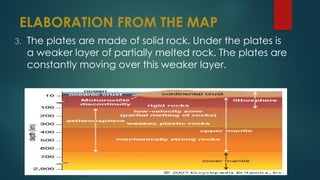
Dutch map maker Abraham Ortelius in his
work Thesaurus Geographicus.
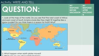
Ortelius suggested that the Americas were "torn
away from Europe and Africa . . . by earthquakes
and floods" and went on to say: "The vestiges of
the rupture reveal themselves, if someone brings
forward a map of the world and considers
carefully the coasts of the three [continents].](https://image.slidesharecdn.com/science1stday-241117033212-f36d5db1/85/SCIENCE-10-CONTINENTAL-DRIFT-THEORIES-15-320.jpg)