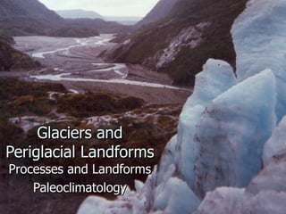
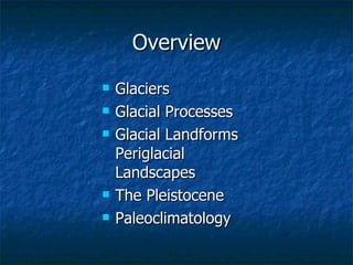
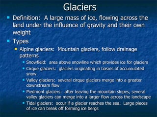
Glaciers and Periglacial Landforms Processes and Landforms Paleoclimatology
Overview Glaciers Glacial Processes Glacial Landforms Periglacial Landscapes The Pleistocene Paleoclimatology
Objectives Describe the different forms of glaciers in terms of the similarity of their formation and differences in spatial extent Explain the interrelationships between the processes of glacier formation, and those of glacial motion Relate glacial motion to the geomorphological themes of erosion, transportation and deposition, and describe the landforms associated with each Identify various glacial landforms and describe the processes that created them Describe the features and processes of periglacial landscapes Describe some of the significant features of the Pleistocene Identify major sources of climatic variability and explain how they contribute to climate change
Glaciers Definition:  A large mass of ice, flowing across the land under the influence of gravity and their own weight Types Alpine glaciers:  Mountain glaciers, follow drainage patterns Snowfield:  area above snowline which provides ice for glaciers Cirque glaciers:  glaciers originating in basins of accumulated snow  Valley glaciers:  several cirque glaciers merge into a greater downstream flow Piedmont glaciers:  after leaving the mountain slopes, several valley glaciers can merge into a larger flow across the landscape Tidal glaciers:  occur if a glacier reaches the sea.  Large pieces of ice can break off forming ice bergs
 
 
Continental glaciers:  continuous expanses of solid ice that subsume broad landscapes, including drainage systems and surrounding peaks Ice sheets cover entire continental masses Antarctica (90% coverage) Greenland (81% coverage) ice mass can achieve depths of 2000 – 3000 meters actual landmasses can be isostatically depressed below sea level Ice caps covers an area less than 50,000 sq. km. and typically has a circular shape Ice fields Ice fills elongated valleys along mountain ranges


Glacial Processes Formation Zone of Accumulation:  area above snowline where snow exists year-round Snow accumulates in basins and becomes compacted under its own weight Snow becomes firn (compacted, granular snow) Firn becomes glacial ice (exhibits strata from accumulation)
 
Mass Balance Above the snow line, in the Zone of Accumulation, mass is added to the glacier Below the snow line, the glacial ice can melt, sublimate, deflate in the wind, or break off the main glacier Ablation or Waste are terms used to describe these losses Zone of Ablation:  the area below snowline where mass is lost from the glacier Mass balance refers to the rate of accumulation compared to the rate of ablation Positive balance:  accumulation greater than ablation; glacier advances Negative balance:  ablation exceeds accumulation; glacier retreats With current climate change, the world’s glaciers are largely in retreat When rates of accumulation and ablation are equal, glacial movement continues to occur, but there is no net advance or retreat


Glacial Movement Simultaneous sliding and oozing motion Frictional movement glacial ice rubs against bedrock on the sides and bottom of the valley Abrasion and Plucking (erosional process) Lateral and medial moraines (transportation features) Plastic movement glacier moves faster internally than along frictional edges Causes cracks (crevasses) to form on the surface Surges Glaciers have been known to move several meters in one day requires either large accumulations of mass, or lubricating meltwaters along the sides and bottoms
 
 
Glacial Landforms Erosion Plucking Abrasion Transportation Surface load Suspended load (englacial transport) Along margins Deposition Occurs as a result of ablation Melting and outwash sort transported material by mass and texture Larger objects deposited in situ Smaller sediments carried out by outwash


Erosional Features of Alpine Glaciers Modified upslope drainage U-shaped valleys Horns Ar ê tes Cirques Hanging valleys Tarns and paternoster lakes Fjords


Depositional Features of Alpine Glaciers Glacial Drift Deposits of transported material (cobbles and finer sediment) Stratified drift:  deposited by melt waters, sorted by size Glacial till:  unsorted material deposited in place by ice Moraines Deposition of glacial till by retreating glaciers Rapid ablation causes till to be dispersed over a surface, creating a  ground moraine  or  till plain Slowing retreats (punctuated by periods of equilibrium) concentrate deposits of till terminal moraines mark the farthest extent of glacial advance recessional moraines mark periods of slowing retreat during periods of general retreat


Features of Continental Glaciation Erosional features deranged drainage roche moutonn é e Depositional features Terminal and recessional moraines Till plain, outwash plain Eskers Kettles Kames Drumlins


Periglacial Landscapes Features of Subarctic and Polar (tundra) climates that are not directly related to glaciation Processes Physical weathering Mass movement Climate Soil Features Permafrost frost action ground ice
Permafrost develops after soil and rock have been below freezing for at least 2 consecutive years Independent of moisture content of the soil snow cover insulates the ground, preventing heat loss Continuous and Discontinuous Zones of permafrost Continuous Zone Permafrost occurs everywhere, continuously, throughout this region Occurs pole-ward of the –7 o C mean annual temperature isotherm Discontinuous Zone Occurs equator-ward of the –7 o C mean annual temperature isotherm Permafrost becomes patchy and disconnected, becoming sparser at lower latitudes (mixed landscape of cryotic and noncryotic soil) Patches occur on slopes facing away from the sun (North slopes in N. Hemisphere), cold soil, or areas not blanketed by snow
 
 
Permafrost behavior Active layer:  exposed to daily and seasonal freezes and thaws active layer thickens with increases in temperature Thawing releases carbon dioxide into the air Taliks areas of noncryotic soil within areas of continuous permafrost taliks form links with groundwater, permafrost disrupts these links
Ground Ice and Frozen Ground Refers to frozen subsurface water Pore Ice Lenses and Veins Segregated Ice Intrusive Ice Wedge Ice Frost Action expansion of water as it freezes creates physical forces Shatters rock, creating block fields or felsenmeer perturbs the soils Frost heaving Frost thrusting cryoturbation Ice wedging
Landforms Pingos:  frozen injected artesian water, forming a circular mound, sometimes up to 60 m in height Palsas:  Mounds of peat with ice lenses (1 – 10 m) Patterned ground:  heaving and thrusting of the soil sorts the particles according to texture, with accumulations in wedge cracks, forming polygonal patterns on the ground Hillslope Processes Active layer becomes saturated with water during thaw cycles, and a slow downhill flow can occur solifluction, gelifluction Thermokarst landscapes Formed from melting ground ice with poor drainage cave-ins, bogs, depressions, standing water and small lakes not related to carbonated Karst topography


The Pleistocene 1.8 million to 10,000 years ago Ice sheets and glaciers covered 1/3 of Earth’s surface Periglacial regions occupied another 40%  The longest prolonged cold period in Earth’s history Ice Age:  period of prolonged cold marked by significant periods of glacial advance glacials:  90,000 years interglacials:  10,000 years Pleistocene included 18 glacials


Features Formation of the Great Lakes Drainage systems enlarged by glacial action Two periods of advance and retreat Charging of the Great Plains Aquifer Land Bridges Lower temperatures caused more of Earth’s water to be tied up in ice Sea levels were 100 meters lower than today Exposed land, linking several continents, allowing for movement of species, especially humans Bering Straits Land Bridge England and France Australia, New Guinea and Indonesia Paleolakes Advance of glaciers caused an advance of polar conditions, subpolar lows and polar jet stream, bringing wetter conditions further south Pluvials Interpluvials Much of the American Southwest exhibited large lakes that are now dry
 
 
Paleoclimatology The study of past climates and their change over time Ice cores Ocean sediments pollen records correlation of coral productivity to sea-level changes Humans evolved during the coldest parts of Earth’s history Recent Fluctuations Medieval Warm Period:  800 – 1200 Little Ice Age:  1200 – 1350, 1800 - 1900
 
Mechanisms of Climate Change Variations in Earth-Sun relations 100,000 year cycle in variation of the shape of Earth’s orbit 17.7 million km variation in Earth-Sun distance 26,000 year cycle in precession affects axial parallelism 40,000 year cycle in axial tilt varies between 22 o  and 24 o Solar variability:  variation in solar output Tectonics:  movement of continents between latitudes Atmospheric factors Volcanic eruptions Fluctuations in CO 2  content Oceanic Circulation Formation of the Isthmus of Panama 3 million years ago altered the patterns of ocean currents, area of upwelling, and distribution of hot and cold ocean waters


Glaciers

  • 1.
    Glaciers and PeriglacialLandforms Processes and Landforms Paleoclimatology
  • 2.
    Overview Glaciers GlacialProcesses Glacial Landforms Periglacial Landscapes The Pleistocene Paleoclimatology
  • 3.
    Objectives Describe thedifferent forms of glaciers in terms of the similarity of their formation and differences in spatial extent Explain the interrelationships between the processes of glacier formation, and those of glacial motion Relate glacial motion to the geomorphological themes of erosion, transportation and deposition, and describe the landforms associated with each Identify various glacial landforms and describe the processes that created them Describe the features and processes of periglacial landscapes Describe some of the significant features of the Pleistocene Identify major sources of climatic variability and explain how they contribute to climate change
  • 4.
    Glaciers Definition: A large mass of ice, flowing across the land under the influence of gravity and their own weight Types Alpine glaciers: Mountain glaciers, follow drainage patterns Snowfield: area above snowline which provides ice for glaciers Cirque glaciers: glaciers originating in basins of accumulated snow Valley glaciers: several cirque glaciers merge into a greater downstream flow Piedmont glaciers: after leaving the mountain slopes, several valley glaciers can merge into a larger flow across the landscape Tidal glaciers: occur if a glacier reaches the sea. Large pieces of ice can break off forming ice bergs
  • 5.
  • 6.
  • 7.
    Continental glaciers: continuous expanses of solid ice that subsume broad landscapes, including drainage systems and surrounding peaks Ice sheets cover entire continental masses Antarctica (90% coverage) Greenland (81% coverage) ice mass can achieve depths of 2000 – 3000 meters actual landmasses can be isostatically depressed below sea level Ice caps covers an area less than 50,000 sq. km. and typically has a circular shape Ice fields Ice fills elongated valleys along mountain ranges
  • 8.
  • 9.
  • 10.
  • 11.
    Glacial Processes FormationZone of Accumulation: area above snowline where snow exists year-round Snow accumulates in basins and becomes compacted under its own weight Snow becomes firn (compacted, granular snow) Firn becomes glacial ice (exhibits strata from accumulation)
  • 12.
  • 13.
    Mass Balance Abovethe snow line, in the Zone of Accumulation, mass is added to the glacier Below the snow line, the glacial ice can melt, sublimate, deflate in the wind, or break off the main glacier Ablation or Waste are terms used to describe these losses Zone of Ablation: the area below snowline where mass is lost from the glacier Mass balance refers to the rate of accumulation compared to the rate of ablation Positive balance: accumulation greater than ablation; glacier advances Negative balance: ablation exceeds accumulation; glacier retreats With current climate change, the world’s glaciers are largely in retreat When rates of accumulation and ablation are equal, glacial movement continues to occur, but there is no net advance or retreat
  • 14.
  • 15.
  • 16.
  • 17.
    Glacial Movement Simultaneoussliding and oozing motion Frictional movement glacial ice rubs against bedrock on the sides and bottom of the valley Abrasion and Plucking (erosional process) Lateral and medial moraines (transportation features) Plastic movement glacier moves faster internally than along frictional edges Causes cracks (crevasses) to form on the surface Surges Glaciers have been known to move several meters in one day requires either large accumulations of mass, or lubricating meltwaters along the sides and bottoms
  • 18.
  • 19.
  • 20.
    Glacial Landforms ErosionPlucking Abrasion Transportation Surface load Suspended load (englacial transport) Along margins Deposition Occurs as a result of ablation Melting and outwash sort transported material by mass and texture Larger objects deposited in situ Smaller sediments carried out by outwash
  • 21.
  • 22.
  • 23.
  • 24.
  • 25.
  • 26.
    Erosional Features ofAlpine Glaciers Modified upslope drainage U-shaped valleys Horns Ar ê tes Cirques Hanging valleys Tarns and paternoster lakes Fjords
  • 27.
  • 28.
  • 29.
  • 30.
  • 31.
  • 32.
  • 33.
  • 34.
  • 35.
  • 36.
  • 37.
  • 38.
  • 39.
  • 40.
  • 41.
  • 42.
  • 43.
  • 44.
  • 45.
  • 46.
  • 47.
  • 48.
  • 49.
  • 50.
    Depositional Features ofAlpine Glaciers Glacial Drift Deposits of transported material (cobbles and finer sediment) Stratified drift: deposited by melt waters, sorted by size Glacial till: unsorted material deposited in place by ice Moraines Deposition of glacial till by retreating glaciers Rapid ablation causes till to be dispersed over a surface, creating a ground moraine or till plain Slowing retreats (punctuated by periods of equilibrium) concentrate deposits of till terminal moraines mark the farthest extent of glacial advance recessional moraines mark periods of slowing retreat during periods of general retreat
  • 51.
  • 52.
  • 53.
  • 54.
    Features of ContinentalGlaciation Erosional features deranged drainage roche moutonn é e Depositional features Terminal and recessional moraines Till plain, outwash plain Eskers Kettles Kames Drumlins
  • 55.
  • 56.
  • 57.
  • 58.
  • 59.
  • 60.
  • 61.
  • 62.
  • 63.
    Periglacial Landscapes Featuresof Subarctic and Polar (tundra) climates that are not directly related to glaciation Processes Physical weathering Mass movement Climate Soil Features Permafrost frost action ground ice
  • 64.
    Permafrost develops aftersoil and rock have been below freezing for at least 2 consecutive years Independent of moisture content of the soil snow cover insulates the ground, preventing heat loss Continuous and Discontinuous Zones of permafrost Continuous Zone Permafrost occurs everywhere, continuously, throughout this region Occurs pole-ward of the –7 o C mean annual temperature isotherm Discontinuous Zone Occurs equator-ward of the –7 o C mean annual temperature isotherm Permafrost becomes patchy and disconnected, becoming sparser at lower latitudes (mixed landscape of cryotic and noncryotic soil) Patches occur on slopes facing away from the sun (North slopes in N. Hemisphere), cold soil, or areas not blanketed by snow
  • 65.
  • 66.
  • 67.
    Permafrost behavior Activelayer: exposed to daily and seasonal freezes and thaws active layer thickens with increases in temperature Thawing releases carbon dioxide into the air Taliks areas of noncryotic soil within areas of continuous permafrost taliks form links with groundwater, permafrost disrupts these links
  • 68.
    Ground Ice andFrozen Ground Refers to frozen subsurface water Pore Ice Lenses and Veins Segregated Ice Intrusive Ice Wedge Ice Frost Action expansion of water as it freezes creates physical forces Shatters rock, creating block fields or felsenmeer perturbs the soils Frost heaving Frost thrusting cryoturbation Ice wedging
  • 69.
    Landforms Pingos: frozen injected artesian water, forming a circular mound, sometimes up to 60 m in height Palsas: Mounds of peat with ice lenses (1 – 10 m) Patterned ground: heaving and thrusting of the soil sorts the particles according to texture, with accumulations in wedge cracks, forming polygonal patterns on the ground Hillslope Processes Active layer becomes saturated with water during thaw cycles, and a slow downhill flow can occur solifluction, gelifluction Thermokarst landscapes Formed from melting ground ice with poor drainage cave-ins, bogs, depressions, standing water and small lakes not related to carbonated Karst topography
  • 70.
  • 71.
  • 72.
  • 73.
  • 74.
  • 75.
  • 76.
    The Pleistocene 1.8million to 10,000 years ago Ice sheets and glaciers covered 1/3 of Earth’s surface Periglacial regions occupied another 40% The longest prolonged cold period in Earth’s history Ice Age: period of prolonged cold marked by significant periods of glacial advance glacials: 90,000 years interglacials: 10,000 years Pleistocene included 18 glacials
  • 77.
  • 78.
  • 79.
  • 80.
  • 81.
    Features Formation ofthe Great Lakes Drainage systems enlarged by glacial action Two periods of advance and retreat Charging of the Great Plains Aquifer Land Bridges Lower temperatures caused more of Earth’s water to be tied up in ice Sea levels were 100 meters lower than today Exposed land, linking several continents, allowing for movement of species, especially humans Bering Straits Land Bridge England and France Australia, New Guinea and Indonesia Paleolakes Advance of glaciers caused an advance of polar conditions, subpolar lows and polar jet stream, bringing wetter conditions further south Pluvials Interpluvials Much of the American Southwest exhibited large lakes that are now dry
  • 82.
  • 83.
  • 84.
    Paleoclimatology The studyof past climates and their change over time Ice cores Ocean sediments pollen records correlation of coral productivity to sea-level changes Humans evolved during the coldest parts of Earth’s history Recent Fluctuations Medieval Warm Period: 800 – 1200 Little Ice Age: 1200 – 1350, 1800 - 1900
  • 85.
  • 86.
    Mechanisms of ClimateChange Variations in Earth-Sun relations 100,000 year cycle in variation of the shape of Earth’s orbit 17.7 million km variation in Earth-Sun distance 26,000 year cycle in precession affects axial parallelism 40,000 year cycle in axial tilt varies between 22 o and 24 o Solar variability: variation in solar output Tectonics: movement of continents between latitudes Atmospheric factors Volcanic eruptions Fluctuations in CO 2 content Oceanic Circulation Formation of the Isthmus of Panama 3 million years ago altered the patterns of ocean currents, area of upwelling, and distribution of hot and cold ocean waters
  • 87.
  • 88.