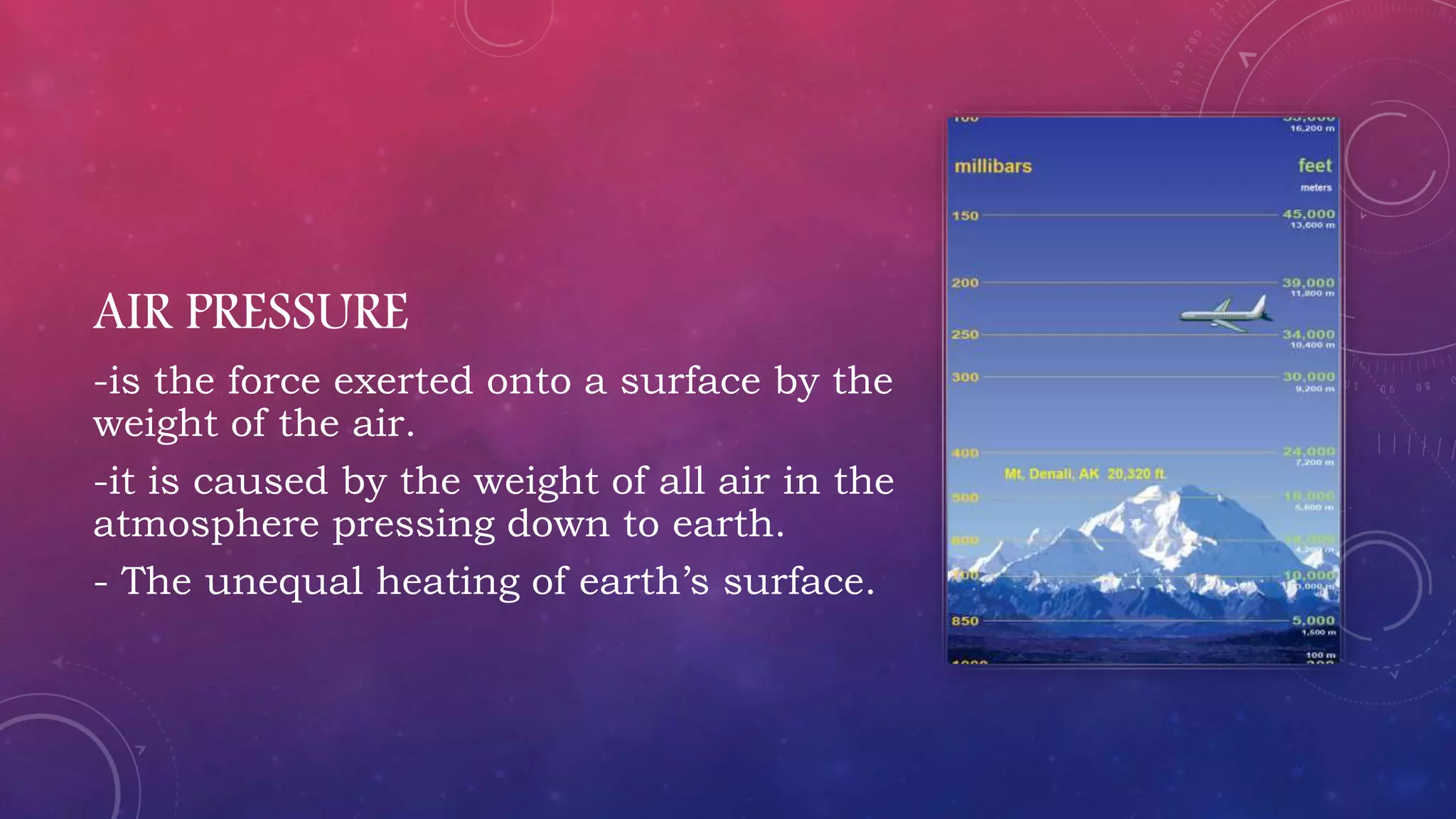
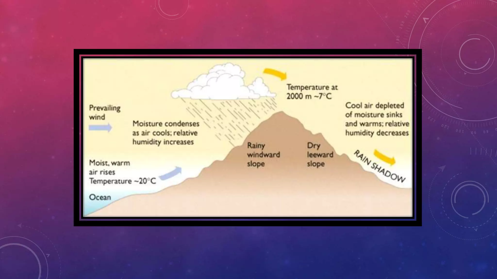
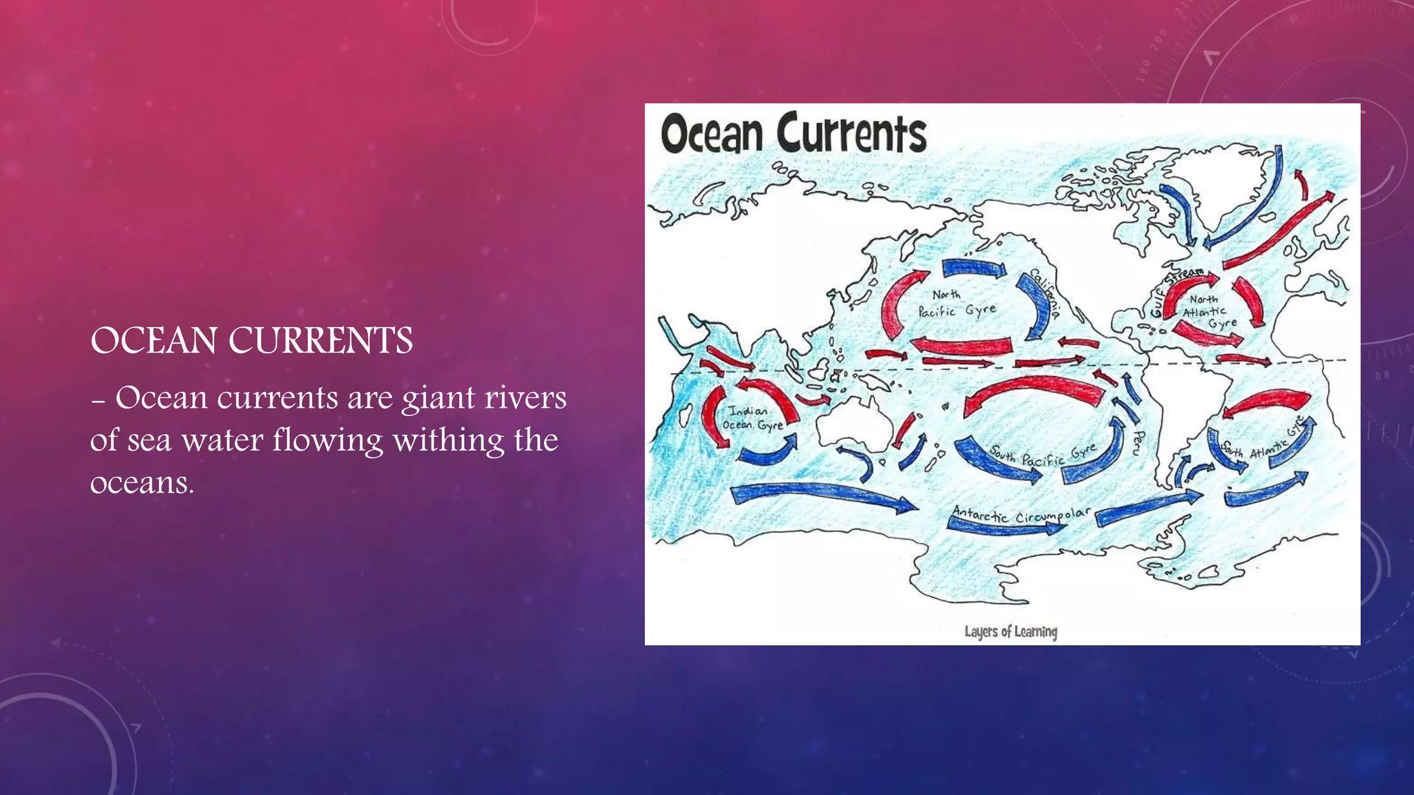
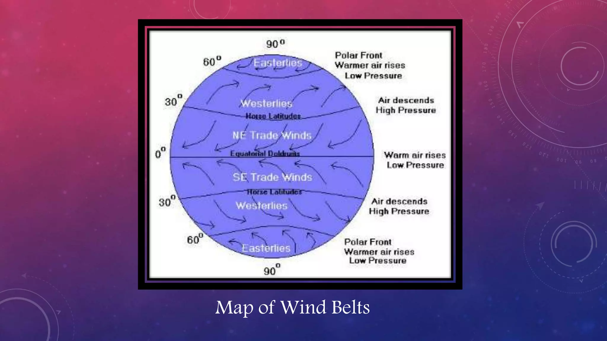
Weather refers to short-term atmospheric conditions in a location, such as temperature, wind, and precipitation. Climate describes general weather conditions in a place over a longer period of time, usually years. Climate is influenced by factors like the water cycle, Earth's tilt and rotation, volcanic eruptions, and greenhouse gases, while weather is affected in the short term by wind speed, cloud cover, and types of precipitation.
Weather refers to atmospheric conditions in a specific time and place, while climate describes typical weather in a region over many years. There are five elements of weather: wind, atmospheric conditions, temperature, precipitation, and humidity. Climate is influenced by climatic factors like latitude, altitude, and distance from bodies of water. There are three main climate zones - polar, tropical, and temperate. Climate change due to global warming is raising Earth's temperatures and causing sea levels to rise through melting ice, with potential consequences like drought and species extinction. Proposed solutions include reducing deforestation, pollution, and energy waste.
The document discusses global wind patterns that develop due to temperature differences between the equator and poles. Warm air rises at the equator, creating low pressure, while cold air sinks at the poles, creating high pressure. Air moves from high to low pressure areas, resulting in global wind currents called the prevailing westerlies, easterly trade winds, and polar easterlies in both hemispheres. The Coriolis effect causes these winds to curve right in the northern hemisphere and left in the southern hemisphere as they travel.
Weather refers to atmospheric conditions over a short period of time, while climate describes average weather patterns over many years. In the Philippines, PAG-ASA monitors and forecasts weather by observing elements like temperature, precipitation, winds, and clouds. Latitude, altitude, topography, and proximity to bodies of water all impact climate by influencing how much solar radiation and moisture an area receives. Different wind systems like the trade winds and polar winds also affect Philippine weather and seasonal climate patterns.
The document discusses six main climate factors:
1) Latitude - The distance north or south of the equator determines temperature, with polar regions being cooler and tropical regions being warmer.
2) Altitude - Higher elevations experience cooler temperatures as air loses heat as it rises.
3) Land-Water Relationship - Large bodies of water moderate temperatures while land experiences more temperature variation.
4) Mountain Barriers - Mountains block moisture-carrying winds, creating wet and dry sides.
5) Ocean Currents - Ocean currents influence wind temperatures and rainfall along coasts.
6) Prevailing Winds - Global wind patterns are driven by differences in land and sea temperatures.
The document discusses air masses and fronts. It defines air masses as large bodies of air with uniform properties that form over land or water surfaces. There are four main types of air masses classified by their region of formation: maritime/continental and polar/tropical. Fronts are boundaries between unlike air masses. There are three main types of fronts: cold fronts, where cold air overtakes warm air; warm fronts, where warm air overtakes cold air; and occluded fronts, where a warm air mass is overtaken by two cooler air masses.
There are many factors that influence a region's climate, including latitude, altitude, proximity to water bodies, air pressure systems, solar radiation, ocean currents, and the amount of urban development. Latitude determines a location's position north or south, affecting sunlight exposure and temperature. Altitude and topography also impact temperature, with colder conditions at higher elevations. Bodies of water and differences between land and sea areas further modify local climates.
The document discusses key concepts relating to climate and climate change. It defines climate as the overall weather pattern of a region over a long period of time, typically 30 years. It is influenced by several factors, including latitude, altitude, distance from large bodies of water, ocean currents, and topography. Climate change refers to long-term shifts in global weather patterns and is exacerbated by human activities that release greenhouse gases and increase carbon dioxide levels in the atmosphere. Climate change can have drastic effects including rising sea levels, more severe weather events, and threatened extinction of plant and animal species.
During the day, the sea breeze blows from the sea to land as the air over the land warms up faster than the air over the water. At night, the land breeze blows from land to sea as the land cools down faster than the water due to the water's higher specific heat capacity, causing the air over the water to become warmer and less dense than the air over the land. The document defines and describes the sea breeze and land breeze patterns that occur daily as a result of the differing ways land and water absorb and release heat.
The document defines key terms related to weather and climate such as weather, climate, season, temperature, humidity, air pressure, and winds. It describes how weather is the short term atmospheric conditions of a place while climate refers to average conditions over a longer period. Seasons result from the Earth's revolution and axis tilt. Temperature, precipitation, air pressure, winds, and visibility are the main elements that determine weather and climate in a given place. Factors like heat, air pressure, winds, and moisture interact to cause weather. Major wind systems like the doldrums, trade winds, horse latitudes, and prevailing westerlies result from differences in heating and the Coriolis effect.
The document discusses various factors that influence weather and climate:
- Weather refers to short-term atmospheric conditions over a small area, while climate describes average conditions over a larger area for an extended period.
- Key climate determinants in India include latitude, altitude, pressure systems, distance from the sea, ocean currents, and relief features. The monsoon climate brings seasonal reversal of winds and heavy rainfall to much of the country.
This document discusses global wind patterns. It begins by explaining that wind is the movement of air from high to low pressure areas. It then describes how wind is formed through convection currents caused by uneven heating of the Earth's surface from the sun. The Coriolis effect causes winds to curve due to the Earth's rotation. There are local winds formed by local geographic features and global winds formed by larger air masses. Global wind types include polar easterlies, prevailing westerlies, trade winds, and doldrums. Prevailing winds typically blow from west to east in the mid-latitudes. Nepal experiences a temperate climate due to its location in the Himalayas between the Tropic of Cancer and Arctic
TEMPERATURE
COMPOSITION OF THE ATMOSPHERE
Layers of the ATMOSPHERE
WEATHER and CLIMATE
LATITUDINAL ZONES
ELEMENTS & CONTROLS OF WEATHER & CLIMATE
WARM MAJOR CURRENTS OF THE WORLD
Land Breeze & Sea Breeze
The document discusses sea breezes and land breezes, which are caused by differences in how quickly land and water absorb and release heat. Water has a higher specific heat than land, so it warms and cools more slowly. During the day, land is heated faster by the sun through radiation. Warmer air over land rises through convection, pulling in the cooler air from over the ocean, creating a sea breeze. At night, land cools faster while the ocean retains heat, reversing the convection currents and forming a land breeze as the cooler air over land moves over the ocean.
This document summarizes key concepts about Earth's atmosphere and weather. It describes the four main layers of the atmosphere, how temperature and pressure vary with altitude. It also explains atmospheric phenomena like humidity, dew point, condensation, cloud types, global wind patterns, air masses, fronts, and severe weather events like thunderstorms, tornadoes and hurricanes.
Wind is caused by differences in air pressure and is responsible for weather patterns globally. The main drivers of wind include solar heating of the atmosphere creating pressure differences, the Coriolis effect which causes winds to bend, and pressure gradient force pushing air from high to low pressure areas. Global wind systems include the trade winds near the equator, the prevailing westerlies in mid-latitudes, and polar easterlies near the poles. Local winds are also influenced by differences in land and sea temperatures.
This document provides information about weather, climate, and climates of the Philippines for a 120 minute lesson in high school earth science. It defines weather and climate, describes factors that influence climate such as latitude, altitude, proximity to bodies of water, and prevailing winds. It also outlines the four climate types in the Philippines and discusses the northeast and southwest monsoon wind systems that influence the country's seasonal rainfall patterns.
Major ocean currents include surface currents driven by wind and deep currents caused by density differences related to water temperature and salinity. Surface currents circulate near the ocean surface and influence climate regions, with warm currents making areas warmer and wetter. Deep currents circulate thermal energy and nutrients globally. The Coriolis effect causes surface currents to curve right in the Northern Hemisphere and left in the Southern Hemisphere. Upwelling occurs when wind moves surface water and deeper cold water rises to the surface, bringing nutrients. The Great Ocean Conveyor Belt model describes the large-scale ocean circulation system that transfers thermal energy around the world through sinking and upwelling of waters.
This document provides an overview of weather and climate concepts. It discusses how weather is caused by differences in temperature and air pressure between locations. It also describes common weather phenomena and how weather is forecasted using various instruments and models. The document outlines different climate zones and variables that influence climate. It explains phenomena like El Niño and hurricanes and how climate change is impacting environments and societies.
1. Air pressure is caused by the weight of the atmosphere and is exerted in all directions. It is measured using a barometer.
2. Wind is caused by differences in air pressure and is affected by pressure gradients, the Coriolis effect, and friction. Unequal heating of the Earth's surface creates pressure differences.
3. The atmosphere circulates in cells with air rising at the equator and sinking at the poles, driven by pressure and temperature differences. This circulation creates global wind patterns like the trade winds and westerlies.
Fronts are boundaries between two air masses of differing characteristics. There are four main types of fronts: cold fronts, warm fronts, occluded fronts, and stationary fronts. Cold fronts are steep boundaries where cold air overrides warm air, bringing precipitation. Warm fronts are more gradual, with light, continuous precipitation as warm air rises over cold air. Occluded fronts occur when a cold front catches up to a warm front. Stationary fronts have little or no movement as the air masses are parallel.
Maritime tropical air masses form over warm waters and bring warm, moist air into parts of the United States. Continental polar air masses form over snow-covered northern Canada and bring cold, dry air into central and eastern portions of the country. When warm and cold air masses meet, fronts are formed. Cold fronts have steep slopes that can produce heavy precipitation like thunderstorms and hail, while warm fronts have more gentle slopes and cause lighter, longer-lasting precipitation from nimbostratus clouds. Occluded fronts occur when a cold front catches up to a warm front.
This document discusses climate and weather, as well as the global factors that influence climate. It defines climate as the composite weather conditions for a location over a long period, usually 20-30 years. Weather is the short term atmospheric conditions at a place and time. The main global climatic factors discussed are the quality and quantity of solar radiation, the tilt of the Earth's axis, and how radiation is distributed at the Earth's surface based on cosine law, atmospheric depletion, and sunlight duration. Regional climate is influenced by these global factors as well as local geography.
This document discusses air masses and fronts. It defines air masses as large bodies of air that extend thousands of kilometers and have uniform temperature and humidity. Air masses form over source regions and are classified as either tropical or polar, and continental or maritime. Fronts occur at the boundary between differing air masses and can be cold, warm, stationary or occluded fronts. Each front type brings characteristic weather conditions from rain to thunderstorms as the warmer air is displaced.
The document discusses the four main systems that make up Earth: the atmosphere, hydrosphere, biosphere, and geosphere. It focuses on describing the layers of the atmosphere, including the exosphere, thermosphere, mesosphere, stratosphere, and troposphere. The troposphere contains most of the weather and clouds and temperatures decrease with increased altitude. The stratosphere contains ozone that absorbs UV radiation. The mesosphere is the coldest part while the thermosphere reaches temperatures over 1,700°C and protects the Earth from radiation.
Fronts occur where two different air masses meet but do not mix. There are four main types of fronts: cold fronts, warm fronts, stationary fronts, and occluded fronts. Cold fronts move quickly and bring cooler, drier air behind them, often causing rain and storms. Warm fronts move more slowly and bring cloudy skies and light rain before warmer, more humid air moves in. Stationary fronts occur when neither air mass can push the other, resulting in prolonged wet weather. Occluded fronts form when a warm air mass gets trapped between two cold fronts.
This document discusses the properties of gases and air. It explains that gases have mass and take up space, have faster moving molecules than solids and liquids, expand to fill their container, have molecules spaced far apart with no bonds or fixed shape, and can be compressed. It then discusses the composition of air, temperature, pressure, density, humidity, and other gas properties.
The document discusses six key factors that affect climate: latitude, altitude, distance from the sea, relief, pressure and wind systems, and ocean currents. Latitude affects temperature, with tropical regions being hot, polar regions being cold, and temperate regions having moderate temperatures. Altitude also influences temperature, with temperatures decreasing as elevation increases. Proximity to the sea moderates climate, while inland areas experience more extreme temperatures. Relief such as mountains can act as barriers or influence rainfall distribution. Pressure and wind systems determine rainfall amounts and patterns. Ocean currents also impact local climate, with warm currents raising and cold currents lowering temperatures.
Ocean currents are influenced by factors like the sun, wind, Coriolis effect, and gravity. Warm currents generally flow away from the equator while cold currents flow toward it. The sun heats water in the tropics, making it less dense and causing it to rise and flow poleward. Wind pushes surface water and the Coriolis effect causes it to curve, forming giant circular gyres in ocean basins. Examples are the Gulf Stream, which brings warmer water to northwest Europe. Upwelling occurs when offshore winds pull surface waters, causing deeper cold water to rise.
The document discusses several key factors that influence climate:
1) Latitude determines tropical, temperate, and polar climate zones.
2) Pressure systems and winds influence where tropical rainforests and deserts are located.
3) Ocean currents impact regional climates.
4) Distance from the coast (continentality) affects temperature, as land warms and cools faster than oceans.
Oceans impact climate through ocean currents formed by convection as warm water rises and cold water sinks, creating weather patterns like hurricanes and wind. Ocean waters vary in salinity or amount of salt due to different factors. Convection in ocean currents processes warm and cold water to impact global weather patterns.
This document discusses the climate and topography of Africa. It notes that over 50% of Africa has inadequate precipitation and 92% experiences climatic contrasts with shortage of water in some areas and oversupply in others. About 8% has a tropical climate with rainfall 10-12 months per year. Africa has about one-third of the world's arid lands and temperature variations are not excessive, though lower plains and desert regions experience great heat. The most important climatic differences are due to rainfall variations.
The document defines and explains topography and topographic maps. It describes how topographic maps use contour lines to represent elevation, with closer lines indicating steeper slopes. Contour lines circle around mountains and point upstream along streams. Other symbols convey features like roads, vegetation, buildings and landforms. Index contours are labeled to indicate the contour interval elevation difference between lines. Topographic maps provide visual information about natural and man-made terrain.
This document provides an overview of the early history and development of the theory of plate tectonics. It discusses how early maps from Eratosthenes and Crates began to document topography and elevation patterns on Earth. In the late 1800s, scientists like Alexander von Humboldt, Antonio Snider-Pellegrini, and Edward Seuss began recognizing patterns in the shapes and fossil records of continents that suggested they were once joined together. In the early 1900s, scientists like Frank Taylor and Alfred Wegener proposed the first hypotheses of continental drift to explain these patterns, though Wegener's ideas faced skepticism at the time due to the unknown forces driving plate motions.
This chapter discusses weather and climate. It defines weather as short-term atmospheric conditions, while climate refers to longer-term patterns over 30-35 years. Weather is described by temperature, humidity, precipitation, pressure and winds. Temperature is influenced by factors like latitude, altitude, distance from the sea, and cloud cover. Humidity refers to water vapor in the air. Precipitation forms as rain or snow depending on temperature. Air pressure decreases with altitude as air molecules are farther apart. Winds blow from high to low pressure areas. Sea and land breezes are influenced by differences in how land and sea absorb heat.
The document discusses several key factors that affect climate:
1. Latitude - Places closer to the equator receive more direct sunlight and have a warmer climate, while areas farther from the equator have a colder climate due to the sun's rays striking at a lower angle.
2. Altitude - Higher elevations have lower air pressure and temperature, with air temperature decreasing approximately 6.5°C for every 1000 meters gained in elevation.
3. Distance from large bodies of water - Oceans and seas moderate nearby climate by slowly absorbing and releasing heat, preventing large fluctuations in air temperature.
The document discusses atmospheric circulation and weather systems. It explains that uneven heating of the Earth's surface causes pressure differences in the atmosphere which drive wind patterns. Key factors that determine winds include temperature, pressure, humidity, and the forces of pressure gradient, friction, and the Coriolis effect from the Earth's rotation. It describes global wind systems like the Hadley, Ferrel, and polar cells that comprise the general circulation. It also covers local winds, air masses, fronts, and storm systems like cyclones, thunderstorms, and tornadoes.
Weather and Climate power point.
Weather and Climate power point.Weather and Climate power point.Weather and Climate power point.
Weather and Climate power point.Weather and Climate power point.
Weather and Climate power point.
Weather and Climate power point.Weather and Climate power point.
Weather and Climate power point.
Climate is defined as the long-term weather patterns of a particular region, averaged over a period of 30 years. It is influenced by several factors including solar radiation, latitude, elevation, wind, ocean currents, and the amount of precipitation an area receives. Together these factors help determine the temperature and moisture levels of different parts of the world, which then influence the types of climates and ecosystems that exist in each region. As climate change causes rising global temperatures, many species are experiencing shifts in their natural ranges and changes to the timing of seasonal life cycles in order to adapt to the altering environmental conditions.
This document discusses global air circulation patterns driven by uneven heating of the atmosphere. It describes three main factors that influence winds: pressure gradient force, Coriolis force, and friction force. Unequal heating creates high and low pressure systems that drive winds according to these forces. The document outlines the major wind systems in different latitudes, including the trade winds near the equator; westerlies in mid-latitudes between subtropical highs and subpolar lows; and polar easterlies near the poles. Diagrams are provided showing typical January and July surface pressure patterns and winds in each region.
The document defines wind as the movement of air from high to low pressure areas. Wind direction is measured with a weather vane and speed with an anemometer. Local winds like sea breezes and land breezes are caused by differences in land and ocean temperatures at night and during the day. Global winds like trade winds and prevailing westerlies are caused by uneven heating of the Earth's surface and the Coriolis effect, forming convection currents that influence weather patterns worldwide.
Winds are caused by differences in air pressure due to the uneven heating of the atmosphere. Warm air rises and cool air moves in to replace it, creating high and low pressure areas and winds that blow from high to low pressure. The Coriolis effect causes winds in the Northern Hemisphere to curve right and winds in the Southern Hemisphere to curve left. Global wind patterns include the doldrums at the equator, trade winds between 30 degrees latitude, prevailing westerlies from 30 to 60 degrees, and polar easterlies near the poles.
The document discusses how oceans and mountains affect weather and climate. It states that oceans moderate temperatures worldwide by absorbing heat more slowly than land. Cities near oceans, like San Francisco, tend to have milder temperatures than inland cities at the same latitude, like Nashville. Mountains also influence climate by causing rising air to cool and produce rain on their windward sides, while their leeward sides receive less rain and are warmer.
The document discusses what causes wind and differences in air pressure. It explains that wind is caused by differences in air pressure as air moves from high to low pressure areas. Differences in air pressure are created by factors like differential heating from the sun, which causes temperature extremes; precipitation processes that generate low pressure as air rises; convection currents in the atmosphere; and the Coriolis effect from the Earth's rotation. Specific wind patterns like sea breezes, land breezes, monsoons, jet streams, and Chinook winds are also summarized.
The document discusses the composition and importance of Earth's atmosphere. It can be summarized as follows:
1) Earth's atmosphere is made up primarily of nitrogen and oxygen gases which support life by providing breathable air and nourishing plant growth.
2) The atmosphere also regulates Earth's climate and weather patterns through factors like temperature, precipitation, air pressure, and wind.
3) It protects the planet from harmful rays and materials from space while trapping heat via the greenhouse effect, maintaining a livable temperature range.
The document discusses air temperature and factors that influence it. It defines air temperature as a measure of the kinetic energy of air molecules, with higher temperatures indicating faster molecule movement. Key points:
- Air temperature is dependent on the amount of heat gained or lost at the earth's surface from solar radiation, varying between day and night as well as by location.
- Several factors influence air temperature, including latitude, altitude, distance from bodies of water, cloud cover, humidity, wind, and land surface type.
- Temperature is typically measured in degrees Celsius, Fahrenheit or Kelvin. Inversions can occur where warmer air sits above cooler surface air, acting as a lid and limiting convection.
This document discusses the various factors that affect climate, including:
1) Latitude - The farther away from the equator, the colder the climate becomes.
2) Air pressure - Low pressure brings warm, moist air and clouds while high pressure brings cold, dry air and clear skies.
3) Mountain barriers - Mountains can create rainshadows on their leeward sides, affecting climate.
That's a high-level three sentence summary of the key points covered in the document.
weather cells and systems, jet streams, climate changekarapatidivya
The document discusses the global atmospheric circulation system consisting of three cells - Hadley, Ferrel, and Polar cells - driven by uneven solar heating. It describes features of each cell like direction of winds and formation of high/low pressure zones. Jet streams occurring at cell boundaries are discussed along with weather systems like air masses, frontal systems, mid-latitude cyclones, and extreme events. The implications of climate change like rising temperatures, changing precipitation patterns, sea ice loss, sea level rise, and ocean acidification are summarized.
weather cells and systems jet streams climate change and implicationsDivyaKarapati
The document discusses the global atmospheric circulation system consisting of three cells - Hadley, Ferrel, and Polar cells - driven by uneven solar heating. It describes features of each cell like direction of winds and formation of high/low pressure zones. Jet streams occurring at cell boundaries are discussed along with weather systems like air masses, frontal systems, mid-latitude cyclones, and extreme events. The implications of climate change like rising temperatures, changing precipitation patterns, sea ice loss, sea level rise, and ocean acidification are summarized.
- The document discusses factors that influence temperature patterns and atmospheric circulation, including latitude, land/water distribution, altitude, cloudiness, and ocean currents.
- It describes the global circulation pattern of convection in the tropics creating the ITCZ, descent of air at 30° creating subtropical highs, and deflection of winds by the Coriolis effect into the trade winds and westerlies.
- Polar highs also form due to descent, with polar easterlies and frontal zones forming where polar and subtropical air masses meet. Local winds like sea breezes and land breezes also influence temperature patterns.
Air pressure decreases with increasing altitude and is affected by temperature, humidity, and elevation. It is measured using a barometer. Differences in air pressure cause winds to move from high to low pressure areas. Global wind patterns like trade winds and jet streams curve due to the Coriolis effect. Local winds are influenced by geographic features and temperature variations between land and bodies of water. Changes in weather occur when different air masses characterized by their temperature and moisture content meet at fronts like cold fronts and warm fronts, which can lead to thunderstorm formation.
The document discusses several key factors that influence climate, including latitude, elevation, winds, ocean currents, and large-scale weather phenomena like El Niño. Latitude plays a major role, with cooler climates found at higher latitudes and warmer climates near the equator. Elevation also influences climate, with temperatures generally decreasing about 3.5 degrees F for every 1,000 feet gained in elevation. Winds and ocean currents distribute heat around the planet and influence weather patterns and temperatures in coastal regions.
Weather and storms are influenced by air masses and fronts. Air masses are large bodies of air that are classified by their source region (polar or tropical) and surface (continental or maritime). Fronts are boundaries between differing air masses. Thunderstorms develop through strong updrafts and produce lightning and thunder. Other storms include hurricanes, which form over warm ocean waters, and tornadoes, which are rotating columns of air. The ozone layer protects the Earth by absorbing UV radiation but is depleted by CFC emissions. El Niño is a phenomenon associated with extreme climate shifts.
1. The document discusses various weather phenomena including air pressure, wind, air masses, fronts, and storms. It provides definitions and explanations of these concepts.
2. Key terms that are defined include high and low pressure systems, isobars, warm and cold fronts, thunderstorms, tornadoes, and hurricanes. Measurement tools like barometers and anemometers are also explained.
3. Visuals like diagrams and videos are referenced throughout to enhance understanding of complex weather patterns and interactions between different elements.
The ability to recreate computational results with minimal effort and actionable metrics provides a solid foundation for scientific research and software development. When people can replicate an analysis at the touch of a button using open-source software, open data, and methods to assess and compare proposals, it significantly eases verification of results, engagement with a diverse range of contributors, and progress. However, we have yet to fully achieve this; there are still many sociotechnical frictions.
Inspired by David Donoho's vision, this talk aims to revisit the three crucial pillars of frictionless reproducibility (data sharing, code sharing, and competitive challenges) with the perspective of deep software variability.
Our observation is that multiple layers — hardware, operating systems, third-party libraries, software versions, input data, compile-time options, and parameters — are subject to variability that exacerbates frictions but is also essential for achieving robust, generalizable results and fostering innovation. I will first review the literature, providing evidence of how the complex variability interactions across these layers affect qualitative and quantitative software properties, thereby complicating the reproduction and replication of scientific studies in various fields.
I will then present some software engineering and AI techniques that can support the strategic exploration of variability spaces. These include the use of abstractions and models (e.g., feature models), sampling strategies (e.g., uniform, random), cost-effective measurements (e.g., incremental build of software configurations), and dimensionality reduction methods (e.g., transfer learning, feature selection, software debloating).
I will finally argue that deep variability is both the problem and solution of frictionless reproducibility, calling the software science community to develop new methods and tools to manage variability and foster reproducibility in software systems.
Exposé invité Journées Nationales du GDR GPL 2024
The use of Nauplii and metanauplii artemia in aquaculture (brine shrimp).pptxMAGOTI ERNEST
Although Artemia has been known to man for centuries, its use as a food for the culture of larval organisms apparently began only in the 1930s, when several investigators found that it made an excellent food for newly hatched fish larvae (Litvinenko et al., 2023). As aquaculture developed in the 1960s and ‘70s, the use of Artemia also became more widespread, due both to its convenience and to its nutritional value for larval organisms (Arenas-Pardo et al., 2024). The fact that Artemia dormant cysts can be stored for long periods in cans, and then used as an off-the-shelf food requiring only 24 h of incubation makes them the most convenient, least labor-intensive, live food available for aquaculture (Sorgeloos & Roubach, 2021). The nutritional value of Artemia, especially for marine organisms, is not constant, but varies both geographically and temporally. During the last decade, however, both the causes of Artemia nutritional variability and methods to improve poorquality Artemia have been identified (Loufi et al., 2024).
Brine shrimp (Artemia spp.) are used in marine aquaculture worldwide. Annually, more than 2,000 metric tons of dry cysts are used for cultivation of fish, crustacean, and shellfish larva. Brine shrimp are important to aquaculture because newly hatched brine shrimp nauplii (larvae) provide a food source for many fish fry (Mozanzadeh et al., 2021). Culture and harvesting of brine shrimp eggs represents another aspect of the aquaculture industry. Nauplii and metanauplii of Artemia, commonly known as brine shrimp, play a crucial role in aquaculture due to their nutritional value and suitability as live feed for many aquatic species, particularly in larval stages (Sorgeloos & Roubach, 2021).
The debris of the ‘last major merger’ is dynamically youngSérgio Sacani
The Milky Way’s (MW) inner stellar halo contains an [Fe/H]-rich component with highly eccentric orbits, often referred to as the
‘last major merger.’ Hypotheses for the origin of this component include Gaia-Sausage/Enceladus (GSE), where the progenitor
collided with the MW proto-disc 8–11 Gyr ago, and the Virgo Radial Merger (VRM), where the progenitor collided with the
MW disc within the last 3 Gyr. These two scenarios make different predictions about observable structure in local phase space,
because the morphology of debris depends on how long it has had to phase mix. The recently identified phase-space folds in Gaia
DR3 have positive caustic velocities, making them fundamentally different than the phase-mixed chevrons found in simulations
at late times. Roughly 20 per cent of the stars in the prograde local stellar halo are associated with the observed caustics. Based
on a simple phase-mixing model, the observed number of caustics are consistent with a merger that occurred 1–2 Gyr ago.
We also compare the observed phase-space distribution to FIRE-2 Latte simulations of GSE-like mergers, using a quantitative
measurement of phase mixing (2D causticality). The observed local phase-space distribution best matches the simulated data
1–2 Gyr after collision, and certainly not later than 3 Gyr. This is further evidence that the progenitor of the ‘last major merger’
did not collide with the MW proto-disc at early times, as is thought for the GSE, but instead collided with the MW disc within
the last few Gyr, consistent with the body of work surrounding the VRM.
hematic appreciation test is a psychological assessment tool used to measure an individual's appreciation and understanding of specific themes or topics. This test helps to evaluate an individual's ability to connect different ideas and concepts within a given theme, as well as their overall comprehension and interpretation skills. The results of the test can provide valuable insights into an individual's cognitive abilities, creativity, and critical thinking skills
Travis Hills' Endeavors in Minnesota: Fostering Environmental and Economic Pr...Travis Hills MN
Travis Hills of Minnesota developed a method to convert waste into high-value dry fertilizer, significantly enriching soil quality. By providing farmers with a valuable resource derived from waste, Travis Hills helps enhance farm profitability while promoting environmental stewardship. Travis Hills' sustainable practices lead to cost savings and increased revenue for farmers by improving resource efficiency and reducing waste.
Comparing Evolved Extractive Text Summary Scores of Bidirectional Encoder Rep...University of Maribor
Slides from:
11th International Conference on Electrical, Electronics and Computer Engineering (IcETRAN), Niš, 3-6 June 2024
Track: Artificial Intelligence
https://www.etran.rs/2024/en/home-english/
ESPP presentation to EU Waste Water Network, 4th June 2024 “EU policies driving nutrient removal and recycling
and the revised UWWTD (Urban Waste Water Treatment Directive)”
Current Ms word generated power point presentation covers major details about the micronuclei test. It's significance and assays to conduct it. It is used to detect the micronuclei formation inside the cells of nearly every multicellular organism. It's formation takes place during chromosomal sepration at metaphase.
This presentation explores a brief idea about the structural and functional attributes of nucleotides, the structure and function of genetic materials along with the impact of UV rays and pH upon them.
Unlocking the mysteries of reproduction: Exploring fecundity and gonadosomati...AbdullaAlAsif1
The pygmy halfbeak Dermogenys colletei, is known for its viviparous nature, this presents an intriguing case of relatively low fecundity, raising questions about potential compensatory reproductive strategies employed by this species. Our study delves into the examination of fecundity and the Gonadosomatic Index (GSI) in the Pygmy Halfbeak, D. colletei (Meisner, 2001), an intriguing viviparous fish indigenous to Sarawak, Borneo. We hypothesize that the Pygmy halfbeak, D. colletei, may exhibit unique reproductive adaptations to offset its low fecundity, thus enhancing its survival and fitness. To address this, we conducted a comprehensive study utilizing 28 mature female specimens of D. colletei, carefully measuring fecundity and GSI to shed light on the reproductive adaptations of this species. Our findings reveal that D. colletei indeed exhibits low fecundity, with a mean of 16.76 ± 2.01, and a mean GSI of 12.83 ± 1.27, providing crucial insights into the reproductive mechanisms at play in this species. These results underscore the existence of unique reproductive strategies in D. colletei, enabling its adaptation and persistence in Borneo's diverse aquatic ecosystems, and call for further ecological research to elucidate these mechanisms. This study lends to a better understanding of viviparous fish in Borneo and contributes to the broader field of aquatic ecology, enhancing our knowledge of species adaptations to unique ecological challenges.
13. AIR PRESSURE
-is the force exerted onto a surface by the
weight of the air.
-it is caused by the weight of all air in the
atmosphere pressing down to earth.
- The unequal heating of earth’s surface.
14. HOW DOES THE AIR PRESSURE AFFECTS THE
CLIMATE?
• Air pressure in the weather system reflects the amount of water in
the air, which affects the weather.
•LOW air pressure usually results in BAD weather: Stormy,
cloudy overcast.
•HIGH air pressure tends to result in GOOD weather: CLEAR
skies, no precipitation.
15. HOW DOES THE AIR PRESSURE AFFECTS THE
CLIMATE?
• Low pressure is warm, moist air. It raises and forms
clouds.
• High pressure is cold, dry air. It sinks and creates clear
skies.
19. OROGRAPHIC EFFECT
• Wind containing the moisture hits the windward side of a
mountain. The moisture full of clouds to make it over the
mountain so precipitation occurs.
• After the rain the clouds have no moisture and are able to rise
over the mountain. The side away from the mountain is the
leeward side. The leeward side of the mountain arid, it’s in the
rainshadowand is usually a desert.
23. EFFECTS OF ELEVATION TO CLIMATE
• As elevation increases, temperature decreases.
• As well as, as the elevation decreases, the temperature increase.
25. CONTINENTAL
LOCATION
- The position of a location on a
continent relative to the ocean
determine whether it is a marine or
continental climate.
26. CONTINENTAL LOCATION
• Large bodies of water are slower to heat and cool than land.
• As a result, water temperatures remains stable and land
temperature changes frequently.
• Coastlines have stable temperatures.
• Interior of the continent has extreme temperatures (hotter and
colder).
28. OCEAN CURRENTS
- Ocean currents are giant rivers
of sea water flowing withing the
oceans.
29. OCEAN CURRENTS
• Ocean currents flow in circular path:
1. Warm currents carry water from low to high altitudes. These
make land nearby warmer.
2. Cool currents carry water from high to low altitudes. These make
land nearby cooler.
31. WIND BELTS
- Wind is the movement of the
air from high pressure to low
pressure.
32. TYPES OF WIND BELTS
• Trade Winds
a wind blowing steadily toward the equator from the northeast in
the northern hemisphere or the southeast in the southern
hemisphere, especially at sea. Two belts of trade winds encircle the
earth, blowing from the tropical high-pressure belts to the low-
pressure zone at the equator.
33. TYPES OF WIND BELTS
• Westerlies
a wind blowing from the west.
the belt of prevailing westerly winds in the mid-latitudes
of the northern and southern hemispheres.
34. TYPES OF WIND BELTS
• Polar Easterlies/Winds
are the dry, cold prevailing winds that blow from the high-
pressure areas of the polar highs at the North and South Poles
towards low-pressure areas within the Westerlies at high
latitudes.